- 176 pages
- English
- ePUB (mobile friendly)
- Available on iOS & Android
eBook - ePub
About this book
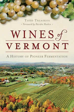
Vermont's extreme climate may not seem ideal for wine production, but industry pioneers are proving otherwise. For nearly half a century, local winemakers developed distinctive fermentation techniques and adopted select crops to withstand icy winters. In 1970, Frank Jedlicka used traditional recipes to make wine with apples, maple and honey. North River and Grand View followed with other orchard and berry fruits. Harrison Lebowitz planted French hybrid grapes on a Lake Champlain island in the 1990s, and soon Vermont hosted some of America's first true cold-climate vineyards. Fresh tastes and resurrected flavors now symbolize the Green Mountain State's ripening wine industry. Todd Trzaskos reveals Vermont's identity as an innovative and maturing wine producer.
Information
Topic
HistoireSubtopic
Histoire de l'Amérique du NordPart I
THE TERROIR OF VERMONT
You can’t get there from here.
—New England proverb
Students of wine spend much of their time swirling glasses and then sipping and spitting to evaluate quality. For the most serious, study goes deeper, into the weather and the rock and soil from which the wine derives. Burgundy is often touted for its fossilized limestone basement and the Willamette Valley of Oregon for its formation by postglacial flood. Vermont’s landform has a history similar to both yet more ancient and complex than either. Renowned for its colorful autumn spectacle, Vermont’s other seasons are also distinctive in their beauty and severity, and it is within this cycle of the year that wine grows. This uniquely formed land and the intensity of its climate draw a certain kind of person to make a life in this place and, even more special, those who make that life into wine.
The word terroir, when directly translated into English from French, is understood as “land.” However, as employed in the wine world, terroir is imbued with deeper meanings often distilled to the brief description “a sense of place.” This may be a somewhat vague notion to the uninitiated, leaving much room for interpretation. Terroir is used broadly in France, where it is applied to all agricultural products that have the capacity to reflect the place and circumstance in which they are grown. While the concept is not uniquely French, the Gallic gustatory culture is often held up as the gold standard for honoring the good life that can be experienced at a communal dinner table laden with local produce and a serviceable wine in the glass. In the United States, terroir is almost exclusively reserved for the domain of wine and, given our mercantile society, there are those who fear the principle has been coopted by sales and marketing departments to such an extent that it threatens to dilute the concept, stripping terroir of the nuance it is intended to convey.
Over the course of a few hundred years in ancient Burgundy, monks dutifully tended and documented their vineyards and then used their detailed observations of the productivity of vines and the quality of the wines to make delineations among parcels. Centuries later, modern science is able to identify specific influences under the earth and in the macroclimate above that convey distinct and distinguishable features on wines made from grapes of the same variety but grown in different locations, even if very nearby. The Burgundian story may provide inspiration for those interested in the roots of Vermont wine, encouraging an examination of the ground and the climate that define the Green Mountain State’s physical identity.
During his career as a respected professor of economic geology at Brock University in Ontario, Simon Haynes became one of the first to publish a work on terroir in North America with a series of papers called “Geology of Wine,” which appeared beginning in 1999. Haynes defined terroir as that which results from the combined influences of geography, geology, soils, meteorology, hydrology and growing practices. These are the vectors through which the fruits of the land derive their existence and their unique essence.
Geology concerns itself with deep rocks, the prehistoric foundation on which the structure of geography is built. Geography, in turn, describes the shape of the terrain and the qualities of the surface soils that cloak it. Those soils can be quite uniform in some places and, in others, present an amalgam of deposits from distant sources combined with local material produced by the slow process of erosion. Weather has predominating patterns that determine a region’s baseline climate, but even weather is influenced by geography that can spawn seasons and local events ranging from the idyllic to the extreme. Weather delivers water to the place. Hydrology determines the path by which that water will move from higher locations to lower, through the soils and following the path of least resistance into ponds and brooks, lakes and rivers and, finally, to the sea.
To each of these studies, Vermont presents its own complexities. Interactions between the state’s unique geology, varied landscape and variable weather create a seemingly infinite number of macroclimates that vary widely from the region’s “normal” ranges of temperature and precipitation. Differences among sites are striking and impressive, as are the personalities of the people who choose these places in which to make wine. The Hillis family’s Butler Island vineyard on Lake Champlain is accessible only by boat, sitting 125 feet above sea level and surrounded by water but receiving relatively little precipitation in the Champlain Valley, whereas Joe Klimek’s high-altitude vineyard on a ridge 1,100 feet above the Mad River Valley may accumulate almost twice as much precipitation in any year. The rich and geologically recent glacial clay deposit beneath Lincoln Peak Vineyard in Addison County nourishes an extremely vigorous growth pattern in the vines that requires constant taming and thinning. Meanwhile, the vines at Newhall Farm are more challenged and need to be nurtured from thinner surface soils that cling to a 440-million-year-old dolomite structure.
The borders of Vermont are of two kinds. The eastern and western boundaries take their shape from clear geographic features in the form of major watersheds. The northern and southern lines, on the other hand, are entirely abstract political lines that slice through the landscape with little regard to its natural shape and having little effect on separating the cultures that straddle them. This is an important point because the story of how Vermont’s population and culture developed is a layered one, influenced by immigration and by a porous social history influenced from both the north and south. Over time, each layer of this story has provided cultural building material, developing toward the social climate required for wine to take root.
Including human activity in a study of terroir is controversial for some. However, if we consider terroir as an intellectual construct, then we can also appreciate that the human community producing the wine is, itself, a product of the place. It may be especially true in Vermont—where human habitation and transit have always followed the waterways and valleys—that physical geography informs social culture and the growth of culture has the power to transform the landscape. The raw plant materials of wine are agents of the earth’s expression, and human hands are shepherds of a magical process that would not otherwise occur. This interaction between nature and its offspring tells a story and conveys a sense of place to those who are willing to listen for and to taste what is in their glass.
The most important lesson to absorb when considering the factors that produce the wines of Vermont is that they cannot be described as one homogenous collection. We can be sure that, if they reflect anything at all, it is variety.
VERMONT ROCK
Edward Hitchcock, former president of Amherst College and eminent state geologist for Massachusetts and then Vermont, took on the survey of the Green Mountains. In his 1859 Report on the Geology of Vermont, a project that had taken numerous contributors and decades to complete, he professes both his amazement and admiration for what he found. He wrote, “The rocks of Vermont are the most difficult with which I have ever had to grapple, but they have taught me many a valuable lesson…most important of all, we think we have discovered the reason why Vermont so excels all the other New England States in the agricultural capabilities of its soil.” Referencing the latter statement, Hitchcock identified the widespread presence of limestone as a key ingredient to farm fertility. The former exclamation arose from the challenge he faced in making sense of enigmatic geologic formations that, in most cases, would take another century to be explained.
Hitchcock’s surveys include important information about periods of geologic change that took place in Vermont and provide clues to the very origins of landmasses on the earth. Orogeny is the geological term for “mountain building,” oros for “mountain” linked with genesis for “creation” giving rise to the common word origin. Members of the Appalachian chain, the Green Mountains are some of the oldest rock on the surface of the planet, nearing a half billion years. They are rivaled only by the older Adirondacks, remnants of the world’s first mountains, with which they have been neighbors since separate births an eternity ago. It often comes as a surprise when people learn that the Lake Champlain Valley, so far from the seashore, is home to a 500-million-year-old tropical coral fossil bed, the oldest in existence, twice older than the limestone fossils under Burgundy. These corals, along with remains of the first creatures to swim in that shallow warm ocean, have been found in the Champlain basin in startling proximity to the fossils of cold ocean whales that swam there a mere one hundred centuries ago. Ledges and outcroppings around Vermont provide windows into the underlying strata and in some places expose the curiosity of very old metamorphic rock thrown over top of much younger formations. These oddities dotting the landscape were confounding to researchers until the theories of continental glaciation in the nineteenth century, and plate tectonics in the 1960s, helped to unravel the mysteries.
In researching the geology of Vermont, one quickly realizes that a doctoral degree in earth sciences would be of great assistance. One is also assisted by a strong imagination with which to conjure a scale of time so far beyond human comprehension. The prehistoric eras can be overwhelming to parse, and the scope of the changes astounding, so the attempt here will be to provide a broad overview of the tale and point out important aspects. The curious student of wine and earth is encouraged to dig deeper.
The landmass of Vermont began at the edge of the North American continental core, Laurentia, at the center of Earth’s first supercontinent, Rodinia. Rodinia was formed a billion years ago as the first landmasses came together and threw up mountains from fifteen miles or more underground. Today, the Adirondack Mountains are the only remains visible at the surface. Rodinia remained intact for 300 million years until, as it broke apart, Laurentia began migrating northward from its position in the southern hemisphere. The land that is now Vermont was a flat, reef-like structure submerged off Laurentia’s southern shore. As the plates separated, proto-Vermont was towed along for 100 million years through the shallow Iapetus Ocean, which grew increasingly warmer as Laurentia traveled north toward the equator. The Champlain basin, which today traces a north–south line, was at the time oriented from east to west, and the impressive Ordovician fossil reserves in the valley, remains of the earliest sea life, were deposited at this time.

Ordovician fossils in the Champlain Valley.
Eventually, the earth’s plates changed direction and moved toward one another in a tectonic process that drove one landmass under another, compressing and thrusting up the sea floor and piling it up against the Laurentian shore and the Adirondack Dome. This process formed the Taconic Mountains of southeastern Vermont 425 million years ago, also raising volcanic islands out to sea that became the roots of the White Mountains in New Hampshire. The movement caused a shrinking of the Iapetus Ocean separating Laurentia from the neighboring landmass of Gondwana, setting the two continents and the island chain between them on a collision course. When the landmasses came together, the proto-European continental plate dove under the North American one, the force drove subsurface material upward and the next major mountain building event took place. As the arc of volcanic islands slowly crashed into the Laurentian shore, powerful action like a great plow pushed material, folding and transforming rock for hundreds of miles. The plates rose up and compressed the ancient seabed, forming the Green Mountains 390 million years ago, with the White Mountains to follow, until both continental masses fully converged and formed the ancient continent of Pangea. Proto-Vermont was now situated firmly inland, and dinosaurs were beginning to roam this new version of the earth.
Things stayed fairly quiet for the next 20 million years as Pangea oriented itself near the equator until the plates began to separate once more. The resulting fragments of land moved toward locations we can now more easily recognize on a map. In the process, numerous remnants were left behind—clues geologists have used to explain what transpired. In brief, Vermont was left with a bedrock laminate with lines running in the north–south orientation and composed of ten different primary rock materials of varying ages, from 1 billion to 100 million years. The bedrock geology of Vermont is sometimes described as a deck of cards, with the deepest layers in the west and the uppermost layers in the east. These sheets of bedrock create a multitude of fractures as they project above the earth’s crust. The overlaps in the rock show themselves as block and thrust faults throughout the landscape.
VERMONT ICE
The theory of glaciation gained acceptance earlier than did the theory of plate tectonics, which makes sense if we consider that the ice sheets left far more discernible markers behind. A series of frozen ages over the course of 100 million years, with each age obscuring the action of the previous, leaves us with only the tracks of the last great retreat some 13,500 years ago. At its peak, the Laurentide ice sheet was over one mile thick, burying the land more deeply than one thousand modern-day snowstorms could ever accomplish. The slow-motion gyrations of ice had the most significant shaping effects on the terrain that Vermonters now traverse since the time when the mountains were first created.
Through several advances and retreats, glaciers scoured the base rock and milled down materials that were deposited across the terrain as the ice pack diminished. Glaciers carved watersheds and left behind great lakes on either side of the Green Mountain ridge. Lake Hitchcock (named after Edward Hitchcock by later colleagues in respect for his work interpreting the traces glaciation left behind) formed the Connecticut Valley to the east, flowing south. In the west, Lake Vermont filled what is now the Champlain Valley and ran north. There were also numerous high mountain lakes in just about every river valley. The lakes were formed by runoff trapped behind the ice and glacial debris, leaving Vermont with gravel beaches high up on mountainsides and sedimentary silts and clays at the bottom of its valleys.
Rock debris deposited as glaciers retreated north range in size from the finest silt to boulders the size of small houses. Eventually, glacial lakes let loose their cobbled dams and catastrophic volumes of water rushed out, carrying earth material downstream. Twelve thousand years ago, in one major event, Lake Vermont drained three hundred feet in a matter of hours or days, and the Champlain Valley dried out for a short time. As sea levels rose with global ice melt, ocean waters flowed inland. Lake Vermont became the Champlain Sea and, for the first time in 400 million years, would host saltwater creatures again.

Augers help in planting vines in glacial deposits. Mad River Vineyard.
The weight of the ice sheets was so enormous that it had compressed the land. Without the weight of ice, in time the earth began to rise up again, lifting the Champlain basin until it was again allowed to drain north toward the ocean. The present-day lake has an average depth of sixty-f...
Table of contents
- Front Cover
- Half Title
- Title Page
- Copyright
- Contents
- Foreword, by Deirdre Heekin
- Acknowledgements
- Introduction
- Part I: The Terroir of Vermont
- Part II: Wine Culture
- Part III. Fruits of the Land
- Part IV. Farmers and Winemakers
- Part V. Harvesting Support and the Future
- Selected Bibliography
- About the Author
Trusted by 375,005 students
Access to over 1.5 million titles for a fair monthly price.
Study more efficiently using our study tools.
Frequently asked questions
Yes, you can cancel anytime from the Subscription tab in your account settings on the Perlego website. Your subscription will stay active until the end of your current billing period. Learn how to cancel your subscription
No, books cannot be downloaded as external files, such as PDFs, for use outside of Perlego. However, you can download books within the Perlego app for offline reading on mobile or tablet. Learn how to download books offline
Perlego offers two plans: Essential and Complete
- Essential is ideal for learners and professionals who enjoy exploring a wide range of subjects. Access the Essential Library with 800,000+ trusted titles and best-sellers across business, personal growth, and the humanities. Includes unlimited reading time and Standard Read Aloud voice.
- Complete: Perfect for advanced learners and researchers needing full, unrestricted access. Unlock 1.5M+ books across hundreds of subjects, including academic and specialized titles. The Complete Plan also includes advanced features like Premium Read Aloud and Research Assistant.
We are an online textbook subscription service, where you can get access to an entire online library for less than the price of a single book per month. With over 1.5 million books across 990+ topics, we’ve got you covered! Learn about our mission
Look out for the read-aloud symbol on your next book to see if you can listen to it. The read-aloud tool reads text aloud for you, highlighting the text as it is being read. You can pause it, speed it up and slow it down. Learn more about Read Aloud
Yes! You can use the Perlego app on both iOS and Android devices to read anytime, anywhere — even offline. Perfect for commutes or when you’re on the go.
Please note we cannot support devices running on iOS 13 and Android 7 or earlier. Learn more about using the app
Please note we cannot support devices running on iOS 13 and Android 7 or earlier. Learn more about using the app
Yes, you can access Wines of Vermont by Todd Trzaskos in PDF and/or ePUB format, as well as other popular books in Histoire & Histoire de l'Amérique du Nord. We have over 1.5 million books available in our catalogue for you to explore.