- 240 pages
- English
- ePUB (mobile friendly)
- Available on iOS & Android
eBook - ePub
History Lover's Guide to Chicago, A
About this book
Founded next to a great lake and a sluggish river, Chicago grew faster than any city ever has. Splendid department stores created modern retailing, and the skyscraper was invented to handle the needs of booming businesses in an increasingly concentrated downtown. The stockyards fed the world, and railroads turned the city into the nation's transportation hub. A great fire leveled the city, but Chicago rose again. Glorious museums, churches and theaters sprang up. Explore a missile site that became a bird sanctuary and discover how Chicago's first public library came to be located in an abandoned water tank. Follow the steps of business leaders and society dames, anarchists and army generals, and learn whose ashes were surreptitiously sprinkled over Wrigley Field. Combining years of research and countless miles of guided tours, author Greg Borzo pursues Chicago's sweeping historical arc through its fascinating nooks and crannies.
Trusted by 375,005 students
Access to over 1.5 million titles for a fair monthly price.
Study more efficiently using our study tools.
Information
Subtopic
North American HistoryIndex
HistoryCHAPTER 1
EARLY CHICAGO
Ancestors of the Native Americans came from Asia, crossing the Bering Strait to North America about twenty thousand years ago. They worked their way south, eventually becoming the first in a long line of immigrants to what’s now called Chicago. The Indians viewed the marshy area as inhospitable—cold in the winter, hot in the summer, short growing season and lacking trees and game. In addition, they had little use for the sluggish, shallow river. A stinky, garlicy, wild onion that was called chicagoua by the Indians and shikaakwa by the French grew in the area, but the swampy land was not fertile for the Indians’ preferred crop: maize.
Throughout the 1700s and into the 1800s, intertribal conflict occurred frequently. At one point, the Illinois prevailed, but they were later dominated by the Iroquois. The Miami and eventually the Pottawatomi came to control the region.
Europeans, who began arriving in the region during the mid-1600s, were initially attracted by plentiful fur and motivated by a desire to convert Indians to Christianity. The French explorers quickly recognized the importance of the Chicago River and Mud Lake, a small marsh a few miles inland, as potential links between the Great Lakes and the Mississippi River.
NICHOLAS J. MELAS CENTENNIAL FOUNTAIN
North Bank of the Chicago River at McClurg Court
Chicago is flat despite such misnomers as Archer Heights, Mount Greenwood and more. Nevertheless, Chicago straddles a modest continental divide—not a mountain range, but an elevation of 630 feet above sea level, compared with about 580 feet above sea level for Lake Michigan. The divide runs north–south along the western edge of the city.
Inaugurated in 1989, the Centennial Fountain lays out how water flows westward and eastward from this divide. The center represents Chicago, and six steps on the west side of the fountain represent the Chicago River, Sanitary and Ship Canal, Des Plaines River, Illinois River, Mississippi River and Gulf of Mexico. Six steps on the east side represent Lakes Michigan, Huron, Erie and Ontario; the Saint Lawrence Seaway; and the Atlantic Ocean.
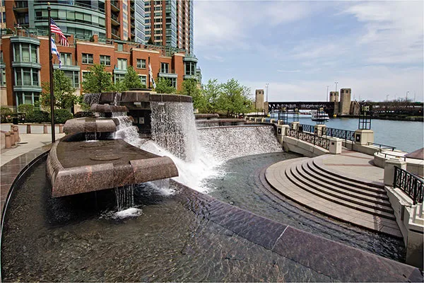
The Centennial Fountain displays how water to the west of Chicago’s continental divide flows to the Mississippi River; to the east, it flows to the Atlantic Ocean. Photo by Julia Thiel.
CHICAGO PORTAGE NATIONAL HISTORIC SITE
4800 South Harlem Avenue
Native Americans welcomed the French, guided them through the region and showed them a shortcut between the Mississippi River and the Great Lakes via the Illinois River, the Des Plaines River, Mud Lake and the Chicago River. When Mud Lake was wet, voyageurs could canoe through; when it was low or dry, they had to portage. This historic site marks where explorers would have traversed Mud Lake through what was known as the Chicago Portage. The site includes a wilderness area and a memorial statue commemorating the voyageurs.
French explorers Louis Jolliet and Jacques Marquette are credited with the idea of building a canal connecting the Chicago and Des Plaines Rivers in 1673 as they canoed through the region on an expedition designed to map the area for France.
Jolliet wrote, “The great and important advantage” presented by a prospective canal “will hardly be believed. We could go with facility to Florida in a bark and by very easy navigation. It would only be necessary to make a canal by cutting through half a league” (about one mile) of the marsh. The modest, hand-dug Illinois and Michigan Canal was completed in 1848 and operated until 1933. It was replaced in 1900 with a parallel and much wider waterway, the twenty-eight-mile Chicago Sanitary and Ship Canal.
As a Jesuit missionary, Marquette was primarily interested in converting Native Americans. He established good relations with the Indians, learning their customs and languages. In 1674–75, Marquette overwintered in what would become Chicago and, months later, died while preaching to Indians in the area. If Chicago had a patron saint, it would be Marquette. Several monuments honor him, and schools, streets, a building and a park are named after him.
MARQUETTE MONUMENT
Damen Avenue, North of the Chicago River
This forlorn, ten-foot-tall bronze monument depicts Marquette interacting with an Indian. It was erected in 1930 near one spot where Marquette is thought to have overwintered in 1674–75. Don’t be alarmed by the swastikas on the monument; before the Nazis appropriated it, the swastika was an ancient symbol of divinity and good luck.
MARQUETTE BUILDING
140 South Dearborn Street
Four large bronze panels outside the entrance to this handsome, classical building constructed in 1895 depict the missionary’s work throughout the Midwest. They portray a revered, peaceful Marquette among Native Americans. The building’s must-see, two-story lobby is magnificent and welcoming to the public. It features mosaic scenes of Marquette’s travels.
MARQUETTE AND JOLLIET PLAQUE
DuSable Bridge, East Sidewalk
A small plaque installed in 1925 celebrates Marquette and Jolliet as “the first white men to pass through the Chicago River. September 1673.”
MARQUETTE AND JOLLIET STATUE
24th Street and Marshall Boulevard
Installed in 1926, this twelve-foot-tall bronze grouping focuses on Marquette holding a cross. Jolliet and an Algonquin guide stand beside him.
Jolliet never inspired modern-day Chicagoans the way Marquette did, perhaps because strong Catholic influences throughout Chicago’s early history favored a missionary priest working for the glory of God more than an explorer working for the glory of France. In addition, Marquette’s journals survived his travels, while Jolliet’s travel papers and maps were lost when his canoe capsized in 1763. Still, Jolliet was eventually honored in 1845 when Juliet, Illinois, was renamed Joliet in his honor—although the town misspelled his name!
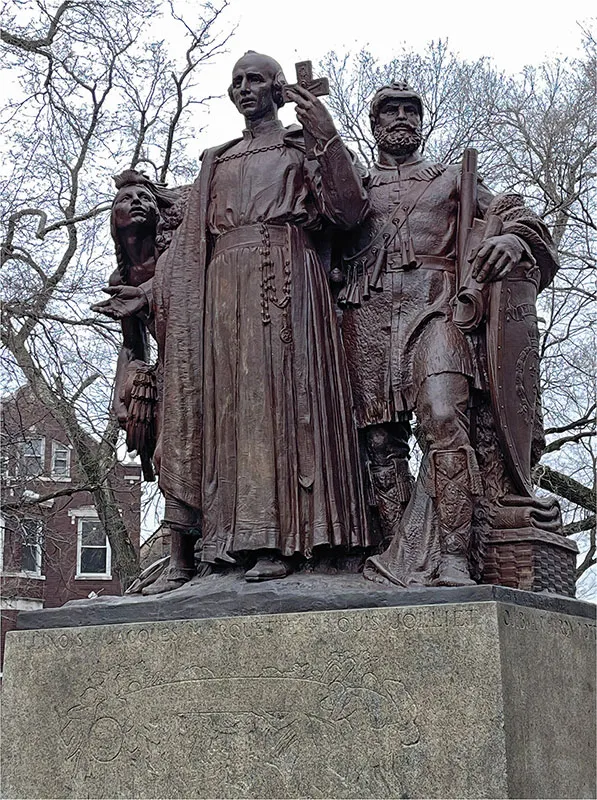
This statue at 24th Street and Marshall Boulevard honors Marquette and Jolliet, both of whom traveled through the area for France in the 1670s.
In 1666, Robert Cavelier de La Salle began exploring New France. He built several forts in the Mississippi River Valley on behalf of King Louis XIV. In 1682, La Salle passed through Chicago, where he built a cabin and stockade along the river. During that trip, upon reaching the source of the Mississippi River, he boldly declared, “I take possession in the name of His Majesty and successors of his crown of this country, Louisiana.”
La Salle shared Marquette and Jolliet’s enthusiasm for a canal and predicted that Chicago would become “a gate of commerce.” He helped the French establish a stronghold in the Midwest well before the British. If it hadn’t been for Napoleon’s impetuous sale of the Louisiana Territory to the United States in 1803, Chicagoans might be speaking French today.
ROBERT CAVELIER DE LA SALLE STATUE
LaSalle Drive and Clark Street
This bronze statue of a rugged-looking La Salle bears witness to France’s early inroads in America, as do other things in Chicago, such as schools, a bank, a luxury hotel and an important street that are named after the intrepid explorer. La Salle was tough, as shown in this statue, where he’s not dressed in French finery but rather armed with pistol and sword.
During the first half of the 1700s, the region around Chicago remained a backwater, frequented primarily by Indigenous people but increasingly by the French, British and, eventually, a great number of Americans. When the French and Indian War ended in 1763, Britain gained control of the region, but its hold was tenuous, in part because Chicago was relatively unimportant on the worldwide stage. With the American Revolution, however, the “Old Northwest” became hotly contested.
George Rogers Clark, surveyor, soldier and brother of Merriweather Clark (of Lewis and Clark fame), won control of the region for the Americans in 1778 by capturing Forts Kaskaskia and Vincennes from the British. Given that Clark was a Virginia militia officer, he claimed the territory for Virginia (which didn’t become a state until 1788). Therefore, the Illinois County remained under the jurisdiction of Virginia’s House of Burgesses until 1784, when the land was ceded to the federal government.
Clark Street is named after this Virginian soldier. This demonstrates that investigating seemingly mundane street names reveals many fascinating facts and surprising stories. Drake Avenue is named after John Drake, who bought a large downtown hotel during the Chicago Fire and reaped a fortune after the fire spared his new purchase by a few feet. Nina Avenue is named after one of the three ships Christopher Columbus sailed to America, although his other ships have not been similarly recognized. And Solidarity Drive was renamed in 1980 to show solidarity with Polish labor leader Lech Walesa.
The most appropriate street name must be Brennan Avenue, named after Edward Brennan, the mastermind of Chicago’s orderly street numbering system that was implemented beginning in 1909. All of this is interestingly recounted in Streetwise Chicago: A History of Chicago Street Names, by Don Hayner and Tom McNamee. Incidentally, Brennan is one of the few people to have both a street and an honorary street named after him. The honorary street system was inaugurated in 1984 and is well described in Honorary Chicago: The Who, Where and Why of Chicago’s Brown Honorary Street Signs, by Linda Zabors.
For decades before and after 1800, the area around Chicago continued to be diverse and multicultural. Jean Baptiste Point DuSable, a Haitian of French and Caribbean descent, and Kitiwaha, aka Catherine, Point DuSable, his Potawatomi wife, fit in well when they arrived circa 1779. They stayed rather than pass through, as traders were wont to do, making them Chicago’s first permanent nonindigenous residents. The DuSables built a substantial homestead and trading post near present-day Pioneer Court.
DUSABLE MONUMENT
401 North Michigan Avenue
This bust of Jean Baptiste Point DuSable was installed in 2009 near the location of his homestead, which included a house, mill, bakery, dairy, poultry house, smokehouse, two barns and dozens of animals.
DuSable must have been educated and well-to-do. He also had the advantage of being married to a Potawatomi. Their work helped transform Chicago from a frontier trading post into a settlement. Nevertheless, Americans were reluctant to settle in Chicago during the time the DuSables lived here due to fear of hostility from Native Americans, who were trying to hold back the rising flood of newcomers. In the Battle of Fallen Timbers in 1794, Americans defeated a force of Indians and British. In the resulting Treaty of Greenville, Indians ceded to the United States a six-square-mile parcel of land at the mouth of the Chicago River, as well as use of the Illinois River and the portage through Mud Lake.
The DuSables sold their settlement in 1800 and moved away. In 1804, their former property ended up in the hands of John Kinzie, who promoted himself as the city’s father. For early Chicagoans and the writers of their history, a white Protestant Scotsman involved in trade and politics was a “more fitting city father” than a Black man married to an Indian woman, as Dominic Pacyga wrote in his excellent book Chicago: A Biography. Only recently has DuSable been recognized for his role in helping to establish Chicago.
Fort Dearborn was built in 1803 to establish U.S. claims to the region. The Treaty of St. Louis (1816) ceded additional lands to the white settlers, in particular a corridor of land twenty miles wide that ran roughly parallel to the Chicago and Illinois Rivers for approximately seventy miles southwest from the lake. The northern edges of this corridor became known as the Indian Boundary Line, which ran along what is now Rogers Avenue. A plaque at Rogers and Clark Streets commemorates this treaty, and Indian Boundary Park (near Western Avenue and Lunt Street) derives its name from the line.
During the War of 1812, Fort Dearborn was abandoned and burned to the ground by Native Americans. As a result, the settlement of Chicago was virtually abandoned. But the British lost the war and abandoned the region. This left many Native Americans who had sided with the British to fend for themselves. The area remained depopulated until the fort was rebuilt in 1816, which reintroduced a flow of traders and, more importantly, settlers. As a result, the Indians were relentlessly pushed out and forced to cede more tribal lands.
WOLF POINT PLAZA
Confluence of the Main Stem of the Chicago River with Its Branches
In the 1820s, taverns and inns popped up at Wolf Point, which became the center of the raucous, polyglot settlement. Today it’s a commercial and residential hotspot, dominated by gleaming high-rises. Tens of thousands of tour boats, water taxis, electric pontoons and recreational kayaks pass by all summer.
As more settlers arrived and more treaties were broken, the Indians were pushed completely out of the Chicago area. The Black Hawk War (1832– 33) put an end to Native American prospects in the region and forced most Indians to move west of the Mississippi River.
Decades later, many Native Americans moved to cities across the country, including Chicago. In the 1950s and 1960s, the federal government’s controversial Indian Relocation program moved thousands of Indians to Chicago. Today, Chicagoland is home to more than sixty-five thousand, representing more than 140 tribal nations. They’re concentrated in Uptown, Edgewater and Rogers Park. Many have assimilated, while others maintain strong ties to their traditional communities.
AMERICAN INDIAN CENTER
3401 West Ainslie Street
Founded in 1953, the AIC is the country’s oldest urban-based Native American community center. Through relief services, education and support programs, it promotes the physical and spiritual health of the community and fosters connections with traditional values and practices. It also holds powwows open to the public.
THE ALARM
East of Lake Shore Drive at Wellington Avenue
Dating back to 1884, this is the oldest monument erected in a Chicago park and the first one in the entire city that depicted Native Americans. It shows Indians as peaceful, family orien...
Table of contents
- Front Cover
- Title Page
- Copyright
- Contents
- Introduction: The Glorious Lakefrontt
- 1. Early Chicago
- 2. Military Matters
- 3. Libraries
- 4. Clubs, Colonies and Communities
- 5. Cemeteries
- 6. Disasters
- 7. Buildings and Residences
- 8. Transportation around Town
- 9. Churches
- 10. Museums
- 11. Universities
- 12. Sports
- 13. Monuments, Markers and Memorials
- About the Authort
Frequently asked questions
Yes, you can cancel anytime from the Subscription tab in your account settings on the Perlego website. Your subscription will stay active until the end of your current billing period. Learn how to cancel your subscription
No, books cannot be downloaded as external files, such as PDFs, for use outside of Perlego. However, you can download books within the Perlego app for offline reading on mobile or tablet. Learn how to download books offline
Perlego offers two plans: Essential and Complete
- Essential is ideal for learners and professionals who enjoy exploring a wide range of subjects. Access the Essential Library with 800,000+ trusted titles and best-sellers across business, personal growth, and the humanities. Includes unlimited reading time and Standard Read Aloud voice.
- Complete: Perfect for advanced learners and researchers needing full, unrestricted access. Unlock 1.5M+ books across hundreds of subjects, including academic and specialized titles. The Complete Plan also includes advanced features like Premium Read Aloud and Research Assistant.
We are an online textbook subscription service, where you can get access to an entire online library for less than the price of a single book per month. With over 1.5 million books across 990+ topics, we’ve got you covered! Learn about our mission
Look out for the read-aloud symbol on your next book to see if you can listen to it. The read-aloud tool reads text aloud for you, highlighting the text as it is being read. You can pause it, speed it up and slow it down. Learn more about Read Aloud
Yes! You can use the Perlego app on both iOS and Android devices to read anytime, anywhere — even offline. Perfect for commutes or when you’re on the go.
Please note we cannot support devices running on iOS 13 and Android 7 or earlier. Learn more about using the app
Please note we cannot support devices running on iOS 13 and Android 7 or earlier. Learn more about using the app
Yes, you can access History Lover's Guide to Chicago, A by Greg Borzo in PDF and/or ePUB format, as well as other popular books in History & North American History. We have over 1.5 million books available in our catalogue for you to explore.