As disputes concerning the environment, the economy, and pandemics occupy public debate, we need to learn to navigate matters of public concern when facts are in doubt and expertise is contested.
Controversy Mapping is the first book to introduce readers to the observation and representation of contested issues on digital media. Drawing on actor-network theory and digital methods, Venturini and Munk outline the conceptual underpinnings and the many tools and techniques of controversy mapping. They review its history in science and technology studies, discuss its methodological potential, and unfold its political implications. Through a range of cases and examples, they demonstrate how to chart actors and issues using digital fieldwork and computational techniques. A preface by Richard Rogers and an interview with Bruno Latour are also included.
A crucial field guide and hands-on companion for the digital age, Controversy Mapping is an indispensable resource for students and scholars of media and communication, as well as activists, journalists, citizens, and decision makers.
Trusted by 375,005 students
Access to over 1.5 million titles for a fair monthly price.
In this chapter, we learn about controversies as a way to study science in society, design better technological solutions or promote democratic inquiry, but also why controversies can be hard to navigate and why mapmaking is never neutral.
Controversies tend to get cartographers caught up in their mess. This can be both awkward and laborious, and it raises the question of why one should engage with controversy mapping in the first place. If you already align with a specific viewpoint, mapping a controversy can seem like a waste of time. If you know who is right and who is wrong, why bother considering the other positions? If all you want is to tip a scale, there are more efficient ways to do it than through mapmaking. But even if you genuinely want to help actors find their way around the debate, you will find that mapping is always in the interest of some and to the detriment of others.
By treating controversies as “generative events” (Whatmore, 2009), i.e. not as problems that need fixing but as occasions to investigate public debate when the social fabric is under transformation, controversy mapping highlights their troubles rather than explaining them away. This attention is not always welcomed and the very act of calling something a controversy can itself be controversial. Indeed, making the complexity of a controversy manifest can run directly contrary to the agenda of those who rely on simplification to make their point. No matter how hard you try to be impartial, in a controversy you are either complicit or irrelevant. To become a mapmaker is to accept complicity. The question, then, is not how to keep your hands clean, but why get them dirty?
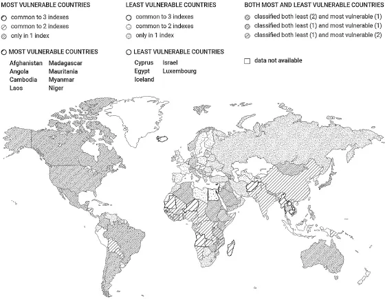
In 2013, we were working on a research project exploring the use of Electronic Maps to Assist Public Science (EMAPS) around climate change (Venturini et al., 2014b). One of the issues we worked with was vulnerability indexes, i.e. ways of measuring countries’ exposure to climate change impacts and thus decide the distribution of adaptation aid. One of the maps we produced (figure 6) illustrates how three of the most common climate vulnerability indexes diverge in their assessment. Countries like Australia, Canada, Germany, or Brazil, for example, are considered very vulnerable by some indexes and not vulnerable by others.
Figure 6 Map of how three different indexes of vulnerability disagree in assessing countries’ vulnerability to climate change. Only countries with a bold border are classified unanimously as either most or least vulnerable by all three indexes (adapted from the EMAPS project, climaps.eu and licensed under CC BY-SA 4.0).
The map in figure 6 visualizes a central aspect of the controversy, namely that climate change vulnerability can mean different things and hence be assessed in different ways. It does not, however, take sides in the matter, at least not in the sense of accusing one index as being in the pocket of a given country, or writing off another index as unscientific. Yet, the map may still run against the interest of some actors. This is a field where plenty of countries and non-governmental organizations (NGOs) have well-informed opinions about how vulnerability should be evaluated or how to guide funding. Countries that provide adaptation aid, for instance, may not welcome the occasion to question how they spend their money. Funding bodies may fear that studying the situation as a controversy will give visibility to arguments that they would rather silence or show a diversity of opinions that would make their own position less obvious.
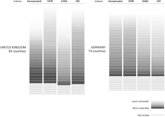
Realizing that there is no disinterested representation of the vulnerability debate, we decided to design a new map exploring how the interests of different adaptation funders align with different indexes. In figure 7, we matched the way countries distribute their adaptation aid with the vulnerability of receiving countries according to different indexes. Canada, for example, helps countries that are vulnerable according to the GAIN index, but not according to the Germanwatch index. The UK, on the other hand, spends money on countries that are not particularly vulnerable according to any of the indexes.
Figure 7 Bilateral adaptation funding and vulnerability indexing. The chart shows how the recipients of adaptation aid from different countries are considered vulnerable (dark) or not vulnerable (light) by different vulnerability indexes. Adaptation aid provided by the UK, for instance, aligns well with the vulnerability assessments of the Global Adaptation Index (GAIN) or the Human Development Index (HDI), much less so with DARA’s. Germany’s aid instead aligns more with the assessment of the Germanwatch and GAIN indexes (adapted from the EMAPS project, climaps.eu and licensed under CC BY-SA 4.0).
While some adaptation actors may prefer not to see the partiality of funders and indexes exposed in this way, there are many others, NGOs in particular, who do. It is not always easy to pry open a space for debate once national policies have been set and the visualizations in figure 7 can help with that.
By following the actors and showing their stakes in particular issues, as in points 1 and 2 of the cartographic creed, controversy mapping cannot avoid serving some interest over others. Such complicity comes with responsibilities, at the very least to be reflexive and transparent about your motives, as in point 3 of the creed. You might attempt to open a space for democratic inquiry, as in the example above, or to show how different commitments produce different outlooks or how different knowledge claims have authority in different groups. You could also aim to help decision makers, journalists, or other actors to make sense of the debate or take a stance in it. The point of your mapping could be to highlight different perspectives to help those who will eventually design a solution to do so in fullest view of the concerns they have to balance. Last but not least, the point of mapping a controversy could be to exploit an opportunity to do interesting research. It is not every day that you have the possibility to observe how economic, social, and ecological indicators are balanced against each other to produce the combined assessment of a country’s vulnerability and how this is a source of struggle behind the front desk communication of international aid.
Accepting complicity as a mapmaker
In his history of cartography, John Wilford (2002) recounts how, in the early days of aerial surveying, cartographers were occasionally attacked by people on the ground who mistook the mappers for a threat and met them with spears and arrows. Critical geographer Patrick McHaffie, however, suggests a different reading:
Perhaps the “frightened Africans” who once “threw spears at an Aero Service aircraft” or the “suspicious moonshiners in Appalachia” who “took a few rifle shots” at aerial mappers did so not because the intentions of the mappers were “not always understood,” but because those intentions, and the powerful forces behind them, were understood only too well. (McHaffie, 1995, p. 122)
Maps are not just tools for navigation but also instruments of power and appropriation, subversion and resistance, leverage and negotiation. This has been demonstrated time and time again in critical geographical scholarship (Harley & Woodward, 1987; Harley, 1989; Turnbull, 1994, 1998; Pickles, 1995, 2004; Corner, 1999). As Eilean Hooper-Greenhill notes: “to be ‘on the map’ is to be acknowledged, given a position, accorded an existence or an importance” (2000, p. 17). Whether such recognition is desirable or not depends on the situation. The scientist chasing funding or the NGO striving to set the public agenda will likely want to be charted as influencers. Yet, while being left off the map can consign you to oblivion, it can also grant you protection. A group of indigenous people resisting appropriation by a state will likely prefer not to see their territory on a plan of taxable land; just like homeowners trying to obtain flood insurance do not want to see their property on a map of high-risk areas (Munk, 2010). Maps matter and this is true for geography as well as for controversies (November et al., 2010).
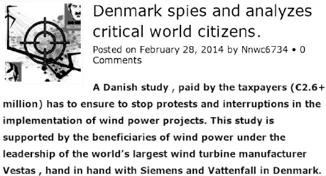
Figure 8 Controversy mappers accused of spying on wind turbine opponents. Meme circulated worldwide by anti-wind websites, including the European Platform Against Windfarms, caricaturing a controversy mapping project carried out by one of the authors (Munk, 2014) as Nazi and authoritarian.
While working on a project on energy transitions, one of us was tasked with mapping online debates about wind farms (Munk, 2014). The sample included wind energy advocates and opponents from several countries and the project was to trace their hyperlink connections and the issues present on their websites. Some of the early maps found their way to protest groups who reacted vehemently and decried them as an example of how the wind industry was spying on them. The maps were adorned with Nazi imagery (see figure 8) and compared to the methods used by the US National Security Agency (NSA) in counter-terrorism work.
This reaction demonstrates how actors can mistrust maps, but also strategically re-frame them (in this case, as evidence of organized persecution). Maps travel and lend themselves to being used in ways that were not always intended by their makers. They are, as James Corner remarks, “not prescriptive, but infinitely promising” (1999). Being unable to fully anticipate the consequences of our mapmaking reminds us of the impossibility of keeping our hands clean. The project to map wind energy controversies was funded by the Danish Council for Strategic Research in a consortium that comprised industry partners as well as municipal developers. It was therefore reasonable to expect that any piece of research coming out of that project could be framed as partisan. And yet it is important not to confuse this situation with a resignation to doing the bidding of the wind industry. The overall objective of the project was to develop a more robust procedure for planning. In that context, doing controversy mapping meant insisting that those procedures should not misrepresent the concerns of wind energy opponents. Prior to the project, the narrative of both the wind industry and municipal developers had been that opposition was mainly coming from a small band of issue professionals, hopping from one turbine project to the next, stirring up public sentiment and orchestrating complaints. Against this narrative, the mapping revealed a large number of locally engaged actors sparked into being by a derailed public consultation or by the specifics of particular wind farm projects. According to the research, more than 81 percent of the opponents were exclusively engaged in online debates about one wind farm project. They were also the most active in the debate. Less than 2 percent were engaged in four debates or more and mostly in the same local area (Borch et al., 2020).
It is impossible to rule out the possibility that even a relatively modest intervention like compiling a list of influential opponents can be used to manipulate the debate. We cannot guarantee that our map, which ranked websites by visibility and categorized them by issue, could not be used to target adversaries in the wind energy debate more efficiently. Making the maps publicly available and being open about datasets and methods is thus a minimum requirement to ensure at least that all actors have a fair chance of interrogating the maps, if not to turn them to their advantage.
All protesters who shared the wind energy controversy maps understood that they were “on the radar,” but different groups reacted differently. Several messages circulated across the protest space: that opponents of wind energy had been spied upon; that research funding had been wasted on studying debates rather than the adverse effects of turbines; but also that the network of websites testified to the strength of the protest. In a press release, the European Platform Against Windfarms (EPAW) circulated one of the maps stating that “websites of wind power opponents worldwide will publish a graphic of the study […] to confirm their good networking and to show that one must reckon with them.” The press release also made it clear that the map could be expanded to include several missing protest groups – a suggestion that we willingly followed. What the example shows is that different actors turn controversy maps to their advantage in different ways, some of which can put the cartographer in a delicate situation.
Taking controversies seriously
As we have just seen, controversies can be inconvenient objects of study. The temptation is therefore strong to fall back on narratives that allow us...
Table of contents
Cover
Dedication
Title Page
Copyright
Acknowledgments
Preface: The politics of association on display by Richard Rogers
Introduction
Part One: Features of controversial landscapes
Part Two: Tools of social cartography
Part Three: Politics of mapmaking
Controversy mapping in the shadow of Gaia
A conversation with Bruno Latour
References
Index
End User License Agreement
Frequently asked questions
Yes, you can cancel anytime from the Subscription tab in your account settings on the Perlego website. Your subscription will stay active until the end of your current billing period. Learn how to cancel your subscription
No, books cannot be downloaded as external files, such as PDFs, for use outside of Perlego. However, you can download books within the Perlego app for offline reading on mobile or tablet. Learn how to download books offline
Perlego offers two plans: Essential and Complete
Essential is ideal for learners and professionals who enjoy exploring a wide range of subjects. Access the Essential Library with 800,000+ trusted titles and best-sellers across business, personal growth, and the humanities. Includes unlimited reading time and Standard Read Aloud voice.
Complete: Perfect for advanced learners and researchers needing full, unrestricted access. Unlock 1.5M+ books across hundreds of subjects, including academic and specialized titles. The Complete Plan also includes advanced features like Premium Read Aloud and Research Assistant.
Both plans are available with monthly, semester, or annual billing cycles.
We are an online textbook subscription service, where you can get access to an entire online library for less than the price of a single book per month. With over 1.5 million books across 990+ topics, we’ve got you covered! Learn about our mission
Look out for the read-aloud symbol on your next book to see if you can listen to it. The read-aloud tool reads text aloud for you, highlighting the text as it is being read. You can pause it, speed it up and slow it down. Learn more about Read Aloud
Yes! You can use the Perlego app on both iOS and Android devices to read anytime, anywhere — even offline. Perfect for commutes or when you’re on the go. Please note we cannot support devices running on iOS 13 and Android 7 or earlier. Learn more about using the app
Yes, you can access Controversy Mapping by Tommaso Venturini,Anders Kristian Munk in PDF and/or ePUB format, as well as other popular books in Social Sciences & Popular Culture. We have over 1.5 million books available in our catalogue for you to explore.