The Puget Sound is a complex fjord-estuary system in Washington State that is connected to the Pacific Ocean by the Juan de Fuca Strait and surrounded by several large population centers. The watershed is enormous, covering nearly 43,000 square kilometers with thousands of rivers and streams. Geological forces, volcanos, Ice Ages, and changes in sea levels make the Sound a biologically dynamic and fascinating environment, as well as a productive ecosystem. Human activity has also influenced the Sound. Humans built several major cities, such as Seattle and Tacoma, have dramatically affected the Puget Sound. This book describes the natural history and evolution of Puget Sound over the last 100 million years through the present and into the future.
Key Features
Summarizes a complex geological, geographical, and ecological history
Reviews how the Puget Sound has changed and will likely change in the future
Examines the different roles of various drivers of the Sound's ecosystem function
Includes the role of humans—both first people and modern populations.
Explores Puget Sound as an example of general bay ecological and environmental issues
Trusted by 375,005 students
Access to over 1.5 million titles for a fair monthly price.
The Puget Sound is a complex fjord-estuary complex in Washington State and is connected to the Pacific Ocean by the Juan de Fuca Strait. In terms of its natural history, it is part of a much greater area that includes parts of British Columbia, such as Vancouver Island, and several large bodies of water, such as the Salish Sea, the Strait of Georgia, and Haro Strait. While we will focus primarily on the Sound itself, we will also take into account the geological history in a larger context.
The Puget Sound is about 160 km from north to south and stretches beyond the Canadian border in the north nearly to Oregon in the south (Figure 1.1). It is bounded on the west by the Olympic Peninsula and on the east by the Cascade Range. The average depth is about 140 m, and its deepest point is about 280 m. A sill at the Admiralty Inlet separates the Puget Sound from the Strait of Juan de Fuca and the Pacific Ocean. Sills are barriers on the sea floor that are relatively shallow but hinder the free circulation of water between the different bodies of water. The other connections to the Pacific are through Deception Pass and the Swinomish Channel, both of which empty into the Skagit Bay. The Sound itself is often divided into four basins: Whidbey Basin, Main Basin, South Sound, and Hood Canal. Sills separate the basins, except between the Whidbey and Main Basins. It has 3790 km of shoreline (Burke, nd).
Figure1.1 Puget Sound region. The region is bounded by the Olympic Peninsula to the west, the Cascade Mountains to the east, British Columbia and Vancouver Island to the north and lowlands to the south. A number of significant rivers flow into the Sound, and the Sound itself is connected to the Pacific Ocean through the Strait of Juan de Fuca (Map courtesy of US Geological Survey).
The watershed covers nearly 43,000 km2 and includes over 10,000 rivers and streams that drain into the Sound (Burke, nd). The major rivers that flow into the Sound include the Cedar/Lake Washington canal, Duwamish/Green, Elwha, Nisqually, Nooksack, Puyallup, Skagit, Skokomish, Snohomish, and Stillaguamish. Others flow down the western slope of the Olympic Mountains toward the Pacific.
The region is also a major metropolitan area with several large cities, such as Seattle, Tacoma, Renton, Everett, Bremerton, Olympia, and Federal Way. The larger area also includes the cities of Victoria and Vancouver in British Columbia. And because it is on the border between the United States and Canada, the Sound is a significant center of international trade.
Natural History
The natural history of the region involves tectonic forces, volcanism, glaciers, the rise and fall of sea levels, and the activities of humans over many millions of years. This figure will be useful throughout the book). Plate tectonics are deeply involved in the past and future of the Puget Sound region. Their actions have been and will be altered by global climate change that brought changes in sea levels and massive glaciers that carved the Earth's surface.
For much of its history, most of Washington was under water. The surface of the Earth is divided into plates that “float” on the hotter layer under the crust, the mantle. New crust is created at mid-ocean ridges, and it pushes the plates around the planet. This process was deeply involved in the development of modern-day Washington state. It began with the collision of two of the Earth's massive tectonic plates. Over time, the heavier oceanic Farallon plate was subducted by the lighter continental North American plate. The Farallon plate originally covered the eastern half of the Pacific Ocean. Today, it is essentially completely subducted under the North American plate. However, a few small pieces of that plate continue to be subducted. Most important for the Puget Sound region is the Juan de Fuca plate. Part of that plate remains offshore of Washington, British Columbia, and Oregon and provides the energy that powers the Cascade volcanoes. As the Juan de Fuca plate slid under, large amounts of rocky material were scraped up off the bottom of the ocean and added to the edge of the North American plate. This heterogeneous mass included sandstone, shales, conglomerates, chert, basalt, and limestone.
While water is not quite so powerful a force as the tectonic plate movement, it has nevertheless had a significant role in sculpting the land of the Sound region. Changes in the global climate yielded lower and then higher ocean levels that alternately emptied and flooded the Sound, respectively. The changes from wet to dry to wet environments repeatedly over the last two million years caused changes in the land, plants and animals in the region. In addition, atmospheric rivers periodically drenched the region for millennia with fresh water that caused floods and erosion.
The most recent Ice Age covered the Puget Sound with a thick layer of ice just 17,000 years ago. The Cordilleran Ice Sheet covered the northern third of Washington state and essentially all of British Columbia. At present-day Seattle, the ice was 1000 m thick, and as it advanced and retreated seven times, it carved the Puget Sound.
Like all of the west coast of the United States and Canada, the Puget Sound is part of the Pacific Ring of Fire. As a result, the region experiences periodic earthquakes, some quite large. The largest earthquakes come from breaks alone the entire subduction boundary. The Ring of Fire also features volcanoes, and the Cascades include many volcanoes (USGS, nd). They affected the region in the past, and importantly, they are still active and will influence the region in the future. In fact, several of them have erupted within recorded history. Mount St. Helens erupted in 1980. Two of those volcanoes are located in the Puget Sound region. The most obvious is the beautiful Mount Rainer, which dominates the cities of Seattle and Tacoma (Figure 1.2). It last erupted about 1000 years ago, but it remains active and a threat to the region. Its previous eruptions have unleashed large lahars as well as explosive eruptions of tephra. Less well known perhaps is the Glacier Peak just east of the Sound. Since the last Ice Age, it has featured the largest and most explosive eruptions in the continental United States, and it has erupted six times in that period.
Figure1.2 Mt. Rainier looms over Tacoma. While the mountain is amazingly beautiful, it is also quite dangerous. Although it has not erupted in 500 years, it is an active volcano, and its major threat is the lahars that would likely accompany an eruption (photograph courtesy of Lyn Topinka and US Geological Survey).
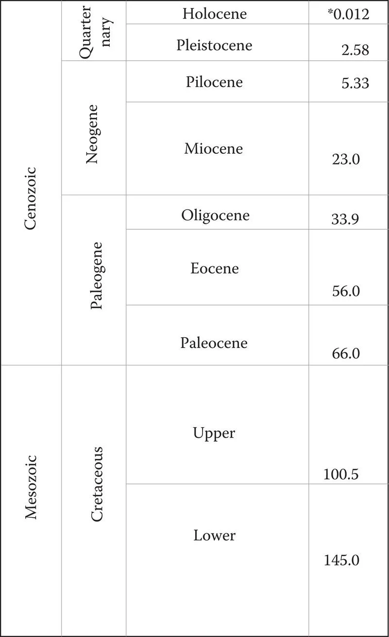
Over millions of years, those plants and animals have evolved. Because much of the area was underway early on, only one dinosaur bone has been found. An 80-million-year-old thigh bone of a therapod was found in 2015. However, about ten million years ago, the Olympic Mountains began to be uplifted, but much of Washington and even the peaks of the Cascades were under ice. A large number of mammal bones have been found from the Quaternary, including the Columbia mammoth, giant ground sloth, a rhinoceros relative called Diceratherium, bison, mastodons, and a whale relative called Chonecetus. In addition, many trilobites and ammonites have been found. Most of those large mammals are also long extinct (Figure 1.3).
Figure1.3 Geologic timeline. The various geologic eras will be referred to throughout much of the book.
The Puget Sound has a diverse ecology and has been home to a wide variety of plants and animals since its formation. For example, it is a major stop on the Pacific flyway for migrating and resident birds. Port Susan and Skagit Bay host more than 50,000 birds each winter. Snow geese, Dunlin sandpipers, yellowlegs, dowitchers, and many more feast on the amazing biomass in the mud and sand of the Sound.
Native Americans arrived in the region at least 10,000 years ago. They made their way from Asia during the last Ice Age when sea levels were lower than today, and the coast was 15–50 km west of where it is today. When that coldest part of the Ice Age ended, sea levels began to rise. Year after year, the tides were higher than those before. The ocean was creeping further and further onto the land. Those early Native Americans likely saw the ice cover of the last Ice Age recede and the water return to parts of the Puget Sound.
Sadly, natural systems have too often been the losers since humans arrived in the Sound region. In the last couple of hundred years, human activity has greatly influenced the Sound region, and much of that influence has not been for the better. Small towns have grown to become major cities, and the population continues to increase. More people means more stress on the natural environment to provide housing, transportation, and other systems in the region. Bridges, roads, ports, water and sewage systems and structures were built. Wetlands were filled and developed. Rivers were channeled and the shore was armored. In addition, human activities have introduced quite a number of invasive species that have disrupted natural populations and, in some cases, led to their extinction.
There is no magic wand to wave to restore the region to what it once was, but it is not all bad news. In more recent decades, people have come to realize that the natural habitat is important for people too. For too many years, the wetlands and the Sound have been treated like dumps for whatever waste the residents wanted to dispose of, or they were seen as ripe for development. Now efforts are underway to restore wetlands and other wild areas for the benefit of plants and animals, and also for humans.
Change is inevitable. In the crush of our daily activities, it's easy to forget that the forces that built the Sound are not influenced by our meetings, jobs, smartphones, or desires. They move at their own speed and come in their own time. The Sound was not always here, and it will not always be here in the future. The forces that created it are still active and will one day destroy it. Even now, we are feeling the effects of the climate crisis with much hotter temperatures and seemingly endless fire seasons. Sea levels are rising as the Earth's large icecaps and glaciers melt. That extra water will change the coastline and region over the next years.
We will describe the natural history and evolution of the Puget Sound region (e.g., its geology, plants and animals, people and their activities, and the connections among these) over the last 50 million years through the present and into the future. We will explain how those forces that built the Bay are still active today. Scientists have already made predictions of what might happen in the future. The most powerful are the geologic forces, and the region has been subjected to considerable tectonic activity over the years. Several faults crisscross the region and surrounding area, resulting in periodic earthquakes and other ground movements. Other forces include the rise and fall of the ocean with changes in climate, atmospheric rivers, and finally humans. Another Ice Age is not out of the question, but less likely. We will also review the predictions about the future of the Bay region and how those forces will eventually change the region beyond recognition. Humans witnessed the end of the Ice Age, the rise of sea levels, and the flooding of the Sound. We do not know if humans will see the end of the Sound, but we do know that change is coming.
References
Burke (nd) Welcome to the Puget Sound. The Burke Museum. Retrieved from: https://www.burkemuseum.org/static/FishKey/aboutps.html#:~:text=Over%2080%25%20of%20surface%20water,about%20Puget%20Sound%2C%20click%20here%20. March 20, 2021.
USGS (nd) Cascade Volcano Observatory. US Geologic Service. Retrieved from: https://www.usgs.gov/observatories/cascades-volcano-observatory. March 20, 2021.
2 Geological Origins of the Puget Sound
DOI: 10.1201/9780429487439-2
Building Western Washington
The Puget Sound is a relatively young estuary system. About 200 million years ago, the West Coast of North America was just west of Pullman and Spokane today. The western part of the state had its beginnings deep in the Pacific Ocean, and the forces that caused it to form are related to how the continents have formed and evolved over millions of years. Those forces include plate tectonics, volcanic activity, crustal uplift and depression, folding, and erosion. The result is a complex jumble. Interestingly, those forces are still active to...
Table of contents
Cover
Half Title
Title Page
Copyright Page
Contents
About the Authors
Chapter 1 Puget Sound Then and Now
Chapter 2 Geological Origins of the Puget Sound
Chapter 3 Water
Chapter 4 Geomorphology of Puget Sound
Chapter 5 Early Biology of Puget Sound
Chapter 6 Humans Arrive
Chapter 7 Puget Sound Today
Chapter 8 Biology of Puget Sound
Chapter 9 Protecting and Restoring Puget Sound
Chapter 10 Puget Sound in the Future
Index
Frequently asked questions
Yes, you can cancel anytime from the Subscription tab in your account settings on the Perlego website. Your subscription will stay active until the end of your current billing period. Learn how to cancel your subscription
No, books cannot be downloaded as external files, such as PDFs, for use outside of Perlego. However, you can download books within the Perlego app for offline reading on mobile or tablet. Learn how to download books offline
Perlego offers two plans: Essential and Complete
Essential is ideal for learners and professionals who enjoy exploring a wide range of subjects. Access the Essential Library with 800,000+ trusted titles and best-sellers across business, personal growth, and the humanities. Includes unlimited reading time and Standard Read Aloud voice.
Complete: Perfect for advanced learners and researchers needing full, unrestricted access. Unlock 1.5M+ books across hundreds of subjects, including academic and specialized titles. The Complete Plan also includes advanced features like Premium Read Aloud and Research Assistant.
Both plans are available with monthly, semester, or annual billing cycles.
We are an online textbook subscription service, where you can get access to an entire online library for less than the price of a single book per month. With over 1.5 million books across 990+ topics, we’ve got you covered! Learn about our mission
Look out for the read-aloud symbol on your next book to see if you can listen to it. The read-aloud tool reads text aloud for you, highlighting the text as it is being read. You can pause it, speed it up and slow it down. Learn more about Read Aloud
Yes! You can use the Perlego app on both iOS and Android devices to read anytime, anywhere — even offline. Perfect for commutes or when you’re on the go. Please note we cannot support devices running on iOS 13 and Android 7 or earlier. Learn more about using the app
Yes, you can access Making and Unmaking of Puget Sound by Gary C. Howard,Matthew R. Kaser in PDF and/or ePUB format, as well as other popular books in Physical Sciences & Ecology. We have over 1.5 million books available in our catalogue for you to explore.