The articulation between persistence and change is relevant to a great number of different disciplines. It is particularly central to the study of urban and rural forms in many different fields of research, in geography, archaeology, architecture and history. Resilience puts forward the idea that we can no longer be truly satisfied with the common approaches used to study the dynamics of landscapes, such as the palimpsest approach, the regressive method and the semiological analysis amongst others, because they are based on the separation between the past and the present, which itself stems from the differentiation between nature and society.
This book combines spatio-temporalities, as described in archeogeography, with concepts that have been developed in the field of ecological resilience, such as panarchy and the adaptive cycle. Thus revived, the morphological analysis in this work considers landscapes as complex resilient adaptive systems.
The permanence observed in landscapes is no longer presented as the endurance of inherited forms, but as the result of a dynamic that is fed by this constant dialogue between persistence and change. Thus, resilience is here decisively on the side of dynamics rather than that of resistance.
- English
- ePUB (mobile friendly)
- Available on iOS & Android
eBook - ePub
About this book
Trusted by 375,005 students
Access to over 1.5 million titles for a fair monthly price.
Study more efficiently using our study tools.
Information
PART 1
Landscape: Continuity and Transformation
Introduction to Part 1
Morphological analysis, the science or study of forms, first emerged in the 19th century. First used in biology, with respect to the external form and structure of living beings, and in linguistics, with respect to the different forms and rules governing the internal structure of words1, it is later used in the social sciences to describe functional structures and groups. In geography, history and architecture, the development of new representations of landscape, using planimetry, gave rise to a school of research based on morphological analysis. This approach was used across the domains of human geography, history and archeology, based on the shared idea that material or spatial realizations – or artifacts – cast light on social organizations.
The term form, derived from the Latin forma, which refers to both the “mold” and the “molded object”, concerns both the visible appearance of an object and that which gives it its shape. In this sense, it also relates to a “model to imitate” and may be understood as an “organization in accordance with a norm” (Rey 1993, p. 814). Form, thus, relates both to the appearance of organizations and to the organizing principle that underpins them (Chesneau and Roncayolo 2011, p. 156). The same ambiguity with respect to knowledge and ontology is also found in the word morphology, a term coined by Goethe in 1790. Originally used to refer to the study of the external configuration of an organ or living being, the term came to be used to refer to the actual form of living organisms (Rey 1993, p. 1275). Studying the prevailing practices in morphological analysis can tell us much about the way a society perceives a landscape and understands the way in which it marks this landscape, and consequently about the relationship between the society and its environment; the landscape is the result of this relationship. The nature of the relationship varies depending on the historical context, but also on the media used to perceive the landscape. Developments such as topographic cartography, in the late 19th century, aerial photography, in the wake of the First World War, and widespread archeological campaigns from the 1990s onwards all played a decisive role in the way in which researchers perceive and understand landscape forms.
The earliest studies of landscape forms adopted a diachronic approach, considering past and present in parallel; in the decades following the Second World War, however, a synchronic approach came to dominate the field. This approach is built around a strata-based framework where the present buries, and effectively cancels out, the past. Observations made in the course of rescue archaeology in the 1990s challenged this stratified vision of landscapes, highlighting the true complexity of temporalities, while increasingly strong cross-disciplinary connections between historians, archeologists and environmental specialists changed perceptions of the relationships between societies and environments. These developments formed the backdrop for a resurgence of interest in morphological analysis of historical landscapes, culminating in the emergence of a whole new discipline: archeogeography2. This approach promotes a vision of landscape in which the links between man and milieu play a key role, moving beyond the simple nature/culture division. In this first part, we shall consider the way in which past authors, from the late 19th century onward, envisioned the relationship between space and time in a landscape. We shall also explain why modern archeogeographers must move beyond the morphological analysis methods developed during this earlier period, demonstrating the need for a new and innovative theoretical framework.
- 1 https://www.cnrtl.fr/definition/morphologie, accessed July 24, 2020.
- 2 The French term is archeogeographie; in English, the term “landscape archeology” is also widespread.
1
Landscape: The Resistance of the Past?
1.1. The past in the present
1.1.1. Architectural and morphological persistences
Humanity has long been aware that certain constructions persist beyond the societies that shaped them. As early as the early Middle Ages, printed works and iconographic representations highlighted the presence of ancient constructions in the urban fabric of the city of Rome (D’Amico 2009). These constructions are presented as anchoring elements, ensuring that the city itself remained “eternal” (Djament-Tran 2011). Roads were also identified as permanent features of the landscape (D’Urban 1837, p. 415), and their continued presence is reflected in place names. The persistence of these roads was perceived locally by users well before Nicolas Bergier, a magistrate, made his first theoretical proposals in the early 17th century concerning the conditions under which these great ancient routes had survived the centuries (Bergier 1622).
By the late 19th century, scholars were well aware of the persistence of other, more extended and complex constructions in the landscape: town and city layouts, field patterns, village ground footprints and settlement patterns often followed agrarian structures established in the Middle Ages or even earlier. These elements attracted the attention of historians and legal specialists, philologists, geographers and architects from across the globe. This shared interest is partially explained by the development of increasingly detailed representations of space. Cartography made a significant leap forward at this time due to an increase in the precision of geodesic measurements and to new projection systems. Vast mapping campaigns were carried out over the course of the 19th century, establishing or updating national cartographic references by means of detailed surveys, at scales of 1:10,000, 1:40,000, etc. At the same time, cadastral surveys were carried out on an even larger scale: 1:1,250, 1:2,500, etc. (Steinberg 1982; Maurin 1992). Finally, the increase in the production and availability of travel guides provided further helpful tools for the first city and town planners, who were able to consult and compare existing layouts (Lavedan 1926a, p. 91).
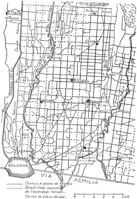
Figure 1.1. Reproduction of an ancient centuriation plan near Bologna, studied by the archaeologist Alfonso Rubbiani, from the 19th-century cartography in Albert Grenier’s Manuel d’archéologie gallo-romaine (Grenier 1934, p. 17)
This new documentation clearly showed the continued existence of ancient forms in the landscape. Concerning ancient planned plots in Campania, for example, the French archaeologist Albert Grenier indicated that the land “appeared to be” divided into square plots with a “very clear grid pattern”. He added that the most striking example was found in northern Italy (Figure 1.1) (Grenier 1934, p. 15). From the 19th century on, philological studies of texts relating to ancient surveying practices, whereby certain territories were divided along rectilinear lines intersecting at right angles into parcels or plots known as “limitations” or “centuriations” (centuriae),1 were compared with material traces. Using cross-analysis of topographic maps, cadastral records, aerial photographs and field observations in Italy, France, North Africa, the Near East, etc., historians attempted to reconcile the material traces with the texts (Chouquer 2008a).
1.1.2. Looking to the present to uncover the past: regressive history
In countries bearing fewer marks of Roman occupation, many researchers focused on medieval agrarian landscape structures. In 1895, August Meitzen, a professor of statistics and economics at the University of Berlin, posited that a type of land division that he had observed on cadastral plans was, in fact, the imprint of legal land plots established in late antiquity and the early Middle Ages (Meitzen 1895). Meitzen’s analytical method was widely disseminated, and historians began to pay increasing attention to cadastral plans as source materials. Inspired by Meitzen’s work, F.W. Maitland (1850–1906), professor of law at the University of Cambridge, began to study the origin of the grouped villages in the open field system and the dispersal of the English bocage. He stated: “Two little fragments of the original one-inch ordnance map will be more eloquent than would be many paragraphs of written discourse” (Maitland 1987, p. 16). Maitland’s work gave rise to a new ...
Table of contents
- Cover
- Table of Contents
- Title Page
- Copyright
- Acknowledgments
- Introduction
- PART 1 Landscape: Continuity and Transformation
- PART 2 Resilience: A Tool for Understanding the Dialectics of Persistence and Change
- PART 3 Synthesis: Landscape as a Resilient Social-ecological System
- Conclusion
- References
- Index
- End User License Agreement
Frequently asked questions
Yes, you can cancel anytime from the Subscription tab in your account settings on the Perlego website. Your subscription will stay active until the end of your current billing period. Learn how to cancel your subscription
No, books cannot be downloaded as external files, such as PDFs, for use outside of Perlego. However, you can download books within the Perlego app for offline reading on mobile or tablet. Learn how to download books offline
Perlego offers two plans: Essential and Complete
- Essential is ideal for learners and professionals who enjoy exploring a wide range of subjects. Access the Essential Library with 800,000+ trusted titles and best-sellers across business, personal growth, and the humanities. Includes unlimited reading time and Standard Read Aloud voice.
- Complete: Perfect for advanced learners and researchers needing full, unrestricted access. Unlock 1.5M+ books across hundreds of subjects, including academic and specialized titles. The Complete Plan also includes advanced features like Premium Read Aloud and Research Assistant.
We are an online textbook subscription service, where you can get access to an entire online library for less than the price of a single book per month. With over 1.5 million books across 990+ topics, we’ve got you covered! Learn about our mission
Look out for the read-aloud symbol on your next book to see if you can listen to it. The read-aloud tool reads text aloud for you, highlighting the text as it is being read. You can pause it, speed it up and slow it down. Learn more about Read Aloud
Yes! You can use the Perlego app on both iOS and Android devices to read anytime, anywhere — even offline. Perfect for commutes or when you’re on the go.
Please note we cannot support devices running on iOS 13 and Android 7 or earlier. Learn more about using the app
Please note we cannot support devices running on iOS 13 and Android 7 or earlier. Learn more about using the app
Yes, you can access Resilience by Sandrine Robert in PDF and/or ePUB format, as well as other popular books in Philosophy & Philosophy & Ethics in Science. We have over 1.5 million books available in our catalogue for you to explore.