![]()
CHAPTER ONE
ORIGINS
IN BRITISH COLUMBIA, it is hard to ignore geology. Most of us may not understand the rocks around us as well as we would like, but we are well acquainted with them—they stare at us from mountain cliffs and rugged shorelines every day.
If you were to take a flight across the province—say, from Jasper, Alberta, to Port Hardy on Vancouver Island—you would see a jaw-dropping variety of geological features. First come the sedimentary rocks of the glistening Rockies, rising abruptly above the forested plains. Next, the snowy peaks of the Cariboo Mountains rise up across the Rocky Mountain Trench, their crystalline rocks tortured by the heat and pressure of unimaginable forces beneath the surface of the earth. Now the broad Interior plateau comes into view, with its flat surface of poured lava surrounding the eroded valleys and canyons of the Fraser and Chilcotin Rivers. And finally, the shining white ice of Mount Waddington rises ahead, towering over the Coast Mountains’ choppy sea of granite. A more diverse flight can hardly be imagined, and this one has ignored the myriad of British Columbia’s geological wonders to the north and south.
In more ways than one, geology is the foundation of natural history. Geological formations not only form the physical base of terrestrial life and control the climate around it but also tell the temporal history of nature. Geology tells us how things came to be the way they are. Moving continents, rising and falling mountain barriers, vast volcanic eruptions and continental ice sheets all have played an essential role in creating the diversity of life in British Columbia today. Without a basic knowledge of geology, it is difficult to make sense of this diversity.
THE BUILDING OF BRITISH COLUMBIA: PLATE TECTONICS
British Columbia is part of the North American Cordillera—the mighty set of mountain ranges that stretch from northern Alaska to southern Mexico. This mountainous landscape arose through plate tectonic processes. Plate tectonics is how the earth works. Its crust and underlying relatively stiff upper mantle form a carapace of plates like the bones of a baby’s skull before they suture and lock together. The plates are constantly moving—some growing, some shrinking—at about the speed a fingernail grows. The key to the Cordillera is a long history of interactions between the western edge of the continent, the plates that make up the floor of the Pacific Ocean, and the small, mobile pieces of crust in between that have been created, that have evolved and that have shifted between ocean and land.
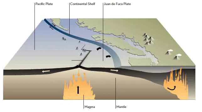
Our planet is unique in having plate tectonics. The constant swirling and recycling of the ocean’s rocky floor requires that the planet’s interior—like Goldilocks’s bowl of porridge—must be just right, not too hot and not too cold. Plate tectonics results from a balance between subduction—the sinking of oceanic plates at trenches like the modern Cascadia subduction zone off British Columbia’s west coast—and spreading at ocean ridges, where new crust is created by the rise of hot material in the earth’s mantle, as is happening at the Juan de Fuca Ridge a little farther west (Figure 1.1). The process of plate tectonics as we know it began sometime in Precambrian time. Exactly when is a matter of current discussion. But geologists agree that before then, the young earth was too hot and the plates were too buoyant to sink deep into the mantle. Eventually, the planet will cool to the point that the upward rise of mantle and melting of basalt to supply the ridges will fail—but we have billions of years left before that time. Meanwhile, the plates shift constantly, slowly, inexorably, building mountains while we sleep, only rumbling their intentions with earthquakes from time to time.
The modern North American continent is constructed like a chocolate-covered nut. At its core is an ancient continent, or craton, called Laurentia. Laurentia holds the record for the oldest rocks yet dated on earth, announced by Quebec researchers in 2008 as 4.28 billion years old. Compared with the craton, the rocks that make up the outer continent margin—including those of the Cordillera—are much younger, generally less than 700 million years. All of them have been added to the original continent. There are piles of sedimentary rock that once lay at its outskirts but rode up over it during periodic collisions. There are also continental fragments that had split from the continent but were later pushed back against it, parts of the margin that were dragged sideways by the motion of offshore oceanic plates. Some of the added pieces are actually crustal wanderers that crossed oceans to reach the western reach of the growing continent, and they play their role in building mountains there.
Not that Laurentia simply sat there, waiting for all this to happen. Its story, too, is that of a wanderer. It has been part of two supercontinents, and probably others before them, in the endless flamenco of approach and spurn, touch and turn away that has marked the earth’s rocky carapace ever since it formed. The breaking up of the Precambrian supercontinent Rodinia 750 to 550 million years ago did not create our Cordillera—that was many eons later—but it made the Cordillera possible. Without that breakup, Laurentia would have lain serenely within a vast continental interior: a prairie, perhaps, or a vast plain of lakes and wetlands, its smooth, low surface unbroken by even a dream of mountains.
But as it happened, towards the end of Precambrian time, a rift formed in what is now southern British Columbia, one of the many that fragmented the world continent Rodinia into many pieces. Whatever was on the other side of that rift—Australia, Antarctica and Siberia each has its advocates—moved slowly and stately away to the west. The Pacific Ocean was born, and the whole tectonic drama of Cordilleran evolution could begin.
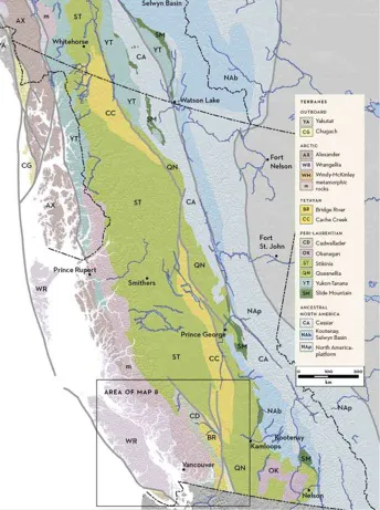
The Cordilleran terranes are pieces of once-mobile crust that make up much of the Cordillera, extending west to the Pacific Ocean from an eastern edge in the Omineca Mountains. On Map 1 you see them divided into realms, according to their origins. The peri-Laurentian terranes lie between the Omineca Mountains and the western Coast Mountains and underlie the Intermontane region in between. They once were the bedrock of arc-shaped chains of volcanic islands and small oceans that lay west of the old continent, in a complex and evolving geography comparable with the other side of the Pacific Ocean basin today. Think of Japan, perhaps, or the Philippines. One of the ancient island arcs is named Quesnellia, after the town of Quesnel. It runs from there north to the Yukon border east of Teslin Lake and south past Princeton. The other old island arc, Stikinia, spans western British Columbia from Bella Coola to Atlin. Island arcs form above subduction zones. Their volcanoes build from lavas and explosive volcanic deposits that originate as melts of the subducted plate as it plunges down into hotter and hotter mantle.
FIGURE 1.1: The plate tectonic setting off the coast of British Columbia today. Magma from the earth’s mantle rises upward along the Juan de Fuca Ridge, cooling to form new ocean floor. The walls of the ridge are pulled apart by the same convection currents, and the Pacific Plate and the Juan de Fuca Plate grow symmetrically on either side of the ridge. Where the latter plate encounters westward-moving North America, it slides beneath the continental shelf and descends into the mantle. When it reaches depths of 150 to 100 kilometres, the plate partly melts again, and the resulting magma rises up to reappear as the volcanoes of the Cascade-Garibaldi Arc—among them Mount Meager, Mount Garibaldi, Mount Baker, Mount Rainier and Mount St. Helens. Adapted from C. J. Yorath, Where Terranes Collide, p. 123.
Parts of these volcanic island chains were founded on rifted fragments of Laurentia (to imagine a rifted fragment, think of California west of the San Andreas Fault—this piece of the continent is being pushed inexorably north and will eventually sail past the west coast of British Columbia). The Slide Mountain terrane is the Late Paleozoic seafloor of a minor ocean that grew between one of these rifted chunks and the mother continent. It is spectacularly exposed in the Cassiar Mountains of far northern British Columbia, forming dark peaks of basalt and deep-water sediments where it now rests atop the pearl-grey limestones of western Laurentia. It is as if the floor of today’s Sea of Japan, a small ocean that for the last 20 million years or so has been widening between Japan and mainland Asia, were to be shoved back up on top of Korea, and then the whole pile uplifted and carved into mountains.
Compared with the relatively local peri-Laurentian terranes, those of the Tethyan and Arctic realms have travelled astounding distances to arrive in their present Cordilleran berths. Among the many lines of evidence for their exotic origins, fossils are one of the most compelling. The Cache Creek terrane forms a discontinuous strip in the British Columbia Interior, surrounded to the east, north and west by more local peri-Laurentian terranes. Its southern exposures can be seen around Cache Creek and Clinton and as far west as the white limestone bluffs of Marble Canyon. On the drive north of Cache Creek on Highway 97, some of the nearby low hills are made of curiously bare, crumbly, dark green to blue-green scree. This is serpentinite, a rock that once made up the deep mantle underpinnings of oceanic crust. Serpentine is a stone that grows little moss, and still less complex forms of vegetation. Compared with continental crust, which has benefited from the distillation of nutrients in generations of magmas and of sedimentary cycles, mantle is a poverty-stricken substrate composed of silica, magnesium, iron, nickel, cobalt and precious little else. Few plants can survive in its nutrient-poor soils. But its presence here delights the geologist, because its exhumation from deep mantle to grassland demonstrates a powerful process of planet-scale plate motion and, more specifically, a dramatic collision of an oceanic plate with the continent.
MAP 1: TERRANES
The pieces of the earth’s crust that have come together to form British Columbia are grouped here according to their origins. Terrane groupings are explained in the text and in Maps 2–7.
If you were to look closely at the limestones around Marble Canyon you would find, along with corals, some unassuming little fossils that look like fat grains of wheat. They are fusulinids, a now-extinct family of foraminifera (shelled amoeboid organisms) that flourished in warm Late Paleozoic seas. The youngest Marble Canyon fusulinids are Late Permian, and some are of the genus Yabeina. These small foreign creatures have no known relatives in or near Laurentia, but they and all their cousins can be found in their billions in the Permian limestones of China and Japan. In Permian time, long before the continental collisions that drove the Alps and Himalayas skyward, a bend of ocean called the Tethys lay surrounded by Europe, Siberia, Africa, India and Antarctica, with the continental fragments that now make up China on its east. Yabeina grew prolifically there. The Marble Canyon limestones are thought to have been reefs built on an ocean island somewhere on that side of the Pacific. After that, the island must have become entrained in an eastward-moving oceanic plate, reeled towards the Laurentian margin by rapid subduction under its fringing island arcs, Stikinia and Quesnellia.
Outside and west of the peri-Laurentian terranes in British Columbia lie the Insular terranes, Wrangellia and the Alexander terrane—the bedrock of Vancouver Island, Haida Gwaii (the Queen Charlotte Islands) and the islands of the Inside Passage. These rocks are also exotic but probably with an entirely different origin than that of the Cache Creek terrane: they once were part of the Arctic realm. Their older parts formed and evolved somewhere near northern Scandinavia and eastern Siberia until in mid-Paleozoic time, when they were propelled westward through the Arctic Ocean and into the Pacific. Again, some of the key evidence is fossils. For instance, some unusual early Paleozoic sponges (480 to 420 million years ago) are found in the Alexander terrane on Prince of Wales Island in southeastern Alaska just north of Prince Rupert. Other than the Alexander terrane, these particular sponges are found only in terranes of northwestern Alaska and Oregon, and in the southern Ural Mountains.
The transport of the Arctic and Insular crustal fragments westward across the Arctic seaway left its traces in glancing mid-Paleozoic collisions recorded in the rocks of the Canadian Arctic Islands and the Brooks Range of northern Alaska. Unlike the ocean floor that ferried the Cache Creek ...