Whether planning a day sail or a longer passage, at home, at the wheel or at the chart table, the Skipper's Cockpit Navigation Guide is the perfect at-a-glance handbook for all skippers and crew. It covers all the essential navigation skills and techniques with a user friendly, easy to follow and succinct approach. Spiral bound to lie flat, and with laminated splash-proof pages, it is the hands-free ready reckoner to help you get where you want to go.
Written in clear, practical language, with clear photos, step-by-step diagrams and actual chart extracts, the book covers:
- Using nautical charts
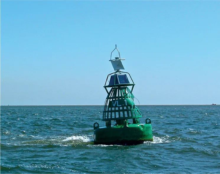
- Understanding buoys, marks and lights
- Using the compass, log and depth gauge
- Plotting positions (including by dead reckoning), courses and bearings
- Understanding tides (heights, streams, including using tide tables) and currents
- Factoring in the weather
- Making a passage plan, keeping a logbook, and more
An essential title to have on board, this accessible book is aimed at skippers and crews of all levels, whether as a primer for those new to navigating or the perfect aide-memoire for those with prior experience.

- 24 pages
- English
- ePUB (mobile friendly)
- Available on iOS & Android
eBook - ePub
Skipper's Cockpit Navigation Guide
About this book
Trusted by 375,005 students
Access to over 1.5 million titles for a fair monthly price.
Study more efficiently using our study tools.
Information
RECKONING
Position fixing
Nowadays, the position of a ship can be continuously read on a device such as a GPS receiver, plotter or tablet. Should these electronics fail due to battery or power problems, the navigator must be able to fall back on two traditional methods of determining position: estimation and position fixing. By the way, the easiest way to determine a position is simply to sail close to a mark and read the identifying marks! Regardless of how a position is obtained, it must be entered on the chart at regular intervals (at least once an hour) in accordance with a fixed notation, including the time of observation.
Dead reckoning
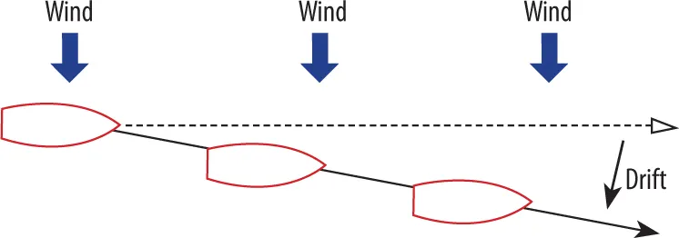
In the absence of visible marks, the position is calculated from the last known position based on course and speed, corrected for leeway caused by the wind and tidal current. The method requires considerable calculation. The speed through the water is read from the log (see here). The angle of leeway can be estimated by plotting a line behind the ship and taking a bearing in relation to the keel line. The influence of the current on the course and speed is deduced from the data in the tidal atlas or on the nautical chart by means of vector calculations.
Visual fixes
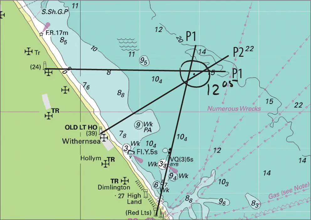
By using a hand-bearing compass to determine the direction of marks and objects on the nautical chart, it is easy to plot the position on the chart. Depending on the situation, there are several possibilities. For all bearings, the compass bearing has to be converted to the magnetic bearing (deviation) and then to the true or chart bearing (variation) before drawing it on the chart. A cross fix is a bearing on two or more objects. The best results are obtained where the angle between the selected objects is approximately 90° from the boat’s position.

Position according to dead reckoning

Position by estimation
Position by bearing or GPS
© British Crown Copyright
Three-point fix
Running fix

Double line bearing

Bearing with depth measurements
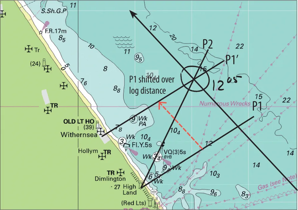
A running fix involves plotting two bearings of an object, with a time interval and notation of the log position at both bearings. The second bearing is taken when the angle of view is about 60° to the first bearing. By shifting the first bearing on the chart over the covered distance, a cross fix is created. The accuracy depends largely on the accuracy of the steered course and a correct estimation of leeway and current.
A useful variation on this is the double line bearing (for areas without current) with two measurements on a single object. The first bearing is at a small angle between the course and the object, for example 35°. The second is at (exactly) twice that, 70°. The difference in the log positions is adjusted on the second bearing and results directly in the position.
A fix can be achieved by combining a bearing of one object with a depth measurement (see here). Only in areas with a sufficiently distinctive bottom profile is this bearing reasonably reliable and tidal height calculations are necessary.
Electronic sight reading
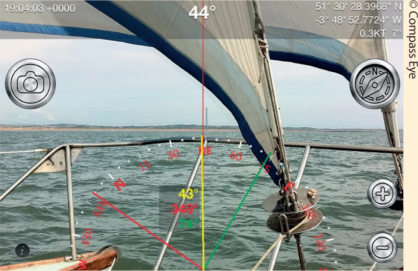
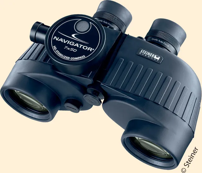
Many professional binoculars are equipped with an (electronic) bearing compass, sometimes in combination with a range finder, which greatly simplifies the observation and measurement of both fixed and moving objects. The iPad’s camera can also be used to take cross bearings; the Compass Eye app remembers three bearings and, if necessary, plots them on Google Earth.
DEPTH
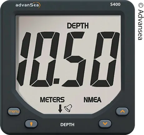
The current water depth (see here) determines whether a planned route can actually be used. With the help of an electronic depth gauge, it is possible to monitor the water depth continuously. Having adjusted for the vessel’s draught (keel offset) an alarm can be set to sound at a selected safety level.
Depth sounder
Depth sounders for yachts use ultrasonic sound waves. The instrument measures the time between the emission of a sound pulse and the reception of th...
Table of contents
- Cover
- Contents
- Charts
- Buoys, Marks & Lights
- Using a Compass
- Tides & Currents
- Log & Depth Gauge
- Passage Planning
- eCopyright
Frequently asked questions
Yes, you can cancel anytime from the Subscription tab in your account settings on the Perlego website. Your subscription will stay active until the end of your current billing period. Learn how to cancel your subscription
No, books cannot be downloaded as external files, such as PDFs, for use outside of Perlego. However, you can download books within the Perlego app for offline reading on mobile or tablet. Learn how to download books offline
Perlego offers two plans: Essential and Complete
- Essential is ideal for learners and professionals who enjoy exploring a wide range of subjects. Access the Essential Library with 800,000+ trusted titles and best-sellers across business, personal growth, and the humanities. Includes unlimited reading time and Standard Read Aloud voice.
- Complete: Perfect for advanced learners and researchers needing full, unrestricted access. Unlock 1.5M+ books across hundreds of subjects, including academic and specialized titles. The Complete Plan also includes advanced features like Premium Read Aloud and Research Assistant.
We are an online textbook subscription service, where you can get access to an entire online library for less than the price of a single book per month. With over 1.5 million books across 990+ topics, we’ve got you covered! Learn about our mission
Look out for the read-aloud symbol on your next book to see if you can listen to it. The read-aloud tool reads text aloud for you, highlighting the text as it is being read. You can pause it, speed it up and slow it down. Learn more about Read Aloud
Yes! You can use the Perlego app on both iOS and Android devices to read anytime, anywhere — even offline. Perfect for commutes or when you’re on the go.
Please note we cannot support devices running on iOS 13 and Android 7 or earlier. Learn more about using the app
Please note we cannot support devices running on iOS 13 and Android 7 or earlier. Learn more about using the app
Yes, you can access Skipper's Cockpit Navigation Guide by Rene Westerhuis in PDF and/or ePUB format, as well as other popular books in Technology & Engineering & Aviation. We have over 1.5 million books available in our catalogue for you to explore.