When German forces occupied the coastline of the English Channel in 1940, one of the measures undertaken to give early warning of attacks from the sea or air was to set up a line of radar stations. Although this invisible screen was a passive defense, it was a serious 'barrier' that had to be neutralized for the Allied invasion to be launched in 1944. Planners at RAF Medmenham had established there the Central Interpretation Unit (CIU) to examine the results of aerial photography over the Continent and the unit prepared plans of every enemy radar site ready for briefing pilots undertaking pre-invasion attacks. Those once-secret plans are now reproduced in this book, alongside the wartime photography, with comparison views of the sites today. Where farmland has now reclaimed the sites little remains to be seen, but on others there are still significant traces of a once-powerful weapon in the German armory. To set the scene, Professor R. V. Jones, the Assistant Director of Intelligence at the Air Ministry, recounts the events leading up to the proposal to mount a raid on the radar site at Bruneval. The site had what became known as a 'Würzburg' and the idea was to dismantle and remove the critical parts of the unit to bring then back to Britain and, hopefully, at the same time capture the operators for interrogation.
- 192 pages
- English
- ePUB (mobile friendly)
- Available on iOS & Android
eBook - ePub
About this book
Trusted by 375,005 students
Access to over 1.5 million titles for a fair monthly price.
Study more efficiently using our study tools.
Information
Subtopic
European HistoryIndex
History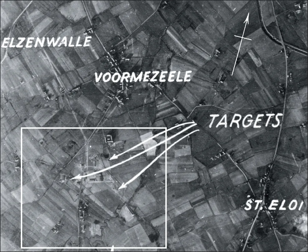
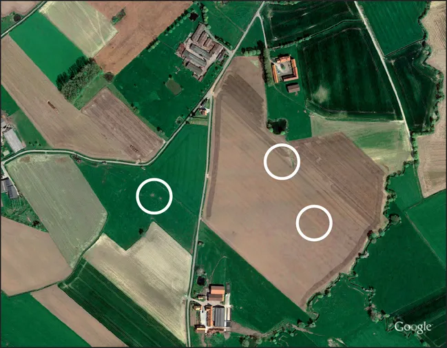
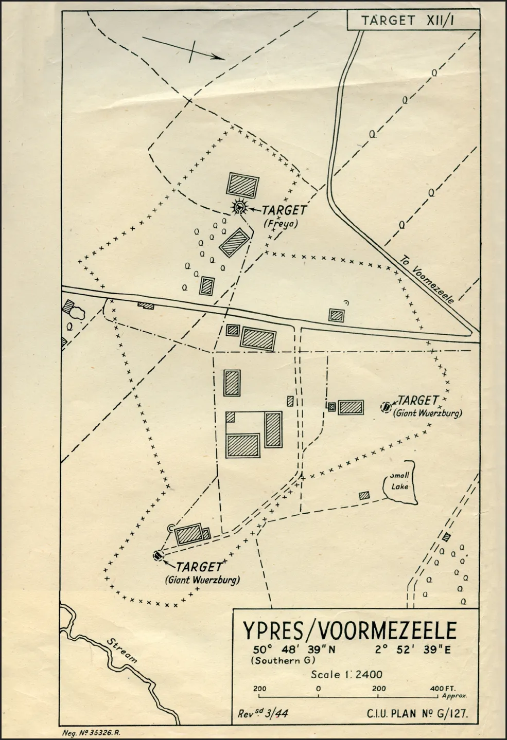
The co-ordinates given on the plan for Target XII/I is for the position of one of the Giant (or Riese) Würzburgs. The site lay east of the N331, south of Ypres, on what is now open farmland.
YPRES/VOORMEZEELE
GROUND CONTROL INTERCEPTION STATION
Co-ordinates: 50° 48’ 39”N 2° 52’ 39” E
Grid reference: 579568
Altitude: 90ft
The site is about three miles south of Ypres and half a mile south of the village of Voormezeele, in fields interspersed with small patches of woodland.
Target consists of two Giant Würzburgs and a Pole-type Freya apparatus, five large rectangular mounds formed by wide earth blast-walls, and a rectangular hut at the centre. Distance between the Würzburgs is 292 yards. Near the Freya are several buildings covered with camouflage material, while among the farm buildings 360 yards south of the two Würzburg sites, and adjoining the road, is a semi-sunken building.
The site is surrounded by wire, and opposite the farm buildings is a slit trench leading to a weapon pit, and a similar trench and pit are in evidence near the southern Würzburg, from which an underground cable trench runs to the road. Photo taken December 30, 1943.
Note that the map (opposite) is turned sideways with north on the right.
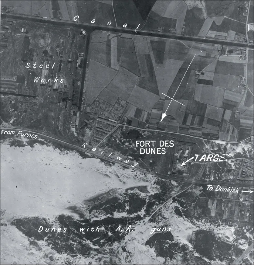
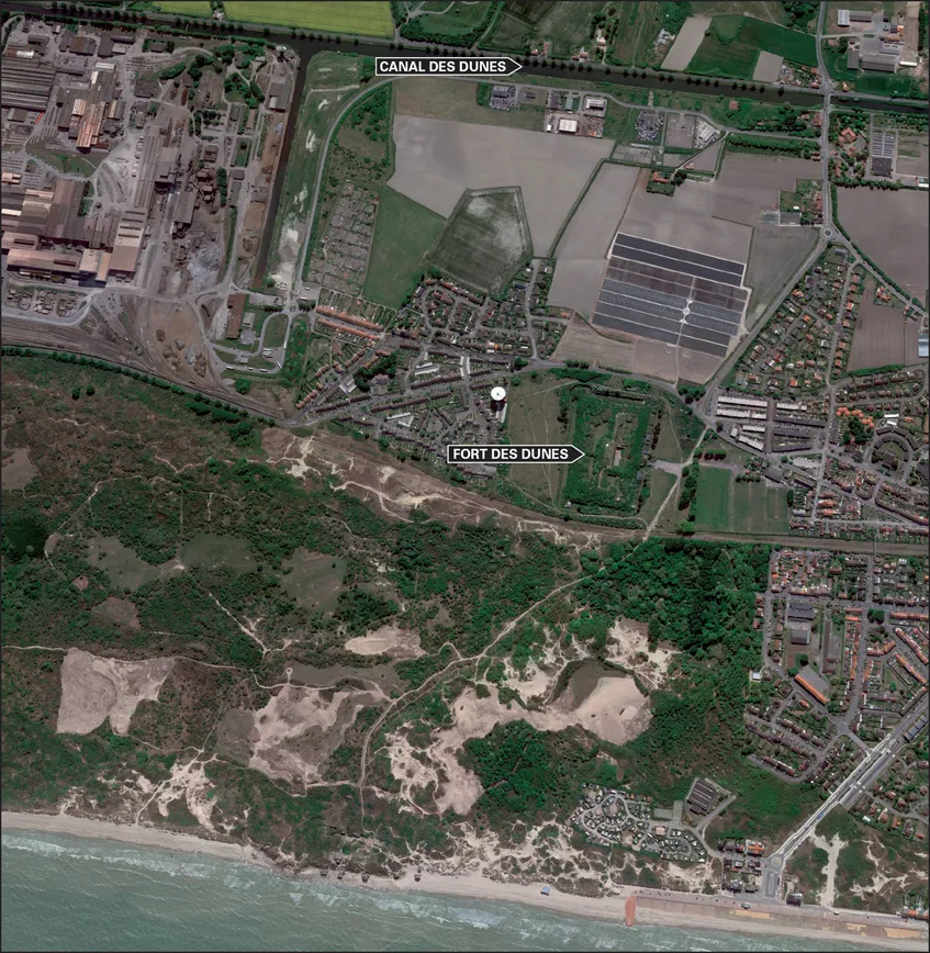
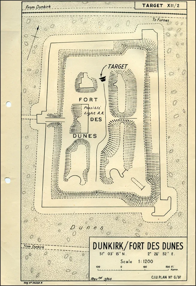
Target XII/2 was located in a 19th century French fortification which backed on to the dunes three miles east of Dunkirk. Its German code-name was ‘Dahlie’.
DUNKIRK/FORT DES DUNES
COASTAL SHIP-WATCHING STATION
Co-ordinates: 51º 03’15”N 2º 26’ 52” E
Grid reference: 296857
Altitude: 20ft
This coastal station is sited on the northern ramparts of the Fort des Dunes, an old fort about ½ mile inland from the sea-front at Zuydcoote, and approximately three miles east-northeast of Dunkirk.
The target consists of a single Giant Würzburg.
Defence positions exist at the fort and these do not appear to have been added to.
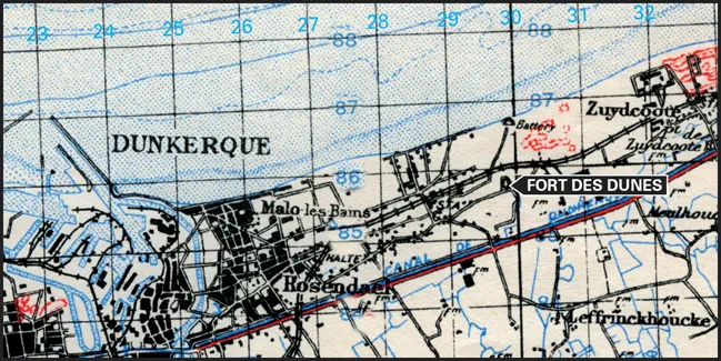
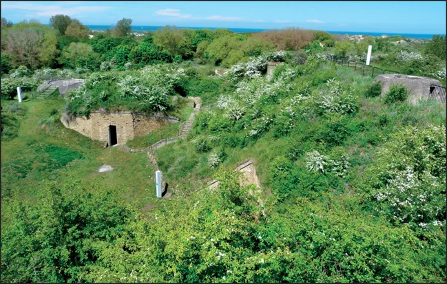
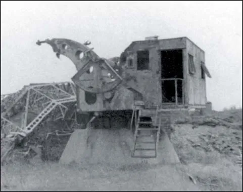
Originally known as the Fort de l’Est, it was built between 1878 and 1880 at the same time as the Zuydcoote Battery some distance to the north, to protect Dunkirk and its port from attacks from the east. Part of the Séré de Rivières system, it was armed with a variety of weaponry and manned by a garrison of 450 men. Being far behind the lines, it saw no action during the 1914-1918 war but it was a different story in the Second World War. On June 2, 1940, the Luftwaffe bombed the fort where the headquarters of the 12ème Division d’lnfanterie Motorisée was then established, killing Général Louis Janssen, the commander of the division, and several of his staff. Another aerial attack on June 3 caused more deaths and damage, bringing the total losses to artillery and aerial bombing to over 150. The northern part of the fort, with the hexagonal base for the Würzburg Giant radar is visible top right.
As soon as the last evacuations had taken place from the Dunkirk beaches and port on June 4, the Germans took possession. Once the access bridge broken by a Stuka bomb had been repaired, the fort became an annex to the nearby Zuydcoote Battery. The Germans set up a theatre in the old powder magazine in the Fort des Dunes, and the wooden stage they built is still visible today, as well as a nice fresco inspired by the famous movie Metropolis.
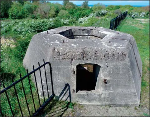
Another highlights of the visits is the concrete base of the Giant Würzburg.
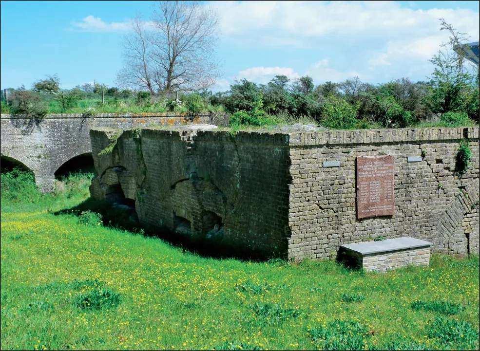
On September 4, 1944, one young member of the Resistance attempted to intercept a lone German soldier in nearby Rosendaël, seemingly to capture his rifle. The attempt failed but the Germans quickly traced the house where the assailant escaped. They assaulted the house and arrested eight men hiding there, one of them being wounded by a grenade during the operation. They were first taken to the Zuydcoote Battery where one of them, Daniel Decroos, was killed when he tried to escape. The seven men were then taken to the fort to be executed on September 6 in the northern ditch. The wounded man was also put to death. The Dunkirk Pocket held out until the final surrender in May 1945. In the summer, wrecks of collapsed masonry were searched in the northern ditch to recover the remains of the executed men and after a ceremony on August 6, 1945, they were re-interred in various family graves. Later more excavations were carried out to trace the remains of those who had been killed in the bombing in 1940 and all were re-interred in a military cemetery just north of the fort entrance; the cemetery now comprises 190 graves. Bought in 1998 by the commune of Leffrinckoucke the fort was cleared and restored and open to visits from 2010. The Fort des Dunes is now open to visits from February to November.
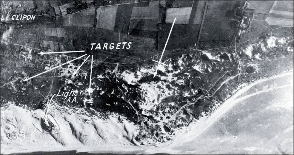
Target XII/3 lay some six miles down the coast from Dunkirk at Gravelines. Today the town is better known as the site of the largest nuclear power station in western Europe. This is made up of six reactors, each producing 900 megawatts, which equates to more than eight per cent of the whole of the electricity produced in France. The cooling water is discharged into the English Channel.
GRAVELINES/LE CLIPON
AIRCRAFT REPORTING STATION
Co-ordinates: 51º 01’ 34”N 2º 12’ 25”E
Grid reference: 125839
Altitude: 20ft
Situated on a high point in the dunes between Gravelines and Dunkirk, on the seaward side of the minor road from Gravelines to Le Clipon. Mardick airfield lies less than two miles the east.
The radar station is manned by elements of the Marine-Artillerie-Abteilung 204.
The target consists of two Giant Würzburgs, one small Würzburg and two Pole-type Freya ...
Table of contents
- Cover
- Title
- Credits
- Acknowledgements
- Editorial Note
- Contents
- Introduction — BRUCE ROBERTSON
- The Bruneval Raid— ALFRED PRICE
- Operations Against Coastal Radar Stations — R. V. JONES
- Ypres/Voormezele (Target No. 1)
- Dunkirk/Fort des Dunes (Target No. 2)
- Gravelines/Le Clipon (Target No. 3)
- Gravelines/Petit-Fort-Philippe (Target No. 4)
- Cap Blanc-Nez (Target No. 5)
- Cap Blanc-Nez/St Pol (Target No. 6)
- Cap Gris-Nez (Target No. 7)
- Cap Gris-Nez/Pointe du Riden (Target No. 8)
- Cap Gris-Nez/Bellevue (Target No. 9)
- Cap Gris-Nez/Wattermel St George (Target No. 10)
- Cap Gris-Nez/Onglevert (Target No. 11)
- Boulogne/Boursin (Target No. 12)
- Boulogne/Monument (Target No. 13)
- Boulogne/Mont Lambert (Target No. 14)
- Boulogne/Cap d’Alprech (Target No. 15A)
- Boulogne/Cap d’Alprech (Target No. 15B)
- Boulogne/Hardelot (Target No. 16)
- Mont Violette (Target No. 17)
- Neufchâtel/Mont St Frieux (Target No. 18)
- Le Touquet/Plage Ste Cécile (Target No. 19)
- Fruges/Prédefin (Target No. 20)
- Aubigny/Frévillers (Target No. 21)
- Berck-sur-Mer (Target No. 22)
- Cayeux/Nouveau Brighton (Target No. 23)
- Amiens/Montrelet (Target No. 24)
- Abbeville/Vaudricourt (Target No. 25)
- Le Tréport/Mont Huon (Target No. 26)
- 101 Dieppe/Caude-Côte (Target No. 27)
- St Valéry-en-Caux/Manneville-ès-Plains (Target No. 28)
- St Valéry-en-Caux/St Martin-aux-Buneaux (Target No. 29)
- Fécamp/Chapelle de la Vierge (Target No. 30)
- Cap d’Antifer/Sémaphore (Target No. 31)
- Cap d’Antifer (Target No. 32)
- Yvetot/Épinay-sur-Duclair (Target No. 33)
- Neufchâtel/Sully (Target No. 34)
- Le Havre/Cap de la Hève (Target No. 35)
- Lisieux/Le Theil-Nolent (Target No. 36)
- Bernay/La Chalière (Target No. 37)
- Houlgate/Sémaphore (Target No. 38)
- Caen/Douvres-la-Délivrande (Target No. 39)
- Arromanches (Target No. 40)
- Pointe et Raz de la Percée (Target No. 41)
- St Lô/Bourg d’Enfer (Target No. 42)
- Vire/Le Parc (Target No. 43)
- Barfleur/Le Vicel (Target No. 44)
- Cherbourg/Cap Lévy (Target No. 45)
- Cherbourg/Fermanville (La Brasserie) (Target No. 46)
- Omonville la Rogue/Asselins (Target No. 47)
- Cap de la Hague/Auderville (Target No. 48)
- Cap de la Hague/Jobourg (Target No. 49)
- Cap de Carteret/Sémaphore (Target No. 50)
- Guernsey/Fort George (Target No. 51)
- Guernsey/Pleinemont (Target No. 52)
- Jersey/Rouge Nez (Target No. 53)
- St Malo/Pointe du Grouin (Target No. 54)
- Cap Fréhel/Sémaphore (Target No. 55)
- Moncontour/Bel-Air (Target No. 56)
- Loudéac/La Récompense (Target No. 57)
- Monterfil/Les Épinais (Target No. 58)
- Vitré/La Haye (Target No. 59)
- Oisseau/Marêtre (Target No. 60)
- Falaise/Ri (Target No. 61)
- Dieppe/Ste Marguerite (Target No. 62)
- St Valéry-en-Caux/St Léger (Target No. 63)
- Bayeux/Le Mesnil (Target No. 64)
- Calais/Sangatte (Target No. 65)
- Postscript
Frequently asked questions
Yes, you can cancel anytime from the Subscription tab in your account settings on the Perlego website. Your subscription will stay active until the end of your current billing period. Learn how to cancel your subscription
No, books cannot be downloaded as external files, such as PDFs, for use outside of Perlego. However, you can download books within the Perlego app for offline reading on mobile or tablet. Learn how to download books offline
Perlego offers two plans: Essential and Complete
- Essential is ideal for learners and professionals who enjoy exploring a wide range of subjects. Access the Essential Library with 800,000+ trusted titles and best-sellers across business, personal growth, and the humanities. Includes unlimited reading time and Standard Read Aloud voice.
- Complete: Perfect for advanced learners and researchers needing full, unrestricted access. Unlock 1.5M+ books across hundreds of subjects, including academic and specialized titles. The Complete Plan also includes advanced features like Premium Read Aloud and Research Assistant.
We are an online textbook subscription service, where you can get access to an entire online library for less than the price of a single book per month. With over 1.5 million books across 990+ topics, we’ve got you covered! Learn about our mission
Look out for the read-aloud symbol on your next book to see if you can listen to it. The read-aloud tool reads text aloud for you, highlighting the text as it is being read. You can pause it, speed it up and slow it down. Learn more about Read Aloud
Yes! You can use the Perlego app on both iOS and Android devices to read anytime, anywhere — even offline. Perfect for commutes or when you’re on the go.
Please note we cannot support devices running on iOS 13 and Android 7 or earlier. Learn more about using the app
Please note we cannot support devices running on iOS 13 and Android 7 or earlier. Learn more about using the app
Yes, you can access German Coastal Radar Stations by Winston Ramsey,Jean Paul Pallud in PDF and/or ePUB format, as well as other popular books in History & European History. We have over 1.5 million books available in our catalogue for you to explore.