Groundwater for Sustainable Livelihoods and Equitable Growth explores how groundwater, often invisibly, improves peoples' lives and livelihoods. This unique collection of 19 studies captures experiences of groundwater making a difference in 16 countries in Africa, South America and Asia. Such studies are rarely documented and this book provides a rich new collection of interdisciplinary analysis. The book is published in colour and includes many original diagrams and photographs.
Spring water, wells or boreholes have provided safe drinking water and reliable water for irrigation or industry for millennia. However, the hidden nature of groundwater often means that it's important role both historically and in the present is overlooked. This collection helps fill this knowledge gap, providing a diverse set of new studies encompassing different perspectives and geographies. Different interdisciplinary methodologies are described that can help understand linkages between groundwater, livelihoods and growth, and how these links can be threatened by over-use, contamination, and ignorance.
Written for a worldwide audience of practitioners, academics and students with backgrounds in geology, engineering or environmental sciences; Groundwater for Sustainable Livelihoods and Equitable Growth is essential reading for those involved in groundwater and international development.
Trusted by 375,005 students
Access to over 1.5 million titles for a fair monthly price.
Chapter 1Groundwater and livelihood in Gunungsewu karst area, Indonesia
E. Haryono, T.N. Adji, A. Cahyadi, M. Widyastuti and U. Listyaningsih
Universitas Gadjah Mada
E. Sulistyowati
UIN Sunan Kalijaga
DOI: 10.1201/9781003024101-1
CONTENTS
1.1 Introduction
1.2 Hydrogeology and water resource situation
1.3 Groundwater extraction and water supply development
1.4 Livelihood and water scarcity adaptation strategy
1.4.1 Living condition and adaptation strategy
1.4.1.1 Seasonal crop farming
1.4.1.2 Agroforestry
1.4.1.3 Livestock raising
1.4.1.4 Migration
1.4.1.5 Groundwater-related tourism
1.4.2 Water consumption pattern
1.5 Impact of water supply development
1.6 Summary
Acknowledgments
References
1.1 Introduction
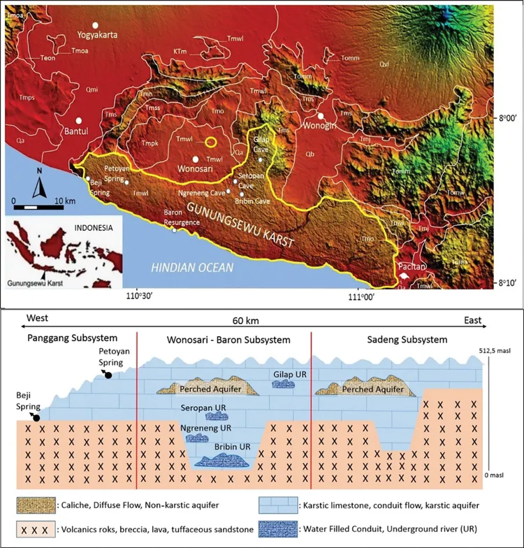
Gunungsewu karst covers 1,300 km2, extending 84 km from Parangtritis Beach, Bantul Regency-Special Province of Yogyakarta to Telengria Beach, Pacitan Regency – East Java Province (Figure 1.1). This area comprises the Wonosari-Punung Formation, a Neogen Limestone composed of massive coral limestone and bedded chalky limestone. The basement of the limestone formation is mostly a Miocene volcanic clastic sedimentary rocks of Wuni Formation, Sambipitu Formation, Semilir Formation, Nglanggran Formation, and Nampol Formation (Table 1.1).
Figure1.1 Gunungsewu Karst area, depicted in the SRTM image with stratigraphic units. (Crossed section (no scale) is modified from Kusumayudha (2015), showing the basement rock structure governing the main underground river system of the area. Stratigraphic units are extracted from the Geological map of Yogyakarta and Surakarta Quadrangle (Surono et al., 1992; Rahardjo et al., 1995). Springs and underground river extraction sites are shown in the figure in a small solid white circle.)
Table1.1 Geological formation in Gunungsewu karst area and its surrounding
Geological formation
Description
Wonosari-Punung formation (Tmwl)
Bedded limestone, massive limestone, and reefs
Quartenary alluvium (Qa)
Alluvium
Baturetno formation (Qb)
Quaternary deposits, consisting of sand, gravel, clay (dominated by black clay)
Lawu volcanic rock (Qvl)
Tuff and volcanic breccia, andesitic lava
Merapi volcanic rock (Qmi)
Tuff and volcanic breccia, lava, Lahar deposits
Nglanggran formation (Tmn)
Volcanic breccias, agglomerates and several basaltic andesite intrusions, pillow lavas
Semilir formation (Tms)
Andesitic tuffs, sandstones, agglomerates, claystone, siltstone, shale, and andesitic to basaltic breccias
Bemmelen formation (Tmoa)
Andesite
Jaten formation (Tmj)
Quarzt sandstone, tuffaceous sandstone, shale
Watu Patok formation (Tomw)
Lava, intercalation of sandstone, claystone, chert
Oyo formation (Tmo)
Mixed marine-volcanic facies of very well bedded tuffaceous marl, clays, andesitic tuffs, conglomeratic limestones
Metamorphic rock (Ktm)
Schist, marble, meta volcanic rock, metasediment, slate
Source: Compiled from Surono et al. (1992) and Rahardjo et al. (1995).
The karst of the Gunungsewu karst area has conical/Kegel karst morphology with cockpit-type closed depression (Haryono and Day, 2004; Tjia, 2013). The cockpit is the area where people are inhabiting and growing crops for staple food (Haryono et al., 2016). The prevailing climate of the area is monsoon, with annual precipitation from 1,600 to 2,000 mm. Unfortunately, the people of these areas are suffering from water shortages due to difficult access to surface and groundwater resources. Most of the rainwater sinks to the underground through ponors and sinking streams. The underground rivers are at a depth of 60–100 m or more and are found only in a few places. Therefore, local people neither have access to the groundwater nor are they able to make their own water supply system. Even, the local government and water supply companies facing difficulties in providing water supply. The government is still exploring the possible new caves with underground rivers in search of water supply.
Surface water is available as doline ponds (telaga) and springs. The ponds occur when the ponors are clogged by clayed sediment in the base of cockpits. However, most of the doline ponds are drying up due to deforestation, sedimentation, and leakages (Haryono et al., 2009; Widyastuti and Haryono, 2016). But karst springs emerge only in some localities and fulfill only the water supply for the surrounding villages. Therefore, the primary water source is groundwater as an underground river. Four caves with underground rivers are already in use for water supply, i.e., Seropan, Bribin, Ngobaran, and Baron. However, the water supply is not able to meet water demand for the whole karst area.
Villages are distributed with a population density of 496 people/km2. The people make a living from agriculture, tourism, agroforestry, and mining sectors. The agricultural carrying capacity of the karst area is 3.14 (Haryono, 2011), indicating that the population number is already 3.14 times higher than food-related agricultural production. People grow rainfed paddy, maize, groundnut, and cassava for daily needs. Besides, they raise cattle for medium-term savings and grow teak for long-term savings. Not to mention, agriculture productivity is low compared to the surrounding areas. Rainfed agriculture makes people more vulnerable to climate- and water-related issues. The rice productivity is only 4 quintals/ha, much lower than the average rice production of the surrounding regency, which is up to 62 quintals/ha.
Low agricultural productivity and difficult water access push the people to migrate to other cities, islands, or even other countries (Purnomo, 2004, 2009). Migration is one of the strategies for livelihood in the Gunungsewu karst. The productive people, usually after completing secondary school, migrate circularly to the other cities. During the last 20 years, farmers extract limestone for livelihood. The other recent livelihood diversification is tourism by utilizing caves and underground rivers. They use underground rivers for cave-tubing activities, show caves, and water-related activities. This chapter herein summarizes the livelihoods of the Gunungsewu karst concerning drought due to difficult access to groundwater. Most of the data are from Gunungkidul Regency (GK) covering 60% of the Gunungsewu karst area.
1.2 Hydrogeology and water resource situation
The hydrological conditions in the Gunungsewu karst area are not much different from other karst areas. The main water flow system is through an underground river network that is recharged by diffuse infiltration, allogenic rivers, and autogenic percolation. Karstic aquifers in Gunungsewu are characterized by secondary porosity governed by the enlargement of voids resulting from the dissolution process. However, local variations can still be distinguished based on geological structures and lithological variations. Haryono (2000) suggested that the porosity of Gunungsewu karst in epikarst zones varies in several regions that have different surface morphology due to differences in the level of karst development. Chalky limestone and mudstone have lower secondary porosity compared to hard reef limestone. The distribution of porosity in the epikarst layer in the Gunungsewu karst region is shown in Table 1.2.
Table1.2 Distribution of porosity in the epikarst zone in the three karst areas of Gunungsewu, Gunungkidul Regency
Sample area
Characteristics
Porosity (%)
Rocks
Solutionally cavities
Infilled material
Polygonal karst of Panggang
Coral limestone, hard and shallow, severe karren and secondary porosity, springs abundant.
1.1–14.0
22.52
40.0–58.9
Labyrinth karst of Paliyan and Tanjungsari
Deep and hard coralline limestone, well-developed karren and secondary porosity, intensive surface dry valley, few springs are found.
13.0–16.6
22.0–52.0
36.6–40.2
Residual cone of Bedoyo
Bedded limestone, soft and deep, karren does not develop well, planation is extensive, and springs are rare.
23.1–48.2
<10
20.6–31.9
Source: From Haryono (2000).
Allogenic recharge from surface rivers and autogenic recharge through a sinkhole/ponor are also widespread in the Gunungsewu karst region. The recharging point mos...
Table of contents
Cover
Half Title
Series Page
Title Page
Copyright Page
Table of Contents
Preface
Acknowledgments
Contributors
Introduction: Groundwater, sustainable livelihoods and equitable growth
1 Groundwater and livelihood in Gunungsewu karst area, Indonesia
2 Groundwater resources development for livelihoods enhancement in the Sahel Region: a case study of Niger
3 Groundwater, informal abstraction, and peri-urban dwellers in the Techiman Municipality of Ghana
4 Urban development and intensive groundwater use in African coastal areas: the case of Lomé urban area in Togo
5 Contribution of groundwater towards urban household water security
6 Sustainable and resilient exploitation of small alluvial aquifers in the Brazilian semi-arid region: the experience of Sumé
7 Stubble burning in northwestern India: is it related to groundwater overexploitation?
8 Groundwater recharge through landscape restoration and surface water harvesting for climate resilience: the case of upper Tekeze river basin, Northern Ethiopia
9 The Quaternary aquifer: an affordable resource to address water scarcity in the northern part of the Lake Chad basin
10 An overview of Karst groundwater springs in Al Jabal Al Akhdar region (North East Libya)
11 The governance and water security of groundwater obtained from private domestic wells in periurban areas in Brazil: a case study on the Guandu river basin in the metropolitan region of Rio de Janeiro, Brazil
12 Groundwater policy, legal and institutional framework situation analysis: gaps and action plan: the case of Malawi
13 Groundwater: a juggernaut of socio-economic development and stability in the arid region of Kachchh
14 The role of groundwater in economic and social development of Mato Grosso do Sul State, Midwest of Brazil
15 Valuing groundwater use: resolving the potential of groundwater in the Upper Great Ruaha River Catchment of Tanzania
16 Conjunctive use of surface and groundwater: operational and water management strategies to build resilience, water security, and adaptation
17 The role of groundwater in rural water supply: the case of six villages of Taunggyi District, Southern Shan State, Myanmar
18 Groundwater-driven paddy farming in West Bengal: how a smallholder-unfriendly farm power policy affects livelihoods of farmers
19 Assessment of options for small-scale groundwater irrigation in Lao PDR
Index
Frequently asked questions
Yes, you can cancel anytime from the Subscription tab in your account settings on the Perlego website. Your subscription will stay active until the end of your current billing period. Learn how to cancel your subscription
No, books cannot be downloaded as external files, such as PDFs, for use outside of Perlego. However, you can download books within the Perlego app for offline reading on mobile or tablet. Learn how to download books offline
Perlego offers two plans: Essential and Complete
Essential is ideal for learners and professionals who enjoy exploring a wide range of subjects. Access the Essential Library with 800,000+ trusted titles and best-sellers across business, personal growth, and the humanities. Includes unlimited reading time and Standard Read Aloud voice.
Complete: Perfect for advanced learners and researchers needing full, unrestricted access. Unlock 1.5M+ books across hundreds of subjects, including academic and specialized titles. The Complete Plan also includes advanced features like Premium Read Aloud and Research Assistant.
Both plans are available with monthly, semester, or annual billing cycles.
We are an online textbook subscription service, where you can get access to an entire online library for less than the price of a single book per month. With over 1.5 million books across 990+ topics, we’ve got you covered! Learn about our mission
Look out for the read-aloud symbol on your next book to see if you can listen to it. The read-aloud tool reads text aloud for you, highlighting the text as it is being read. You can pause it, speed it up and slow it down. Learn more about Read Aloud
Yes! You can use the Perlego app on both iOS and Android devices to read anytime, anywhere — even offline. Perfect for commutes or when you’re on the go. Please note we cannot support devices running on iOS 13 and Android 7 or earlier. Learn more about using the app
Yes, you can access Groundwater for Sustainable Livelihoods and Equitable Growth by Viviana Re, Rodrigo Lilla Manzione, Tamiru A. Abiye, Aditi Mukherji, Alan MacDonald, Viviana Re,Rodrigo Lilla Manzione,Tamiru A. Abiye,Aditi Mukherji,Alan MacDonald in PDF and/or ePUB format, as well as other popular books in Physical Sciences & Civil Engineering. We have over 1.5 million books available in our catalogue for you to explore.