First developed in the 1880s as a way to monitor glaciers in Europe, repeat photography —the practice of taking photographs at different points in times from the same physical vantage point—remains an essential and cost-effective technique for scientists and researchers working to track and study landscape change.
This volume explores the technical and geographic scope of this important technique, focusing particularly on the intertwined influences of climatic variation and land-use practices in sculpting landscapes. Contributors offer a broad-perspective review of the state-of-the-art of repeat photography, with twenty-three chapters written by researchers around the globe who have made use of repeat photography in their work. Topics addressed include
the history of repeat photography
techniques for creating and analyzing repeat photographs
applications in the geosciences
applications in population ecology
applications in ecosystem change
cultural applications
Repeat Photography demonstrates the wide range of potential applications, examines new techniques for acquiring data from repeat photography, and clearly shows that repeat photography remains a valuable and efficient means of monitoring change in both developed and developing regions. Over one hundred sets of photographs, including thirty-two pages of color photos, serve as examples.
Recent concerns about climate change and its effects on natural landscapes, combined with ongoing concerns about land-use practices, make this state-of-the-art review a timely contribution to the literature.
eBook - ePub
Repeat Photography
Methods and Applications in the Natural Sciences
- English
- ePUB (mobile friendly)
- Available on iOS & Android
eBook - ePub
Repeat Photography
Methods and Applications in the Natural Sciences
About this book
Trusted by 375,005 students
Access to over 1.5 million titles for a fair monthly price.
Study more efficiently using our study tools.
Information
Subtopic
Scienze applicatePART I
Techniques
Development of repeat photography can be compared with evolution as Charles Darwin described it in the nineteenth century. The technique evolved from a natural curiosity about the rates of environmental change, more specifically the annual change in glacier ice in the Alps. It diversified in application to include ecological and geomorphic changes, notably in arid and semiarid ecosystems. As our book documents, the technique is now applied broadly across the natural and even social sciences to address a large variety of seemingly disparate questions, adapting to the needs of diverse scientists interested in evaluating rates of change.
During the first half century of this technique’s application, practitioners were often isolated from each other and addressed very specific questions. Once those questions were answered, generally the application ended, only to be initiated again by different researchers evaluating different questions in other geographic areas. Only in the middle of the twentieth century did certain practitioners of repeat photography begin to understand the broad applicability of this technique, and several ;interdisciplinary and sustained efforts at repeat photography began. These include the efforts of J. Rodney Hastings and Raymond Turner, who initiated the Desert Laboratory Collection of Repeat Photography (Boyer et al., chapter 2) in 1959, and George Gruell (foreword), who initiated a broad-based evaluation of long-term ecological change in forest ecosystems in the mid-1960s. Webb et al. (chapter 1) discuss this history with a focus on the Desert Laboratory Collection, the largest of its kind in the world.
In its simplest form, repeat photography involves finding the camera station of a previous photographer, aiming a camera, and taking a photograph. Many attempts at refining this technique, either to increase the efficiency of finding a camera station or to properly position a camera, have been suggested and been abandoned in parallel with Darwin’s survival of the fittest. As Boyer et al. (chapter 2) review, a number of techniques have been proposed, ranging from how to find a camera station to explicitly using parallax to adjust a camera’s position. Although the latter continues to be used by some practitioners, most use relatively simple techniques of ;foreground–background relationships to determine where to position their cameras. In remote areas, however, use of geographic information systems (GIS) can help guide the repeat photographer to the camera station in advance (Hanks et al., chapter 3), although even this technique shows promising new evolutionary pathways with the continued development of online GIS servers, such as Google Earth (http://earth.google.com).
Some practitioners of repeat photography are exploring new ways to display imagery and the metadata associated with it (Klett, chapter 4). Particularly with the development of digital photography, as well as increasing capabilities of mobile mass-storage devices, repeat photography is moving into a new digital era where the depiction of before–after imagery, side by side in black and white, may be an evolutionary dead end as well. Books such as this one may become obsolete as the media of choice for this type of information as digital photography increases in resolution at decreased cost and as access to this type of information is more convenient with a viewer instead of on the printed page.
Finally, incorporation of GIS analytical power with repeat photography can help to quantify changes that until now have always been documented qualitatively. As Hoffman and Todd (chapter 5) show, analyses of the tonality of photographs, incorporating ground-truthing of what is actually depicted in the image, can yield an understanding of the influences of changing land uses on the ecological ;characteristics of landscapes. This type of analysis shows the potential for a coming together of the quantitative techniques long associated with remote sensing and the simplicity and high-resolution documentation of repeat photography.
Chapter 1
Introduction: A Brief History of Repeat Photography
Repeat photography is a valuable tool for evaluating long-term ecological and/or geological change in landscapes. Its practitioners conduct repeat photography projects by acquiring historical and current images, matching those images, and then cataloging and archiving the imagery for long-term storage. The roots of repeat photography lie in the Alps of central Europe, but its uses have spread worldwide, as illustrated throughout this book. Originally developed as a means for documenting changes in glaciers, repeat photography now is used to document all manner of landscape change and ecosystem processes.
Most repeat photography projects have been ad hoc efforts to meet specific needs, such as documenting ecological change in a national park (Meagher and Houston 1998) or a larger ecoregion (Turner et al. 2003). Few efforts have attempted to collate images for collective current or future research use (Bierman et al. 2005). The Desert Laboratory Repeat Photography Collection, named for the Desert Laboratory research facility in Tucson, Arizona, is the largest such collection in the world (Webb et al. 2007a), with over 4,900 camera stations located throughout the southwestern United States, northern Mexico (fig. 1.1), and Kenya. We present a general history of repeat photography as well as a more detailed one of the Desert Laboratory Collection to illustrate the development of this technique and some future trends in its application.
History of Repeat Photography
In its infancy, photography had a documentary purpose, whether it was to record news events, capture the brutality of war, or preserve images of famous people. Scientific photographic documentation in the western United States began with surveys used to determine appropriate routes for the ;transcontinental railways (Bell 1869), to illustrate geological features of landscapes (Powell 1895), or to show the condition of lands prior to development (e.g., George Roskruge; see Turner et al. 2003). The imagery of many of these initial photographic surveys was preserved in archives, making it available to future generations for the study of landscape change.
The Initial Science Applications
A Bavarian mathematician with a geological interest took the first steps in the development of repeat photography as a scientific tool. In 1888, Sebastian Finsterwalder began conducting ;photogrammetric surveys of mountain glaciers in the Tyrolean Alps. He returned to his established camera stations the following year, obtaining repeated images of the same view. By comparing the old and new images, and using rudimentary photogrammetry, Finsterwalder documented change to the glaciers over time (Hattersly-Smith 1966). In doing so, he pioneered the technique of repeat photography involving deliberate and careful matching of older photographs with newer photographs from the same camera station (Rogers et al. 1984). Following Finsterwalder, early glaciologists in the Canadian Rockies (Cavell 1983), the Sierra Nevada in California (Gilbert 1904), and Alaska (Molnia, chapter 6) used repeat photography as well, establishing the groundwork for a technique that has grown in importance in glaciology (Molnia, chapter 6; Fagre and McKeon, chapter 7).
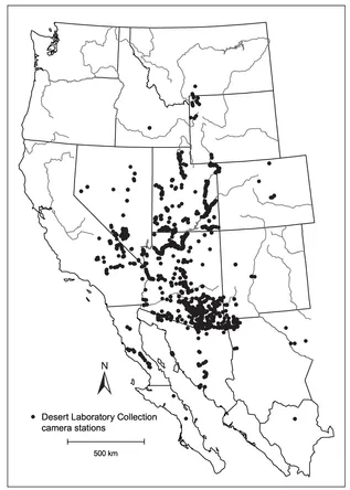
Figure 1.1. The distribution of camera stations in the southwestern United States and northern Mexico included in the Desert Laboratory Repeat Photography Collection. Not shown are camera stations in Kenya (Turner et al. 1998).
In addition to its use in glaciology studies, repeat photography soon was used to document plant populations and landscape change. As early as 1905, ecological texts recommended using matched photographs on research quadrats as an aid to plant population measurements (Clements 1905). One of the earliest studies documented decline in rangeland species between 1903 and 1913 on the Santa Rita Experimental Range south of Tucson (Wooten 1916; see McClaran et al., chapter 12). Forrest Shreve, a pioneering desert ecologist, used repeat photography to document changes in vegetation plots at the Desert Laboratory in Tucson between 1906 and 1928 (Shreve 1929). Before the 1940s, only a few studies used repeat photography to document ecological changes in the southwestern United States (Rogers et al. 1984); most of these were narrowly focused and published in scientific journals or monographs.
In the 1940s, repeat photography became a technique frequently used to document landscape change, particularly changes induced by land use. For example, in 1946, repeat photography was used to demonstrate an increase in Prosopis velutina (velvet mesquite) and other woody species in Arizona grasslands (Parker and Martin 1952), a subject that continues to be of interest in the southwestern
United States (McClaran et al., chapter 12; Turner et al., chapter 17). The tendency of grasslands to change into woody savannas remains a topic of research worldwide (e.g., Lewis, chapter 15).
Repeat photography also gained adherents in the geological discipline, particularly those interested in weathering and bedrock erosion. In southeastern Utah, Bryan and La Rue (1927) compared images of the Navajo Twins near Bluff for signs of weathering over about a two-decade interval. Longwell et al. (1932) illustrated a discussion of waterfall erosion using a matched pair of photographs taken of Niagara Falls, on the Niagara River on the US–Canadian border, before and after a large mass of rock at the edge of the falls fell off on 17 January 1931. Lobeck (1939) included an approximately matched pair (1886 and 1926) showing toppling of blocks from a basalt column in the Palisades of the Hudson River near Fort Lee, New Jersey.
Expeditions in the southwestern United States prior to the development of reliable photography typically included an artist to record the landscape, and expedition members often described the countryside in their journals. Lockett (1939) pioneered the combined analysis of photographic and historical records to describe anecdotally landscape change in northwestern New Mexico and northern Arizona. In 1948, Simpson (1951) used a camera to match sketches of New Mexican landscapes made in the 1870s during a ;paleontological expedition. Relocating and ;rephotographing the scenes depicted in sketches and paintings originally made by expeditionary artists are useful in determining historic routes and camps that are not known precisely (Jonas, chapter 21).
Botanist Homer Shantz of the University of Arizona in Tucson was the first person to use repeat photography to document large-scale geographic changes in plant populations. In 1956–1957, Shantz, assisted by B. L. Turner, repeated images he had taken on 1919–1920 and 1924 excursions in Africa from Cape Town to Cairo (Shantz and Turner 1958). This publication, the first book-length report of landscape change relying entirely on repeat photography, was highly influential in the fledgling field, opening up new possibilities for its application.
Shantz and Turner’s work was constrained by both linear geography (roadways and railroads) and time (the dates of Shantz’s original images). Many of the projects they inspired were similarly defined. In 1968–1969, Stephens and Shoemaker (1987) replicated photographs taken by John K. Hillers and E. O. Beaman during the John Wesley Powell expeditions along the Colorado and Green rivers in the American Southwest. In the early 1970s, Turner and Karpiscak (1980) also worked along the Colorado River but matched photographs from a broad variety of dates and photographers. In 1984, Robert R. Humphrey (1987) matched photographs taken in 1892–1893 along the border between Mexico and the United States. The International Boundary Commission erected 258 monuments along the boundary between El Paso, Texas, and San Diego, California. One or more photographs were taken of each of these monuments. Humphrey was closely restricted geographically and temporally as he moved along this boundary line matching one photograph at each monument. The first major repeat photography project operating in a broad geographic region using historic imagery unrestricted by photographer or date was that conducted by Hastings and Turner (1965), which ultimately gave rise to the Desert Laboratory Repeat Photography Collection.
The Desert Laboratory Repeat Photography Collection
At the beginning of the twentieth century, the Carnegie Institution of Washington endowed a number of biological research stations designed to study typical ecosystems of the United States. Among the regions chosen was the Sonoran Desert, and in 1903, construction began on the Desert Laboratory on a basaltic hill west of downtown Tucson (Bowers 1990). Carnegie assigned the scientists at the Desert Laboratory the task of understanding adaptations of plants and animals to the desert environment and cataloging the species that occupied those regions, but particularly the Sonoran Desert. Carnegie’s role in this research is commemorated in the monospecific genus occupied by the iconic species of the Sonoran Desert, Carnegiea gigantea (saguaro).
Pioneering desert ecologists flocked to the Desert Laboratory, including the highly influential Forrest Shreve (Bowers 1988) and Daniel T. MacDougal, both of whom photographed the desert environment (plate 1.1). The Desert Laboratory remained under the auspices of the Carnegie Institution until 1940, when it was transferred to the US Forest Service as headquarters for the Southwestern Forest and Range Experiment Station (Medina 1996). Forest Service scientists used repeat photography to document changes in rangeland conditions in various parts of southern Arizona (e.g., Parker and Martin 1952), but they did not formally establish a collection of repeat photographs. In the mid-1950s, the facility was transferred to the University of Arizona, where it served as the Laboratory of Geochronology for nearly four decades.
In the late 1950s, Jim McDonald, an atmospheric physicist from the University of Arizona, wanted to analyze vegetation chang...
Table of contents
- About Island Press
- Title Page
- Copyright Page
- Dedication
- Table of Contents
- Foreword
- Preface
- PART I - Techniques
- PART II - Applications in the Geosciences
- PART III - Applications in Population Ecology
- PART IV - Applications in Ecosystem Change
- PART V - Cultural Applications
- About the Editors
- Contributors
- I ndex
- Island Press l Board of Directors
Frequently asked questions
Yes, you can cancel anytime from the Subscription tab in your account settings on the Perlego website. Your subscription will stay active until the end of your current billing period. Learn how to cancel your subscription
No, books cannot be downloaded as external files, such as PDFs, for use outside of Perlego. However, you can download books within the Perlego app for offline reading on mobile or tablet. Learn how to download books offline
Perlego offers two plans: Essential and Complete
- Essential is ideal for learners and professionals who enjoy exploring a wide range of subjects. Access the Essential Library with 800,000+ trusted titles and best-sellers across business, personal growth, and the humanities. Includes unlimited reading time and Standard Read Aloud voice.
- Complete: Perfect for advanced learners and researchers needing full, unrestricted access. Unlock 1.5M+ books across hundreds of subjects, including academic and specialized titles. The Complete Plan also includes advanced features like Premium Read Aloud and Research Assistant.
We are an online textbook subscription service, where you can get access to an entire online library for less than the price of a single book per month. With over 1.5 million books across 990+ topics, we’ve got you covered! Learn about our mission
Look out for the read-aloud symbol on your next book to see if you can listen to it. The read-aloud tool reads text aloud for you, highlighting the text as it is being read. You can pause it, speed it up and slow it down. Learn more about Read Aloud
Yes! You can use the Perlego app on both iOS and Android devices to read anytime, anywhere — even offline. Perfect for commutes or when you’re on the go.
Please note we cannot support devices running on iOS 13 and Android 7 or earlier. Learn more about using the app
Please note we cannot support devices running on iOS 13 and Android 7 or earlier. Learn more about using the app
Yes, you can access Repeat Photography by Robert H. Webb, Diane E. Boyer, Raymond M. Turner, Robert H. Webb,Diane E. Boyer,Raymond M. Turner in PDF and/or ePUB format, as well as other popular books in Tecnologia e ingegneria & Scienze applicate. We have over 1.5 million books available in our catalogue for you to explore.