Landscape Architecture for Sea Level Rise
eBook - ePub

Landscape Architecture for Sea Level Rise

Innovative Global Solutions

  1. 314 pages
  2. English
  3. ePUB (mobile friendly)
  4. Available on iOS & Android
eBook - ePub

Landscape Architecture for Sea Level Rise

Innovative Global Solutions

About this book

This book assesses and illustrates innovative and practical world-wide measures for combating sea level rise from the profession of landscape architecture. The work explores how the appropriate mixture of integrated, multi-scalar flood protection mechanisms can reduce risks associated with flood events including sea level rise.

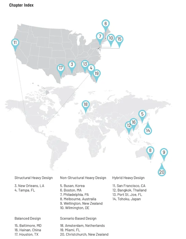
Because sea level rise is a global issue, illustrative case studies performed from the United States, Korea, Australia, New Zealand, Thailand, Japan, China, and the Netherlands identify the structural (engineered), non-structural (nature-based), and hybrid mechanisms (mixed) used to combat sea level rise and increase flood resilience. The alternative flood risk reduction mechanisms are extracted and analyzed from each case study to develop and explain a set of design-based typologies to combat sea level rise which can then be applied to help proctor new and existing communities.

It is important for those located within the current or future floodplain considering sea level rise and those responsible for land use, developmental, and population-related activities within these areas to strategically implement a series of integrated constructed and green infrastructure-based flood risk reduction mechanisms to adequately protect threatened areas. As a result, this book is beneficial to both academics and practitioners related to multiple design professions such as urban designers, urban planners, architects, real estate developers, and landscape architects.

Frequently asked questions

Yes, you can cancel anytime from the Subscription tab in your account settings on the Perlego website. Your subscription will stay active until the end of your current billing period. Learn how to cancel your subscription.
No, books cannot be downloaded as external files, such as PDFs, for use outside of Perlego. However, you can download books within the Perlego app for offline reading on mobile or tablet. Learn more here.
Perlego offers two plans: Essential and Complete
  • Essential is ideal for learners and professionals who enjoy exploring a wide range of subjects. Access the Essential Library with 800,000+ trusted titles and best-sellers across business, personal growth, and the humanities. Includes unlimited reading time and Standard Read Aloud voice.
  • Complete: Perfect for advanced learners and researchers needing full, unrestricted access. Unlock 1.4M+ books across hundreds of subjects, including academic and specialized titles. The Complete Plan also includes advanced features like Premium Read Aloud and Research Assistant.
Both plans are available with monthly, semester, or annual billing cycles.
We are an online textbook subscription service, where you can get access to an entire online library for less than the price of a single book per month. With over 1 million books across 1000+ topics, we’ve got you covered! Learn more here.
Look out for the read-aloud symbol on your next book to see if you can listen to it. The read-aloud tool reads text aloud for you, highlighting the text as it is being read. You can pause it, speed it up and slow it down. Learn more here.
Yes! You can use the Perlego app on both iOS or Android devices to read anytime, anywhere — even offline. Perfect for commutes or when you’re on the go.
Please note we cannot support devices running on iOS 13 and Android 7 or earlier. Learn more about using the app.
Yes, you can access Landscape Architecture for Sea Level Rise by Galen D. Newman, Zixu Qiao, Galen D. Newman,Zixu Qiao in PDF and/or ePUB format, as well as other popular books in Architecture & Urban Planning & Landscaping. We have over one million books available in our catalogue for you to explore.

Information

Part 1 Landscape Architecture and Sea Level Rise

INTRODUCTION

DOI: 10.4324/9781003183419-2
Galen D. Newman and Zixu Qiao

Introduction

The appropriate mixture of integrated, multi-scalar flood protection mechanisms can reduce risks associated with flood events including sea level rise. The magnitude of flood risk is a function of a site's hazard exposure, the characteristics of a particular location, and the vulnerability of an area's people and property. The measures that have been taken to mitigate the potential impact of flooding play a large role in reducing or decreasing the associated risk. It is important for those located in the floodplain or future floodplain considering sea level rise and those responsible for land use, developmental, and population-related activities within these areas to strategically implement a series of integrated constructed and green infrastructure-based flood risk reduction mechanisms to adequately protect threatened areas.
Because sea level rise is a global issue, in this book we assess and illustrate innovative and practical measures for combating sea level rise from the profession of landscape architecture. Illustrative case studies are performed in 18 unique locations worldwide (10 in the US and 8 outside of the US) using an identical framework and identifying the structural (engineered), non-structural (nature-based), and hybrid mechanisms used to combat sea level rise and increase flood resilience. The alternative flood risk reduction mechanisms are extracted and analyzed from each case study to develop and explain a set of design-based typologies to combat sea level rise which can then be applied to help proctor new and existing communities.
The book is arranged in three parts. The first part provides the rationale and background for the book while discussing many of the current landscape architecture approaches to helping solve the myriad of issues related to sea level rise. The introduction, here, will lay the foundation of the contents of the book through providing visualized scientific justification for the existence of sea level rise worldwide. Following this setup, we utilize Chapter 1 to further discuss different climate change projections and their current and future impacts and integrate these findings into design and planning solutions related to green (non-structural) and grey (structural) flood control mechanisms. Finally, at the conclusion of Part 1, in Chapter 2 the book examines different flood mitigation management portfolios utilized and applied in four differing locations globally.
Figure 0.1Case locations by location and chapter number.
Part 2 is a collection of 18 in-depth global case studies (see Figure 0.1) which are all organized along a similar framework and discuss existing and possible structural, non-structural, and hybrid mechanisms for combating flood risks and sea level rise. The part is sub-categorized based on the mechanisms which are favored or used most heavily. Those that did not show a clear reliance on a particular type of mechanism (e.g. structural, non-structural, or hybrid) or were based on scenario evaluation, were classified as either Balanced or Scenario-based Design categories.
The final part of the book extracts the utilized structural, nonstructural, and hybrid mechanisms identified within the case studies, then defines, visualizes, and describes their characteristics. Each mechanism is evaluated and defined along an identical framework. We end this part by presenting a new term for landscape architecture: the urban periculum - a collection of areas that are at risk of flood hazards and sea level rise which constitute a landscape at risk in which the mechanisms showcased in this book should be integrated, mixed, and applied.

Flooding and Sea Level Rise

In the past 21 years, 2.3 billion people were affected by floods and 242,000 deaths were a result of flooding (see Figure 0.2); floods accounted for 40% of the global total for all weather-related disasters during this time period (COOPS, 2016) (see Figure 0.3). In 2017, floods caused approximately $60.7 billion worth of property and crop damage and 116 fatalities across the United States (DESAPD, 2018) (see Figure 0.4).
Figure 0.2Number of weather-related disasters reported per country (1995-2015).
Data source: United Nations, 2015.
Figure 0.3Global annual reported number of floods.
Data sources: US DOC, 2014; NASA, 2017; Statista, 2021.
Figure 0.4Economic damage and fatality rates caused by floods and flash floods in the US.
Data sources: US DOC, 2014; NASA, 2017.
Figure 0.5Global mean sea level since 1993 as observed by satellites.
Data source: NASA, 2021.
Figure 0.6Global mean sea level rise projection by NOAA.
Data source: NOAA, 2017a.
With 4-8 inches of sea level rise expected by 2050, coastal flooding will more than double. Global mean sea level could rise up to 6.6 feet by 2100 (Parris et al., 2012) (see Figures 0.5 and 0.6).
Nuisance flooding is estimated to increase up to 900 percent more frequently within U.S. coastal communities than in the previous 50 years (NOAA, 2017b) (see Figure 0.7).
Figure 0.7Sea level rise scenarios of o to 6 feet along the US Coast.
Data source: NOAA, 2020.
Today, 55% of the world's population lives in urban areas; this is expected to increase to 68% by 2050 (United Nations, 2015). In the US, in 1910, 46% of the population lived in urban areas and by 2010 this number increased to 81% {U.S. Census Bureau, 2015). Coastal areas have the highest population density in the US, with 14 of the nation's 20 largest cities and 19 of the 20 most densely populated counties along the coast (U.S. Census Bureau, 2015) (see Figure 0.8).
Figure 0.8Ranking of United States cities by population in 2017 and the population change from 2010 to 2017.
Data source: U.S. Census Bureau, 2015.
An estimated 6-8 million commercial and residential buildings now reside in the US 100-year floodplains, with an estimated 3 to 7 million additional flood prone buildings within the 500-year floodplains (DiVincenti, 2006) (see Figure 0.9).
Figure 0.9Landcover change within the 100-year and 500-year floodplain in Houston.
Data sources: Google Earth, 2020: FEMA, 2016.

References

  • Center for Operational Oceanographic Products and Services (COOPS). (2016). NOAA Tides and Currents. Retrieved January 28, 2021, from https://tidesandcurrents.noaa.gov/ports.html
  • Department of Economic and Social Affairs Population Division (DESAPD). (2018). World Urbanization Prospects: The 2018 Revision. Retrieved November 15, 2020, from https://population.un.org on
  • DiVincenti, C., Wetmore, F., & Bernstein, G. (2006). The evaluation of the National Flood Insurance Program final report. Washington D.C.: American Institutes for Research. Retrieved from https://biotech.law.lsu.edu/disasters/insurance/nfip_eval_final_report.pdf
  • Federal Emergency Management Agency (FEMA). (2020). FEMA Flood Map Service Center: Search by Address. Retrieved October 26, 2020, from https://msc.fema.gov/portal/search#searchresultsanchor on
  • Google Earth. (2020). V 6.2.2.6613, December 30, 2020, Houston, TX, USA. DigitalGlobe. Retrieved October 26, 2020, from www.earth.google.com
  • National Aeronautic and Space Administration (NASA) (2017). Sea Level Change, Observations from Space. Retrieved July 10, 2020, from https://sealevel.nasa.gov/
  • National Aeronautics and Space Administration (NASA) Goddard Space Flight Center. (2020). Global Climate Change: Vital Signs of the Planet. Global mean sea level since 1993 as observed by satellites [Chart]. Retrieved December 13, 2020, from https://climate.nasa.gov/vital-signs/sea-level/
  • National Oceanic and Atmospheric Administration (NOAA). (2017a). National Ocean Service Sea Level Rise Viewer. Retrieved January 15, 2021, from https://coast.noaa.gov/slr/#/layer/slr/o/-11581024.663779823/5095888.569004184/4/satellite/none/0.8/2050/interHigh/midAccretion
  • National Oceanic and Atmospheric Administration (NOAA). (2017b). In Port: NOAA Office for Coastal Management sea level rise data: 1-10 ft sea level rise inundation [Dataset]. Retrieved December 5, 2020 from www.fisheries.noaa.gov/inport/item/48106
  • Parris, A. S., Bromirski, P., Burkett, V., Cayan, D. R., Culver, M. E., Hall, J., . . . & Weiss, J. (2012). Global sea level rise scenarios for the United States. National Climate Assessment. Retrieved from https://repository.library.noaa.gov/view/noaa/11124
  • Statista. (2021). "In your view, what are the most important environmental issues that Italy faces today?" New York: Statista. Retrieved August 13, 2020, from www.statista.com/statistics/865499/top-three-most-concerningenvironmental-issues-in-italy/
  • United Nations. (2015). The human cost of weather-related disasters. Centre for Research on the Epidemiology of Disasters Office for Disaster Risk Reduction. Retrieved February 25, 2021, from www.undrr.org/publication/human-cost-weather-related-disasters-1995-2015
  • U.S. Census Bureau. (2015). Emergency Management: Floods. Retrieved January 9, 2021, from www.census.gov/topics/preparedness/events/floods.html
  • U.S. Department of Commerce (US DOC). (2014). Global sea level rise scenarios for the United States National Climate Assessment: Technical report. Washington D.C.: CreateSpace Independent Publishing Platform.
  • Vitousek, S., Barnard, P. L., Fletcher, C. H., Frazer, N., Erikson, L., & Storlazzi, C. D. (2017). Doubling of coastal flooding frequency within decades due to sealevel rise. Scientific Reports, 7(1), 1399.

1 SEA LEVEL RISE AS A DESIGN AND PLANNING ISSUE

DOI: 10.4324/9781003183419-3
Galen D. Newman, Zixu Qiao, and Rui Zhu

Introduction

Hazard Exposure and Climate Change

Climate change is a global issue which has had observable negative impacts on standard development practices and has resulted in increased disaster risk for both people and communities. One of the impacts of climate change is increased flood frequency and magnitude. Floods are the most common natural disaster and the leading cause of natural disaster fatalities worldwide (Doocy et al., 2013). They can cause significant catastrophes and result in the loss of life, property, and natural resources and functions. A recent report entitled The Human Cost of Weather-Related Disasters by the United Nations (UN) (2015) shows that, in the past 21 years, floods account for nearly 40% of the global total for all weather-related disasters, have affected 2.3 billion people, and accounted for 242,000 deaths. Further, 89% of flood-related deaths occurred in lower-income countries, despite only experiencing 26% of all flood-related storms.
In 2017 alone, floods caused approximately $60.7 billion worth of property and crop damage, and 116 fatalities across the United States (Pen6ning-Rowsell et al., 2018). For example, Hurricane Harvey wreaked havoc on the Texas coast in 2017, causing 89 deaths and $125 billion in damage (Stone et al., 2019). More than 30 inches of rainfall fell on 6.9 million people during Harvey (see Figure 1.1), while 1.25 million people experienced over 45 inches of rainfall (Sebastian et al., 2019). This historic US rainfall event caused unprecedented amounts of floodwater which displaced over 30,000 people and damaged or destroyed over 200,000 homes and businesses (NOAA, 2018).
All coastal regions are projected to experience significant increases in frequency of both minor and major flooding over a range of future sea level rise levels. Global climate change also increases the frequency of coastal flooding. A report from the U.S. Geological Survey (Ober, 2017) suggests an expect...

Table of contents

  1. Cover
  2. Half Title
  3. Title
  4. Copyright
  5. Contents
  6. Foreword
  7. List of Contributors
  8. PART 1 Landscape Architecture and Sea Level Rise
  9. PART 2 Global Design for Sea Level Rise Structural Heavy Design
  10. Non-structural Heavy Design
  11. Hybrid Heavy Design
  12. Balanced Design
  13. Scenario-based Design
  14. PART 3 Innovative Solutions for Sea Level Rise
  15. Index