Even leaving aside the vast death and suffering that it wrought on indigenous populations, German ambitions to transform Southwest Africa in the early part of the twentieth century were futile for most. For years colonists wrestled ocean waters, desert landscapes, and widespread aridity as they tried to reach inland in their effort of turning outwardly barren lands into a profitable settler colony. In his innovative environmental history, Martin Kalb outlines the development of the colony up to World War I, deconstructing the common settler narrative, all to reveal the importance of natural forces and the Kaisereich's everyday violence.
Trusted by 375,005 students
Access to over 1.5 million titles for a fair monthly price.
The journey across arid stretches of land had been worth it. Back in 1894, Ernst Hermann, who had been working for the Deutsche Kolonialgesellschaft (German Colonial Society), sent Englishman Walter Matthews to find out where all the seals had gone. They had become hard to find around Lüderitzbucht, a harbor in the south of the colony the Germans had claimed ten years earlier. Matthews, “one of the weirdest characters,” according to one newspaper,1 traveled by ship to Walvis Bay. After landing, he must have heard about a seal colony at Cape Cross, located about 160 kilometers farther to the north along the coast. Since using a boat in coastal waters was too dangerous, Matthews, his two assistants, and several pack mules trekked overland, first to Swakopmund, then onward into a waterless and barren land. Any such journey required careful preparation, with multiple trips just to place water containers along the way to be used later on.2 When they laid eyes on thousands of seals hanging out on a large rocky cliff, and even more so once they stumbled upon deposits of guano (Hispanicized Quechua word wanu for fertilizer/dung), all such burdens seemed worth it. Matthews did not hesitate: he reached out to C. J. Elers, a wealthy uncle and the managing director of Barret’s Breweries and Bottling Co. Ltd. in London, formed the Damaraland Guano Company, and obtained the required concessions from the German colonial government. Workers from Britain and the Cape, food, timber, even a locomotive, everything had to be brought in by ship.3 Landings were dangerous. After all, this was the infamous Skeleton Coast, part of Namibia’s almost thousand-mile coastline littered with shipwrecks turned maritime artifacts.4 In September 1896, the Norwegian bark Erycina sprang a leak and sank while unloading coal; that same year another ship stranded in the bay.5 In other instances, crew members simply refused to cross the hammering surf.6 Problems accessing drinking water also defined life at this commodity outpost, especially when supplies from overseas got delayed. At that point an ox wagon had to trek back to the ephemeral Omaruru River hoping to find water. Life was thus a struggle, defined by hard labor in virtual isolation, rampant diseases, limited medical care, boredom, and miserable damp weather.
Environmental infrastructure within the borderland sitting in-between the waters of the Atlantic Ocean and arid landscapes of an ever-encroaching Namib Desert were defined by human ingenuity, labor, non-human actors, and natural forces. Here, African societies like the Topnaar (also known as ╪Aonin), one subgroup of the Nama and thus part of the Khoisan, lived in outwardly inhospitable landscapes raising livestock and trading with groups in the interior; here European explorers sailed on the margins fearing wreckage and barren spaces. Both the dangerous ocean waters and arid desert landscapes initially protected Africans from European colonialism; that same frontier also laid the groundwork for an intricate ecosystem sustaining rich marine wildlife that attracted whales, seals, and all kinds of birds. By the eighteenth-century, the commodification of nature attracted Europeans and Americans to the region to plunder whale oil, seal skins, and guano. According to archeologists Jill and John Kinahan, “Isolated contacts with Europeans first occurred in the late seventeenth century, becoming more frequent a century later, and then permanent.”7 Although the Topnaar were originally able to take advantage of new trade opportunities, the goods they acquired, combined with rising cattle raids in the interior, eventually weakened them.8 Protagonists such as whalers, sealers, and guano miners, on the other hand, introduced new economic and governmental structures to the region. Non-human actors such as whales had to adapt and migrate. A study of this liminal space offers a sense of location, commodity trade, and early interactions. Moreover, it provides the basis for understanding how early structures ultimately framed and manipulated subsequent German colonization. Finally, this section further sustains historian George Steinmetz’s assertion that “There was not, in fact, a sharply delineated transition from precolonialism to colonialism in Southwest Africa.”9
Chapter 1 is organized along four sections, beginning with an introduction of the environmental borderland, or what archaeologist John Kinahan has titled the “last frontier of European imperialism in Africa.”10 A more in-depth discussion of the Benguela Current and Namib Desert are key when trying to make sense of natural forces that make this a non-equilibrium environment.11 Historians are correct when noting that “the proverbial bleakness of the coastline … largely deterred Europeans from attempting to settle or trade until the second half of the eighteenth century, although the coast had been known to them since the early 1480s.”12 However, and as emphasized in the following, the commodification of nature, a form of human agency, to follow Kreike,13 pulled cunning businessmen into the region by the seventeenth century. Three major booms are front and center: whaling, sealing, guano mining. Environmental infrastructure, shaped by geographical, biological, and ecological factors, as well as human ingenuity and labor, ultimately initiated early encounters and defined the incorporation of the coastline into the global marketplace.
On the Margins
The coastline of Namibia is littered with shipwrecks that tell stories of treacherous ocean waters and difficult navigation. North of modern-day Swakopmund, tourists can search for the now fully covered wreck of the Gertrud Woermann II. It stranded in 1904. The Zeila, a fishing trawler now bouncing back and forth between hazardous waves, as well as the beached wrecks of Benguela Eagle, Montrose, Suiderkruis, Sir Charles Eliot, and Dunedin Star, all long the fuel of adventures stories, are other maritime artifacts discarded along the so-called Skeleton Coast. According to historian Jennifer Jones, “They serve as icons for a unique historical and environmental context against a backdrop of desolate, desert landscape.”14 Take the wreck of a Portuguese vessel first discovered at Oranjemund in 2008. The diamond company Namdeb, a joint venture between the Namibian government and DeBeers, found its remains during excavation work.15 Precious diamonds were once deposited upstream of the Orange River. Over time those were flushed down and into the ocean, spreading along much of the southern coast of Namibia and the Northern Cape of South Africa. Namdeb now mines in a Sperrgebiet (forbidden zone) reaching from the South African border to about seventy kilometers north of Lüderitzbucht. In any case, after some of their workers spotted the seafaring relic, archaeologists identified it as the legendary Bom Jesus. Owned by Portuguese King João III, it sank on its way from Lisbon to western India in 1533. According to one expert, a combination of factors including excess cargo and bad weather likely resulted in the wreckage.16 Sailing along the coast of Southwest Africa in early days, and on some level even today, meant traveling on the margins.
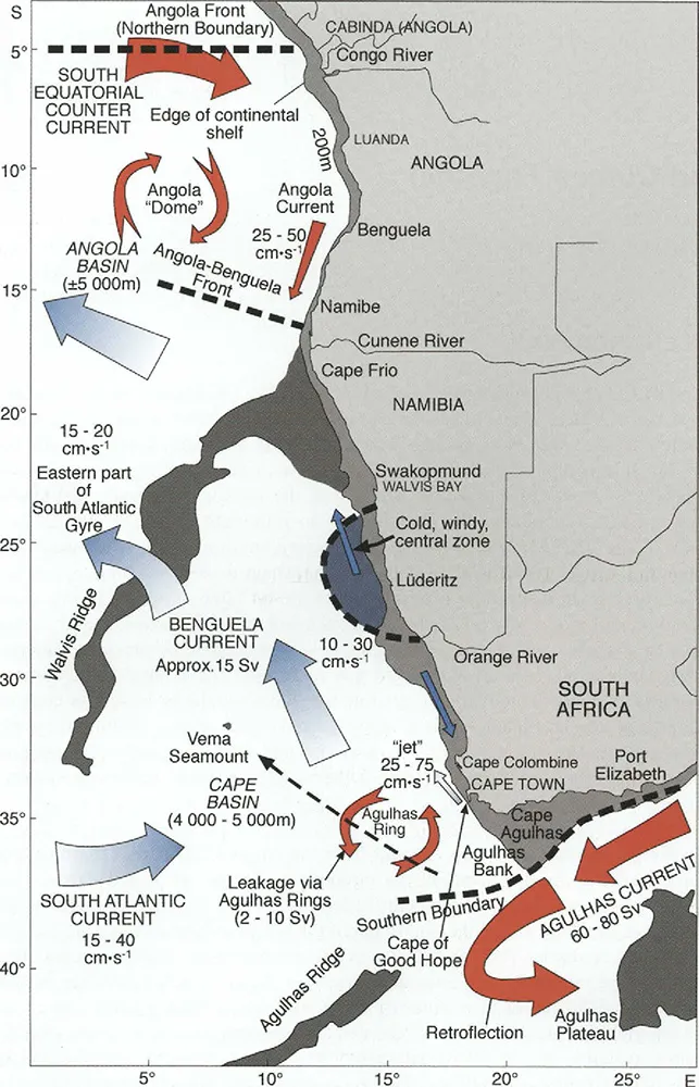
Namibia’s coastline is a dangerous frontier space characterized by an array of natural forces. The country is located within what scholars call a swell wave environment. Those are defined by large waves traveling vast distances across the Atlantic Ocean from the southwest. Gale winds also push toward a rugged coastline. Then, there is the infamous Benguela Current, one of four main eastern boundary upwelling systems in the world. As a strong surface current, it arrives in the region with cold water from the southern Atlantic, wandering up the coast to around the mouth of the Kunene River. Anticyclonic winds drive such movements northward while counter currents below flow southward (Figure 1.1).17 An unstable process known as upwelling or lifting emerges as “cool waters from the deep offshore are brought to the surface of the coast,” to follow an explanation from the aquarium in Swakopmund.18 Coastal upwelling systems like the Benguela Current are what scholars call “the ‘powerhouse’ of phytoplankton production.”19 A rich marine ecosystem is the result of that, attracting fish, whales, seals, and all kinds of birds. At the same time, the system’s variabilities, overall currents and upwelling, and its pull away from the coastline in a circular motion turns dreams of calm and predictable coastal waters into the plotline for nightmares. Ever-shifting beaches made the coast no more than a “fantasy line,” to follow one German missionary later on.20 Sailors stayed away, if at all possible, fearing a more or less uncharted seashore that also lacked natural harbors. As a result, and as one scholar concluded, “The whole of the Namibian coastline was virtually terra incognita during the eighteenth century and had only been visited by passing ships on occasion.”21
Figure 1.1. Benguela Current (2006), courtesy of Vere Shannon/Elsevier.
The Namib Desert equally defines this borderland. Linked to the desiccating effect of water welling from the Benguela Current,22 that ancient arid backdrop dominates the country’s geography behind hazardous ocean waves. Considered to be among the world’s oldest deserts, the Namib (!Namib), a Nama (Khoikhoi language) term that means “shield” or “enclosure,”23 extends for more than 2,000 kilometers and eighteen degrees of latitude. As outlined by biologist Mary Seely, “Most of the year the strong southwester blows. This results in maintenance of a cool inversion layer, that is, a layer of cooler air lying below a layer of warmer air. An inversion layer reduces the turbulence necessary for cloud development and thus prevents rain.”24 Estimates note an average of less than fifteen mi...
Table of contents
Cover
Title Page
Copyright Page
Dedication
Contents
List of Figures
Acknowledgments
Introduction
Chapter 1. Currents, Chances, Commodities
Chapter 2. Accessing Arid Lands
Chapter 3. Harbors, Animals, Trains
Chapter 4. Solving Aridity
Chapter 5. Access and Destruction
Chapter 6. Expanding War and Death
Chapter 7. Creating a Model Colony
Conclusion
Selected Bibliography
Indexes
Frequently asked questions
Yes, you can cancel anytime from the Subscription tab in your account settings on the Perlego website. Your subscription will stay active until the end of your current billing period. Learn how to cancel your subscription
No, books cannot be downloaded as external files, such as PDFs, for use outside of Perlego. However, you can download books within the Perlego app for offline reading on mobile or tablet. Learn how to download books offline
Perlego offers two plans: Essential and Complete
Essential is ideal for learners and professionals who enjoy exploring a wide range of subjects. Access the Essential Library with 800,000+ trusted titles and best-sellers across business, personal growth, and the humanities. Includes unlimited reading time and Standard Read Aloud voice.
Complete: Perfect for advanced learners and researchers needing full, unrestricted access. Unlock 1.5M+ books across hundreds of subjects, including academic and specialized titles. The Complete Plan also includes advanced features like Premium Read Aloud and Research Assistant.
Both plans are available with monthly, semester, or annual billing cycles.
We are an online textbook subscription service, where you can get access to an entire online library for less than the price of a single book per month. With over 1.5 million books across 990+ topics, we’ve got you covered! Learn about our mission
Look out for the read-aloud symbol on your next book to see if you can listen to it. The read-aloud tool reads text aloud for you, highlighting the text as it is being read. You can pause it, speed it up and slow it down. Learn more about Read Aloud
Yes! You can use the Perlego app on both iOS and Android devices to read anytime, anywhere — even offline. Perfect for commutes or when you’re on the go. Please note we cannot support devices running on iOS 13 and Android 7 or earlier. Learn more about using the app
Yes, you can access Environing Empire by Martin Kalb in PDF and/or ePUB format, as well as other popular books in History & African History. We have over 1.5 million books available in our catalogue for you to explore.