- English
- ePUB (mobile friendly)
- Available on iOS & Android
eBook - ePub
About this book
It is a resource book that profiles the geography, demography, economy, political environment and business climates for each of China's 31 provinces. It will become a useful source book to researchers, businesses, government agencies, and news media interested in either the rapidly changing provincial economies or the Chinese economy as a whole.
Trusted by 375,005 students
Access to over 1.5 million titles for a fair monthly price.
Study more efficiently using our study tools.
Information
Topic
EconomíaSubtopic
Negocios internacionalesPart I
Provinces A–Z
Anhui
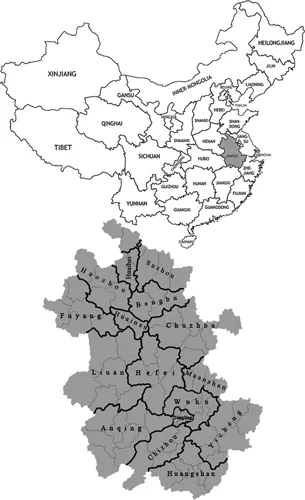
Source: The author, based on a file from the Wikimedia Commons.
Table A The administrative divisions of Anhui
| Name | Administrative seat | Population |
Anqing PM | Yingjiang District | 5,311,000 |
Bengbu PM | Longzihu District | 3,164,000 |
Bozhou PM | Qiaocheng District | 4,851,000 |
Chizhou PM | Guichi District | 1,403,000 |
Chuzhou PM | Langya District | 3,938,000 |
Fuyang PM | Yingzhou District | 7,600,000 |
Hefei PM | Luyang District | 7,457,000 |
Huaibei PM | Lieshan District | 2,114,000 |
Huainan PM | Tianjia’an District | 2,334,000 |
Huangshan PM | Tunxi District | 1,359,000 |
Lu’an PM | Jin’an District | 5,612,000 |
Ma’anshan PM | Yushan District | 2,304,000 |
Suzhou PM | Yongqiao District | 5,353,000 |
Tongling PM | Tongguanshan District | 724,000 |
Wuhu PM | Jinghu District | 3,443,000 |
| Xuancheng PM | Xuanzhou District | 2,533,000 |
Notes: PM = prefectural level municipality. All data are as of 2010.
Quick facts
Official name: Anhui Province
Abbreviated name: Wan
Land area: 139,400 km2
Population (as of 2010): 59,567,000
Population density: 440/km2
GRP per capita of 2010: ¥20,888
HDI of 2008: 0.750
Capital: Hefei
Address of government office: 221 Changjiang Road, Hefei City
Tel: 0551–260–1113/260–1114
Postcode: 230001
Website: www.ah.gov.cn
Anhui is a province of the PRC. Its name derives from the names of two cities – Anqing and Huizhou (now Huangshan City) – both of which are located in south Anhui. The abbreviation for the province is “Wan”, because in ancient times there was a state called Wan in areas around the mountain called Wan in the province.
Situated in the southeast of China, and across the basins of the Yangtze and the Huai rivers, Anhui Province shares borders with Jiangsu Province to the east, Zhejiang Province to the southeast, Jiangxi Province to the south, Hubei Province to the southwest, Henan Province to the northwest and Shandong Province to the north. It extends about 570 km from north to south, and 450 km from west to east, with an area accounting for 1.45% of the country.
There are 17 prefecture-level administrative divisions in Anhui, which are subdivided into 105 county-level divisions (44 districts, 5 county-level cities and 56 counties). Those are in turn divided into 1,845 township-level divisions (972 towns, 634 townships, 9 ethnic townships and 230 sub-districts).
Topographically, Anhui Province is quite diverse. The north is part of the North China Plain, while the north-central areas are part of the Huai River watershed. Both of these regions are very flat and densely populated. The land becomes more uneven further south, with the Dabie Mountains occupying much of southwestern Anhui and a series of hills and ranges cutting through the southeast. The Yangtze River finds its way through south Anhui between these two mountainous regions. Major rivers include the Huai in the north and the Yangtze in the south. Lake Chaohu, with an area of about 800 km2, is the largest lake and is located in the center of the province. The southeastern part of Anhui near the Yangtze River has many lakes as well.
With the Yangtze and Huai rivers running through the province from the west to the east, Anhui is divided into three geographical regions, including Huaibei (north of the Huai), Jianghuai (between the Yangtze and the Huai) and Jiangnan (south of the Yangtze). The north of the Huai, part of the North China Plain, is a vast expanse of flatland. The middle area between the Yangtze and the Huai is a chain of undulating hills. The lands by the two sides of the Yangtze and around Lake Chaohu are low and flat, belonging to the well-known Middle-Lower Yangtze River Plain. The south mainly comprises hills.
Generally, the province can be divided into five topographical zones: the plain north of the Huai River, the hilly land between the Huai and Yangtze rivers, the Dabieshan mountain area of West Anhui, the plains along the Yangtze River and the hilly area in southern Anhui. Located in the transition region of the warm-temperate zone and sub-tropical zone, the climate is warm and humid with distinct seasons. The province’s annual rainfall and weather in general varies greatly, with frequent spring droughts and summer floods.
Anhui differs in climate from north to south. The north is more temperate and has more clear-cut seasons. The average annual temperature of the province is 14–17 ºC. January temperatures average −1 to 2 ºC north of the Huai, and 0–3 ºC south of the Huai. In July, temperatures average 27 ºC or above. The average frost-free period lasts 200–250 days. Plum rains (a term used in some Chinese provinces to denote the rainy season) occur in June and July and may cause flooding. The annual average rainfalls are 800–1,800 mm. Plum rains occur in June and July and may cause flooding.
Anhui has a variety of natural resources. It has rich mineral reserves and the deposits of iron, copper, pyrite, limestone and alunite are among the top five in the nation. In addition, these resources are concentrated in distribution. Among the 138 discovered minerals, 104 have had their reserves proved. Major production sites of minerals in the province include iron in Ma’anshan, coal in Huainan and copper in Tongling, and there are industries related to these natural resources.
Covering an area of 4.33 million ha/40,907 km2 of fertile farmland and benefiting from the mild climate, Anhui Province is rich in agricultural resources. Its major crops include rice, wheat and sweet potato. Many of its agricultural products are also famous. These include grapes, pears, pomegranates, tea and crabs. Agriculture varies according to the climate zones that the province crosses. Wheat and sweet potatoes are grown on the northern side of the Huai River, while rice and wheat are on the southern side. The total water reserve of Anhui is about 68 billion m3. The Bishihang Irrigation Project and the Simashan Diversion and Irrigation Project are two key irrigation projects of the province. Forested areas amounted to 3.6 million ha as of the end of 2005.
Anhui is rich in plants and animals. It has 1,300 woody plants and 2,100 herbaceous plants. Among its more than 500 species of animals, 54 are listed as rare and under state protection, including the Yangtze alligator and the white-fin dolphin.
As of 2005, the province had established 31 nature reserves, including 5 at the national level, 25 at the provincial level and 1 at the county level. Its principal tourism sites include ancient villages in southern Anhui (e.g. Xidi and Hongcun [World Heritage Site]); Mount Huangshan (World Heritage Site); Mount Jiuhua; Mount Qiyun; Mount Tianzhu; the old town of Tunxi; Mount Langya; Zuiweng Pavilion, named after the poet Ouyang Xiu (AD 1007–1072); Lake Chao; Taiji Cave (the longest karst cave in East China); and the Zhenfeng Pagoda (a Ming Dynasty pagoda in Anqing City).
In 2010, Anhui’s nominal GRP was ¥1.23 trillion (about US$181.1 billion) and per capita was ¥20,888 (about US$2,400). It is considered to be a mid-size province in terms of economic output. Compared with its more successful neighbors to the east, Zhejiang and Jiangsu, Anhui has lagged markedly behind in economic development, with a GRP per capita around one-third of those two provinces. There is great regional disparity as well. Regions such as Hefei, Wuhu and Ma’anshan have benefited from their closeness to the Yangtze River and so are significantly wealthier than the rest of the province due to their industrial and manufacturing industries.
Table B Demographic and socioeconomic profile: Anhui
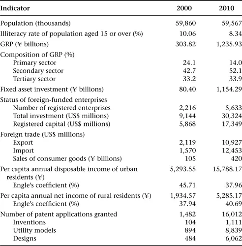
Note: All monetary values are measured at current prices.
Source: Anhui Statistical Yearbook, 2001 and 2011.
Anhui’s GRP is largely driven by fixed asset investment (FAI). This, coupled with the province’s pool of c...
Table of contents
- Cover
- Title Page
- Copyright
- Contents
- Acknowledgments
- Notes on the Text
- List of Abbreviations
- Units of Measurement
- Glossary
- Maps and Tables
- Introduction
- Part I: Provinces A–Z
- Part II: Ranking the Provinces
- Appendix
- Index
Frequently asked questions
Yes, you can cancel anytime from the Subscription tab in your account settings on the Perlego website. Your subscription will stay active until the end of your current billing period. Learn how to cancel your subscription
No, books cannot be downloaded as external files, such as PDFs, for use outside of Perlego. However, you can download books within the Perlego app for offline reading on mobile or tablet. Learn how to download books offline
Perlego offers two plans: Essential and Complete
- Essential is ideal for learners and professionals who enjoy exploring a wide range of subjects. Access the Essential Library with 800,000+ trusted titles and best-sellers across business, personal growth, and the humanities. Includes unlimited reading time and Standard Read Aloud voice.
- Complete: Perfect for advanced learners and researchers needing full, unrestricted access. Unlock 1.5M+ books across hundreds of subjects, including academic and specialized titles. The Complete Plan also includes advanced features like Premium Read Aloud and Research Assistant.
We are an online textbook subscription service, where you can get access to an entire online library for less than the price of a single book per month. With over 1.5 million books across 990+ topics, we’ve got you covered! Learn about our mission
Look out for the read-aloud symbol on your next book to see if you can listen to it. The read-aloud tool reads text aloud for you, highlighting the text as it is being read. You can pause it, speed it up and slow it down. Learn more about Read Aloud
Yes! You can use the Perlego app on both iOS and Android devices to read anytime, anywhere — even offline. Perfect for commutes or when you’re on the go.
Please note we cannot support devices running on iOS 13 and Android 7 or earlier. Learn more about using the app
Please note we cannot support devices running on iOS 13 and Android 7 or earlier. Learn more about using the app
Yes, you can access Regional China by Rongxing Guo in PDF and/or ePUB format, as well as other popular books in Economía & Negocios internacionales. We have over 1.5 million books available in our catalogue for you to explore.