Drawing on extensive and carefully designed ethnographic fieldwork in the Ferghana Valley region, where the state borders of Kyrgyzstan, Tajikizstan and Uzbekistan intersect, Madeleine Reeves develops new ways of conceiving the state as a complex of relationships, and of state borders as socially constructed and in a constant state of flux. She explores the processes and relationships through which state borders are made, remade, interpreted and contested by a range of actors including politicians, state officials, border guards, farmers and people whose lives involve the crossing of the borders. In territory where international borders are not always clearly demarcated or consistently enforced, Reeves traces the ways in which states' attempts to establish their rule create new sources of conflict or insecurity for people pursuing their livelihoods in the area on the basis of older and less formal understandings of norms of access. As a result the book makes a major new and original contribution to scholarly work on Central Asia and more generally on the anthropology of border regions and the state as a social process. Moreover, the work as a whole is presented in a lively and accessible style. The individual lives whose tribulations and small triumphs Reeves so vividly documents, and the relationships she establishes with her subjects, are as revealing as they are engaging. Border Work is a well-deserved winner of this year's Alexander Nove Prize.
- 312 pages
- English
- ePUB (mobile friendly)
- Available on iOS & Android
eBook - ePub
About this book
Trusted by 375,005 students
Access to over 1.5 million titles for a fair monthly price.
Study more efficiently using our study tools.
Information
Subtopic
Central Asian HistoryIndex
Social Sciences1. LOCATIONS
Place and Displacement in Southern Ferghana
It is the last day of August 2004 in Batken town in Kyrgyzstan’s far southwest: a dry, windless day typical of late summer when life congregates on the shady side of the street. I join the crowd that has gathered in the rectangular shadow of the town’s post office to await the daily bus bound for Ak-Sai, a border village thirty kilometers to our west lying in the valley of the Isfara River. There is always a throng of people here long before the bus’s scheduled departure at 5 pm. The bus often leaves early, and those who arrive first have the best chance of a seat for the two-and-a-half-hour ride. On this occasion the crowd is larger than usual. August 31, 2004 marks the thirteenth anniversary of Kyrgyzstan’s independence, and the town’s usually empty stadium has today been bustling with activity. Officials in suits and ties, school girls in Kyrgyz national costume and conscript soldiers from the nearby barracks have joined the dozens of families who have come to take part in this annual celebration.
Independence Day is a state holiday in Kyrgyzstan, and the back wall of the stadium bears a large banner reminding onlookers that 2004 is, by presidential decree, the year of “conscientious leadership and social mobilization.”1 In the center of the stadium’s soccer field, parched from the summer sun, a yurt-shaped podium has been installed with a sound system to broadcast speeches from the regional governor and members of his administration. Much the busiest part of the stadium, however, is far from these proceedings, where a series of tables has been set up in the shade, selling plov—the meat and rice dish that is a staple at celebratory occasions in Batken, as well as ice cream and succulent kebobs.
Most of the people visiting the festivities, adults and children alike, seem largely oblivious to the content of the speeches ringing out from the center of the stadium. “Independence Day” is the opportunity for a celebration: a day off from work; the chance to dress up children in their best clothes; the excuse to share news with kin from other villages; and, for many rural families, the opportunity for some last minute shopping in the district’s central market before the start of the new school year. Down the road from the stadium, as the cluster of passengers awaiting the Ak-Sai bus swells with families returning from the festivities, conversation moves from the celebrations here in the district center to the growing cost of school uniforms and the state of this year’s apricot crop.
By 2004, the yellow Soviet-era Pazik bus, which I took on multiple occasions during the course of my research in and around Batken, had been making this journey once daily in each direction for the previous thirty years. Names and years scratched in a child’s handwriting into the peeling paint date the bus to the early 1970s, the period when several of the villages that we will travel through on our way to Ak-Sai had been established and many of today’s elders were forcibly relocated from smaller pastoral settlements in the mountains to the town’s south. Bales of sweet-smelling fleece wool stuffed under the back row seats remind of the continued seasonal migration that links these newer, gridded villages in the valley basin with the summer pastures (jailoo) in the mountains above. The bus’s demographic mix as we clamber aboard speaks of newer kinds of movement on which the region has come to depend for its livelihood. Most of the adult passengers boarding in Batken are women. Many—perhaps even a majority of the young mothers on board—have husbands and sons working on construction sites in urban Russia for months or years at a stretch. By 2004 Kyrgyzstan had become one of the most remittance-dependent countries in the world, and of its seven provinces, Batken has some of the country’s highest rates of out-migration for work.2 Little wonder, then, that elders here would often compare the seasonal departure of young men to construction sites in urban Russia to the wartime departure “to the front” of their parents’ generation.
As new passengers join and standing room is filled to the limit, infants are passed to seated strangers to be cared for during the journey. Older men and women who board later in the journey will be provided with sitting space, entailing a careful rearrangement of people and goods at each new stop. Kyrgyz and Tajik elders, known as aksakals in Kyrgyz, mūisafed in Tajik (in both languages meaning “white beards”), for whom seats have been found at the front of the bus, greet each other with a “peace be with you” (assalomu aleikum), followed by a rapid exchange of questions in a dialect of Kyrgyz heavily inflected with Tajik and Uzbek vocabulary. How is your health? Are you sitting peacefully? How are your children? Are they peaceful? Is everything in order (duruspu)? Followed by an “ah, good, ah good” (tüzük tüzük) before settling back into silence.3
The Batken Zone
Our journey from Batken, Kyrgyzstan’s newest oblast capital with a population of roughly 13,000 people, takes us through one-half of the Batken zone (Batken zonasy or Batken aimagy), the irrigation-dependent plateau that extends for sixty kilometers from the Sokh River in the east to the Isfara River in the west. Located today at the cusp of three new states, this region of southern Ferghana has historically been a site of considerable social, ecological, and linguistic contact. Place names and demography reflect the historical interdependence between settled and pastoral modes of life and the dynamic interaction between speakers of Turkic and Persianate languages. Many places along our route are commonly called by two (and sometimes three) names—including Tajik, Kyrgyz, and more recent Russian variants.4 The very name Batken, which means “confluence of winds,” can be traced etymologically to both Kyrgyz and Tajik. “You can expound on the meaning of the word in any language you like,” one local poet writes at the start of her study of the region, before telling her reader, matter-of-factly, that she would rather describe the region with a song (Joosh kyzy 1997, 4).
Concrete waterways crisscross this landscape, running alongside roads and fanning through a complex network of mud channels that serve as irrigation ditches (aryks) under walls and into gardens. As the Ak-Sai bus traces a route west out of town the gray, parched hills where the water doesn’t reach remind just how vital that irrigation is to sustaining homes and livelihoods. To our north lies the large fertile basin of the Ferghana Valley: densely populated and intensely cultivated with the cotton that sustains Uzbekistan’s exports. To the south lie the high slopes of the Alay Mountains, the farthest of them still snow-capped on this late August day. In between lies the hilly hinterland of sharp grays and reds—the boz adyr (gray hills)—of the Batken zone.
This is a region decisively transformed by the ambitious arc of soviet modernization. The rock and asphalt road through this landscape was established in the heyday of “developed socialism” in the 1960s and 1970s when the region was undergoing a period of profound social and economic transformation.5 The development of artificial irrigation on an industrial scale in the post-war period had opened barren landscapes to collectivized agriculture, transforming the de facto boundaries of collective farms and administrative districts. In the same period, high mountain villages and summer encampments, some of them well over 2,000 meters above sea level and only a few households in size, were consolidated and their populations moved to more “economically productive” areas in the lower-altitude adyr zone.6 Ak-Sai, at the far end of the Batken bus route, built in the early 1970s to resettle Kyrgyz pastoralists from higher mountain settlements at the source of the Isfara river was one such village. Batken was another, with gridded structure, municipal buildings, and landmarks reflecting its consolidation as a Soviet Kyrgyz “village of urban type” (poselok gorodskogo tipa).
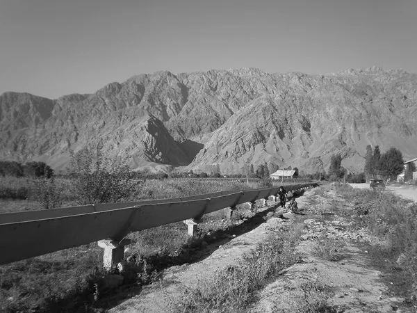
Soviet-era irrigation infrastructure in the Isfara Valley. Locally the road and canal are taken to mark the border: to the left is Tajikistan, to the right is Kyrgyzstan.
In this late-Soviet period of socio-spatial transformation, the Batken–Ak-Sai bus would have tacked back and forth between the Kyrgyz and Tajik Soviet Socialist Republics, connecting several collective farms with each other and with their district centers, and integrating two distinct linguistic communities into a shared socialist space. By the mid-2000s, several decades of sedentarizing, collectivizing, settling and resettling of populations, irrigating and swapping of land had transformed this barren “stony place” (tashtyk jer) into a series of densely populated zones of tightly grouped courtyards, cultivated fields and apricot orchards; splashes of green and white in an otherwise arid landscape of gray-red rock and scree. It had also created a border between now-independent states that is complex, contested and, in many areas, still awaiting conclusive delimitation: indeed, two decades after independence, nearly half of the 970-kilometer border between Tajikistan and Kyrgyzstan remains to be conclusively delimited.7
To trace the route of the Batken–Ak-Sai bus on a map of the region would reveal that we crossed back and forth over this new international border no fewer than six times in the course of the fifty-kilometer journey, with some of these stretches of alternating jurisdiction just a few dozen meters in length. We passed from Kyrgyzstan into Tajikistan at Surh, then back into Kyrgyzstan at Samarkandek, then into Tajikistan again for 200 meters as we crossed over the Isfara River, then Kyrgyzstan again for the village of Kök-Tash, then back into Tajikistan as we followed the river upstream through Khojai-A″lo and into Kyrgyzstan again at Ak-Sai, before the bus pulled up meters away from the border with Tajikistan at the enclave village of Vorukh.
From a cartographic perspective the bus was winding its way through an enormously complex area of borderland: a “chessboard border” on which a variety of political games could be played at moments of political tension. This patchwork of state territoriality created enormous administrative obstacles and fostered considerable local anxiety over rightful access to land, water, and pastures.8 Yet in August 2004 the thick orange boundary lines that make the map of this area so complex still bore few material traces in the landscape. Citizens of Kyrgyzstan and Tajikistan both took this bus and passed freely, for the most part, from one state to another. In contrast to other parts of the Ferghana Valley, where barbed wire and plate-glass customs posts had taken shape on the landscape and borderland pastures had been laid with landmines, there were few formal markers here to indicate in which of the two states one happened to be. Indeed, only the hand-painted sign welcoming visitors to Vorukh (in Tajik rather than Kyrgyz) indicated that this stop also marked the territorial limit of Kyrgyzstan.
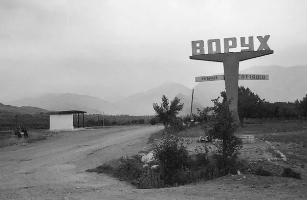
“Welcome to Vorukh.” The Kyrgyz-Tajik border in the Isfara Valley, 2004. Land shortage in Vorukh has led to extensive residential construction on the southern (Tajikistan) side of this boundary since 2004.
Contested Trajectories
To note this complexity is not to suggest that landscapes here were and are not read locally in terms of “rightful” Tajik and Kyrgyz ownership. Nor is it to deny that discussion about such ownership often animated the journey between Batken and Ak-Sai, morphing into sometimes heated debate over the primacy of claims upon, and fair access to water, land, or pastures. Local disputes over access to land and water between upstream and downstream users along the Isfara River have been a source of tension since the 1930s and have intensified considerably since the 1970s, when population growth and resettlement programs placed an acute strain on shared sources of irrigation.9 The borders between Soviet republics in this part of the Ferghana Valley were negotiated and redefined until the very last years of the USSR’s existence, as new lands were rendered habitable and new villages created in the previously unirrigated adyr zone. Tensions over rights to water and land periodically erupted into open conflict long before the reforms of perestroika enabled the more contentious consequences of Soviet modernization to be openly debated.10
The narrative recountings of such moments of transformation are striking for their discursive consistency and emotional force. Batken is a storied place (Stewart 1996)—and the stories often speak of comparisons with other places through which territorial disputes and historical grievances are rendered legible: with Palestine, with Kosovo, or with Nagorno-Karabakh. The stories of the region’s transformation differ from place to place: they are often fragmentary and inconsistent, and the heroes and victims of such accounts differ according to who is narrating and who is the audience. But in their multiple iterations such narratives serve at once to describe and reenact feelings of loss and betrayal that mirror each other across the border (see also Green 2012b; Jackson 2002). This, for instance, is how one of Ak-Sai’s first residents, sixty-two-year-old Ömürbek-Ata, recalled the process whereby Kyrgyz mountain settlements high in the Isfara Valley were consolidated into a single collective farm from the 1930s onwards:
ÖMÜRBEK-ATA: Kyrgyz people had been living up in the mountains. Bedek, you’ve seen Bedek, right, on the road going up to Keravshin and Kishemish pastures, above Tangi?11 Where there’s a border post now. There’s a river there and a little village, Bedek. It’s become a Tajik village now, but it used to be Kyrgyz land [kyrgyzdardyn jeri bolgon]. There are still two Kyrgyz cemeteries [mazar] there, one is shaped like this, the other is like that. At present the Tajiks have been moving the fences little by little, squeezing the land around the cemetery…. This place used to be all Kyrgyzstan [myna biakka polnost′iu Kyrgyzstan]. But then after the October Revolution, after 1917, people were divided into collective farms. Ours was Kolkhoz Communism. I forget the name of the Tajik one. But we were all divided into collectives. All the Kyrgyz people were grouped into one place [toptogon] and made into a kolkhoz. The Party required it. People from Bedek were gathered up, brought and joined with Tangi. They brought people from other places too…. First they were made into one farm: Kolkhoz Communism. But then all those places where people had come from were all emptied out [bul jer bosh kylat], no Kyrgyz people should live there anymore; no one should live there.
MADELEINE: Do you mean that people moved down from the mountains above Vorukh?
ÖMÜRBEK-ATA: People were brought down [köchü alyp kelgen]. The Party demanded it [Partiia zastavit kylyp]. They gathered up the Kyrgyz people into one group.
MADELEINE: By force?
ÖMÜRBEK-ATA: By force [majbur]! People were obliged to resettle. This was during the time of collectivism [kollektivizm ubagynda]. Everyone should be one collective. And then after the Kyrgyz had moved, by the 1980s, by about 1982 the Tajiks started taking over this land. It started. Vorukh was getting too full: people would have to leave in order to take care of their children. And so they started settling down on what had been our land. But the Kyrgyz couldn’t stop them. It was the Union at that time! The Union! Moscow didn’t give its permission [to contest the land seizure]. Moscow issued a decree [prikaz chygat]. It said, “the land that is being lived on now by Tajiks belongs to the Tajik [SSR]; the land being lived on now by the Kyrgyz belongs to the Kyrgyz!” So that meant the Kyrgyz couldn’t stop them [from claiming that land].
Comments such as these often came up during my journeys to, and walks through, Ak-Sai and its surroundings. Such stories would often weave together personal recollection, official history, and shared, almost mythic accounts of historical wrongdoing concerning illicit exchanges of land or the impossibility of redress in the face of decrees from Moscow.
The Batken zone is a region characterized, then, by acute constraints on shared resources, and by sometimes ardently voiced regrets that po...
Table of contents
- Acknowledgments
- A Note on Naming and Transliteration
- Introduction: On Border Work
- 1. Locations: Place and Displacement in Southern Ferghana
- 2. Delimitations: Ethno-Spatial Fixing in the Twentieth Century
- 3. Trajectories: Mobility and the Afterlives of Internationalism
- 4. Gaps: Working a “Chessboard” Border
- 5. Impersonations: Manning the Border, Enacting the State
- 6. Separations: Conflict and the Escalation of Force
- Conclusion
- Bibliography
Frequently asked questions
Yes, you can cancel anytime from the Subscription tab in your account settings on the Perlego website. Your subscription will stay active until the end of your current billing period. Learn how to cancel your subscription
No, books cannot be downloaded as external files, such as PDFs, for use outside of Perlego. However, you can download books within the Perlego app for offline reading on mobile or tablet. Learn how to download books offline
Perlego offers two plans: Essential and Complete
- Essential is ideal for learners and professionals who enjoy exploring a wide range of subjects. Access the Essential Library with 800,000+ trusted titles and best-sellers across business, personal growth, and the humanities. Includes unlimited reading time and Standard Read Aloud voice.
- Complete: Perfect for advanced learners and researchers needing full, unrestricted access. Unlock 1.5M+ books across hundreds of subjects, including academic and specialized titles. The Complete Plan also includes advanced features like Premium Read Aloud and Research Assistant.
We are an online textbook subscription service, where you can get access to an entire online library for less than the price of a single book per month. With over 1.5 million books across 990+ topics, we’ve got you covered! Learn about our mission
Look out for the read-aloud symbol on your next book to see if you can listen to it. The read-aloud tool reads text aloud for you, highlighting the text as it is being read. You can pause it, speed it up and slow it down. Learn more about Read Aloud
Yes! You can use the Perlego app on both iOS and Android devices to read anytime, anywhere — even offline. Perfect for commutes or when you’re on the go.
Please note we cannot support devices running on iOS 13 and Android 7 or earlier. Learn more about using the app
Please note we cannot support devices running on iOS 13 and Android 7 or earlier. Learn more about using the app
Yes, you can access Border Work by Madeleine Reeves in PDF and/or ePUB format, as well as other popular books in Social Sciences & Central Asian History. We have over 1.5 million books available in our catalogue for you to explore.