This successor to the classic Lefler-Newsome North Carolina: The History of a Southern State, published in 1954, presents a fresh survey history that includes the contemporary scene. Drawing upon recent scholarship, the advice of specialists, and his own knowledge, Powell has created a splendid narrative that makes North Carolina history accessible to both students and general readers. For years to come, this will be the standard college text and an essential reference for home and office.
- 670 pages
- English
- ePUB (mobile friendly)
- Available on iOS & Android
eBook - ePub
North Carolina Through Four Centuries
About this book
Trusted by 375,005 students
Access to over 1.5 million titles for a fair monthly price.
Study more efficiently using our study tools.
Information
1
NATURAL FEATURES AND NATIVE PEOPLES
THE VARIED features of the land in North Carolina have had a pronounced effect on its development. The state is usually described as being composed of three regions: the Coastal Plain, the Piedmont Plateau, and the Mountains. Each of these has a distinct history, and only in recent years have social and economic factors created a unifying force sufficient to overcome the differences and divisions long attributed to geographic influences.
One of the South Atlantic states, North Carolina is bounded on the north by Virginia, on the west by Tennessee, on the south by Georgia and South Carolina, and on the east by the Atlantic Ocean. It contains 52,712 square miles of which 49,067 are land and 3,645 are water, and ranks twenty-eighth in size among the states. From east to west North Carolina is slightly more than 500 miles, while at its widest point it is 188 miles from north to south. In elevation the range is from sea level on the Outer Banks at the Atlantic Ocean to 6,684 feet at Mount Mitchell, the highest peak east of the Mississippi River. It lies between latitudes 33°27′37″N and 36°34′25″N, and longitudes 75°27′W and 84°20′W.
The Coastal Plain
The broad, flat region of eastern North Carolina extends inland from the ocean for 100 to 150 miles and covers nearly 21,000 square miles. It is part of the vast coastal plain extending from New York southward down the Atlantic coast and around the Gulf of Mexico. The eastern limit of this region in North Carolina is the chain of long, narrow, sandy islands called the Outer Banks, extending from the Virginia state line to Bogue Inlet at the mouth of White Oak River on the Carteret-Onslow county line. The Outer Banks are separated from the mainland by several wide but shallow sounds. At Cape Hatteras, a little south of the midpoint of the Outer Banks, the land juts farther east into the Atlantic than at any other point on the North American continent south of Delaware Bay. The warm currents of the Gulf Stream in the Atlantic give Cape Hatteras and other portions of these Outer Banks a milder winter climate than they otherwise would have.
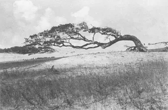
This early twentieth-century view of the North Carolina coast made by Bayard Wootten probably differs little from the isolated scene that greeted the earliest explorers of the region. (North Carolina Collection, University of North Carolina at Chapel Hill)
The Outer Banks are more than 175 miles long, and until the twentieth century, when bridges and paved highways were built, they were accessible from the mainland only by boat. Inlets through which water from some of the state’s rivers enters the ocean are frequently changed by storms. From north to south the most important inlets are Oregon and Hatteras, both opened by a hurricane on 7 September 1846, and Ocracoke which has been known since the days of the earliest explorers, although its exact location has shifted slightly with passing storms.
Of the sounds, Pamlico is the largest of the bodies of water between the Outer Banks and the mainland. It is approximately 80 miles long and ranges in width from 15 to 30 miles. It is the largest sound on the eastern coast of the United States, while Albemarle Sound is approximately 52 miles long and 5 to 14 miles wide. Other sounds in this section are Bogue, Core, Croatan, Currituck, and Roanoke.
The mainland of eastern North Carolina is level, marked by numerous swamps and lakes, and drained by many rivers and small streams. The soil is generally fertile black loam, moderately easy to farm and relatively productive. Much of this region is less than 20 feet above sea level, but along its western limits it may rise to 500 feet. The strip of eastern counties where the altitude seldom exceeds 30 feet above sea level is sometimes referred to as the Tidewater Region.
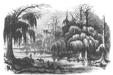
The swamps and cypress trees on the shore of Albemarle Sound were typical of much of eastern North Carolina and suggest the difficulty of passage from one part of the colony to another. (North Carolina Collection, University of North Carolina at Chapel Hill)
Along the South Carolina border an area of the Coastal Plain is somewhat higher than the adjacent section. It is called the Sandhills and covers most of Richmond, Moore, and Hoke as well as portions of Cumberland, Harnett, Montgomery, Scotland, and Lee counties, reaching an elevation of around 300 feet. In this area the pleasant winter climate has contributed to the development of Southern Pines, Pinehurst, Aberdeen, and other communities as winter resorts.
The Coastal Plain is drained by several important rivers. Flowing into the sounds are the Chowan, Roanoke, Tar-Pamlico, and Neuse rivers. The short White Oak and New rivers flow directly into the Atlantic. The Cape Fear River, formed in the Piedmont by the junction of the Deep and Haw rivers, flows through southeastern North Carolina into the Atlantic. A well-traveled waterway since the early eighteenth century, this is the state’s busiest river.
Natural lakes abound in this section of the state. In the northeast are Lake Phelps and Lake Mattamuskeet, the latter being the largest in the state with an area of 30,000 acres. Great Lake in the central east and Lake Waccamaw, White Lake, and Black Lake in the southeast are among the largest. The last three lie in an area marked by numerous smaller lakes as well as peat beds that once were lakes. Known as the Carolina Bays and particularly impressive when seen from the air, these elliptical-shaped features are believed to have been formed in prehistoric times by a shower of meteorites that pushed up a rim of sand along their southeastern rim. They are unique to this area along both sides of the line between the two Carolinas.
Eastern North Carolina, the earliest settled portion of the colony, was the scene of considerable growth as settlement pushed from north to south. After the Revolutionary War, however, the backcountry began to surpass the Coastal Plain in population and industry.
The Piedmont Plateau
The Piedmont section of North Carolina covers about 22,000 square miles. It is marked on the east by gently rolling hills with an elevation of around 500 feet and extends west to the foothills of the Blue Ridge Mountains with an elevation of around 1,500 feet. It is part of a broad belt extending from southern New York to northern Georgia. The soil of the Piedmont is frequently a sticky red clay when wet or hard and sometimes powdery dust when dry. Rocks of varying size, even up to large immovable boulders, are common here. Farmers have found the soil in the Piedmont to be more difficult to work and usually less fertile than that of the east; as a result, farms traditionally have been smaller here.
Rivers and other streams of the Piedmont often flow through deep cuts made in the clay soil. Their steep banks sometimes fill rapidly during heavy rains when excess water drains off the surrounding countryside. The chief rivers of this section are the Catawba and the Yadkin-Pee Dee, both of which rise in the mountains and flow southeast into South Carolina. Many smaller streams, swift and shallow, have been dammed to produce waterpower to operate mills. Numerous gristmills sprang up in the Piedmont soon after settlers arrived, and the first cotton mill south of the Potomac River was erected in Lincoln County on the banks of a small stream, which provided ample power.
Dams erected on the rivers and streams of the Piedmont in the twentieth century impounded waters that made large lakes of considerable importance for recreation, flood control, or the production of hydroelectric power. Among them are Lake Gaston, Kerr Lake, Lake Hickory, Lake James, and Lake Norman. The face of the Piedmont has been changed from a country of small farms to a growing industrial region. The Piedmont Crescent extending from Wake County on the east through the cities of Raleigh and Durham and across Orange, Alamance, Guilford, Randolph, Forsyth, Davidson, Rowan, Cabarrus, Mecklenburg, Gaston, and Lincoln counties is an almost continuous strip of industrial activity through the heart of the Piedmont.
The Piedmont also is marked by some unusual features. The Uwharrie Mountains extending northeast-southwest across Montgomery, Randolph, and Stanly counties have peaks rising to nearly 1,800 feet above sea level. Kings Mountain in Cleveland and Gaston counties extends down into South Carolina, but its highest point, The Pinnacle, at the northern end, has an altitude of 1,705 feet. A few miles away in Burke, Cleveland, and Rutherford counties are the South Mountains with several impressive peaks, the tallest of which is High Peak with an altitude of 2,720 feet. In the Sauratown Mountains of Stokes County, Moore’s Knob is 2,579 feet. Pilot Mountain in southeastern Surry County, an isolated peak standing alone in generally flat country, is 2,700 feet above sea level, but it stands 1,500 feet above the countryside, serving as a landmark, a “pilot,” visible from a great distance away.
While North Carolina was still its colony, England recognized the Piedmont as a potential source of profit. In 1767 an English writer described it as being more fruitful and healthy than the east; once “peopled and secured,” he predicted, it would become a significant part of the “British dominions” and of “service to the nation.” From this region, he believed, would come people to settle up the Mississippi and across the continent to “the territories of the Ohio.” Time proved him correct, but only after independence was achieved.
The Mountains
The mountainous region of western North Carolina covers approximately 6,000 square miles and ranges in elevation from around 1,500 feet on the east to 6,684 feet a few miles northeast of Asheville at Mount Mitchell. In North Carolina this region is about 200 miles long and ranges in width from 15 to 50 miles. The mountains here are a part of the Appalachian system, which extends from Canada into northern Alabama but attains its greatest height and mass in North Carolina. The eastern limit of the section is marked by the Blue Ridge, the eastern continental divide, while the Great Smoky Mountains mark the division between North Carolina and Tennessee on the west. The average elevation of the Blue Ridge is 4,000 feet, but there are passes that sink as low as 2,000 feet above the level of the Piedmont. There are 49 peaks in the state’s mountains with an elevation in excess of 6,000 feet, and 174 exceed 5,000 feet; hundreds are between 4,000 and 5,000 feet. In many areas this is extremely rugged country marked both by the main ridge running northeast-southwest and by lesser spurs shooting off to the east and west from them. On the streams of the mountains occur numerous waterfalls, many of which have intriguing names such as Bear Wallow, Raven Cliff, Bridal Veil, Whitewater, Soco, and Cullasaja. In some cases the water of these falls plunges into a deep pool over 1,300 feet below, while others tempt the visitor to slide down the smooth rock over which the water glides.
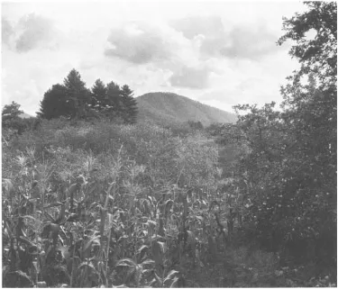
A view in the mountains of western North Carolina with an unimproved variety of corn in the foreground, an old-fashioned apple tree on the right, and some wildflowers in the lower right corner. This photograph was made in the early twentieth century by Bayard Wootten, noted North Carolina artist-with-a-camera. (North Carolina Collection, University of North Carolina at Chapel Hill)
Rainfall on the eastern slopes of the Blue Ridge drains into the Atlantic Ocean through streams which rise in that region. Most of them then flow through the Piedmont and across South Carolina where they enter the Atlantic Ocean. On the western slopes water drains into the Gulf of Mexico through tributaries of the Mississippi River that rise in the mountains of western North Carolina. Chief among these are the Hiwassee, Little Tennessee, French Broad, Nolichucky, Pigeon, Elk, and Watauga rivers. The New River, however, formed on the Ashe-Alleghany county line, flows north; it is said to be the only large river in the United States to flow in this direction.
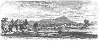
With Mount Pisgah in the distance on the Buncombe-Haywood county line, gently sloping grassland on the right, and a field on the left enclosed by a rail fence, this nineteenth-century view was intended to suggest that western North Carolina was a region of great beauty. (North Carolina Collection, University of North Carolina at Chapel Hill)
Many valleys formed by the mountain streams are deep and narrow, and of the numerous waterfalls many are high and spectacular. The narrow defile through which Linville River flows in northwestern Burke County has been acclaimed the wildest gorge in the eastern United States. The New River, so called because it was discovered comparatively recently, is also in a wild and isolated section in the northwestern corner of the state. It is considered to be the second oldest river in the world, next after the Nile. In its waters and along its banks live fish and plants not known elsewhere.
With the creation of the Tennessee Valley Authority in 1933, many rivers of the North Carolina mountains were harnessed for the production of electricity. Among the lakes formed by dams are Chatuge, Fontana, and Hiwassee. Numerous smaller ones, some formed prior to 1933, also dot the region. In addition to power, these waters provide the means of flood control, recreation, and excellent fishing, and are sources of municipal water.
Many of the peaks in the Great Smoky Mountains are marked by balds. These are areas without trees, sometimes several thousand acres in size, usually above the 5,000-foot mark, and covered with thick native grass. The soil is black and deep, and almost invariably small springs may be found near the edges. No satisfactory explanation of the origin of the balds has been presented, but often landslides, fires, storms, and the direction of the prevailing winds have been credited with their formation.
The mountains were first explored by Europeans when a Spanish expedition under Hernando de Soto arrived in 1540. He reported the area to be pleasant and spent a month resting his horses and enjoying the hospitality of the natives. The region has been a popular resort since it first became accessible by road and rail. Many visitors enjoy the mild summer climate, long climbing expeditions, and the search for wildflowers and gemstones. The Appalachian Trail, a noted hiking route, passes through the region and brings many visitors as does the lure of ski slopes and some noted caves, particularly Linville Caverns and Bat Cave.
The Influence of Geography
A North Carolina historian, Christopher Crittenden, once wrote: “When Nature came to design the topography of eastern North Carolina, she almost persuaded herself to create a great maritime center.” But this she did not do. The inlets and sounds along the coast are shallow and shifting. Nature intended instead that North Carolina should be first an agricultural region—soil and climate dictated this. Sources of power spurred the later development of industry in the backcountry, settled about a century later.
The lack of good harbors meant that few settlers would come directly to North Carolina from abroad. Many made their way to the Carolina frontier from Charles Town,1 Norfolk, or Philadelphia, if they were recent arrivals from England or the Continent. Most, however, had been born and spent a part of their life in one of the other colonies (or states).
The course of the rivers in the Piedmont channeled traffic, which used their waters or the roads along their level banks, not to the towns of the Coastal Plain but into South Carolina. The Dan River carried trade into Virginia. The lack of deepwater ports along the coast forced the delivery of much produce to the markets of Virginia and South Carolina. Isolation and sectionalism played important roles in the development of North Carolina. Sectional conflicts occurred in the colony several times. Hardly a movement or an event can be described without reference to geographic factors.
Geology
The state consists of only two basic geologic regions. The eastern region coincides with the Coastal Plain where the soil is composed of sand and a black clay varying in thickness from ten to forty feet in belts ten to fifteen miles wide. Examination of the subsurface reveals “marine terraces” underlying the region. Seven of these terraces exist in the state. Each was once the coasdine. Evidence of these terraces can be seen in the steep banks of the Cape Fear River near Fayetteville, the Neuse River between Goldsboro and Kinston, and the Roanoke River east of Scotland Neck. These terraces began to be formed around 125 million years ago.
As the sea retreated, pockets of water remained and to these marine life retreated. The water finally evaporated or seeped into the earth, leaving shells and bones to form marl beds. Such beds exist in at least twenty-five Coastal Plain counties, and they have long been a source of lime for farms in the region. For generations, children in many parts of eastern North Carolina have delighted in finding sharks’ teeth along the banks of many streams after heavy rains washed away the topsoil.
The Piedmont and Mountain regions comprise the second geologic region. Mountains once covered much of the Piedmont and their worn-down remains are known as the Uwharrie, Kings, and Pilot mountains. Some of the mountains that once existed in the Piedmont were formed by volcanic action. Many hills in Orange, Caswell, and Granville counties were formed in this manner. The Piedmont and Mountain sections, as they now exist, are the result of some 500 million years of evolution.
In addition to the shells and bones and the sharks’ teeth, other fossils have been found throughout the state; these reveal much about the region in ancient times. Among the very oldest fossils discovered in North Carolina are a few teeth and bones, including jaws, of mammal-like reptiles from the Triassic period, 180 million years ago, in the Dan River and the Deep River basins. By the Cretaceous period, which began around 125 million years ago, magnolia, sassafras, poplar, and fig trees were growing here. These are among the oldest plant fossils found in the state. By the ...
Table of contents
- Cover Page
- NORTH CAROLINA THROUGH FOUR CENTURIES
- Copyright Page
- Dedication
- CONTENTS
- PREFACE
- 1 NATURAL FEATURES AND NATIVE PEOPLES
- 2 EXPLORATION AND EARLY SETTLEMENT
- 3 A PROPRIETARY COLONY, 1663–1729
- 4 ROYAL GOVERNMENT
- 5 COLONIAL SOCIETY AND CULTURE, 1729–1776
- 6 COLONIAL ECONOMY: AGRICULTURE, TRADE, AND COMMUNICATION
- 7 SECTIONAL CONTROVERSIES IN THE COLONY
- 8 A DECADE OF DISPUTE
- 9 ATTAINING INDEPENDENCE
- 10 A FREE STATE
- 11 A JEFFERSONIAN REPUBLIC
- 12 A STATE ASLEEP
- 13 THE VISION OF ARCHIBALD D. MURPHEY
- 14 THE CONSTITUTIONAL CONVENTION OF 1835
- 15 THE WHIG ERA, 1835–1850
- 16 A CHANGE IN MIDSTREAM
- 17 THE ECONOMY AND ANTEBELLUM SOCIETY
- 18 THE COMING OF THE CIVIL WAR
- 19 THE CIVIL WAR
- 20 A STATE MADE NEW
- 21 A FRESH START
- 22 A TIME OF READJUSTMENT
- 23 GREAT ANTICIPATIONS FOR THE TWENTIETH CENTURY
- 24 DOWN BUT NOT OUT: THE STATE SURVIVES THE GREAT DEPRESSION
- 25 NEW POINTS TO PONDER IN A RESTLESS WORLD
- 26 A NEW FACE FOR THE STATE
- 27 THE STATE LOOKS TO THE FUTURE
- APPENDIXES
- FURTHER READING
- INDEX
Frequently asked questions
Yes, you can cancel anytime from the Subscription tab in your account settings on the Perlego website. Your subscription will stay active until the end of your current billing period. Learn how to cancel your subscription
No, books cannot be downloaded as external files, such as PDFs, for use outside of Perlego. However, you can download books within the Perlego app for offline reading on mobile or tablet. Learn how to download books offline
Perlego offers two plans: Essential and Complete
- Essential is ideal for learners and professionals who enjoy exploring a wide range of subjects. Access the Essential Library with 800,000+ trusted titles and best-sellers across business, personal growth, and the humanities. Includes unlimited reading time and Standard Read Aloud voice.
- Complete: Perfect for advanced learners and researchers needing full, unrestricted access. Unlock 1.5M+ books across hundreds of subjects, including academic and specialized titles. The Complete Plan also includes advanced features like Premium Read Aloud and Research Assistant.
We are an online textbook subscription service, where you can get access to an entire online library for less than the price of a single book per month. With over 1.5 million books across 990+ topics, we’ve got you covered! Learn about our mission
Look out for the read-aloud symbol on your next book to see if you can listen to it. The read-aloud tool reads text aloud for you, highlighting the text as it is being read. You can pause it, speed it up and slow it down. Learn more about Read Aloud
Yes! You can use the Perlego app on both iOS and Android devices to read anytime, anywhere — even offline. Perfect for commutes or when you’re on the go.
Please note we cannot support devices running on iOS 13 and Android 7 or earlier. Learn more about using the app
Please note we cannot support devices running on iOS 13 and Android 7 or earlier. Learn more about using the app
Yes, you can access North Carolina Through Four Centuries by William S. Powell in PDF and/or ePUB format, as well as other popular books in History & North American History. We have over 1.5 million books available in our catalogue for you to explore.