The perfect companion to any flight - a guide to the science on view from your window seat. There are few times when science is so immediate as when you're in a plane. Your life is in the hands of the scientists and engineers who enable tons of metal and plastic to hurtle through the sky at hundreds of miles an hour. Inflight Science shows how you stay alive up there - but that's only the beginning. Brian Clegg explains the ever changing view, whether it's crop circles or clouds, mountains or river deltas, and describes simple experiments to show how a wing provides lift, or what happens if you try to open a door in midair (don't!). On a plane you'll experience the impact of relativity, the power of natural radiation and the effect of altitude on the boiling point of tea. Among the many things you'll learn is why the sky is blue, the cause of thunderstorms and the impact of volcanic ash in an enjoyable tour of mid-air science. Every moment of your journey is an opportunity to experience science in action: Inflight Science will be your guide.
- 224 pages
- English
- ePUB (mobile friendly)
- Available on iOS & Android
eBook - ePub
About this book
Trusted by 375,005 students
Access to over 1.5 million titles for a fair monthly price.
Study more efficiently using our study tools.
Information
Subtopic
Applied SciencesAbove the Clouds
Into the clouds
So far the view has been superb. But at some point on the journey you’re likely to pass into cloud. From inside the plane it will look as if it has become foggy outside, but eventually you will break out above the clouds to see an astounding cloudscape around you. In the daytime, up above the clouds, the Sun is always shining and the sky always blue. Below might lie a ruffled eiderdown of clouds, presenting a majestic spectacle as they stretch to the horizon.
There are a number of different cloud types you might notice as you pass through and above them, but before looking at them in detail, we need to find out just what a cloud is. There’s always water vapour in the air. We tend to think of the jet of steam that emerges from a kettle as water vapour, but this is misleading. Water vapour is an invisible gas, the gaseous form of water, just as ice is its solid form. What we see as steam is water vapour that has condensed back to a liquid, forming tiny droplets in the air.
We know that water boils at 100°C, so it might seem odd that there’s always water vapour in the air, even at room temperature. Just imagine the sea, as the world’s main source of water vapour, at normal temperature. What we mean by temperature is a measure of the speed of the molecules in a substance. The faster the molecules move, the higher the temperature. But temperature is a matter of statistics. It doesn’t tell us that every molecule is moving at the speed you’d expect for this temperature, but rather that on average their speed will be the one that corresponds to this temperature.
In practice, some molecules will be moving much slower, some much quicker, than the average. Compared to the water molecules below the surface, the molecules on the surface of the sea that are moving at high speed have a better chance of moving further before they hit another molecule. Some will travel so fast that they can escape from the electromagnetic attraction of the other molecules in the ocean and head off into the atmosphere. If all the molecules in the sea were travelling this fast, it would boil. As it is, it’s always losing a few molecules at a time – evaporating – which over the vast surface of all the oceans makes for a whole lot of water vapour.
So water molecules are shooting off as vapour all the time. At the same time, water molecules in the air drop back into the ocean. In any particular set of conditions there will be an equilibrium between water evaporating into vapour and condensing back into liquid. The amount of water vapour in the air is measured by its humidity.
Some of the water molecules will clump together in the air and become tiny droplets of liquid – or higher up, where it’s colder, minuscule crystals of ice. These droplets can form due to a temperature change, but are often seeded by floating particles like grains of dust, smoke or pollen. This even happens with bacteria – there are billions of bacteria in the air, which seem to be responsible for producing a lot of this water condensation. The suspended water droplets, like the droplets you see emerging as steam from the kettle, form a cloud.
An obvious question that’s rarely answered is, why don’t clouds fall out of the sky? After all, water is heavier than air. It doesn’t float around if you spill it out of a glass. Of course, water falls from the sky as rain, but why don’t the clouds drop out of the sky to land as puddles?
The surprising answer is that clouds do sink. There’s nothing magic about them – they have to respond to gravity like everything else. But they sink very, very slowly. It’s because the droplets of water are so ridiculously small – as little as 1/100,000,000th of a metre across. At this scale, objects don’t behave as we expect them to. Although the drops are subject to exactly the same forces as are visible drops of water, the relative impact of those forces changes.
The force of gravity, dependent on the drop’s mass, gets less and less. Meanwhile, the smaller the object, the more influence air resistance will have. Because the droplets are much closer in size to an air molecule than is a raindrop, they are much more battered around by the constant impact of the air. To a droplet of water in a cloud, the air is like very thick treacle is to a small ball bearing. It would take one of our tiny droplets over a year just to drop one metre. In practice, clouds don’t stay around long enough to be seen to fall.
Clouds can appear in a range of colours. By default they are white, because they reflect a lot of light – but fuzzily, like ice, rather than directly like a shiny metal. Thinner clouds can pick up colours from the sky, particularly around sunset or sunrise, when red clouds are quite common. Others will be significantly darker, ranging from greys to what appears to be black.
In practice, they will never be darker than grey, but our eye/brain combination can make them look darker than they really are. You can see this effect when you look at a picture of the night sky or space on your TV. They look black – but your screen can’t get blacker than it is when the TV is switched off, and that’s dark grey. Your brain fools you into thinking the screen is black.
The darkening of clouds happens as the droplets in the cloud join together to form bigger drops. This means that light is less likely to be reflected from the surface, and some colours get absorbed, giving a darker colour. We tend to associate dark clouds with storms because the drops need to accumulate together, getting bigger, before they can fall as rain.
An adventure in cloud-spotting
Clouds are divided by type. These correspond both to the height at which the cloud is located and the shape and density of the cloud. (Technically, the types also include how the cloud moves and changes shape, but we can get away without this for the basics.) These different types are useful for weather forecasting, but also give a lot of pleasure from simply observing them. There are technically a great number of cloud types – around 52 – but for our purposes we can simplify them to ten categories. The original classification identified three families of clouds. These were cirrus (from the Latin for ‘hair’ – hence wispy, thin clouds), cumulus (meaning a ‘heap’ or ‘pile’ for obvious reasons), and stratus (meaning a ‘layer’ or ‘sheet’ – again, pretty obvious).
This early structuring was done in 1802 by a pharmacist and amateur meteorologist from London, Luke Howard, and picked up by the likes of landscape painter John Constable, who produced reams of cloud studies. Later, in 1896, the clouds were grouped into nine basic forms, each given a number from 1 to 9. This was later revised to include ten cloud forms – 1 to 10. But the World Meteorological Organization (WMO), the body responsible for the numbering, later changed the range again to be 0 to 9.
This final change of numbering was for a surprisingly romantic reason. The cloud type with the number 9 (which later briefly became 10) was the cumulonimbus. Although this is classified as a low cloud because its base starts well down, the peaks of a giant cumulonimbus climb higher than any other cloud. If you were perched on top of a cumulonimbus you could consider yourself on top of the world – and this is where the expression ‘on cloud 9’ comes from. The WMO realized they were being spoilsports turning a cloud 9 into a cloud 10, so they reversed their decision.
All the way to cloud 9
Let’s take a look at the clouds you’re likely to be able to see and recognize from your plane window. The lowest of the low is the stratus. These are the sheets of cloud that can look like a layer of mist starting suddenly above a certain level (mist and fog reach the ground – clouds don’t), or a uniform grey blanket of cloud. A variant called stratus fractus is broken into shreds that descend further than the main body of the cloud. Stratus can occur just a few hundred metres over ground level, when you hit cloud almost immediately after take-off.
The second low cloud type – often a favourite when cloud-watching from the ground – is the cumulus. This is the standard cloud portrayed by children making a collage, represented so easily by a clump of cotton wool. With bases around 600 metres and above, cumulus clouds form as a result of thermals, rising columns of warm air that are produced when the Sun heats up the ground. These air columns carry both the water vapour and pollen and bacteria, acting as seeds to trigger cloud formation.
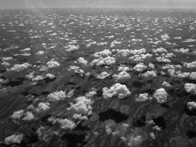
21. A flock of cumulus clouds from above.
Cumulonimbus can start at a similar height, but they go up much further (and have to if they’re going to be a cloud 9, as they can also, in a smaller variant, be cloud 3). They can rise as far as 18 kilometres, nearly twice the altitude your plane will cruise at. The top part of a cumulonimbus is more wispy than the bottom, and the whole cloud often forms in an approximate anvil shape, producing the typical ‘thunderhead’.
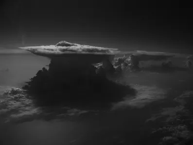
22. A large thunderhead cumulonimbus.
Last of the low clouds is the stratocumulus. One variant of these can form as a cumulus rises and thins out, looking as if that clump of cotton wool has been stretched until it fragmented. But the most common form – in fact the most common type of cloud altogether – makes a broken or striated layer, at its most friendly like a thin sheet of cotton wool that has been stretched until it has lots of gaps, but potentially considerably thicker and more uniform, where it’s like a higher stratus with more texture.
_opt-plgo-compressed.webp)
23. A stratocumulus layer seen from below.
When we reach the mid-level clouds, it’s no surprise that altostratus are like a higher version of stratus, a thin sheet of cloud with few discernible features. They may be thin enough to show the Sun through as a clear shape, or more opaque. The thicker variety is a pretty sure source of rain and has a miserable look to it. It typically lies between 1,000 and 2,000 metres up – still early in the climb of an aircraft through the cloud layers. The thicker variety also comes under a second name of nimbostratus – it switches from altostratus to nimbostratus when it begins to rain. (A nimbus is a rain cloud.)
Altocumulus may be a higher form of cumulus, but it has more visual similarities to stratocumulus, producing shredded sheet effects, sometimes in linear bands.
Finally we reach the high clouds, the ones you’re likely to be flying up with (alongside the tops of large cumulonimbus). By the time you reach this height, typically above the 20,000 feet (6,000 metre) mark, clouds are almost entirely made of ice crystals rather than water droplets. You will often meet the cirrus – wispy filaments of cloud that form strands across large areas of sky. Traditionally, cirrus clouds shaped like a comma with a more blobby end have been regarded as a warning of strong winds to come when they stretch out to form long filaments. These ‘mares’ tails’ do often reflect weather that is about to become more unsettled.
Another high cloud, forming over 6 kilometres up like the cirrus, is cirrostratus. This forms more of a sheet than the cirrus, often with clear leading edges. Cirrostratus is often accompanied by cirrus clouds, but covers a significantly greater solid area.
Finally we have the cirrocumulus. Again high in the sky – sometimes as high as 14 kilometres – theses clouds are often striated, with a ‘herringbone’ pattern. They can be broken up more, looking like very high stratocumulus.
As we’ve seen, there are plenty of variants of these clouds, plus a range of oddities like mamma – sometimes described as udder-like protuberances that form under stratocumulus and cumulonimbus when there’s a strong down-draft. (To see them as mammaries requires a fair amount of imagination – they could equally be described as rounded scales.)
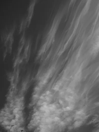
24. Wispy cirrus clouds from below.
No...
Table of contents
- Cover
- Title page
- Copyright
- Contents
- List of illustrations
- About the author
- Disclaimer
- Dedication
- At the airport
- Taking to the sky
- Exploring the landscape
- Above the clouds
- Cabin life
- Technology in flight
- Distant views and back to earth
- Picture Credits
Frequently asked questions
Yes, you can cancel anytime from the Subscription tab in your account settings on the Perlego website. Your subscription will stay active until the end of your current billing period. Learn how to cancel your subscription
No, books cannot be downloaded as external files, such as PDFs, for use outside of Perlego. However, you can download books within the Perlego app for offline reading on mobile or tablet. Learn how to download books offline
Perlego offers two plans: Essential and Complete
- Essential is ideal for learners and professionals who enjoy exploring a wide range of subjects. Access the Essential Library with 800,000+ trusted titles and best-sellers across business, personal growth, and the humanities. Includes unlimited reading time and Standard Read Aloud voice.
- Complete: Perfect for advanced learners and researchers needing full, unrestricted access. Unlock 1.5M+ books across hundreds of subjects, including academic and specialized titles. The Complete Plan also includes advanced features like Premium Read Aloud and Research Assistant.
We are an online textbook subscription service, where you can get access to an entire online library for less than the price of a single book per month. With over 1.5 million books across 990+ topics, we’ve got you covered! Learn about our mission
Look out for the read-aloud symbol on your next book to see if you can listen to it. The read-aloud tool reads text aloud for you, highlighting the text as it is being read. You can pause it, speed it up and slow it down. Learn more about Read Aloud
Yes! You can use the Perlego app on both iOS and Android devices to read anytime, anywhere — even offline. Perfect for commutes or when you’re on the go.
Please note we cannot support devices running on iOS 13 and Android 7 or earlier. Learn more about using the app
Please note we cannot support devices running on iOS 13 and Android 7 or earlier. Learn more about using the app
Yes, you can access Inflight Science by Brian Clegg in PDF and/or ePUB format, as well as other popular books in Technology & Engineering & Applied Sciences. We have over 1.5 million books available in our catalogue for you to explore.