eBook - ePub
Available until 23 Dec |Learn more
Imaging the City
Art, Creative Practices and Media Speculations
This book is available to read until 23rd December, 2025
- 196 pages
- English
- ePUB (mobile friendly)
- Available on iOS & Android
eBook - ePub
Available until 23 Dec |Learn more
Imaging the City
Art, Creative Practices and Media Speculations
About this book
Imaging the City brings together the work of designers, artists, dancers and media specialists who cross the borders of design and artistic practices to investigate how we perceive the city; how we imagine it; how we experience it; and how we might better design it. Breaking disciplinary boundaries, editors Steve Hawley, Edward Clift and Kevin O'Brien provocatively open up the field of urban analysis and thought to the perspectives of creative professionals from non-urban disciplines. With a cast of contributors from across the globe, Imaging the City offers international insight for engaging with – and forecasting the future for – our cities.
Frequently asked questions
Yes, you can cancel anytime from the Subscription tab in your account settings on the Perlego website. Your subscription will stay active until the end of your current billing period. Learn how to cancel your subscription.
No, books cannot be downloaded as external files, such as PDFs, for use outside of Perlego. However, you can download books within the Perlego app for offline reading on mobile or tablet. Learn more here.
Perlego offers two plans: Essential and Complete
- Essential is ideal for learners and professionals who enjoy exploring a wide range of subjects. Access the Essential Library with 800,000+ trusted titles and best-sellers across business, personal growth, and the humanities. Includes unlimited reading time and Standard Read Aloud voice.
- Complete: Perfect for advanced learners and researchers needing full, unrestricted access. Unlock 1.4M+ books across hundreds of subjects, including academic and specialized titles. The Complete Plan also includes advanced features like Premium Read Aloud and Research Assistant.
We are an online textbook subscription service, where you can get access to an entire online library for less than the price of a single book per month. With over 1 million books across 1000+ topics, we’ve got you covered! Learn more here.
Look out for the read-aloud symbol on your next book to see if you can listen to it. The read-aloud tool reads text aloud for you, highlighting the text as it is being read. You can pause it, speed it up and slow it down. Learn more here.
Yes! You can use the Perlego app on both iOS or Android devices to read anytime, anywhere — even offline. Perfect for commutes or when you’re on the go.
Please note we cannot support devices running on iOS 13 and Android 7 or earlier. Learn more about using the app.
Please note we cannot support devices running on iOS 13 and Android 7 or earlier. Learn more about using the app.
Yes, you can access Imaging the City by Steve Hawley, Edward Clift, Kevin O'Brien, Steve Hawley,Edward Clift,Kevin O'Brien, Graham Cairns in PDF and/or ePUB format, as well as other popular books in Politics & International Relations & Architecture General. We have over one million books available in our catalogue for you to explore.
Information
Edition
1Subtopic
Architecture GeneralSection One
Theories of Media, Memory and Imagination
Chapter 1
Territories of image: Disposition and disorientation in Google Earth
Introduction
The image of the city today is fraught. In the past, the image has been understood as fundamental to our cognitive apprehension of the city, to the expression of its meaning, and to our imagination of its future. Today its image may have entered new territory, increasingly technologized – and commodified – in a transformation that seems to enable these longstanding roles of the urban image, but might also shut them down. The following pages attempt to understand that new condition by examining urban and geographical images harvested from Google Earth, images interesting for their content – patterns of development, occupation and land use, urban infrastructure, built environments and landscapes – but also their form – as media-based archives of time and space. This chapter attempts to sketch out what we might find interesting in such images, by drawing on Keller Easterling’s ideas on infrastructure, and Bernard Stiegler’s on the industrialization of knowledge.
Conditions of media today pose specific challenges to those who design cities, their landscapes and their buildings. The designer’s means of visualizing and imagining her works have become highly systematized and industrialized in frameworks: frameworks whose use is essential to the work of any designer who does not want to be professionally marginalized. They include software suites, mostly proprietary, for the creation and processing of images and models; platforms for the capturing of images and design-related information, for example Geographic Information Systems (GIS); resources for storing and transmitting knowledge about a vast array of industrial products and processes; and technical and legal protocols for the transposition of these ideas into technical drawings, contract documents, and from there into built form. Such frameworks of (very often visual) knowledge dovetail with analogous systems structuring the production and design of space: industrial standards, building codes, zoning documents, policy frameworks, systems of construction and materials delivery. The new imaging technologies can be powerful tools of documentation, research and visualization. But their power harbours a danger also: like the tools of city-making, the tools of city-imag(in)ing imply an engagement in massive and immensely-scaled technological networks that commodify the image even as they make it available to us. Today a key question for a designer is how she might seek out agency within machinery of such scale and complexity; how she might find space and respite from, even within, this flood of instantaneous and systematized information.
Google Earth epitomizes these new technologies of imaging and image delivery. They provide extensive and rapidly updated visual documentation in an intuitive graphical user interface (GUI), with much of the imaging crowdsourced, a great deal of it algorithmically generated and all of it available for free – or more precisely, at the cost of the commodification of the user’s own usage patterns. As a popular and relatively accessible form of GIS, Earth is a useful tool for harvesting information about urban space, as well as (in inter-operation with 3D modelling tools) the visualization and design of architecture and urban areas.
The still images reproduced here are drawn from a set of visual artworks which attempt to critically address such imaging systems and their engagement of the planet. These works were/are original works of screencaptured and projection-mapped video, originally harvested at HD resolution. The stills reproduced here have been recaptured at a much higher resolution for print publication, and they are direct captures from Google Earth Pro; they have not been manipulated or Photoshopped. It matters to the original pieces that they are composed of moving images; they record a slow progression across the Earth’s surface and project a liquid patina onto the materiality of architecture. But to focus the analysis, this chapter will address only stills.
The original video projects might be understood in the context of a growing number of artists who employ aerial, satellite and ‘street view’ images in their practices; for example, Mishka Henner and Jon Rafman. One of the videos cited here, Transect (Bird 2014), tracked the Prime Meridian and Antemeridian in a full circuit of the planet; the second, Edge (Bird 2015), follows the municipal boundary of Winnipeg, a Canadian city which problematizes the definition of ‘the urban’ at a number of levels. Transect was a projection mapped on the courtyard facade of the Queen Anne Court at the Royal Naval College in Greenwich, England, in August and September of 2014. Edge is an ongoing project. The two form part of a trilogy with parallel (Bird 2013), a work tracking the 49th latitude, the border between western Canada and the United States; parallel was installed in the group show ‘Movable Borders’ at Furtherfield Gallery, UK (2013). Each of these works follows an arbitrary political or locational line across the surface of the earth, a gesture which suggests submission to technical mapping systems and all that they imply. However, rather than revealing anomalies in digital imagery of the earth and its landscapes, the projects aim instead for a critical undermining of attempts to organize the world and render it up to scientific, political and economic ends – direct and indirect articulations of the Enlightenment project. Google’s Earth finds its origins in that project, as do the infrastructures that preoccupy Easterling; and the industrialization of memory discussed by Stiegler is the most current development of that project.
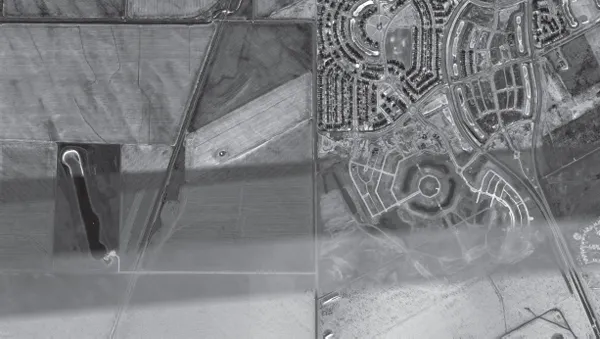
Figure 1. Lawrence Bird, Edge (2015). Video stills. Courtesy of Google Earth. © 2015 Digital Globe.
Disposition
The first image we will address is taken from the project Edge, which traces the municipal boundary of a prairie city (Figure 1). To the left we can see the farmland beyond the city limits; to the right, a new housing development begins to fill the urban landscape. As do other forms of GIS, this image and its attendant data can provide technically useful information. But the video is more interesting on other levels. Harvested with Earth’s ‘historical imagery’ function toggled on, it splices together several images captured at different points in time – different seasons over several years and, as it happens, at different stages in the development of the cityscape. Stiegler will help us understand the engagement with time implied by images like these; but before we turn to his work, we will look briefly at how they articulate properties of the contemporary city identified and discussed by Easterling.
Easterling describes a city, even a planet, defined by infrastructure. She describes the complex overlay of regulations, standards and protocols that create our environments today in terms of disposition. Disposition is the tendency of the infrastructure of any environment to push us, and to push the growth of the city, in one direction or another. It is a contemporary realization of the modern infrastructural paradigm based on technical efficacy and, through that, the achievement of economic and political ends. Our cities bear witness to early and contemporary iterations of this phenomenon: rail lines dating from the nineteenth century; and roadways, industrial zones and housing subdivisions dating from our own time. These spaces are cultural, experiential, and political, and they influence, if not determine, our social lives: ‘Like an operating system managing activities in the background, space is a technology, a carrier of information, and a medium of polity’ (Easterling 2014: 240).
For Easterling this operating system is governed by rules which are today not proper to nations, or to international alliances of nations, but to transnational agencies governing the technical parameters of infrastructure – for example, telephony in Africa, or more globally the protocols imposed by the International Standards Organization (ISO). These protocols generate tendencies that dispose the environment towards certain possibilities, often indirectly and apparently without intention. Infrastructure is thus not passive; it has a form of agency; and it promotes a form of polity. Easterling examines specifically the creation of quasi-autonomous zones as enclaves in cities around the world – from Canary Wharf in the United Kingdom to Guangdong in China. In these spaces, laws are suspended in the sense that Giorgio Agamben has discussed: human beings are reduced to sub-human status; democratic governance is superseded by governance on behalf of multinational corporations (Agamben 1998).
While disposition serves political and economic agendas, its control is far from absolute; it is in its own turn malleable. For Easterling, the skill of an urbanist lies in detailing and developing the active forms that shape and constitute disposition. These include multipliers (elements which multiply throughout an environment influencing its form: from tract houses to cell phones); switches (elements which serve as gateways and tipping-points in processes: highway interchanges for example); topologies (frameworks across which messages can move in specific ways: the city grid); and governors (growth protocols: plans and zoning guidelines). We can identify some of these active forms in Figure 1, in which the suburban tract homes are caught in the act of multiplying across a landscape governed by political divisions, zoning regulations, industry standards and strategies of infrastructural layout. The new development creates a topology that will guide circulation and social relationships, and that is in many ways oblivious to the topologies that preceded it; it represents a radical change in disposition, though perhaps sharing a pragmatic attitude towards the commodification of land.
Easterling makes the case that as a designer works on the placement and orientation of such active forms in a dispositional system, she is a performer whose first task is to activate a number of corollaries or counterparts to infrastructural disposition that offer the potential of departure from its scripts and agendas. These, Easterling says, explicitly undermine the technical optimization that infrastructures ostensibly have as their aim. These departures are, paradoxically, built into the movement towards standardization; as evidence of this she offers the observation that the more rationalized the spatial products of infrastructure become, the better suited they seem to be to the irrational fictions of branding. Even infrastructural protocols themselves evince this tendency: Easterling gives as an example the flagship standard ISO 9000. This protocol refers not to any technical standard of any product, but to the organization of the company that produces it – its quality in terms of internal organization and client service. As such it is less standard than it is ‘superbrand’ (Easterling 2014: 178). For Easterling, the management fads and gurus which have sprung up around the search for ‘quality’ are further evidence of how standardization (in the form of corporatization) slips into fantasy (Easterling 2014: 193).
Developing this notion, she discusses infrastructural systems’ tendency to generate and support master narratives: narratives which structure a world-view. Totalizing world-views and the stories that buttress them also tend to be characterized by contradiction. They can, for example, include narratives of intellectual property and, within the same technological trajectory, narratives of sharing; narratives that are both technological and quasi-religious (from the cults of Saint-Simonianism to Apple); and narratives of freedom (from regulation) that promote slavery (to labour forces) (Easterling 2014: 207). In other words, the infrastructural instrumentalization of the world paradoxically generates fantasies; it seems to generate (rather than eliminate) narrative, and those narratives are rife with contradictions.
Dissensus, discrepancy
Easterling identifies two means by which the contradictions inherent in such stories can be exploited to disrupt disposition: dissensus and discrepancy. These exploit the contradictions already noted. The first refers to contradictory or inadmissible evidence inherent in the scripting of space or structure: ‘Space can embody dissensus when it scripts an interplay for multiple opposing or counterbalancing players and when it returns to that game of the laws and people that the market has erased or excluded for its convenience’ (Easterling 2014: 235).
Dissensus exploits parallel scripts and players to empower those disenfranchised by the system. Discrepancy is related, and refers to ‘the misregistration between stated intentions and undeclared activity [that] makes more palpable active forms and the underlying dispositions they shape’ (Easterling 2014: 240). For Easterling, as infrastructures and their components – active forms – develop, their elaboration renders visible the contradictions between their stated goals and the agendas they actually fulfil. They can also make apparent another form of discrepancy – between infrastructural agendas and sociopolitical counterpoints, forces working at odds to them.
Such contradictions can be identified in Figure 2, which displays several elements of infrastructure in the city of Tema, Ghana, captured during the tracking of the Prime Meridian in Transect. These include the military installation and former detention centre Michel Camp (through which the Prime Meridian runs), adjacent informal settlements, and the roadways and highway cutting these environs off from the camp. The image articulates a complex polity in which a military installation can both threaten (Immigration and Refugee Board of Canada 1994) and be encroached upon by its social environment. Today, the sway this infrastructure of power holds over its sociopolitical environment is weakening. The former site of political detention is decaying; new pathways across its boundaries have emerged, making military property vulnerable to theft (Coffie 2012). An informal infrastructure is evolving that underlines the social and political contradictions within this piece of city; it undermines police power, and is visible in the informal settlement and its formal and informal pathways encroaching upon the camp. This expression of agendas finds an interesting resonance in the composition of this image: as satellite tiles butt up against each other (the edge between them displaced approximately one minute of longitude west of the Prime Meridian), the contradictions between two territories of image become apparent. The two tiles show different days, and at the border between them a cloud is cut, as though by a knife; an impossibility of course, and one which expresses a contradiction within the imaging system itself. Notably, as did Figure 1, this image also folds the passage of time into its representation of space.
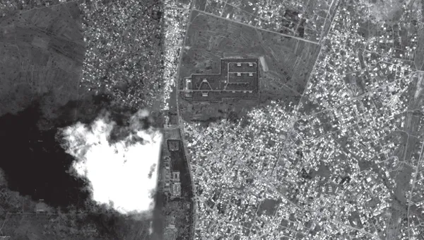
Figure 2. Lawrence Bird, Transect (2014). Video stills. Courtesy of Google Earth. © 2015 Digital Globe.
These urban discrepancies resonate with current discourse on media. As already mentioned, Easterling sees the city as an operating system that conveys information and creates a polity. And as she puts it, for the designer (or activist), ‘Exposing the workings of this operating system – in free zones, broadband technoscapes, or global standards – is as important as rehearsing the skills to hack into it’ (Easterling 2014). She expresses here one of the paradoxical vulnerabilities of infrastructural systems. The designer plays out stories that draw on the natural production of fantasy that emerges from infrastructure; she develops the multiple potentials for meaning that emerge in the gaps between parallel but distinct political and economic agendas. The cracks that emerge between these agendas are amplified by the heterogeneity of technological, and in particular digital, innovation. As Easterling puts it, ‘The...
Table of contents
- Cover Page
- Title Page
- Copyright
- Contents
- Acknowledgements
- Foreword
- Introduction
- Section One: Theories of Media, Memory and Imagination
- Section Two: Applications - Traditional Technologies of Perception and the Imagination
- Section Three: Interventions in Design and Experience – New Media and Technologies in the City
- Epilogue
- Notes on Contributors
- Index
- Back Cover