Both the Republic and Northern Ireland are part of the EU, and the peace process has bought more stability to a quiet rural area that has many scenic attractions and where political unrest has always been a localised affair. In fact, it can be hard to tell when you’ve crossed the border but slowly you’ll notice that post boxes and phone booths are no longer green but red, and prices have changed from euros to pounds...
The troublesome border
One reason it is so difficult to be sure of the border’s exact location is that it snakes its way along 18th-century county boundaries through farming land that is sometimes bleak, more often beautiful. It takes little account of natural boundaries, such as rivers, or of the cultural differences that separate Republican-minded Roman Catholics and British-oriented Protestants. A priest may find part of his parish on one side of the border, the rest on the other. Houses straddle it so that, as the joke has it, a man may sleep with his head in the United Kingdom and his heart in the Republic of Ireland.
Political expediency accounts for the absurdities. It had been intended to redraw the border rationally after partition in 1920, and a Boundary Commission was set up to advise. But in the end the British and Irish governments, hoping to avoid further trouble, suppressed the commission’s report and left things as they were. Had they decided differently, much of the subsequent conflict might have been averted.
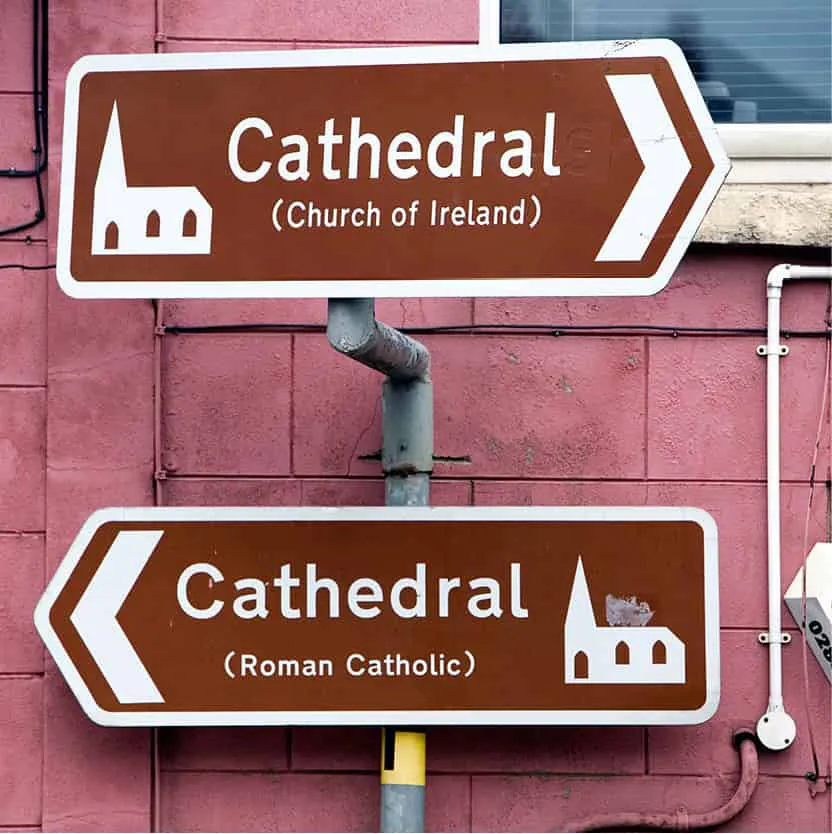
Dual signage in Armagh.
Kevin Cummins/Apa Publications
The Giant’s Causeway.
Tourism Ireland
It should be noted that the terms ‘Ulster’ and ‘Northern Ireland’ are not synonymous. Whereas the ancient Irish province of Ulster consisted of nine counties, the new state of Northern Ireland, popularly known as Ulster, consisted of only six: Antrim, Down, Armagh, Derry, Fermanagh and Tyrone. Yet the three counties that went to the Republic – Donegal, Cavan and Monaghan – are still bound to the other six by firm family and trading ties. To many locals, therefore, the border is an abstraction, or perhaps an approximation: the states it divides do not agree about its length, the Republic claiming it is 280 miles (448km) and Northern Ireland authorities adamant that it is 303 miles (485km).
Celtic, a Scottish football team, has a historic connection with the people of Ireland.
Kevin Cummins/Apa Publications
Old Derry’s walls
Across the border from Donegal, is the county of Londonderry and its famously friendly chief city, Northern Ireland’s second, whose very name has long been a bone of contention for its main two communities. Catholics refer to Derry, for both county and city, while Protestants stick to Londonderry, with officialdom increasingly resorting to the clumsy Derry-Londonderry 1 [map] in a nervous effort to maintain neutrality For its year as the inaugural UK City of Culture in 2013 adopted the slogan ‘Let’s make it LegenDerry’, but its official title was the hyphenated Derry-Londonderry. The year 2013 was also the 400th anniversary of the building of the 20-ft-tall walls that still surround the city. Derry-Londonderry has undergone considerable development since 1998, which was crowned in 2011 by the spectacular €14.5m Peace Bridge A [map] , a graceful self-anchored suspension bridge for cyclists and pedestrians. The beautiful bridge across the River Foyle has transformed Derry’s skyline, and is seen as a symbolic unification of all communities living in the city. Its citizens take a matter-of-fact approach to its troubled history, and enjoy explaining its complex loyalties to visitors.
There has been a renaissance in community activity, especially in the arts, and it has made great efforts to oblige the visitor with an annual calendar of attractions and festivals such as the massive Halloween Carnival, and the City of Derry Jazz and Big Band Festival in April/May. As with many border towns and cities in Northern Ireland, you’ll find a general acceptance of euros if you’re travelling from the Republic.
The city’s growth was financed by London guilds, which in 1613 began creating the last walled city in Europe. Its purpose was mercantile success and you can still see traces of its former economic confidence in the ornamental facades of the old shirt-making factories, which provided the city with its livelihood for generations.
The Derry City Walls B [map] (free access), 20ft (6 metres) thick and complete with watchtowers and cannon such as the 18-pounder Roaring Meg (dating from 1642), are marvellously intact.
The Bogside
Two 17th-century sieges failed to breach the walls, earning the sobriquet ‘maiden city’. Some say the city still has a siege mentality; a theory reinforced by the IRA’s daubed slogan ‘You are now entering Free Derry.’ This was the name given to the Bogside C [map] , a densely populated Roman Catholic housing estate, when its inhabitants barricaded it against the police in 1969. Their grievances were old ones. After Ireland’s partition in 1920, the city’s governing Unionists had fixed constituency boundaries to ensure a ‘permanent’ majority for themselves in what was a mainly nationalist area – an artificial majority that wasn’t overturned until the mid-1970s. Feeling isolated from the prosperous eastern counties, Derry’s citizens built up both a wonderful community spirit and a resentment that finally boiled over. A good way to experience the political history of the Bogside is to visit the The Peoples’ Gallery (46 Derry Street; mobile tel: 075 1405 2481; www.bogsideartists.com; free), in the centre of the area. Guided tours of all 12 murals by the artists who created them can be booked in advance. For more on the people’s s...