![]()
CHAPTER ONE
FARMING AND THE LANDSCAPE
The British landscape is an extraordinary creation; immensely ancient and full of enchanting surprises which open little windows of our history. I cannot believe that any other country has such a diversity of interest packed into a smaller space. It is impossible to go from one parish to another without coming across some arresting reminder of the country’s past, each with a story to tell – an Iron Age fort, a strangely corrugated field, a ruin, a folly, a venerable tree, a stone circle, castle, sunken lane, ancient bridlepath, right of way, old stone farm building or simply an isolated patch of nettles, indicating that humans had once settled in the immediate area. Every day on my farm here in a remote part of the Scottish Borders, I walk past the physical memorials to previous occupiers of this land going back dozens of centuries. On a bank above the Whitrope Water is a boggy area of ground called Buckstone Moss, named after the Buck Stone, a Neolithic megalith erected perhaps 3,500 years ago by dreamy prehistoric pastoralists. There are the visible remains of the earth banks that surrounded the little fields attached to the Iron Age fort on a hill called the Lady’s Knowe. Below these lies the Lady’s Well, a freshwater spring revered by the Celts long before the nearby chapel was dedicated to St Mary or this lovely dirge was sung about a young man murdered by the brothers of the girl he loved:
They shot him dead at the Nine-Stane Rig,
Beside the Headless Cross,
And they left him lying in his blood,
Upon the moor and moss.
They dug his grave but a barefoot deep,
By the edge of the Ninestone Burn,
And they covered him o’er with the heather forever,
The moss and the Lady fern.
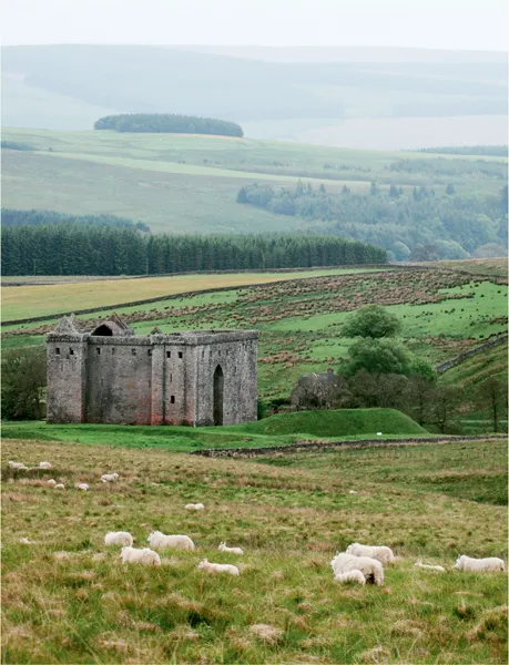
Between the Lady’s Well and the ruins of St Mary’s Chapel are a jumble of mounds and earth banks assumed to be the remains of the motte-and-bailey castle built by Sir Nicholas de Soules, Lord of Liddesdale, in 1240. Further on, beside the Hermitage Water, on a bank above a deep pool is an oblong hump, reputedly the grave of Sir Richard Knout, Sheriff of Northumberland, who was killed by retainers of the de Soules family in 1290 when they rolled him, in his armour, ‘into the frothy linn’. Then there is the grim awesome ruin of the Hermitage Castle, the ‘Gatehouse to the bloodiest valley in Britain’, where, in 1566, Mary Queen of Scots had the infamous meeting with her lover, James Hepburn, Earl of Bothwell. Back in the body of the farm, a great wall of boulders, known as the White Dyke, runs across the middle of Hermitage Hill, said to be part of the deer ‘haye’ or funnel into which deer from the castle deer park were driven and slaughtered. There are more stone walls or ‘dykes’ built in the eighteenth century during the Acts of Inclosure, when gangs of Irish labourers built mile upon mile of walling across Scotland and Northern England. At much the same time, drainers dug open drains all over the hill to improve the quality of the grazing and built ‘cundies’ (conduits) to carry water from one of the hill burns to power the water mill at the steading. An old drove road runs down the side of the farm’s northern boundary through an area known as the Mount; at the bottom are the ruins of an old toll house and the earth banks of Mount Park, where cattle from all over south-west Scotland rested for the night on their long journeys to the trysts in the north of England. The ‘old’ steading, a handsome range of slate-roofed stone buildings (cattle byres, cart sheds, granary and stabling), was built in 1835; the ‘new’ steading, a hideous open-span erection of steel girders, asbestos and concrete, was put up in the 1970s when the government was offering subsidies for new farm buildings during a drive to increase agricultural output.
I mention all this in detail because my farm only covers 600 hectares and, although having a castle on the doorstep adds a certain amount of added historical interest, the visible traces of preceding generations are similar to those of all other farms in the country.
OUR LANDSCAPE’S HERITAGE
Virtually every corner of the British Isles, from the tip of Cornwall to remotest Hebridean Island, has been owned and tilled, cropped and grazed for at least 7,000 years. For all its wonderful areas of remote, rugged and natural beauty – the Cumbrian Fells, the Cheviot Hills, the savage grandeur of the Highlands or the moorland of the West Country – Britain is the least wild of any country on the planet. It has been estimated the there is not a metre of land that has not been utilised by someone since the arrival of Neolithic man, and the landscape we love and admire is entirely man-made. The rolling heather-clad hills of Scotland are most certainly man-made – even the Broads, the stunning network of lakes and rivers covering 300 square kilometres of Norfolk and Suffolk. Until the 1960s, when the botanist and stratigrapher Dr Joyce Lambert proved otherwise, this vast wetland area was believed to be a natural formation. In fact they are the flooded excavations created by centuries of peat extraction. The Romans first exploited the rich peat beds of this flat, treeless region for fuel, and in the Middle Ages the local monasteries began to excavate the peat as a lucrative business, selling fuel to Norwich, Great Yarmouth and the surrounding area. Norwich Cathedral, one of the most stunning ecclesiastical buildings in Britain, was built with money from 320,000 tons of peat dug out of the Benedictine lands every year, until the sea levels began to rise and the pits flooded. Despite the construction of mills and dykes, the flooding continued, resulting in the unique Broads landscape of today, with its reed beds, grazing marshes and isolated clumps of wet woodland.
VIRTUALLY EVERY CORNER OF THE BRITISH ISLES, FROM THE TIP OF CORNWALL TO REMOTEST HEBRIDEAN ISLAND, HAS BEEN OWNED AND TILLED, CROPPED AND GRAZED FOR AT LEAST 7,000 YEARS. FOR ALL ITS WONDERFUL AREAS OF REMOTE, RUGGED AND NATURAL BEAUTY … BRITAIN IS THE LEAST WILD OF ANY COUNTRY ON THE PLANET.
During this incredible longevity of occupancy we have developed a passion for our countryside, a bond and an affinity with the land that is uniquely British. This love affair has been expressed throughout history by an almost obsessive desire to draw attention to the landscape by affectionately adding what was considered, at the time, to be an improvement to Nature’s already superlative offering. Britain is covered in decorated summits, follies, woodland plantings, individual trees, artificial lakes and monuments, all carefully sited to improve the vista and all constructed as a statement of gratitude.
MAKING A MARK IN THE HILLS
Our Bronze Age and Iron Age ancestors were among the most diligent of landscape enhancers, compulsively building henges, erecting megaliths and carving hill figures where the colour of the chalk or limestone substrata would show up in contrast with the green of the surrounding sward. Undoubtedly the most famous of these is the White Horse of Uffington, high on an escarpment of the Berkshire Downs below Whitehorse Hill, a mile and a half south of the village of Uffington, looking out over the Vale of the White Horse.
For a piece of artwork which optically stimulated luminescence dating has proved to be 3,000 years old, the highly stylised curving design is extraordinarily contemporary. It was either the late Bronze Age or early Iron Age occupants of the adjacent Uffington Castle hill fort who devoted the immense amount of time, organisation and effort required to carve the no-metre creature into the hillside and, despite endless hypotheses, no one really knows why. From my perspective, you only have to look at it for an explanation: the horse is a thing of beauty, young, sleek and vibrant, lunging forward with neck arched and forefeet raised, a picture of health and vitality. The carving was deliberately constructed just below the summit where it would be visible to other hill-top settlements and the horse triumphantly shouts a message from his tribe across the wooded valleys: ‘Look at me!’ The horse rejoices, ‘Am I not magnificent? See how beautiful and fertile my hill is.’
Unless the substrata was regularly kept exposed, a hill carving would disappear back into the ground within a decade and there will have been hundreds of them dotted around the uplands which are now lost to us. The two Plymouth Hoe Giants, visible until the early seventeenth century, are an example, or the Firle Corn, a nearly lost hill figure on Firle Beacon, in Sussex, now looking more like a small ear of corn or a strange weapon than a human figure, whose existence can only be seen by infrared photography. What is so remarkable about the Uffington Horse is that for over thirty centuries whenever the turf looked like growing over it the local people have always cleared it away. Long after the original architects had passed on and whatever religious, totemic or cultural significance attached to the carving had been forgotten, successive generations have preserved the carving through all vicissitudes, simply because they liked having the horse on their hill and felt it looked better with it, rather than without it.
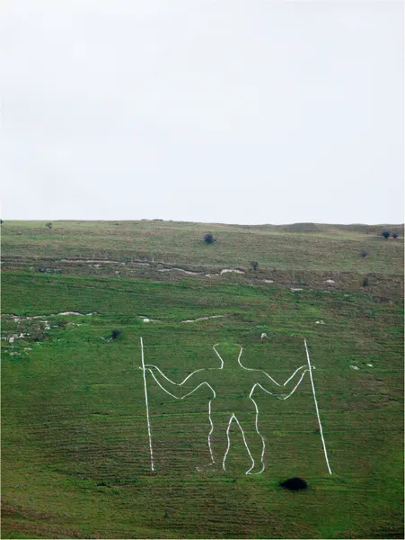
Some hill figures have been resurrected by nineteenth-and twentieth-century archaeologists – whose enthusiasm has almost certainly changed the original outlines. The Long Man of Wilmington is one, a familiar figure to me after my father moved from Cowden to Eckington Manor, in the village of Ripe, overlooking the broad sweep of the South downs in Sussex. The Long Man of Wilmington, or the Wilmington Giant, is a 70-metre-high figure holding what appear to be two staves on either side of him, cut into the downland turf on the slope of Windover Hill, between two spurs of lands that face north towards the weald. He is one of the largest such representations of a man anywhere in the world, beaten only by the Attacama Giant in Chile.
The origins of the Long Man have been the subject of endless debate, ranging from a heretical image carved by a secret occult sect of the monks of Wilmington Priory during the Middle Ages; a Celtic sun god opening the dawn portals and letting the ripening light of spring flood through, a Roman standard bearer, or a deeply symbolic prehistoric fertility symbol. Adherents to this line of thought maintain the Long Man is a reversed version of the priapic Cerne Abbas Giant and that the slope on which the old boy has been carved resembles a vulva. There is also a relatively recent theory which claims the Long Man is a sixteenth-century fake, based on carbon dating chalk rubble washed down to the foot of Windover Hill. In my view, this lacks about as much credibility as some of the more ludicrous speculation about the carving’s conception. I have no doubt that the Long Man was made by the late Bronze or early Iron Age tribesmen who occupied a substantial settlement on the summit of Windover Hill. This area is a rich source of archaeological remains, with numerous impressive high-status burial sites from different ages, lynchets or earth banks created by Celtic farming and several flint mines. Although flint was of principal importance to Neolithic people, it continued to be highly valued during successive periods of history.
THE EARLIEST-KNOWN SKETCH OF THE LONG MAN DATES FROM 1710 WHEN A SURVEYOR, JOHN ROWLEY, WAS HIRED TO MAP THE DUKE OF DEVONSHIRE’S SUSSEX ESTATES. ROWLEY’S DRAWING SHOWS THE LANKY MAN, LONE MAN OR GREEN MAN, AS HE WAS KNOWN LOCALLY THEN, AS A FAINT, FIZZY OUTLINE ON THE SWARD WITH A CONICAL HEAD AND BULGES WHERE HIS EARS SHOULD BE.
The earliest-known sketch of the Long Man dates from 1710 when a surveyor, John Rowley, was hired to map the Duke of Devonshire’s Sussex estates. Rowley’s drawing shows the Lanky Man, Lone Man or Green Man, as he was known locally then, as a faint, fizzy outline on the sward with a conical head and bulges where his ears should be. He is forward facing, with eyes, nose and mouth marked; the body is bulky and symmetrical with a posture which holds a hint of challenge or confrontation. The outline was changed and, no doubt, many of the original features lost in 1874 when the Reverend W. de St Croix of the Sussex Archaeological Society persuaded the Duke of Devonshire to fund a project to clear the turf back to the chalk and fill the trench with yellow bricks. At the time, the Duke remonstrated with de St Croix that the bricks didn’t fit the original outline and very little had been achieved of the purpose of the project. The original yellow bricks have been replaced on a number of occasions, the last time in 1969, none of which have followed the previous outlines and each has altered the Long Man’s shape slightly.
Why did the ancients carve a giant man there? I believe, as with the White Horse, they were broadcasting pride of ownership of that particular hill settlement. One thing is certain, the lovely curvature of the Downs and the uniform, slightly convex slope between the two almost identical spurs on which the Long Man has been carved would pass completely unnoticed if he wasn’t there. All the hill carvings, the few ancient ones which have survived or been resurrected and the many that were created in the nineteenth century during the great era of naturalist landscape design, draw the eye to a pleasing feature of landscape.
EARLY ‘LANDSCAPING’
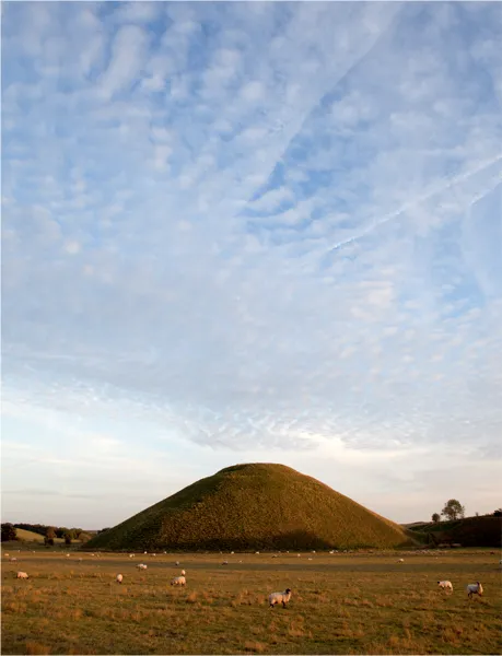
The exertion that went into digging out hill carvings pales into insignificance when compared with some of the other creations that display an extraordinary commitment of time and effort for no apparent purpose. Silbury Hill near Avesbury, in Wiltshire, is the tallest prehistoric, human-made mound in Europe and one of the largest in the world – similar in size to some of the smaller Egyptian pyramids of the Giza Necropolis. Composed mainly of chalk and clay excavated from the surrounding area, the mound stands 40 metres high and covers about two hectares. It is an exhibition of immense technical skill and prolonged control over labour and resources. Archaeologists calculate that Silbury Hill was built nearly 5,000 years ago and took 18 million man-hours, or 5,000 men working flat out for fifteen years to deposit and shape 250,000 cubic metres of material. This incredible structure contains absolutely nothing; no burial chamber of a great tribal chief and not one iota of treasure. It was a huge disappointment to the first Duke of Northumberland, who employed an army of Cornish miners to burrow their way through the hill in 1766, convinced they would find him some loot. There is no explanation why anyone should want to build Silbury Hill, apart from the indisputable fact that it looks jolly impressive in the middle of an otherwise flat piece of ground.
Equally peculiar are the inexplicable earthworks known variously as black-dykes, devil’s dykes or Grim’s dykes, found from the south of England right up into southern Scotland. These consist of a ditch and mound of varying dimensions which follow a winding course across country, often traceable for miles. The great trench and mound of the Devil’s Dyke in Cambridgeshire and the long line of Offa’s Dyke on the Welsh Marches are two of the most well known. The Devil’s Dyke runs for 12 kilometres from the flat farm...