eBook - ePub
Finding Longitude
How ships, clocks and stars helped solve the longitude problem
- English
- ePUB (mobile friendly)
- Available on iOS & Android
eBook - ePub
Finding Longitude
How ships, clocks and stars helped solve the longitude problem
Trusted by 375,005 students
Access to over 1.5 million titles for a fair monthly price.
Study more efficiently using our study tools.
Information
CHAPTER 1
THE PROBLEM
Nowe some there be that be very inquisitive to have a way to get the longitude, but that is to tedious.
William Bourne, A Regiment for the Sea (1574)1
Seafarers have always needed to know where they are to avoid danger and ensure a successful voyage. First and foremost, this was about safety, although they appreciated that more precise navigation could increase speed and efficiency. To most, this meant pinpointing the ship’s latitude and longitude on a reliable chart. Latitude was fairly straightforward to measure from a ship. Longitude was the problem and good charts could only be produced when both could be measured.
As European vessels made longer and longer voyages from the fifteenth century onwards, navigation, including the determination of longitude, began to matter more. Long-distance trade, in particular, drove the desire for speed and reliability, and with it navigational certainty, to make voyages safer and more profitable. As international trading networks developed, and with them the need for stronger navies, navigational knowledge and training became more important to those with commercial and political power. Yet, despite this growing interest, the problem of determining longitude at sea would challenge seafarers, artisans and men of science for centuries before being solved, in principle at least, in the mid-eighteenth century. In the meantime, and, indeed, for long afterwards, seafarers relied on knowledge and techniques that had been developed over generations. Many voyages were successful, some ended in disaster.
... some difference arose between them about Latitude and Longitude; Mr. Kempthorne alledging that there was no such word as Longitude; after that, further angry words arose
Evidence at the trial of John Glendon, convicted of the manslaughter of Rupert Kempthorne at the Ship Tavern in Temple Bar, London in October 16922
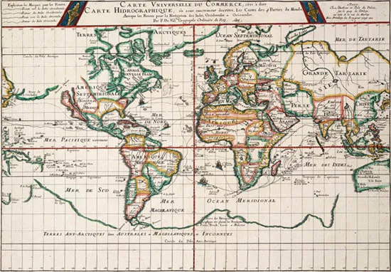
Fig. 1 Carte universelle du commerce, by Pierre Du-Val, Paris, 1686, showing French and Spanish trade routes to the West and East Indies. Note that longitudes are shown from a meridian through the Canary Islands
{National Maritime Museum, Greenwich, London}
Why longitude mattered
The importance of being able to measure longitude at sea was inextricably linked with wider issues of marine navigation and safety. For many seafarers, the main concern was not simply a matter of getting from place to place, since by the seventeenth century it was possible to sail to many parts of the world with some confidence of return. Rather, it was whether this could be done more predictably, more quickly and with less risk; in other words, could it be done more profitably?
Broadly speaking, the further people wished to sail, the greater the risks, whether along well-travelled routes with known hazards or into relatively unknown waters. The determination of longitude and other potential advances were of most interest, therefore, to nations investing in long-distance trade and outposts and settlements overseas (Fig. 2). Having opened up trade routes to the Pacific and Indian oceans, Spain and Portugal were the maritime superpowers of the sixteenth century. By the end of the seventeenth, the Netherlands, France and England were coming to dominate the oceans. It is no coincidence that the chronology of rewards for longitude solutions mirrored this sequence of maritime activity.
The expansion of global trade was linked to a progressive rise in the numbers and activities of chartered companies. Britain’s Muscovy Company (chartered in 1555), East India Company (1600), Royal Africa Company (1660) and Hudson’s Bay Company (1670) competed with similar institutions from other European countries, notably the Vereenigde Oost-Indische Compagnie or VOC (Dutch East India Company, 1602) and the Compagnie Française pour le Commerce des Indes Orientales (French East India Company, 1664). Subject to state supervision, each was granted the right to colonize, sign treaties, make and enforce laws, and hold a trade monopoly for specific territories overseas. The companies were largely free to do as they pleased but could draw on naval support and possibly, in times of crisis, government aid.

Fig. 2 – A busy Dutch East Indies factory port, possibly Surat, by Ludolf Backhuysen, 1670. Dutch and English ships can be identified by their flags, testament to the commercial interest that both countries had in Asia
{National Maritime Museum, Greenwich, London}
This was big business. In 1636–37, an inspection of the Spanish Manila galleons heading from the Spanish East Indies (Philippines) to New Spain (Mexico) valued their cargo at one million pesos (equivalent to £200,000 at the time and over £17 million today), while, in 1685, a French observer claimed that Dutch and English trade with Asia was making profits of between twelve and fifteen million livres (around £10,000,000, or more than £870 million today). This was exaggerated but English imports of tea, coffee, spices, textiles, chinaware and other commodities from Asia have been valued at just under £600,000 for that year, while the loss of five East India Company ships to privateers in 1695 cost the company £1,500,000. (Privateers were privately owned ships that had state permission to attack ships of enemy countries – and to keep the plunder.)
Privateers were just one of the risks. A ship’s high-value cargo was also in danger from natural hazards, such as storms, throughout a voyage, as were the lives of its crew. Between 1550 and 1650, one in five ships was lost between Portugal and India, and crews had a one in ten chance of dying during the voyages. It is no surprise that the safe arrival of a trading vessel at remote outposts was a cause for celebration, or that sailors looked to protective measures such as amulets to keep them from harm.
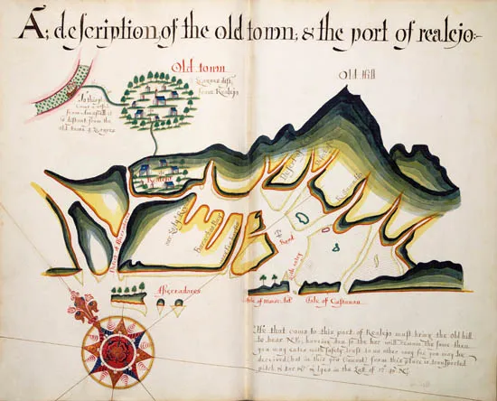
Fig. 3 – ‘A description of the old town & the port of realejo’ (El Viejo, Nicaragua), from ‘A Waggoner of the South Sea’, by William Hack, 1685, based on Spanish sea charts captured in 1680
{National Maritime Museum, Greenwich, London}
Each of the main trade routes – between Europe and America across the Atlantic; between Europe and Asia around the Cape of Good Hope; and between the Philippines and Mexico across the Pacific – presented its own challenges. Stormy passages in the Strait of Madagascar plagued Portuguese and Dutch vessels between Europe and Asia. The Dutch established an alternative route in the seventeenth century, sailing eastwards from the Cape of Good Hope until reaching the correct longitude and then turning north towards the trading posts of Indonesia. If they sailed too far east, however, they were likely to fall foul of the reefs of Australia’s western coast. It was a route on which knowing longitude really mattered.
Trading companies and the navies that supported them clearly had a vested interest in better charts and improved understanding of sea routes. As the famous diarist and naval administrator Samuel Pepys noted in 1683 in his Tangier Papers:
the East Indies masters are the most knowing men in their navigations, as being from the consideration of their rich cargoes, and the length of their sailing, more careful than others ...3
The companies encouraged their officers to gather data about weather patterns, currents, coastlines and sailing directions. It could be sensitive information. In the sixteenth century the Spanish monarchy prohibited the circulation of maps and descriptions of the Indies to protect their outposts in the Pacific. So it was a major coup when a British privateer took a book of sea charts and sailing directions from a captured Spanish ship. The charts were soon copied and made available by William Hack, a London chart maker, who presented a set to James II in 1685 (Fig. 3). By then, systematic chart provision had begun elsewhere in Europe, initially with impetus from the Dutch and French trading companies rather than their navies, while commercial chart makers like Hack led the way in England. The possibility of finding better ways to determine longitude was bound up with this interest, as the poet John Dryden suggested in his historical poem Annus Mirabilis in 1667:
What is longitude?
Latitude and longitude are the coordinates normally used to specify locations on Earth. The system was already established by the second century BC in the cartographic work of Hipparchus of Nicaea and enshrined by the second century AD in Ptolemy’s Geographia, which described the mathematical concepts of a grid for mapping the world.
Latitude is the distance north or south of the Equator, measured as an angle from the centre of the Earth, and runs from 0° at the Equator to 90° at the North and South Poles. Each degree of latitude corresponds to roughly sixty nautical miles (111 km) on the Earth’s surface. Lines of latitude run parallel to the Equator.
Longitude is the distance east or west, also measured as an angle from the Earth’s centre. Lines of longitude, called meridians, run between the poles, where they converge. So, 1° of longitude on the Earth’s surface is almost the same length as 1° of latitude at the Equator but diminishes to nothing at the poles. By convention, longitude is now measured from the Greenwich Meridian, and runs from 0° through Greenwich to 180° east and west on the other side of the globe. Until there was international agreement on this, whoever was measuring longitudes could choose any meridian or reference point they wished: Ptolemy, for example, used the island of Ferro (El Hierro) in the Canary Islands, as does the chart in Fig. 1, but London, Paris and many other places were used on different charts. Since it was difficult to measure with certainty, before the eighteenth century many charts did not show lines of longitude.
When plotting geographical positions, latitude and longitude are divided into degrees (°), minutes (') and seconds (″), with sixty minutes in a degree, and sixty seconds in a minute. The Empire State Building in New York, for example, lies at a latitude of about forty degrees, forty-four minutes and fifty-four seconds north of the Equator and at a longitude of about seventy-three degrees, fifty-nine minutes and ten seconds west of Greenwich. Its position is written as 40° 44' 54″ N, 73° 59' 10″ W.
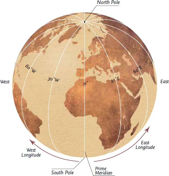
Fig. 4 – Longitude lines are imaginary lines on the Earth’s surface that run from pole to pole around the globe and give the distance east or west from the Prime Meridian
{CollinsBartholomew Ltd 2014}
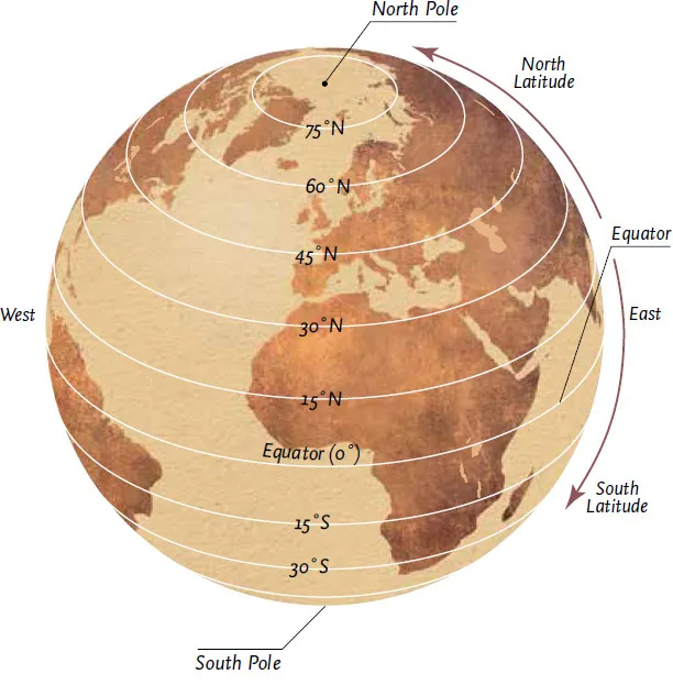
Fig. 5 – Latitude lines are imaginary lines on the Earth’s surface. They run east and west around the globe and give the distance north or south of the Equator
{CollinsBartholomew Ltd 2014}
Latitude relates to a definable reference (the Equator) and can be determined from the position of heavenly bodies such as the Sun or the Pole Star, but longitude is more difficult to determine because there are no natural references from which to measure. Since longitude is a distance in the direction of the Earth’s daily rotation, the longitude difference between two places can be thought of as being directly related to the difference between their local times as defined by the Sun’s position, local noon occurring when the Sun is highest in the sky. The Earth rotates through 360° in twenty-fo...
Table of contents
- Contents
- Forewords
- Prologue: A World Divided
- Chapter 1: The Problem
- Chapter 2: The Contenders
- Chapter 3: On Trial
- Chapter 4: Making Longitude Work
- Chapter 5: Working At Sea
- Chapter 6: Commerce And Creativity
- Chapter 7: Defining the World
- Epilogue
- References
- Bibliography
- Index
- Acknowledgements
- Copyright
- About the Publisher
Frequently asked questions
Yes, you can cancel anytime from the Subscription tab in your account settings on the Perlego website. Your subscription will stay active until the end of your current billing period. Learn how to cancel your subscription
No, books cannot be downloaded as external files, such as PDFs, for use outside of Perlego. However, you can download books within the Perlego app for offline reading on mobile or tablet. Learn how to download books offline
Perlego offers two plans: Essential and Complete
- Essential is ideal for learners and professionals who enjoy exploring a wide range of subjects. Access the Essential Library with 800,000+ trusted titles and best-sellers across business, personal growth, and the humanities. Includes unlimited reading time and Standard Read Aloud voice.
- Complete: Perfect for advanced learners and researchers needing full, unrestricted access. Unlock 1.5M+ books across hundreds of subjects, including academic and specialized titles. The Complete Plan also includes advanced features like Premium Read Aloud and Research Assistant.
We are an online textbook subscription service, where you can get access to an entire online library for less than the price of a single book per month. With over 1.5 million books across 990+ topics, we’ve got you covered! Learn about our mission
Look out for the read-aloud symbol on your next book to see if you can listen to it. The read-aloud tool reads text aloud for you, highlighting the text as it is being read. You can pause it, speed it up and slow it down. Learn more about Read Aloud
Yes! You can use the Perlego app on both iOS and Android devices to read anytime, anywhere — even offline. Perfect for commutes or when you’re on the go.
Please note we cannot support devices running on iOS 13 and Android 7 or earlier. Learn more about using the app
Please note we cannot support devices running on iOS 13 and Android 7 or earlier. Learn more about using the app
Yes, you can access Finding Longitude by Dunn, Rebekah Higgitt in PDF and/or ePUB format, as well as other popular books in History & Military & Maritime History. We have over 1.5 million books available in our catalogue for you to explore.