Implementing the ArcGIS Pro technique to design accurate, user friendly maps and making appropriate cartographic decisionsAbout This Book• Build visually stunning and useful maps; • Understand the cartographic workflows and the decisions you must take before creating the map; • Learn to create appropriate map elements and layout designs• Use the ArcGIS Online's Smart Mapping technique to create clear webmapsWho This Book Is ForIf you are a GIS analyst or a Map designer who would like to create and design a map with ArcGIS Pro then this book is for you. A basic GIS knowledge is assumed.What You Will Learn• Using ArcGIS Pro to create visually stunning maps and make confident cartographic decisions • Leverage precise layout grids that will organize and guide the placement of map elements• Make appropriate decisions about color and symbols• Critically evaluate and choose the perfect projection for your data• Create clear webmaps that focus the reader's attention using ArcGIS Online's Smart Mapping capabilitiesIn DetailArcGIS Pro is a geographic information system for working with maps and geographic information. This book will help you create visually stunning maps that increase the legibility of the stories being mapped and introduce visual and design concepts into a traditionally scientific, data-driven process. The book begins by outlining the steps of gathering data from authoritative sources and lays out the workflow of creating a great map. Once the plan is in place you will learn how to organize the Contents Pane in ArcGIS Pro and identify the steps involved in streamlining the production process. Then you will learn Cartographic Design techniques using ArcGIS Pro's feature set to organize the page structure and create a custom set of color swatches. You will be then exposed to the techniques required to ensure your data is clear and legible no matter the size or scale of your map. The later chapters will help you understand the various projection systems, trade-offs between them, and the proper applications of them to make sure your maps are accurate and visually appealing. Finally, you will be introduced to the ArcGIS Online ecosystem and how ArcGIS Pro can utilize it within the application. You will learn Smart Mapping, a new feature of ArcGIS Online that will help you to make maps that are visually stunning and useful.By the end of this book, you will feel more confident in making appropriate cartographic decisions.Style and approachThe book takes a pragmatic approach, showing various methods to create visually stunning maps.
- English
- ePUB (mobile friendly)
- Available on iOS & Android
eBook - ePub
Mapping with ArcGIS Pro
About this book
Trusted by 375,005 students
Access to over 1.5 million titles for a fair monthly price.
Study more efficiently using our study tools.
Information
Topic
InformaticaSubtopic
Modellazione e design di datiGetting Started in ArcGIS Pro
An important part of any map creation is good data organization. This begins with good file management and continues with managing layers in your workspace. As we noted in Chapter 1, How Maps Get Made, good file naming and organizational practices are critical to streamlining your mapping process. If you are working on your computer's hard drive, you may wish to set up a folder dedicated to your ArcPro projects (for example, C:\ArcProProjects). If you are working in an organizational server environment, create a folder according to your organization's file management policies.
ArcPro allows you to organize your project through the Contents pane, the Map View, and the Layout View. The Contents pane allows you to list your data layers in a variety of ways by drawing order, data source, and more. The Map View, like the Data View in ArcMap, is where you can see your data layers from a single Map Frame, geographically aligned and as they will appear in your final map. The Layout View is where you will assemble your final map output (with one or more map frames), add map elements, and finalize output for print or screen. In this chapter, we'll look at each in detail and practice organizing data for cartographic purposes.
A key feature of ArcPro is the ability to easily interface with ArcGIS Online and share data within your organization or publicly. Its new project file format also allows you to create multiple layouts with the same map frame and reuse map frames and layouts in multiple projects, which can save you time if you work with the same data regularly.
In this chapter, we will be covering the following topics:
- Opening a project
- Organizing the Contents pane
- Working in the Map View
- Transitioning to the Layout View
- Creating a map output
Opening a project
Let's open an existing project and take a look at the ArcPro interface. When you first launch the application, you'll be asked to sign in with your ArcGIS Online account (if you don't want to sign in each time, check Sign me in automatically).
If you will be working without an internet connection, you can check out a license for up to 30 days from the licensing settings.
On the opening screen, select Open another project. From the folder where you installed the sample data, select GettingStarted:

Figure 2.1: The ArcGIS Pro startup window
Once your project opens, it may look familiar to you if you use Microsoft Office. This is not accidental, but part of a collaboration between Esri and Microsoft. Across the top, you'll find the ribbon and tabs (Project, Map, Insert, Analysis, View, Edit, Imagery, and Share) in one or more panes. The panes and ribbon are context-sensitive and will change depending on what tools or features are selected. The bottom half of the window is still fairly similar to ArcMap. At the left is the Contents pane.
To the right is the Map View. (If you do not see the Contents pane, it may be turned off. To turn it on, click View|Contents). If you are familiar with ArcMap's interface and functionality, you may find the page http://pro.arcgis.com/en/pro-app/get-started/migrate-to-arcgis-pro.htm helpful:

Figure 2.2: The ArcPro work environment
Organizing the Contents pane
Within the Contents pane, the information is organized into a nested or tree structure. The top-level is the name of this particular map. Underneath it are the various layers or files that make up this map, listed in a particular order, determined by the selection chosen under the search box. Since we're viewing our layers by drawing order, these are listed in the order in which they are stacked up to make the map (we'll look at the other options later). Notice that each item has a small triangle to the left, which allows you to expand or collapse each item. Each layer can be expanded to view the symbology for that layer or collapsed to view just the layer name.
A key element of working with any mapping or design software is layer management. ArcPro lets you easily see your data layers, along with symbology and other details, in the Contents pane. The buttons underneath the Search bar change the way in which the data layers are displayed—by drawing order, file location, selectability, edit status, snapping, labeling, and chart content. Hover your mouse over each button to find out what it does. For now, make sure Drawing Order is selected:
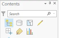
Figure 2.3: Contents pane display settings
As we can see in, Figure 2.2, the Contents pane tree begins with US Counties, the name of this map. Underneath that the data layers that compose this map are listed. In this map, there is only one data layer so far, US Counties. Underneath the layer name is a colored square representing the symbol for that layer.
In complex maps, you may want to condense the Contents pane in order to see more information. You can reveal and hide the legend information (for example, the symbol properties, such as shading for areas or the shape used for the point) for a layer by clicking on the triangle next to the layer name. Click to reveal the legend; click again to hide it.
Across the top of the window, you'll see tabs labeled US Counties and North America. US Counties and North America are map frames, which are essentially individual ma...
Table of contents
- How Maps Get Made
- Getting Started in ArcGIS Pro
- Organizing the Page Structure
- Typographic Principles
- Picking Colors with Confidence
- All Maps Are Approximations of Reality
- Understanding and Choosing Projections
- Clean Symbology and Uncluttered Maps
- Getting Started with ArcGIS Online
- Leveraging Esri Smart Mapping
- Other Books You May Enjoy
Frequently asked questions
Yes, you can cancel anytime from the Subscription tab in your account settings on the Perlego website. Your subscription will stay active until the end of your current billing period. Learn how to cancel your subscription
No, books cannot be downloaded as external files, such as PDFs, for use outside of Perlego. However, you can download books within the Perlego app for offline reading on mobile or tablet. Learn how to download books offline
Perlego offers two plans: Essential and Complete
- Essential is ideal for learners and professionals who enjoy exploring a wide range of subjects. Access the Essential Library with 800,000+ trusted titles and best-sellers across business, personal growth, and the humanities. Includes unlimited reading time and Standard Read Aloud voice.
- Complete: Perfect for advanced learners and researchers needing full, unrestricted access. Unlock 1.5M+ books across hundreds of subjects, including academic and specialized titles. The Complete Plan also includes advanced features like Premium Read Aloud and Research Assistant.
We are an online textbook subscription service, where you can get access to an entire online library for less than the price of a single book per month. With over 1.5 million books across 990+ topics, we’ve got you covered! Learn about our mission
Look out for the read-aloud symbol on your next book to see if you can listen to it. The read-aloud tool reads text aloud for you, highlighting the text as it is being read. You can pause it, speed it up and slow it down. Learn more about Read Aloud
Yes! You can use the Perlego app on both iOS and Android devices to read anytime, anywhere — even offline. Perfect for commutes or when you’re on the go.
Please note we cannot support devices running on iOS 13 and Android 7 or earlier. Learn more about using the app
Please note we cannot support devices running on iOS 13 and Android 7 or earlier. Learn more about using the app
Yes, you can access Mapping with ArcGIS Pro by Amy Rock, Ryan Malhoski in PDF and/or ePUB format, as well as other popular books in Informatica & Modellazione e design di dati. We have over 1.5 million books available in our catalogue for you to explore.