![]()
Chapter One
Pushing Back Shadows
MERCATOR WAS BORN barely twenty years after Christopher Columbus first crossed the Atlantic. Yet even though the fifteenth and sixteenth centuries are considered the great age of discoveries, an astonishing amount was known, or at least rumored, about North, South, East, and West before any of the memorable voyages of exploration ever left port.
Nearly two thousand years earlier, the Greek historian Herodotus was told of Phoenician sailors who claimed to have sailed around the southern tip of Africa.* A hundred years or so after his death, during the fourth century BC, another Greek explorer, Pytheas of Massilia, sailed into the far northern seas, to a country he called Thule, where he said the Sun went to sleep.† Still farther north, he said, land, sea, and air coalesced into a mixture on which people could neither walk nor sail. Ancient Norse sagas spoke of journeys to “a new land, extremely fertile and even having vines” that lay far to the west, beyond the setting Sun.1 Claudius Ptolemy, the Alexandrian librarian and scholar of the first century AD, had heard about the island of Taprobane, or modern Sri Lanka.2
Commercial ambition drove travelers on over new horizons. From as early as 500 BC, trading caravans from China made their way along a variety of routes through central Asia, bringing bales of fine silk to be bartered for Persian warhorses or Arabian spices, frankincense, and myrrh. Lines of heavily laden camels followed secret and well-guarded tracks through the deserts of Arabia, carrying gold, ivory, rare woods, and the spices of Yemen to the trading centers of the Mediterranean. Elsewhere, Phoenician ships journeyed beyond the Pillars of Hercules at the mouth of the Mediterranean to the very edges of the known world, bringing back tin from the Scilly Isles off the southwest coast of Britain. The prophet Ezekiel described the goods carried by the Phoenician traders, and the towns to which they traveled. “Tarshish was thy merchant, by reason of the multitude of all kind of riches, with silver, iron, tin, and lead, they traded in thy fairs. Javan, Tubal, and Meshech, they were thy merchants: they traded the persons of men and vessels of brass in thy market. They of the house of Togarmah traded in thy fairs with horses and horsemen and mules.”3
The Phoenician capital Tyre, on the coast of what is now Lebanon, had trading links that extended through the entire eastern Mediterranean and far beyond. The places Ezekiel named in these verses as the Phoenicians’ trading partners in the sixth century BC were in central Asia, southern Arabia, Armenia, and the coast of Spain, and his list of the merchandise – slaves, animals, manufactures, luxuries, and other goods – that appeared in their marketplaces lasted for more than twenty biblical verses. Travel and its commercial benefits were common enough; from the earliest times, explorers and adventurers had returned with exotic cargoes, but the stories they brought back were confused and unreliable. The island of Taprobane that Ptolemy described was said to dwarf the Indian peninsula that lay to its north, while the great medieval map of the world, dating from the late thirteenth century and still on display at Hereford in England, shows two distinct Niles, one running into the eastern Mediterranean, the other snaking across almost the whole width of the African continent. The accounts of the early adventurers were neither more nor less believable than the grotesque creatures with which ancient Greek and Roman authors loved to people the unknown places. There was no agreed view of the world; anything was possible. Travelers had no reliable or accurate way to record what they had found, to set it out for people to see. To become part of a shared image of the world, their stories had to be written down, described, and mapped.
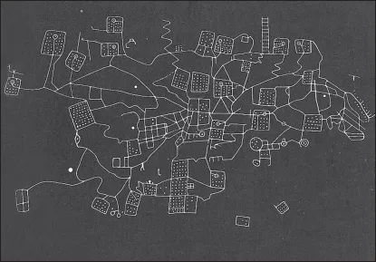
Today, the oldest so-called maps look like little more than a few carved scratches, their meaning lost with the civilizations that created them. About four thousand years ago, craftsmen near the present-day village of Bedolina, some ten thousand feet high in the Italian Alps, set about carving the rock with rough bronze or iron tools. They drew pictures of animals, daggers, and suns, much as their cavemen ancestors elsewhere in Europe had done ten thousand years earlier. But the artists of Bedolina also produced one of the first known maps. The Mappa di Bedolina is approximately four yards wide and six yards high, an ambitious patchwork of carved lines and symbols, with a series of crudely drawn rectangles, most of them filled with carefully spaced dots and linked with snaking irregular lines. They seem to represent fields with paths, rivers, or irrigation canals running between them – a graphic illustration of a cultivated landscape in the Valley of Valcamonica below. Their carvings could have had some religious or magical purpose, but after four millennia, we can only guess at what it might have been. Armed figures, huts, and shapes like ladders were added to the map hundreds of years afterward, maybe adapting it for new mystical or ceremonial rites in a mixture of religious faith and straightforward observation that was to characterize mapmaking through the ages.
The Mappa di Bedolina in Italy.
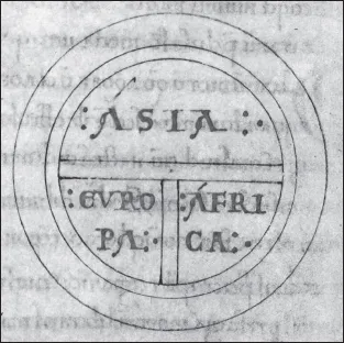
Centuries later, merchants and travelers who were pushing farther and farther afield in the search for new markets brought back garbled reports of the mighty Rivers Don and Nile running south out of Asia and north out of Africa to form a T-shape with the well-traveled waters of the Mediterranean. The waters of the ocean were then thought to surround the world in a gigantic O, leading to the creation of the so-called T-O maps, which represented for ancient Greek, Roman, and even Arab seamen an agreed image of the outline of the world.
A T-O map from Etymologiarum by Isidore of Seville
British Library, London, Rare Books and Maps Collections
THAT WAS THE WORLDVIEW Claudius Ptolemy inherited as he worked in the great library of Alexandria around the middle of the second century AD. His name appropriately linked the Greek-Egyptian Ptolemy with the Latin Claudius, for Alexandria was a cosmopolitan place, more than five hundred miles from Greece, under Roman rule, and yet at the heart of Greek civilization. The city, with its port and its great lighthouse, was a triumphal expression of Greek civilization and Roman power. Like Antwerp in Mercator’s day, it was one of the world’s great cultural and commercial crossroads, with mineral ores and spices ferried down the Nile from the depths of Africa and along an elaborate network of canals, then traded along the waterfront with the day-to-day cargoes that had been brought into harbor from the busy eastern Mediterranean. Sailors and merchants brought with them tales of distant lands like Taprobane, half-digested stories that might conceal a thin vein of truth for scholars trying to extend their grasp of the unknown world. Busy ports have always been the mines of geographers; travelers’ gossip was the unsmelted ore of exploration for Ptolemy, as it was to be for Mercator.
The merchants brought wealth to Alexandria as well. In the days of its greatness, the story went, the buildings contained so much glistening marble that a tailor could thread his needle by the reflected light of the Moon. The library where Ptolemy worked, with its collection of some seven hundred thousand manuscripts in Hebrew, Greek, and Egyptian, was one of the most obvious expressions of that wealth. Just as the merchants in the port haggled and bargained over the commerce of the mightiest empire the world had ever seen, so Alexandria’s scholars swapped ideas and theories in the library and the museum associated with it.
There are no surviving original manuscripts of Ptolemy’s work, and hardly any facts known about his life, but it would be hard to exaggerate the effect of his books on the generations that followed him. For centuries after his death, they were largely forgotten in the West, but to Mercator, the writings of Ptolemy represented the fount of ancient knowledge, the standard by which new discoveries and theories should be measured. Apart from the eight books of the Geographia, the Almagest set out Ptolemy’s views on astronomy and the place of the Earth at the center of the universe, while his various other writings encompassed mathematics, music, and history.
Other writers had concentrated on stories of the wonders that lay at the farthest reaches of knowledge, but Ptolemy’s main interest lay in establishing a reliable and coherent system for showing the spherical Earth on a flat sheet of paper. Philosophers could only suggest what form the Earth took, while travelers either by land or by sea could do little more than estimate distances – in both cases, their contributions were merely elegant guesswork. The generally accepted image of the land surrounded and limited by the ebbing and flowing waters of the sea suggested a comfortingly finite world. Ptolemy raised the possibility of a world beyond those boundaries, basing his conclusions not just on the arguments of the philosophers and on the reports of travelers but also on exact astronomical measurements.
Ptolemy saw geography as a mathematical enterprise, a matter of measurement and calculation rather than the simple telling of stories. Like Mercator some fourteen centuries after him, he designed and made instruments for measuring angles and altitudes in the heavens; his Geographia includes descriptions of a brass astrolabe and a quadrant for calculating the height of the Sun in the sky.
Ptolemy knew the true location of a place could be fixed by taking precise sightings of the stars. The Geographia therefore included a catalog of some eight thousand place-names, rivers, mountains, and peninsulas, each of them with its position defined by degrees of latitude and longitude. It is a work of staggering ambition and exactitude – the first time anyone had attempted to use coordinates in such a precise way. Many of the observations Ptolemy needed to make the calculations had already been taken, but to place cities in remote or unexplored parts of the world, he had no choice but to rely on traditional accounts and the estimates of travelers. In such a case, he said, the mapmaker should use his judgment as to what figures to use, “deciding what is credible and what is incredible.”4
It is impossible to know whether Ptolemy drew any maps to go with his Geographia. The illustrations that adorned medieval versions of his books were additions by later copyists working to his descriptions and coordinates, but in them his worldview, with the traditional three continents of Europe, Asia, and part of Africa, can clearly be recognized. Taprobane is grotesquely out of proportion in comparison with the half-formed India that lies to its north, and the coastline of the Far East is clearly drawn largely from imagination, but the Arabian peninsula and the whole of the Mediterranean basin are presented in some detail.
Perhaps most important of all, though, Ptolemy left open the possibility that there were more lands to be discovered beyond the extent of his own knowledge. Where the Romans and Greeks who came before him had been content to keep their studies inside the limits of the habitable world, his interest was in the Earth as a whole, and geography, for him, was no more or less than the art of making maps. “It is the prerogative of Geography,” he said, “to show the known habitable earth as a unit in itself, how it is situated and what is its nature; and it deals with those features likely to be mentioned in a general description of the earth, such as larger towns and great cities, the mountain ranges and the principal rivers.”5
The circle of seas that surrounded the Earth in the early T-O maps was one way of suggesting a round world, but Ptolemy’s was the first serious attempt to deal with the problem of projection. He described two possible solutions, based on a simple rectangular grid that ancient Greek philosophers had already devised, but adapting it to take account of the fact that the Earth was curved, not flat.* The systems he suggested were, as they had to be, a compromise, and one which worked satisfactorily enough within the limits of the known world. Even in the sixteenth century, most maps were still produced on grids that were simple adaptations of Ptolemy’s projections. Mercator’s greatest achievement would lie in rethinking these fifteen-hundred-year-old proposals.
Ptolemy’s geographic writings are filled with errors of fact, many of them, as he engagingly admitted himself, due to a lack of basic information. Some, such as the “great southern continent” that he believed must balance the world on its axis, would endure, like the fabulous creatures described by Herodotus and other Greek writers, for centuries after Mercator.
For all its shortcomings, though, the rediscovery and publication of the Geographia in the West laid the foundations for the work of the great cartographers of the sixteenth century. The book traveled with Columbus to the New World; when Mercator compiled his great world map of 1569, he began with Ptolemy’s calculation of the position of Alexandria. The Geographia was still being treated as the ultimate authority fourteen hundred years after its author’s death. It shows a man trying to apply scientific methods to achieve a precise, objective representation of the world in a way that was unique in his time, and remained so until Mercator’s day.
IN THE EAST, the scanty records and remains of the work of the Chinese suggest that they had their own impressive tradition. Around the third century AD, a government minister of works named Phei Hsiu set out official principles for the making of maps under the Chin Dynasty. The most important of these was that they should be constructed on a rectangular grid in order to create a consistent scale and locate places accurately. There is no evidence that Ptolemy’s thinking had reached the Far East – a grid system had been introduced in China some two hundred years before Phei Hsiu by Ptolemy’s near-contemporary Chang Heng, an astronomer royal of the Han Dynasty.* He wrote of a spherical world suspended in infinity, like a yolk in an egg, and the system he introduced of building up a map by equal squares – “casting a net over the Earth,” in a contemporary phrase – was the basis of Chinese cartography for centuries.
Chang Heng’s grid made no allowance for the curvature of the Earth, and it is hard to know from what is left of ancient Eastern cartography whether his image of a spherical world had any effect on current thought. There are no indications that early Chinese mapmakers realized the world was a sphere, that the lands they were mapping were consequently curved, nor whether the challenge, which still fascinates cartographers, of representing such a three-dimensional world on a flat surface had even occurred to them as a problem.
In the Islamic world, Arab mapmakers drew on the ideas of Ptolemy and the Greeks to develop their own traditions. By the eighth century, they were compiling maps for overland diplomatic missions to China, military campaign...