![]()
CHAPTER 1
An Introduction
It’s a warm wind, the west wind, full of birds’ cries; I never hear the west wind but tears are in my eyes.
For it comes from the west lands, the old brown hills, And April’s in the west wind, and daffodils.
John Masefield, The West Wind
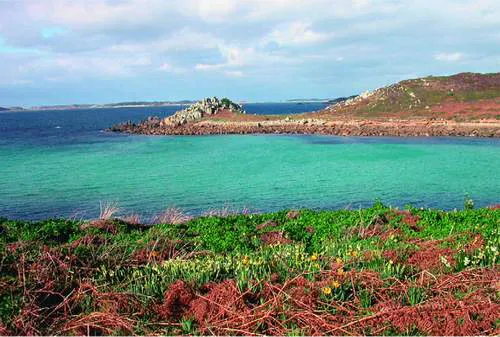
ALTHOUGH MASEFIELD probably did not have the Isles of Scilly in mind when he wrote those lines, they often remind me of the islands. In the early days of the year the low hills are brown with dead bracken stems and heather and there are daffodils and narcissus everywhere (Fig. 1). Seabirds wheel and call and often the climate is quite mild and balmy.
The rocks and islands that form the Isles of Scilly are located about 45 kilometres (28 miles) southwest of Land’s End. Mysterious, romantic and beautiful, they have long exercised the imagination of storytellers and historians, and legends abound that the Isles were once the lost islands of Lyonnesse or the undersea land of Atlantis. Or they may have been the islands known to the Greeks and Romans as the Cassiterides, the Tin islands, although there is little evidence of there having ever been any significant tin-mining on the islands.
The hills in Scilly are not high: most are under 45 metres, and the highest point is near Telegraph on St Mary’s, 49 metres above chart datum. The Isles of Scilly archipelago forms a roughly oval-shaped ring of islands in shallow seas of fewer than 13 metres in depth, except for the deep channels of St Mary’s Sound between St Agnes and St Mary’s, Smith Sound between St Agnes and Annet, and the deep waters towards the Western Rocks. Among the main group of islands are extensive sand flats the sea barely covers, with less than three
FIG 1. February on St Agnes, with daffodils flowering among the dead bracken. (Rosemary Parslow)
metres depth of water over much of the area at high tide, and with wide sand spits and shallows. At low water St Martin’s may be inaccessible by launch.
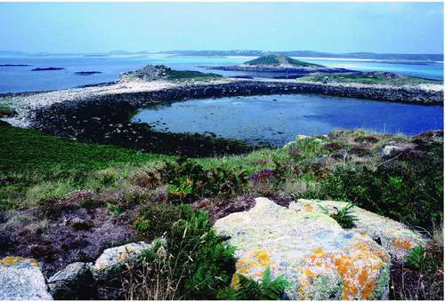
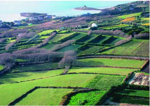
When you fly into the islands you first see the low-lying islands of the Eastern Isles looking green and brown with vegetated patches and rock (Fig. 2). Often the sand spits in the turquoise sea over the sand flats are revealed before you descend over the neat fields and cultivated land of St Mary’s to land on the airfield (Fig. 3). From the air the huge number of tiny islands and the many reefs and rocks under the water show how easily so many hundreds of ships have been wrecked in Scilly over the centuries (over 621 known wrecks have been recorded) (Larn & Larn, 1995). Even today, with depth gauges, GPS and radar, as well as more accurate charts, ships and other craft still get into trouble among the islands every year.
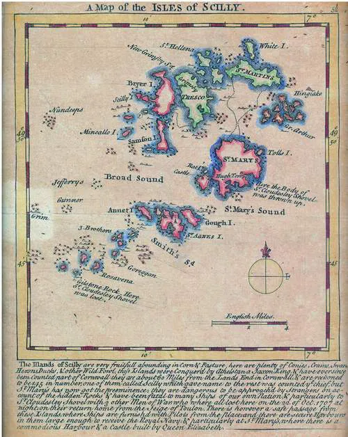
The inscription on an eighteenth-century map based on Captain Greenville Collins’ Great Britain’s Coasting Pilot survey (Fig. 4) refers to one of the most notorious Scilly shipwrecks, in addition to several other features of the islands:
The Ifands of Scilly are very fruitfull abounding in Corn & Pasture, here are plenty of Conies, Crains, Swans, Herons, Ducks, & other Wild Fowl, thefe Islands were Conquer’d by Athelstana Saxon King, & have ever since been Counted part of
FIG 2. The Eastern Isles: the view from Great Arthur towards Little Ganilly and St Martin’s. (Rosemary Parslow)
FIG 3. A patchwork of bulb fields, St Mary’s, February 2004. (Rosemary Parslow)
FIG 4. Eighteenth-century map of the Isles of Scilly, probably based on the Great Britain’s Coasting Pilot survey by Captain Greenville Collins, first published in 1693.
Cornwall: they are about 60 miles from the Lands End in Cornwall & are reckoned to be 145 in number; one of them called Scilly which gave name to the rest was counted ye chief, but St Mary’s has now got the preeminence; they are dangerous to be approach’d by strangers on account of the hidden Rocks & have been fatal to many Ships of our own Nation, & particularly to Sr. Cloudsley Shovel with 3 other Men of War who where all lost here on the 22. of Oct. 1707 at night, on their return home from the Siege of Toulon. There is however a safe passage from these Islands, where Ships are furnish’d with Pilots from the Place; and there are secure Harbours in them large enough to receive the Royal Navy: & particularly at St Mary’s, where there is a commodious Harbour & a Castle built by Queen Elizabeth.
Although there is an island called Scilly Rock off the west coast of Bryher that is reputed to have given its name to the group, this is probably not so. In the Middle Ages the name for all the islands was variously Sullia or Sullya, becoming Silli later. The current spelling as ‘Scilly’ is a more recent form to prevent confusion with the word ‘silly’ (Thomas, 1985). The islands are usually referred to as the Isles of Scilly or Scilly, never the Scilly Isles!
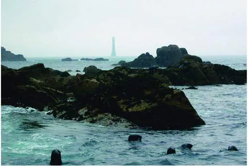
There are five islands that are now inhabited, plus some forty or so uninhabited (by people, that is – rather arrogantly we ignore the other inhabitants) and large enough to have vegetation on them, and then a further 150 or so rocks and islets. The figure cannot be definite as every stage of the tide changes one’s perspective as land is alternately exposed and hidden by the sea. From the isolated Bishop Rock with its tall lighthouse in the southwest of the group (Fig. 5) to Hanjague, east of the Eastern Isles, is 17.5 kilometres, and the archipelago
FIG 5. The Western Rocks and the Bishop Rock, the westernmost point of the Isles of Scilly, with resident grey seals. (David Mawer)
extends some 13km from north to south. The islands have a total land area of about 1,641 hectares or 16km2, more of course at low tide when more land is uncovered (Table 1). Situated on latitude 49° 56’ N and longitude 6° 18’ W, the islands are on the same latitude as Newfoundland, but the climate under the warming influence of the Gulf Stream is very different. Although the islands are part of Watsonian vice-county 1 (West Cornwall) for recording purposes, they are often treated as vice-county 1b for convenience. All the islands fall within four 10km grid squares, with most of the land being contained within just three, the fourth square being mostly water.
TABLE 1. The Isles of Scilly: areas of the principal islands. Areas are all in hectares at MHWS. (Figures from Isles of Scilly Wildlife Trust)
Isles of Scilly total area at MHWS = 1,641ha
Total area at LAT (lowest astronomical tide) = 3,065ha
Number of islands (includes rocks and stacks) of any size at MHWS = 818
Number of islands at MLWS = 3,825
Number > 0.03 ha at MHWS = 203
Number > 0.09ha (so possibly with some vegetation) = 101
CLIMATE
The climate of the Isles of Scilly is characterised as oceanic, with mild wet winters, mild sunny summers, frequent strong winds and gales, and also sea fogs. A major influence on the climate is the North Atlantic Drift, an arm of the Gulf Stream. Compared with the Cornish mainland Scilly has milder winters (February mean 7.3°C) and cooler summers. The average monthly mean temperature is 11.7°C (National Meteorological Library). With most days in the year having a temperature usually above 5°C, many plants can grow in Scilly that cannot survive on the mainland. This also includes winter annuals that grow throughout winter and flower very early in spring. As many plants on the islands are frost-sensitive the occasional bad winter can cause a considerable amount of damage. Fortunately snow and frost are much less frequent than on the adjacent mainland. Snowfalls are relatively infrequent; frosts are occasional and usually neither very hard nor long-lasting.
The rare occasions when there have been more severe frosts have had a devastating effect on the vegetation, especially the ‘exotic’ plants. Winter 1987/8 was one such occasion, with almost all the evergreen Pittosporum hedges being either killed outright or cut to the ground. Hottentot fig Carpobrotus edulis is one species that can be susceptible to both frost and salt water, but as the stands are usually dense there is nearly always a piece of the plant protected enough to survive and grow again. Rainfall is low compared with Cornwall, 825mm per year on average; some of the rain clouds appear to pass over the low islands without precipitation. The islands are prone to sea fogs and this increases the general humidity, which is reflected in the rich lichen flora – also an indicator of the clean air and lack of industrial pollutants.
As the former Duchy Land Steward wrote, ‘the weather in Scilly is characteristically unpredictable’ (Pontin, 1999). Gales and strong winds over force 8 are a frequent feature, and not just in winter: gales can happen throughout the year. Visitors can sometimes find themselves marooned on the island they are staying on for several days when the boats stop plying due to rough seas. Some of us have considered this a bonus at times!
THE SCILLONIANS
The Isles of Scilly have had almost 4,000 years of continuous occupation since the arrival of Bronze Age farmers (Thomas, 1985), but for centuries before that nomadic people who left little sign of their presence other than a few flints had visited the islands. The population has fluctuated and there have been many incomers over the centuries. Not many of the current families can trace their ancestors back more than a few hundred years, usually to the 1640s or 1650s (court records show the Trezise family was in the islands in the thirteenth century). Some are probably descendants of soldiers who came to man the Garrison and married local women. The inhabitants of St Agnes used to be known as Turks as they tended to be short and swarthy and were reputed to have had an exotic ancestry. As on other British islands such as Orkney (Berry, 1985) there has been a continuous stream of people, including Neolithic visitors, Bronze Age and Iron Age inhabitants, pirates, smugglers, Cromwellian soldiers, Royalists, French traders, British servicemen in both World Wars, land-girls, and men and women who came to staff hotels and other establishments. Many of these peoples stayed, married locals, and their descendants have added to the rich mix of heritage in the population.
Population
The resident population of the islands has stayed at around 2,000 for many years. Of these about 1,600 live on St Mary’s, with about 160 on Tresco and 100 on each of the other inhabited islands (St Martin’s, Bryher and St Agnes). During the summer holiday season visitors approximately double the population.
The Duchy of Cornwall
The Isles of Scilly became part of the original Duchy of Cornwall in 1337 when Edward, the Black Prince, became the first Duke of Cornwall. Today the islands are still owned by the Duchy, administered by a resident Land Steward. The Duchy is governed by a Council, of which His Royal Highness the Prince of Wales and Duke of Cornwall is Chairman. Much of the land on the inhabited islands is in agricultural tenancies, with the exception of the island of Tresco, which is leased to the Dorrien-Smith family, and Hugh Town, which became freehold in 1949 (Mumford, 1987). In 1999 there were some sixty farm-holdings, covering 557 hectares, of which 182 are in horticultural use, mostly bulbs. The average farm on the smaller islands of Bryher, St Agnes and St Martin’s is very small, sometimes less than 10 ha, although those on St Mary’s and Tresco are proportionately larger. Many fields are equally small, some less than 0.1ha (Pontin, 1999). Some 1,845 hectares of the unfarmed land are now leased to the Isles of Scilly Wildlife Trust, mostly heath, wetland and coast on the inhabited islands and including all the uninhabited rocks and islands.
The Council of the Isles of Scilly
The Council of the Isles of Scilly is a unitary authority (Local Government Act 1972, as applied by the Isles of Scilly Order 1978). This means the Council has unusual powers in that it has all the functions of county, district and parish councils as well as replacing the Environment Agency and the airport authorities in the islands. The islands are not automatically included in all national legislation. There are sometimes specific references or amendments to ensure that legislation also refers to the islands.
TRAVELLING TO THE ISLES OF SCILLY
These days getting to Scilly is no longer the difficult and chancy business it was in the past, and we can easily forget that for earlier visitors the journey was frequently an ordeal. Passengers could arrange to go by sailing ship to the islands, but it was not until the start of the regular mail boat after 1827 that there was an organised service from Penzance to St Mary’s. Even so the passage usually took eight to nine hours and at times as much as two days. Things picked up when a steamer service started about 1858, and a year later the railway was extended to Penzance. Then in 1937 the air service started linking Scilly with the mainland, offering an alternative and much quicker route for those reluctant to brave the sea crossing.
The RMV Scillonian (Fig. 6) is the third of that name to have carried freight and passengers between Scilly and the Cornish mainland. She sails most days (except Sunday) between spring and autumn, the crossing taking about two and a half hours according to conditions. The Scillonian is notorious for her rolling motion, which is due to her shallow dra...