Scattered through the vast expanse of stone and sand that makes up Egypt’s Western Desert are several oases. These islands of green in the midst of the Sahara owe their existence to springs and wells drawing on ancient aquifers. In antiquity, as today, they supported agricultural communities, going back to Neolithic times but expanding greatly in the millennium from the Saite pharaohs to the Roman emperors. New technologies of irrigation and transportation made the oases integral parts of an imperial economy.
Amheida, ancient Trimithis, was one of those oasis communities. Located in the western part of the Dakhla Oasis, it was an important regional center, reaching a peak in the Roman period before being abandoned. Over the past decade, excavations at this well-preserved site have revealed its urban layout and brought to light houses, streets, a bath, a school, and a church. The only standing brick pyramid of the Roman period in Egypt has been restored. Wall-paintings, temple reliefs, pottery, and texts all contribute to give a lively sense of its political, religious, economic, and cultural life. This book presents these aspects of the city’s existence and its close ties to the Nile valley, by way of long desert roads, in an accessible and richly illustrated fashion.
eBook - ePub
An Oasis City
- 256 pages
- English
- ePUB (mobile friendly)
- Available on iOS & Android
eBook - ePub
About this book
Trusted by 375,005 students
Access to over 1.5 million titles for a fair monthly price.
Study more efficiently using our study tools.
Information
Topic
HistoireSubtopic
Histoire de l'Égypte antique1
AMHEIDA IN ITS SURROUNDINGS
1.1. THE NATURAL LANDSCAPE AND ITS EVOLUTION
Paola Davoli
Lying in the western part of the Dakhla Oasis, in an oblong sandy area south of El-Qasr, Amheida is today completely surrounded by fields (Fig. 6). The oasis landscape is a patchwork formed by green land, laboriously reclaimed from the desert through irrigation, and sandy areas of various sizes, where water is not present and cultivation is thus impossible. Some of these barren areas are covered by sand dunes that encroach upon the green land, the roads, and the villages. The landscape is therefore variable according to the movements of the dunes and changes in the water supply. In this part of the Dakhla Oasis, the present pattern of the cultivated fields and the dunes clearly follows a north–south orientation, which has been produced by a stream of dunes that move down from the northern escarpment and flow toward the south at a rate of 7 m per year. So the cultivated fields are possible only between the dunes. The ancient landscape shared these characteristics, but its green areas were watered by different wells and thus located at least partly in different places (Fig. 7).
The competing forces of the accumulation of sand and of erosion from winds and water due to climatic changes have also contributed to the formation and alteration of the oasis landscape. Human activities are responsible for substantial modifications as well, especially in the last thirty years or so, with the introduction of paved roads and of drilling machines that can reach deep aquifers. Intensive-agriculture policies, population growth, and changes in the way of life have led to a great consumption of water and to the consequent formation of wastewater lakes.
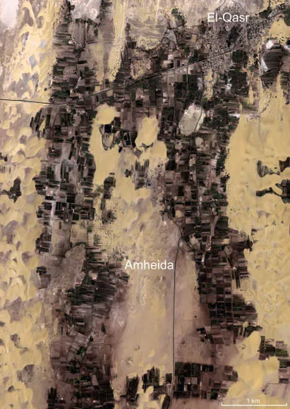
Figure 6. Satellite view of the Amheida and El-Qasr area (2000) (Base image from Ikonos).
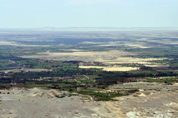
Figure 7. View of Amheida amid cultivation.
The Dakhleh Oasis Project survey identified between 1977 and 1987 about five hundred sites of various historical periods and about four hundred of prehistoric eras.1 One of the major tasks of the DOP was to study the interaction between environmental changes and human activities in the region, which involved specialists in several fields collecting data and investigating both natural and cultural evidence and features. This complex regional and diachronic study, enriched by archaeological excavations led by different teams and by new surveys, is still under way.2
Looking at the distribution of the features, settlements, and necropoleis of historical periods, we can gain some perspective on the changes in the distribution of the population, which almost certainly was determined by the availability of water. It seems evident that the extent of the ancient fields was different from that of the present green land, which is, taking into account the whole oasis, significantly greater.
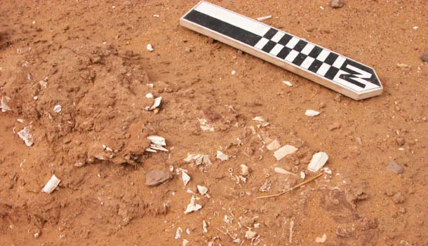
Figure 8. Burials cut by a water channel.
In this simple analysis, however, we should keep in mind that some ancient sites and features could have been invisible during the DOP survey because of the presence of the ever moving dunes or of cultivation. The regional survey should therefore, in principle, be repeated at intervals to discover new features or to confirm the collected data in areas with much wind-blown sand. The local landscape can change in just a few years, as is well demonstrated by recent villages and fields having been abandoned after the encroachment of the dunes, or by newly visible archaeological sites, as in the case of Area 11 at Amheida, which came to light only in 2013 after a dune had moved on southwards.
The study of the Amheida area landscape started in 2006 with the documentation of the then present situation: the topographic survey of the visible buildings was accompanied by a survey of the main natural features, like the dunes, spring mounds, and yardangs, of other artificial features such as channels, and of areas covered by potsherds. The denuded geological strata together with the archaeological remains suggested deep changes over time in the ancient landscape, caused by deflation. In fact, some graves were found completely exposed and intersected by later channels running southeast of the pyramid among residual mounds and along the flat plane of the south cemetery. These graves are probably to be dated to the Old Kingdom, and the skeletons deposited at the bottom of the burials are now totally exposed and badly eroded (Fig. 8).
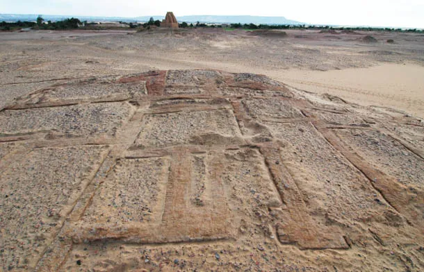
Figure 9. Preserved barrel vaults.
Harsh erosion is also evident on top of the temple hill, where it has been calculated that at least 1.5 m of stratigraphy have been lost. Erosion is also responsible for the disappearance of most of the upper parts of buildings: only a few are preserved above the present surface formed by wind-blown sand. The best-preserved buildings are those that were rapidly covered by sand; in contrast, those situated on top of natural elevations have been exposed for longer, so are eroded almost as far as floor level (like the church, B7, in Area 2.3 and the houses in Area 1). The buildings located in the lower areas were quickly invaded by clean sand up to the ceilings of the ground floors and eventually covered. This burial allowed for the preservation of ceilings, mostly barrel vaults, which are still in situ, as in the south quarters (Fig. 9). The natural erosion of whole buildings or of just their upper parts, human activity aiming to recover ancient building materials, and the accumulation of sand and dunes have produced a leveling of the city surface and a radically altered perception of its skyline and environment. The pottery sherds covering most of the site like a carpet (Fig. 10) are mostly derived from the erosion of the buildings, where sherds were employed as construction material in walls and ceilings and pots were stored on the roofs.
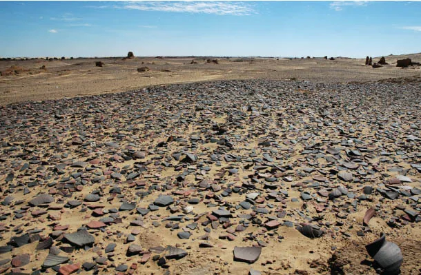
Figure 10. A sherd-covered site surface.
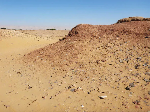
Figure 11. A Mut-formation mound of reddish shale.
Accumulation of sand and deflation are natural phenomena that occur continuously and are more severe in some periods, due to climatic changes.3 The geological and geomorphological study of the area carried out in 2010 by an international team is now focusing on residual yardangs so as to determine the major phases of erosion that occurred before the Roman period.4 In the present state of our knowledge, we can say that the settlement was built on an area periodically invaded by chains of dunes and exposed to erosion that was not uniform, as has happened in more recent times. To these phenomena we have to add dry phases in which the water table shrank, favoring rapid dune movement. The natural spring mounds needed to be reactivated several times by artificially deepening the wells, as is shown by the pottery found on and near those mounds. The west and north areas of Trimithis seem to have been sandier than the east, as is true today. Houses and living quarters moved according to the dunes, and thus the settlement was continuously having to deal with the local environment. The same would likely have happened to the farmland.
It is the combination of these phenomena that caused the disappearance of some of the oldest settlements and features—of which only scattered potsherds remain—such as possible small Old Kingdom settlements and workshops west of Amheida. On the other hand, ruins like the Old Kingdom and Second Intermediate Period buildings on the central hill were not eroded, because they had already been buried below deep strata from human occupation.
The fossilized sand dunes on which part of Trimithis is built have been reached in several trenches in Area 2.1, and this level has been explored in depth in Street 2. At this point, the trench (3 m deep) reached a geological layer rich in organics, but could not reach the Mut formation (a reddish shale) readily visible on the surface in nearby places.5 Nonetheless, a small Mut formation mound is present south of Area 1 (Fig. 11), on one side of a round depression and near a series of kilns used for pottery production. It seems possible that the shale was artificially dug out from deeper layers and used for manufacturing pottery in the fourth century CE, as the materials of the local vessels suggest.
Also, mounds of light-brown clay, employed for making mud bricks, were and still are present in the area. One such mound is preserved near the modern village of Bir Itnayn el-Arab and was used to make the mud bricks of the replica of the house of Serenos. Others can be seen in the fields between Amheida and El-Qasr. Considering the enormous quantity of mud bricks used in the city buildings and tombs, there must have been more such mounds around the settlement. Some, later covered by buildings, are in the area of the city and in the necropolis. Today the surface of those mounds is severely eroded, and very few features or buildings survive. The carpet of potsherds is the only evidence of the presence of ancient buildings there.
The empty, barren area south of the city is characterized by mounds covering tombs and by spring mounds, one of which (Fig. 12) is of impressive dimensions. Potsherds included in the mud layers of the channel coming out of it suggest a long duration for the activity of the spring, possibly aided by some artificial reactivation. Given the deflation, it is extremely difficult to say when the low, flat areas were covered by soil and cultivation. However, a pigeon house was built in the fourth century, presumably near a farmhouse, at the north border of the cemetery. A topographical and pottery survey is planned for this area in the near future.
The geological, geomorphological, and archaeological analysis of Amheida’s present state of conservation has led to the following conclusions: Roman Trimithis was constructed on an uneven area characterized by fossilized dunes, soft dunes, mounds of clay and shale, and flat, lower lands, where most of the wells for the city water supply were probably situated.6 The area was already inhabited at least from the Old Kingdom onward (§2.1), but at present it is not possible to know whether it was only one settlement, how big it was, or whether it was c...
Table of contents
- Cover
- Half title
- Title
- Copyright
- Contents
- Figures
- Contributors
- Chronological Table
- Preface
- Introduction
- 1 Amheida in Its Surroundings
- 2 Amheida before the Romans
- 3 The Urban Landscape during the Roman Period
- 4 Egyptian Religion at Trimithis during the Roman Period
- 5 Christianity at Trimithis and in the Dakhla Oasis
- 6 Economy and Society in the Roman Oasis
- 7 Trimithis in the Culture of the Eastern Roman Empire
- Abbreviations
- Bibliography
- Index
Frequently asked questions
Yes, you can cancel anytime from the Subscription tab in your account settings on the Perlego website. Your subscription will stay active until the end of your current billing period. Learn how to cancel your subscription
No, books cannot be downloaded as external files, such as PDFs, for use outside of Perlego. However, you can download books within the Perlego app for offline reading on mobile or tablet. Learn how to download books offline
We are an online textbook subscription service, where you can get access to an entire online library for less than the price of a single book per month. With over 1.5 million books across 990+ topics, we’ve got you covered! Learn about our mission
Look out for the read-aloud symbol on your next book to see if you can listen to it. The read-aloud tool reads text aloud for you, highlighting the text as it is being read. You can pause it, speed it up and slow it down. Learn more about Read Aloud
Yes! You can use the Perlego app on both iOS and Android devices to read anytime, anywhere — even offline. Perfect for commutes or when you’re on the go.
Please note we cannot support devices running on iOS 13 and Android 7 or earlier. Learn more about using the app
Please note we cannot support devices running on iOS 13 and Android 7 or earlier. Learn more about using the app
Yes, you can access An Oasis City by Roger S. Bagnall,Nicola Aravecchia,Raffaella Cribiore,Paola Davoli,Olaf E. Kaper,Susanna McFadden in PDF and/or ePUB format, as well as other popular books in Histoire & Histoire de l'Égypte antique. We have over 1.5 million books available in our catalogue for you to explore.