Take a walk on the beach with three coastal experts who reveal the secrets and the science of the North Carolina shoreline. What makes sea foam? What are those tiny sand volcanoes along the waterline? You'll find the answers to these questions and dozens more in this comprehensive field guide to the state’s beaches, which shows visitors how to decipher the mysteries of the beach and interpret clues to an ever-changing geological story.
Orrin Pilkey, Tracy Monegan Rice, and William Neal explore large-scale processes, such as the composition and interaction of wind, waves, and sand, as well as smaller features, such as bubble holes, drift lines, and black sands. In addition, coastal life forms large and small — from crabs and turtles to microscopic animals — are all discussed here. The concluding chapter contemplates the future of North Carolina beaches, considering the threats to their survival and assessing strategies for conservation. This indispensable beach book offers vacationers and naturalists a single source for learning to appreciate and preserve the natural features of a genuine state treasure.
Southern Gateways Guide is a registered trademark of the University of North Carolina Press
eBook - ePub
How to Read a North Carolina Beach
Bubble Holes, Barking Sands, and Rippled Runnels
- 180 pages
- English
- ePUB (mobile friendly)
- Available on iOS & Android
eBook - ePub
How to Read a North Carolina Beach
Bubble Holes, Barking Sands, and Rippled Runnels
About this book
Trusted by 375,005 students
Access to over 1.5 million titles for a fair monthly price.
Study more efficiently using our study tools.
Information
one
The Big Picture: Understanding Wind, Waves, and Sand
Walking on a beach in the afternoon sun, while taking in a spacious view of the sea and the mesmerizing waves or scanning the great horizon for signs of life, one often feels that time is standing still. All sense of distance and the passage of time is lost in the fascination of searching for shells or wading through the changing patterns of the swash. For the curious, observant beach stroller, the beach holds many mysteries. Beaches are nature’s palette, where colors, textures, and structures change with the variations of waves, tides, and seasons, posing myriad riddles in the sand (Plate 1).
The beach is a benchmark—a scar cut by the edge of the sea into the land. More than the strip between the low-tide line and the land beyond the tidal zone, the beach comprises the entire envelope of sand that extends offshore to depths of thirty to sixty feet, a blanket of sediment interacting with all the forces of the sea, the land, and the atmosphere.
For generations people have associated good health with taking a dip in seawater, and what fisherman doesn’t enjoy standing on a beach and challenging the sea to give up some of its bounty? North Carolina is blessed with 320 miles of ocean beaches, ranging down the edge of a long chain of beautiful barrier islands (Figs. 1.1, 1.2).
The Equilibrium That Is a Beach
The key to solving some of the riddles of a sandy beach lies in understanding its equilibrium. The shape of a beach (its width, slope, and general profile) is the end product of the sea-level change, the quality and quantity of sand, and the height of the waves and strength of the currents. This relationship often is summarized as the dynamic equilibrium of beaches. “Equilibrium” is a fancy way of saying that a balance is achieved between sea-level change, the availability of sand, the energy of waves operating on the sand, and the shape of the beach. When one changes, the others adjust accordingly (Fig. 1.3).
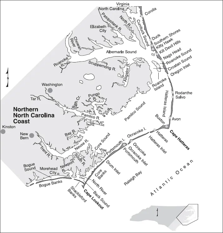
Figure 1.1. The northern North Carolina coast. (Adapted from Pilkey et al., The North Carolina Shore and Its Barrier Islands [1998])
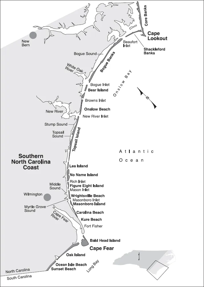
Figure 1.2.The southern North Carolina coast. (Adapted from Pilkey et al., The North Carolina Shore and Its Barrier Islands [1998])
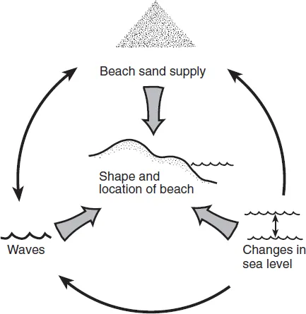
Figure 1.3.The dynamic equilibrium of beaches: When one factor changes, the others adjust accordingly. This is why beaches, if left to their own resources, are very durable. (Adapted from Pilkey et al., The North Carolina Shore and Its Barrier Islands [1998])
The constant renewal of the beach reflects the constant evolution of the sea’s equilibrium with the shore. The wind generates waves that move onshore, break, and expend energy on the beach. The global pulse of the tide raises and lowers the limit of wave influence on the beach. The earth’s rotation, tides, winds, waves, differences in water character, and changing air pressure associated with weather cells all contribute to the formation of currents that act in concert with the waves to move sand. Currents range from great ocean currents that may indirectly influence the coast, to longshore currents formed in the surf zone that cause beach sand to travel for miles, to the local rip currents that threaten swimmers. Topping all of these are the great transfers of energy during storms that whip the surface of the sea into a frenzy of waves and foam. The greatest reshaping of the shore occurs during hurricanes and nor’easters.
Big storms evoke fear in anyone who crosses their paths, but if we stay out of their way (and don’t build houses next to the beach), they are not a problem to the beach or to us. In fact, they are one of nature’s most spectacular and awesome sights (Fig. 1.4), ranking right up there with volcanoes and floods.
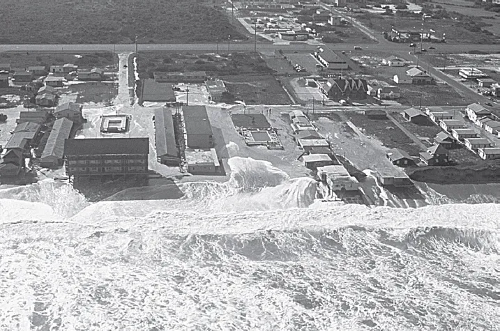
Figure 1.4. The Halloween Storm (“the Perfect Storm”) of 1991 rolling into the streets of South Nags Head. This storm remained far offshore from North Carolina, and at the time that these huge waves were coming ashore, there was only a sea breeze on the Outer Banks. (Photo by Carl Miller)
All in all, the beach is a very dynamic system that is not well understood. Just when you think you can predict natural beach behavior or design a stable artificial beach, nature always throws in a surprise. In the following sections we discuss the sea-level change, wave energy, and sand supply components of the beach dynamic equilibrium.
Sea-Level Change
Tide gauges provide the best record of sea level as it fluctuates daily, annually, and over decades and centuries. From the longest viewpoint, sea level along the North Carolina shore is rising at about one to one-and-one-half feet per century, a figure obtained by taking the average level of the sea surface each year as determined by tide gauges. This may not seem like an impressive number, but considering that the slope of North Carolina’s lower coastal plain (the mainland behind the beaches) averages a one-foot increase in elevation for every two thousand feet of horizontal distance (1:2,000), a one-foot-per-century sea-level rise becomes very significant. In theory, each foot of rise should push the regional shoreline back an average of two thousand feet (Fig. 1.5). But it’s never quite that simple.
Sea level also changes over the short term in a variety of ways. Storms blowing ashore cause the level of the sea to rise for hours at a time, or offshore winds may cause the level of the sea to temporarily drop. Seasonal wind patterns (i.e., winter/summer differences) or changes related to El Niño can cause rises or falls in sea level that last several months.
The most spectacular short-term rises in sea level occur during big storms. The high-water levels caused by a storm are called storm surges, which have been known to raise the North Carolina shoreline water levels more than twenty feet! Such a surge is the result of the combined effects of low atmospheric pressure, mounding due to the circular wind and surface currents moving about the center of the storm, and the piling up of water as it is pushed from the deep ocean into shallow nearshore waters. A storm surge carries sand (and buildings) landward as it comes ashore and sweeps them seaward on its ebb as the storm moves away and the wind reverses direction.
Daily changes in sea level are caused by the lunar tides. In North Carolina, the difference between high- and low-tide levels hovers around three feet. In other parts of the world, the tides may differ by as little as one foot or as much as forty feet. In Pamlico Sound, winds affect water level more than lunar tides.
Everybody, including the folks in states located far inland, is familiar with the terms low tide and high tide and knows that the terms refer to where the water is on the beach, either low or high. Water levels change as the result of the gravitational pull of the moon and sun on ocean waters. When the moon is located directly over an ocean, the water will mound up due to the lunar gravitational pull. On the opposite side of the planet, the ocean’s surface also will bulge as a result of the reduced lunar gravity plus the rotational force of the earth. These two bulges are the high tides, and in between, where the water is correspondingly depressed, the tides are low.
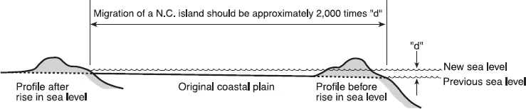
Figure 1.5. Relation between sea-level rise and the gentle slope of the coastal plain, showing why a rise of one to one-and-a-half feet per century (the rate in North Carolina) is very significant. The average slope of the lower coastal plain here is 1:2,000 (for every one foot in elevation there is a two-thousand-foot horizontal distance), which means that, in theory at least, for every one foot of sea-level rise there should be two thousand feet of shoreline retreat. (Adapted from Pilkey et al., The North Carolina Shore and Its Barrier Islands [1998]; drawing by Amber Taylor)
The moon passes any given point once every twenty-four hours and fifty minutes, which means that point will experience two high tides and two low tides each day. Because the moon’s orbit is fifty minutes longer than our twenty-four-hour day, the timing of the tides at any beach will shift by an hour or so from day to day.
The positions of the moon and sun relative to the earth change throughout the year. For this reason, the height of local tides will also change from time to time. The maximum is called spring tide, when the tidal range on a beach is the greatest. This maximum occurs when the moon is either full or new. The minimum or neap tide occurs when the moon is in its first or third quarters. The spring tide at Atlantic Beach, North Carolina, is typically six feet and the neap tide is two feet.
Depending on its orientation and position, a shoreline may experience different numbers and heights of tides. In North Carolina, the tides are semidiurnal, meaning there are two high tides of approximately the same height and two low tides of roughly the same height each day.
Ocean currents also influence sea level. Even currents that are far from the coastline, such as the Gulf Stream off North Carolina, can push water ashore and cause small changes in sea level at the shoreline that last anywhere from months to years. North Carolina is at the confluence of the Labrador Current from the north and the Gulf Stream from the south, so the effects of currents off this state are highly variable and unpredictable.
Over the last three million years, sea levels around the world have repeatedly risen and fallen by more than three hundred feet. When ice covers the extreme northern and southern portions of the continents, sea level is low, and when glaciers and ice caps melt, sea level is high. North Carolina’s coastline has extended as far out as the edge of the continental shelf during low sea levels and over seventy-five miles inland from the present coastline during periods of high sea levels. The last low sea level occurred around eighteen thousand years ago. The continental glaciers then melted, and sea level approached its present position around five thousand years ago. Throughout that period, beaches were always present along the landward retreating shoreline.
Sea level has continued to rise very slowly over the last five thousand years. In part, this is because the weight of the water on the continental shelf (formerly high and dry) is causing coastal land to sink. About one hundred years ago the rate of rise accelerated as the result of a number of coinciding events probably related to the greenhouse effect, although it is important to note that the connection between global warming and the greenhouse effect is still controversial. There is, however, no question that global warming is occurring.
Global warming is increasing the temperature of the oceans. Warmer water expands and takes up more space than cooler water, so the present rise in sea level is partially due to warmer water. Global warming also is melting mountain glaciers all over the world and adding water to the ocean through runoff. These processes lead to higher sea levels. When sea level rises, the beach must adjust by shifting landward and slightly upward.
Waves and the Currents They Form
Waves are generated at sea by the wind. Small ripples form on the water as the wind blows across the surface. The size of waves depends on three things: (1) the duration of the wind; (2) the strength of the wind; and (3) the fetch, or the distance over which the wind blows across the water. The longer the wind blows, the bigger the waves; stronger winds mean higher waves; and the greater the fetch, the bigger the waves. Thus the biggest waves of all result from the longest-lasting storms with the most energetic winds and with hundreds of miles separating the storm and the beach.
At sea a wave does not actually consist of moving water. Rather, it is formed by energy that is transferred from the wind to the water. This energy propagates, or moves, through the ocean to the beach in the form of a wave. But the water itself is not really moving forward, as in a current. Instead, the energy rolls through the water in a circular motion called a wave orbital. The crest of a wave is the top of a wave orbital, and the trough of a wave is the bottom of a wave orbital. When the wave reaches the shore, it expends its energy by breaking, which in turn moves sand and shapes the beach.
How do you measure waves? The dimensions of a wave are measured both by crest height and by the distance between crests. Wave height is the vertical distance from the crest (highest part of the wave) to the trough (lowest part of the wave). Most untrained observers at sea tend to greatly overestimate wave height, which is quite understandable because they do not have any stationary reference points. And then there is the terror factor. A person holding on for dear life in a rolling, bounding vessel is easily convinced of the gigantic size of the waves.
When you’re standing on a beach, a good way to estimate wave height is to assume that the surfer you’re watching out there is six feet tall. In many cases, the wave amplitude is also used as a measurement of the wave’s size; the wave amplitude is one-half of the wave height. The wavelength is the distance from one crest to the next crest, or from one trough to the next.
Waves travel at different speeds, typically measured as the wave period or wave frequency. Wave period is the number of seconds it takes for two successive wave crests to pass a given point. Wave frequency is the inverse of the wave period, or the number of waves that pass a given point during a given time period. As the length of a wave increases, so does its speed. In a general way, the higher the wave period, the greater the wave height. Big storms in North Carolina may produce waves with twelve- to fifteen-second periods, while calm weather wave periods are more likely to be three to five seconds.
Local storms with strong winds and small fetch create waves known as sea. Sea has an irregular, chaotic appearance characterized by steep, short waves that are unorganized and come from several directions at once. But when a storm is farther offshore, waves organize themselves into swell, a less chaotic...
Table of contents
- Cover Page
- Title Page
- Copyright Page
- Contents
- Preface
- 1: The Big Picture: Understanding Wind, Waves, and Sand
- 2: What Makes and Shapes a North Carolina Beach
- 3: North Carolina Dunes
- 4: Barrier Islands: The Platforms for Beaches
- 5: Beach Clues: Reading the Signs on the Beach
- 6: Life Signs: Beach Critters, Past and Present
- 7: Conservation of Beaches
- Beach Terminology
- Suggested Readings
- Index
Frequently asked questions
Yes, you can cancel anytime from the Subscription tab in your account settings on the Perlego website. Your subscription will stay active until the end of your current billing period. Learn how to cancel your subscription
No, books cannot be downloaded as external files, such as PDFs, for use outside of Perlego. However, you can download books within the Perlego app for offline reading on mobile or tablet. Learn how to download books offline
Perlego offers two plans: Essential and Complete
- Essential is ideal for learners and professionals who enjoy exploring a wide range of subjects. Access the Essential Library with 800,000+ trusted titles and best-sellers across business, personal growth, and the humanities. Includes unlimited reading time and Standard Read Aloud voice.
- Complete: Perfect for advanced learners and researchers needing full, unrestricted access. Unlock 1.5M+ books across hundreds of subjects, including academic and specialized titles. The Complete Plan also includes advanced features like Premium Read Aloud and Research Assistant.
We are an online textbook subscription service, where you can get access to an entire online library for less than the price of a single book per month. With over 1.5 million books across 990+ topics, we’ve got you covered! Learn about our mission
Look out for the read-aloud symbol on your next book to see if you can listen to it. The read-aloud tool reads text aloud for you, highlighting the text as it is being read. You can pause it, speed it up and slow it down. Learn more about Read Aloud
Yes! You can use the Perlego app on both iOS and Android devices to read anytime, anywhere — even offline. Perfect for commutes or when you’re on the go.
Please note we cannot support devices running on iOS 13 and Android 7 or earlier. Learn more about using the app
Please note we cannot support devices running on iOS 13 and Android 7 or earlier. Learn more about using the app
Yes, you can access How to Read a North Carolina Beach by Orrin H. Pilkey,Tracy Monegan Rice,William J. Neal in PDF and/or ePUB format, as well as other popular books in Biological Sciences & Ecology. We have over 1.5 million books available in our catalogue for you to explore.