Waves and tides, wind and storms, sea-level rise and shore erosion: these are the forces that shape our beaches, and beach lovers of all stripes can benefit from learning more about how these coastal processes work. With animation and clarity, The Beach Book tells sunbathers why beaches widen and narrow, and helps boaters and anglers understand why tidal inlets migrate. It gives home buyers insight into erosion rates and provides natural-resource managers and interested citizens with rich information on beach nourishment and coastal-zone development. And for all of us concerned about the long-term health of our beaches, it outlines the latest scientific information on sea-level rise and introduces ways to combat not only the erosion of beaches but also the decline of other coastal habitats.
The more we learn about coastline formation and maintenance, Carl Hobbs argues, the better we can appreciate and cultivate our shores. Informed by the latest research and infused with a passion for its subject, The Beach Book provides a wide-ranging introduction to the shore, and all of us who love the beach and its associated environments will find it timely and useful.

- English
- ePUB (mobile friendly)
- Available on iOS & Android
eBook - ePub
About this book
Trusted by 375,005 students
Access to over 1.5 million titles for a fair monthly price.
Study more efficiently using our study tools.
Information
Topic
Physical SciencesSubtopic
Environmental Science1
BEACHES
For many people, the beach is the shore. It is where they go to play in the sea, to sunbathe, to play beach volleyball, and to dance to beach music. In some uses, the words “shore” and “beach” are synonymous. An unemployed or a retired mariner is said to be “on the beach.” To the coastal scientist, however, a beach is a specific, physical environment. In Beaches and Coasts, Richard Davis and Duncan FitzGerald define it as a “deposit of unconsolidated sediment, ranging from boulders to sand, formed by wave and wind processes along the coast. The beach extends from the base of the dunes, cliff face, or change in physiography seaward to the low-tide line.”
Waves, currents, and wind move the sediments and shape the beach. The sediments at the beach are mobile, since they are both unconsolidated and noncohesive; that is they do not stick together. Beach sediments range in size from boulder to sand. The cohesive fine-grained sediments, silt and clay, do not play a significant role because they are unlikely to be deposited in the high-energy environment that helps create the beach. The shape of the beach is the response of the sediments to the physical forces of wind and water. The narrow, sandy strand is the buffer between the energetic sea and the relatively stable land. The beach changes form to accommodate fluctuations in the forces working on it. The shapes of the beach and the nearshore adjust during storms to dissipate energy. The coast responds to changes in the driving processes at a wide range of spatial and temporal scales. During a storm, the beach can change shape in an hour or less. It can take days or weeks for a beach to grow. The entire shore area can change over decades.
There is a full vocabulary of terms to describe different parts of the beach profile and adjacent areas (figures 1.1 and 1.2). Variations in the terminology are common; for example, the bar and trough sometimes are called the ridge and runnel, and if the bar / ridge grows vertically so that it is close to the water level, it sometimes is called a swash bar. In addition, every feature—for example, the storm or winter berm—is not always present on a beach. Conversely, a beach often has two or more ridges, each associated with a breaker zone.
The berm is the relatively flat, upper surface of the beach. It is the most hospitable place for sunbathing and playing, where beachgoers spread their blankets and play Frisbee or volleyball. The elevation of the berm is slightly above the level of high tide. The beach crest, or berm crest, is the break in slope that separates the beach face from the berm. It is the seaward edge of the berm and usually is easily discernible by eye. The beach face, or foreshore, is the surface that slopes down to the water. It is too steep for volleyball and is washed by wave run-up, so it is too wet for most sunbathers. The step, or beach step, is a usually small notch at the bottom of the beach face. It is commonly composed of coarser sediments than those that occur landward or seaward. Because the step is underwater, we seldom see it, but as we wade out into the water, our feet feel both the sudden, small drop and the pebbles. Those of us with tender feet quickly learn the location of the step and try to avoid it. As we walk farther off-shore, the slope flattens into the low-tide terrace. Often the landward face of the first ridge is quite steep.
Coastal scientists sometimes refer to differences between a winter and a summer beach, but this dual nature is not universal. Some of the earlier and better-known beach studies took place on the West Coast of North America, where the winter–summer differences are strong. Compared with the coasts of the Atlantic Ocean and Gulf of Mexico, the Pacific coast has a more distinct change from summer to winter in wave regime. Along the East and Gulf coasts, hurricanes come ashore from midsummer through late autumn, and nor’easters (northeasters) from early autumn through mid-spring, leaving generally calm conditions during late spring and early summer. There is much less seasonality to wave energy along the coasts in the eastern United States and, thus, to the shape of the beach.
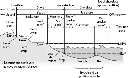
Figure 1.1 Beach terminology. (After A. Morang and L. E. Parson, Coastal terminology and geologic environments, in U.S. Army Corps of Engineers, Coastal Engineering Manual, EM 1110–2-1100, part 4, chap. 1 [2002], http://chl.erdc.usace.army.mil/CHL.aspx p=s&a=ARTICLES;104; redrawn by Network Graphics)
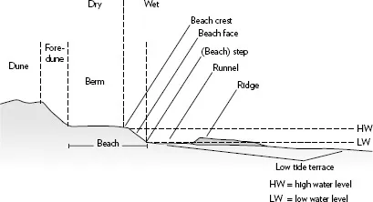
Figure 1.2 Alternative beach terminology. (Illustration redrawn by Network Graphics from an original by the author)
There are additional terms for the along-shore shape, or planform, of the beach. While it is fairly easy to define the shoreline, it is more difficult to find it. The shoreline marks where the beach and the water surface meet. As the water constantly moves up and down, whether it be rapid change due to waves and swash or slower change due to tide, the shoreline changes as we watch. The high and low waterlines are also difficult to locate with precision but are more stable than the shoreline, which is good because they frequently have very real legal implications, such as marking the seaward limit of private property. The high waterline is the intersection of the shore and the horizontal plane at the elevation of mean high water (MHW) or sometimes mean higher high water (MHHW). The low waterline is the intersection of the shore and the horizontal plane at the elevation of mean low water (MLW) or mean lower low water (MLLW). These lines are stable vertically, at least through the 19-year tidal epoch, but move laterally as the beach advances and retreats.
Beaches in specific settings may be called pocket, or headland, beaches or barrier beaches. A pocket beach occurs between two promontories or headlands. Viewed from above, pocket beaches have a crescent shape that is the result of the waves bending (refracting) around the headlands. The beach usually is an asymmetrical arc, as waves seldom approach from directly offshore. In some places, the asymmetry shifts from season to season as the regional wave-approach direction (wave climate) changes. Barrier beaches are the seaward fringe of barrier islands or (barrier) spits. An estuary or a lagoon or sound separates the mainland from the barrier, which usually is relatively straight. One end of a barrier spit is attached to the mainland, where there is a substantial supply of sand. Wave-driven currents carry sand from the source toward the end of the spit. Hence the direction in which the spit lengthens shows the dominant, or net, direction of the longshore transport of sediment. If the distance from the end of the spit to the next segment of land, or between two barrier islands, is relatively narrow, the open water is an inlet. Wide openings often are bay or river mouths.
Immediately after a hurricane or nor’easter erodes the shore, there usually is a lot of public concern about the loss of the beach. But, frequently, a couple of weeks later, the angst fades because much of the beach has returned of its own accord. This cycle of loss and recovery is similar to the seasonal cycle that creates summer and winter beaches.
Storms erode sand from the landward portions of the beach and move it both along shore and offshore. If a storm lasts through several high tides or has at least a moderate storm surge, it may erode the dune front as well. If we assume that the rate of sediment transport parallel to the shoreline is the same along any particular stretch of beach, the profile becomes lower and smoother. The berm, the visible portion of the beach, shrinks because sand is eroded and moved offshore. The sand removed from the beach is deposited in the nearshore and shallow offshore regions, so the water farther offshore becomes slightly shallower than it was before the storm. It is very difficult to survey underwater while the waves are high and breaking during the storm, so measuring and quantifying the change is hard. As the beach profile changes, waves break farther away from the shoreline and dissipate their energy across the wide nearshore zone. But the main reason that storm waves break farther from the beach is that larger waves break in deeper water. At times, the surf zone is wide enough that there are multiple lines of breakers as large, storm waves first break in relatively deep water, then re-form and break again, and, perhaps, again and again. In ever-shallower water, they finally exhaust themselves on what is left of the beach face. This long, gently sloping profile is known as a storm beach or dissipative beach (figure 1.3A), since it provides ample space for the dissipation of wave energy.
As the storm passes, the wind often shifts so that it blows offshore, the storm surge ebbs, and the waves diminish. Low, calm-weather waves create bottom currents that transport sediment across the low-tide terrace and back toward the shore. As the sediment returns shoreward, it builds a small ridge on which the waves break (figure 1.3B). The ridge and breaking waves accentuate the landward transport of sediment, since the sand cannot return seaward over the newly forming ridge. The dominantly shoreward movement molds the bar into an asymmetrical form with the steep face on the landward side. The ridge continues to migrate landward, narrowing the runnel (figure 1.3C–E), until it reaches and “welds” to the foreshore (figure 1.3F). Given the right wave conditions, the ridge can migrate up the foreshore to about the upper limit of the wave run-up. Beaches grow both vertically and horizontally through this process. More than one ridge can move across the low-tide terrace at any time.
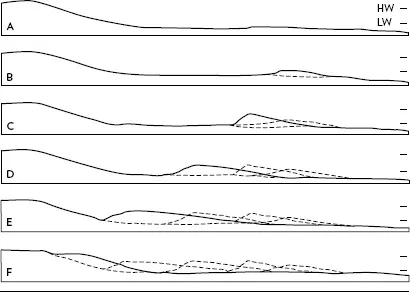
Figure 1.3 The cycle of beach growth: HW and LW are the approximate levels of mean high and mean low tide, respectively; (A) a dissipative beach shortly after a storm; (B–E) the initiation and growth of a ridge and its movement across the low tide terrace, with the parallel development of a runnel between the ridge and the beach face; (F) the welding of the ridge onto the foreshore and the resulting growth of the beach. (Illustration redrawn by Network Graphics from an original by the author)
This natural beach-nourishment process can take several days to several weeks. The maximum height of the top of the ridge above the floor of the runnel or the low-tide terrace is related to the tidal range. Frequently, the steepness and height of the landward face of the ridge can be great enough to impede wading. Several years ago at Ocean City, Maryland, I was in waist-deep water within arm’s reach of people farther offshore, but they were in water that was only ankle deep.
Knowledge of the natural process of beach growth can have practical value. When a storm removes part of the beach face and berm, the awareness that it will rebuild over a few weeks can relieve the anxiety that a property owner or resource manager may feel. Understanding how and why an offshore bar is likely to move over the course of a few days can be a matter of life and death for a Marine Corps officer planning an amphibious assault.
A strong ridge-and-runnel system, especially when the runnel is relatively narrow, leads to a complex and dynamic nearshore region. When the crest of the ridge is close to the water level, spilling or breaking waves push water into the runnel. The water has to escape; that is, it wants to return to its own level, but the ridge prohibits a direct backflow. Thus the water flows alongshore, parallel to the shoreline, in the runnel until it reaches a low area in the ridge where it is strong enough to push seaward in a narrow jet. This strong offshore flow, often concentrated in the surface water, can cut through the surf zone until it disperses in calmer water. This narrow current flowing quickly away from the beach is a rip current. Lifeguards warn swimmers that rip currents can carry them seaward and teach them to swim parallel to shore rather than fight the jet. After swimming a short distance along shore, the swimmer should be out of the rip and able to return to shore without having to swim against the current.
Rip currents can occur on beaches without ridge-and-runnel systems. Waves, especially when aided by an onshore wind, push water toward the shore, where it piles up. Eventually, the difference in elevation between the water stacked against the beach face and that farther offshore, even though small, is enough to force an outflow. This tends to be a jet-like stream of water through the surf zone—that is, a rip current.
An undertow is not a rip current, although sometimes the terms are used synonymously. Occasionally, instead of forming into discrete jets, the return current is a sheet flow. The wave backwash (-swash) down the beach face continues beneath the new up-swash, causing a two-layer flow. The upper layer is the remnant of the breaking wave moving landward, and the lower layer, the under tow, is the back-swash flowing seaward.
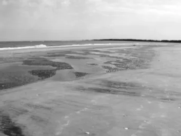
Figure 1.4 The complex set of bed forms in a runnel landward of a ridge at low tide. The sand waves formed as water trapped in the runnel by the falling tide flowed along the shore to escape. (Photograph by the author)
The rippled sand in the bottom of a runnel around the time of low ti...
Table of contents
- Cover
- Title Page
- Copyright
- Contents
- Acknowledgments
- Introduction
- 1. Beaches
- 2. Wind
- 3. Waves
- 4. Tides
- 5. Sediments
- 6. Barrier Islands and Tidal Inlets
- 7. Sand Dunes and Salt Marshes
- 8. Sea Level and Sea-Level Rise
- 9. Storms and Storm Surge
- 10. Erosion and Shore Protection
- Appendix 1. Units of Speed: Approximate Conversion Factors
- Appendix 2. Beaufort Scale
- Appendix 3. Saffir-Simpson Hurricane Scale
- Glossary
- Bibliography
- Index
Frequently asked questions
Yes, you can cancel anytime from the Subscription tab in your account settings on the Perlego website. Your subscription will stay active until the end of your current billing period. Learn how to cancel your subscription
No, books cannot be downloaded as external files, such as PDFs, for use outside of Perlego. However, you can download books within the Perlego app for offline reading on mobile or tablet. Learn how to download books offline
Perlego offers two plans: Essential and Complete
- Essential is ideal for learners and professionals who enjoy exploring a wide range of subjects. Access the Essential Library with 800,000+ trusted titles and best-sellers across business, personal growth, and the humanities. Includes unlimited reading time and Standard Read Aloud voice.
- Complete: Perfect for advanced learners and researchers needing full, unrestricted access. Unlock 1.5M+ books across hundreds of subjects, including academic and specialized titles. The Complete Plan also includes advanced features like Premium Read Aloud and Research Assistant.
We are an online textbook subscription service, where you can get access to an entire online library for less than the price of a single book per month. With over 1.5 million books across 990+ topics, we’ve got you covered! Learn about our mission
Look out for the read-aloud symbol on your next book to see if you can listen to it. The read-aloud tool reads text aloud for you, highlighting the text as it is being read. You can pause it, speed it up and slow it down. Learn more about Read Aloud
Yes! You can use the Perlego app on both iOS and Android devices to read anytime, anywhere — even offline. Perfect for commutes or when you’re on the go.
Please note we cannot support devices running on iOS 13 and Android 7 or earlier. Learn more about using the app
Please note we cannot support devices running on iOS 13 and Android 7 or earlier. Learn more about using the app
Yes, you can access The Beach Book by Carl Hobbs in PDF and/or ePUB format, as well as other popular books in Physical Sciences & Environmental Science. We have over 1.5 million books available in our catalogue for you to explore.