The 'western seaways' are an arc of sea extending from the Channel Islands in the south, through the Isles of Scilly around to Orkney in the north. This maritime zone has long been seen as a crucial corridor of interaction during later prehistory. Connections across it potentially led, for example, to the eventual arrival of the Neolithic in Britain, almost 1000 years after it arrived on the near continent. This book's primary focus is Early Neolithic settlement on islands within the 'western seaways' – sites that offer significant insight into the character of the Mesolithic–Neolithic transition in this particular maritime zone. It also explores a series of directly related, wider themes: the nature and effects of 'island-ness' in later prehistory; the visibility of material connections across the sea; the extent of Neolithic settlement variability across Britain; and the consequences of geographical biases in research for our understanding of the prehistoric past. At the heart of the book lie the results of three substantial excavations at L'Erée, Guernsey; Old Quay, St Martin's (Isles of Scilly); and An Doirlinn, South Uist. Key findings include: the first major Mesolithic flint assemblage recovered from Scilly; one of the most extensively excavated and long-lasting Neolithic/Bronze Age occupation sites in the Channel Islands; the first substantial Neolithic settlement on Scilly; and the longest sequence of Neolithic/Early Bronze Age occupation on a single site from the Outer Hebrides. In order to contextualise the significance of these findings, we also present an extended discussion and broad synthesis of Mesolithic, Neolithic and Bronze Age archaeology on each island group.
eBook - ePub
Neolithic Stepping Stones
Excavation and survey within the western seaways of Britain, 2008-2014
- 192 pages
- English
- ePUB (mobile friendly)
- Available on iOS & Android
eBook - ePub
Neolithic Stepping Stones
Excavation and survey within the western seaways of Britain, 2008-2014
About this book
Trusted by 375,005 students
Access to over 1.5 million titles for a fair monthly price.
Study more efficiently using our study tools.
Information
Subtopic
British HistoryIndex
HistoryChapter 1
Introduction
1.1. Introduction to the Stepping Stones project
This book outlines the results of three excavations conducted between 2008 and 2014 under the auspices of the Neolithic Stepping Stones project: at L’Erée, Guernsey in the Channel Islands, Old Quay, St Martin’s in the Isles of Scilly, and An Doirlinn, South Uist in the Outer Hebrides (Figure 1.01). In order to contextualise the significance of these findings, we also explore a series of wider, related themes: the character and archaeological signatures of prehistoric maritime connectivity; the nature and effects of ‘island-ness’ in later prehistory; the extent and implications of Neolithic/ Early Bronze Age (EBA) settlement variability across Britain; and the consequences of geographical biases in archaeological research in terms of our understanding of the prehistoric past.
The project’s full title was ‘Stepping stones to the Neolithic? Islands, maritime connectivity and the “western seaways” of Britain, 5000–3500 BC’. Its primary focus was the Mesolithic–Neolithic transition on the main offshore island groups within the ‘western seaways’ – an area of sea extending from the Channel Islands in the south, through the Isles of Scilly and the Isle of Man, around to the Outer Hebrides and Orkney in the north (Figure 1.01). The project represented a research collaboration between the Universities of Liverpool/Reading (Garrow) and the University of Southampton (Sturt). We also worked closely with Cardiff University, Historic Environment, Cornwall Council and three project partner museums: Guernsey Museums and Galleries, the Isles of Scilly Museum and Museum nan Eilean.
In summary, the project as a whole involved the excavation of the three sites (this volume), computer modelling of the sea around that time (Sturt et al. 2013), and the construction of a database of late Mesolithic and early Neolithic sites within the western seaways zone which led to a major radiocarbon dating programme (Garrow et al. 2017). This work was funded predominantly by a grant from the Arts and Humanities Research Council (AH/I021841/1), but money from the Society of Antiquaries of London for excavations at L’Erée (2009–11) and Old Quay (2014) was also crucial to the establishment and subsequent successful completion of the project, as was ‘pump-priming’ funding from the University of Liverpool (2008), and in-kind funding for dating from the NERC Radiocarbon Facility.
1.2. The Mesolithic–Neolithic transition in Britain, Ireland and north-west France
The processes by which Neolithic practices spread throughout Europe, and – more specifically in relation to this project – ultimately across the Channel to Britain and Ireland, have been much debated over the years (see Thomas 2013 and Anderson-Whymark & Garrow 2015 for recent reviews). In relation to the Mesolithic–Neolithic transition in Britain and Ireland, the two main issues under recent discussion have been the extent and character of migration from the continent (many incoming migrants, none, or just a few?) and the origins and directionality of change (from which parts of the near continent did Neolithic things come, and were ‘native’ British/Irish people or ‘invasive’ continental Europeans primarily responsible for their arrival?) (see for example Sheridan 2010, Whittle et al. 2011). A third, more subtle and less discussed, underlying problematic has been the character of the earliest Neolithic material culture in Britain/Ireland – whilst clearly similar to material from the continent, it is by no means typologically the same, with certain elements either ‘translated’ or missing altogether, and precise source areas difficult to pin down (Thomas 2013, 355–384). As Anderson-Whymark & Garrow (2015) stress, many of these recent discussions have been similar to culture-historical ones conducted during the middle decades of the 20th century. Our primary aim in setting up the Stepping Stones project was to understand better the timing and character of change over the 5th and 4th millennia within the crucial western seaways zone, with the intention of shedding new light on age-old problems.
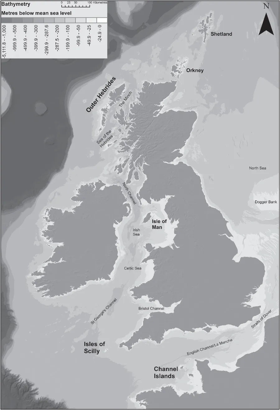
Figure 1.01. Map of the western seaways showing island groups. Topographic and bathymetric data from GEBCO14 (www.gebco.net) and EMODnet (www.emodnet-bathymetry.eu).
Given that they became islands c. 14,000 BC1 (Ireland) and c. 7000 BC (Britain) (see Sturt 2015 for details), discussions of culture-historical change associated with the start of the Neolithic must necessarily involve questions of maritime connectivity and seafaring. As we discuss in more detail in Section 1.3, the western seaways have long been seen as a crucial corridor of interaction. In recent years, Sheridan in particular has stressed connectivity along that route, identifying three main phases and routes of activity leading to the arrival and subsequent development of the Neolithic (e.g. Sheridan 2010, 91). Whittle et al., however, have argued that the dynamics of change were orientated in a quite different direction. Their radiocarbon dating-driven model suggested that ‘Neolithic things and practices’ arrived in south-east England during the 41st century cal BC, and subsequently spread north and west across Britain, and over to Ireland, in the centuries up to c. 3800–3700 cal BC (Whittle et al. 2011, 836; see also Garrow et al. 2017).
While this newly suggested directionality appears on one level to hand primacy over to the Dover–Calais route, as long as we stay interested in the long-term processes of transition, the western seaways nonetheless remain highly relevant. The best known and most convincing indication of cross-Channel contact between communities in Britain/Ireland and France during the 5th millennium is the small group of cow bones found on an artefactually Mesolithic site at Ferriter’s Cove, south-west Ireland, dated to 4495–4195 cal BC at 95% probability (Woodman & McCarthy 2003, 33). Given that there were no native wild cattle in Ireland, it has generally been assumed that these represent the (possibly partial) remains of a cow imported from France (see Thomas 2013, 266–268). Who brought them across the sea, and for what reason, it is impossible to establish. More contentious material indicators of cross-Channel contact possibly prior to the start of the Neolithic in Britain and Ireland include the Achnacreebeag pot (which bears distinct similarities to vessels from northwest France) found in an Early Neolithic tomb in western Scotland (Sheridan 2010), a small number of jadeitite axes found across Britain (which derive originally from the Alps and could potentially have been imported during the 5th millennium BC) (Sheridan 2011, 31), possible cereal pollen dating to the 5th millennium cal BC on the Isle of Man (Innes et al. 2003), and the possibly very early causewayed enclosure found at Magheraboy, Co. Sligo, dated to 4115–3850 cal BC (Whittle et al. 2011, 584) (see Anderson-Whymark & Garrow 2015 for a more detailed summary and discussion of all of this evidence). Recent findings including the much-disputed traces of wheat DNA identified in layers dating to the 6th millennium cal BC at Bouldner Cliff, Isle of Wight (Smith et al. 2015), and indeed the Belgian/French-style microliths found at Old Quay, Isles of Scilly (Chapter 3, this volume), can probably also now be added to this list. Once all of this evidence is combined, it becomes clear that, whether or not the location of the first ‘full Neolithic’ was in south-east England, the western seaways are still crucial to any understanding of maritime connections and the earliest processes of change leading up to the transition.
In light of these wider discussions of the Mesolithic– Neolithic transition in Britain and Ireland, the Channel Islands are able to play an interesting role. This island group is, of course, geographically much closer to France – in between the Normandy and Brittany peninsulas – and part of Britain only as a result of the contingencies of relatively modern politics. The transition occurs there c. 5000 BC (around a thousand years earlier than in Britain/Ireland) and Early Neolithic material culture on the islands is directly comparable to that from mainland France. Our decision to include the Channel Islands in the project was an explicit and intentional one from the outset. The subtly different issues involved in the process of transition there can play a key role in terms of providing perspective on what has at times been, ironically, a somewhat insular debate across the Channel. The particular trajectory of the Channel Islands transition is described fully in Section 1.6. The key issues pertaining to the process across the water in north-west France are, in fact, often surprisingly comparable to those under discussion in Britain and Ireland: the respective roles of incoming farmers and native hunter-gatherers, the effects and meaning of material culture potentially exchanged between these two groups, the visibility (or not) of Early Neolithic settlements (see also Marcigny et al. 2010, Scarre 2011 and Garrow & Sturt 2017).
Our main motivation for focusing attention on the island groups within the western seaways was the fact that – despite the potentially critical importance of this maritime zone – they simply had not featured enough, or even at all, in many previous accounts. While the islands within the seaways could theoretically have been crucial Earliest Neolithic ‘stepping stones’ on the way across the Channel, broader narratives had been focused almost exclusively on the mainlands either side and so it was impossible to know (see also Garrow et al. 2017). Additionally, a key legacy of the differential histories of research in different regions of Britain and Ireland (see Section 1.7) has been that on some island groups (the Channel Islands, the Isles of Scilly and the Isle of Man in particular) very little at all is known about Early Neolithic settlement (Garrow & Sturt 2011, 66–67). This situation ensured that our work within those island groups especially had the potential to enhance the archaeological record radically, simply by excavating suspected Early Neolithic sites.
One intriguing aspect of working archaeologically on islands is the enhanced visibility (and meaning) of material transformations. While marine-borne culture-historical change should not necessarily occasion more surprise than terrestrial change – in many circumstances in the past, maritime communication may well have been more common and much easier (Garrow & Sturt 2015) – the arrival of people by boat across stretches of water 40–60 km wide often does seem somehow more significant: steps across water to the stepping stones appear more significant than those taken on land up to the bank of the river. Additionally, for many of the stretches of water we are talking about here, the journey would often have been a significant event (see Section 1.3). As we discuss in more detail towards the end of this volume, islands provide a particular window onto change, focusing attention very directly on the process as well as the outcomes.
1.3. The ‘western seaways’
Given Britain and Ireland’s physical location on the western edge of the European continental shelf, surrounded by the waters of the Atlantic Ocean, English Channel, Irish, Celtic and North Seas (Figure 1.01), it is unsurprising that the role these seaways played in shaping the archaeological and historical record has been commented on for over a hundred years. As Callaghan and Scarre (2009, 358) note, the importance of the seaways first came to prominence in Fergusson’s (1872) wide ranging Rude Stone Monuments in All Countries; their Ages and Uses. Fergusson (1872, 37) used classical accounts of Caesar’s encounter with the indigenous sailing craft of the Morbihan coast to demonstrate how active these seaways were in the past, and the role they may have played in the transmission of ideas.
While Fergusson gave the sea an important role in his wide ranging antiquarian volume, it was not until the publication of Mackinder’s Britain and British Seas (1902) that we see a more considered, and potentially more influential, academic engagement. In that volume, Mackinder presented a geopolitical history within which explanations of regional differences and historical trajectories can in part be seen to reflect variable geographic and oceanographic conditions. The text is refreshing for the amount of similarity that can be found between his reading and rendering of space and more recent reconsiderations. In Mackinder’s accounts of ocean and sea variability we see glimmers of, for example, Evans’s (2003) concept of ‘texture’, that the specifics of regional environments shape the social histories that play out.
In Mackinder’s mind, Britain’s variable history could in part be seen to reflect four key divisions:
there are thus four natural parts of the sea round Britain. To the east and south are the narrow seas between the islands and the continent. To the southwest is the marine antechamber dividing into channels at the Land’s End. Spreading four square in the midst of the British Kingdoms is the inland Irish Sea; while for six hundred miles off the north-western shores is the border of the ocean (1902, 23).
Each of these seaways is seen to have a specific character, promoting different forms of interaction. From the perspective of the development of the Neolithic, Mackinder noted:
the most significant feature of British geography was not the limitless ocean, but the approach of the south-eastern corner of the islands to within sight of the continent. Kent was the window by which England looked into the great world (1902, 10).
He went on to observe that while the channel had some characteristics of being a barrier, it would also have been freely traversed throughout history. Thus in some senses, Mackinder would not have been surprised to hear the results of research by Whittle et al. (2011) into the date of the earliest Neolithic in Britain, where initial developments appear to occur along this stretch of coastline.
While, for Mackinder, Kent was the window onto the wider world, the remaining three seaways offered different qualities of connectivity and communication. The ‘marine antechamber’ of the western approaches allowed entry into the Irish Sea, a body of water that Mackinder viewed as the ‘British Mediterranean...
Table of contents
- Cover
- Title
- Copyright
- Contents
- List of figures
- List of tables
- Acknowledgements
- Chapter 1. Introduction
- Chapter 2. L’Erée, Guernsey, Channel Islands
- Chapter 3. Old Quay, St Martin’s, Isles of Scilly
- Chapter 4. An Doirlinn, South Uist, Outer Hebrides
- Chapter 5. Discussion: ‘insular connectivity’ across the western seaways
- Appendix 1. Chipped stone post-excavation analysis sampling strategies
- Bibliography
Frequently asked questions
Yes, you can cancel anytime from the Subscription tab in your account settings on the Perlego website. Your subscription will stay active until the end of your current billing period. Learn how to cancel your subscription
No, books cannot be downloaded as external files, such as PDFs, for use outside of Perlego. However, you can download books within the Perlego app for offline reading on mobile or tablet. Learn how to download books offline
Perlego offers two plans: Essential and Complete
- Essential is ideal for learners and professionals who enjoy exploring a wide range of subjects. Access the Essential Library with 800,000+ trusted titles and best-sellers across business, personal growth, and the humanities. Includes unlimited reading time and Standard Read Aloud voice.
- Complete: Perfect for advanced learners and researchers needing full, unrestricted access. Unlock 1.5M+ books across hundreds of subjects, including academic and specialized titles. The Complete Plan also includes advanced features like Premium Read Aloud and Research Assistant.
We are an online textbook subscription service, where you can get access to an entire online library for less than the price of a single book per month. With over 1.5 million books across 990+ topics, we’ve got you covered! Learn about our mission
Look out for the read-aloud symbol on your next book to see if you can listen to it. The read-aloud tool reads text aloud for you, highlighting the text as it is being read. You can pause it, speed it up and slow it down. Learn more about Read Aloud
Yes! You can use the Perlego app on both iOS and Android devices to read anytime, anywhere — even offline. Perfect for commutes or when you’re on the go.
Please note we cannot support devices running on iOS 13 and Android 7 or earlier. Learn more about using the app
Please note we cannot support devices running on iOS 13 and Android 7 or earlier. Learn more about using the app
Yes, you can access Neolithic Stepping Stones by Duncan Garrow, Fraser Sturt in PDF and/or ePUB format, as well as other popular books in History & British History. We have over 1.5 million books available in our catalogue for you to explore.