Cille Pheadair is one of more than 20 Viking Age and Late Norse settlements discovered on the island of South Uist in the Outer Hebrides (Western Isles), off the west coast of Scotland. Its unusually well-preserved stratigraphic sequence of nine phases of occupation, including five longhouses and many smaller buildings, provides a remarkable insight into daily life on a Norse farmstead during two centuries of near-continuous occupation c. AD 1000 –1200. Although the excavation at Cille Pheadair was a rescue project undertaken before the site was destroyed by coastal erosion, it provided an opportunity to address important research questions about the domestic use of space, agricultural economy, and relationships with the wider world beyond the Outer Hebrides. Careful and ground-breaking analysis of preserved house floors provided profound insights into the changing use of space within a Norse longhouse and its surrounding outbuildings. The rich assemblage of pottery, ironwork, gold and silver reveals that the inhabitants of Cille Pheadair had long-distance connections across the Viking world. A battery of scientific studies, including faunal and floral analyses, isotopic and lipid residue analyses, and soil chemistry have revealed much about the social and economic dimensions of life on a Norse farm. Detailed survey and excavation in South Uist reveals a remarkable picture of Norse-period settlement across this island which was part of the insular Viking world between Ireland and Norway, becoming part of the Kingdom of Man and later the Kingdom of the Isles. Cille Pheadair's status as an ordinary, if wealthy, farmstead can be contrasted with the much larger and longer-lived high-status settlement at Bornais to the north. The two sites together provide a fascinating insight into similarities and differences within the settlement hierarchy of the time that makes a significant contribution to our understanding of the Viking world.
eBook - ePub
Cille Pheadair
a Norse Farmstead and Pictish Burial Cairn in South Uist
- 656 pages
- English
- ePUB (mobile friendly)
- Available on iOS & Android
eBook - ePub
Cille Pheadair
a Norse Farmstead and Pictish Burial Cairn in South Uist
About this book
Trusted by 375,005 students
Access to over 1.5 million titles for a fair monthly price.
Study more efficiently using our study tools.
Information
Subtopic
British HistoryIndex
History1 Cille Pheadair and the Norse period in South Uist
M. Parker Pearson
The machair plain, a zone of shell sand, on South Uist’s west coast is known to have been densely settled in prehistory and in the historical period. Some of the first traces of this rich cultural heritage were brought to light by Tom Lethbridge in the early 1950s when he and Werner Kissling discovered numerous ancient settlement mounds on the machair of Cille Pheadair (Kilpheder) township.1 Cille Pheadair is located in the southern part of South Uist (Figure 1.1), about 6km from its south coast and 1km south of the modern community of Dalabrog (Daliburgh). The low machair plain of the southern end of the island gives way here at Cille Pheadair to a more hummocky terrain with high sandhills and dunes that characterizes the west coast from Cille Pheadair to Cill Donnain, 8km to the north (Ritchie 1967). The machair extends along most of the 33km-long west coast of South Uist and is generally about a kilometre in width east–west.
The site at Cille Pheadair is separated from the peatlands to the east by a former loch that is now dry and drained. In prehistoric times this loch was a cockle strand connected to the open sea through an inlet immediately to the south of Cille Pheadair. The machair here was thus a thin peninsula perhaps as much as 7km long, comparable to the present-day coastline of Baile Sear on the west coast of North Uist.
Although the machair in the southern part of Cille Pheadair township is largely without large hummocks or dunes, it is fronted on its west side by a long coastal dune with a steep west (seaward) face and a gentle eastern slope. The coastal dune is cut by the wind and sea into a vertically-faced sand cliff that runs north–south; a bank of storm-deposited cobbles lies at the base of the sand cliff, with a sandy beach beyond, interrupted by expanses of rock outcrops in the shallow water below the low tide line.
The Norse-period farmstead of Cille Pheadair (Site 66 in the machair survey2) was entirely buried beneath this coastal dune, covered by over 3m of windblown sand, so that no part of this deeply buried site was visible on the ground surface for probably many centuries. It had also been thus protected from burrowing by rabbits. About 70m to the south of it, not far from the former inlet to the dry loch, a Pictish burial cairn was similarly buried beneath 2m of coastal dune. After high-tide storms in the winter of 1993/1994 two brothers, Calum and Seumas MacDonald, discovered the Norse-period farmstead site, visible as a 1m-deep sandwich of grey soil and stones between thick layers of white sand, running for a length of about 40m in the sand cliff above the beach.
With a rate of erosion of this coastline estimated at about 20m–25m in 25 years, it was clear that about a metre of the western edge of the site had already been destroyed and the remainder was directly under threat from the sea. Since the provision of sea defences for this particular location, within a much longer eroding coastline, was clearly inappropriate and impractical, a rescue excavation was carried out over a total of five months during the summers of 1996, 1997 and 1998, funded jointly by Historic Scotland and the Universities of Sheffield, Cardiff and Bournemouth. The site has since been entirely destroyed (see Parker Pearson 2012c).
1.1 Previous research in Cille Pheadair township
Kissling and Lethbridge at the Kilpheder wheelhouse
Although the archaeological richness and potential of North Uist’s machair coast was demonstrated as early as the turn of the twentieth century by Erskine Beveridge (1911), in contrast South Uist’s machair was largely under-researched until the second half of the century. Even the Royal Commission’s (RCAHMS) inventory of 1928 recorded just a handful of sites in this zone, compared to the many duns, brochs, church ruins and other sites of the central peatlands and eastern hills.
One of the more remarkable stories of the Uists in the twentieth century is that of Werner Kissling, an émigré German, formerly a diplomat, who had fled Nazi Germany in the 1930s (Russell 1997). He is principally remembered for his film of everyday life on Eriskay and for his research into the ‘blackhouses’ of the Western Isles. Some ‘blackhouses’ were still being lived in when Kissling arrived in the southern isles in the 1930s, and Kissling was interested both in their stark architecture and in their use in the islanders’ economic regime of agriculture and fishing. Kissling was also interested in archaeology, having been interned during the war on the Isle of Man with Gerhard Bersu, one of the greatest German excavators of the day (Evans 1998).

Figure 1.1. Map of the Western Isles, showing the location of Cille Pheadair and other Viking Age and Late Norse sites
These interests came together when Kissling invited a Cambridge archaeologist, Tom Lethbridge, to come and join him on South Uist. They discovered a large artificial mound (c. 5m high, c. 80m east–west and c. 50m north–south) on Cille Pheadair’s machair (Site 63; Parker Pearson 1996b; 2012c). Kissling hoped to encourage the local people to take an interest in their antiquities but his hopes of excavating the buildings inside this mound were dashed when the crofter of this particular piece of land, the late Angus MacClellan, refused permission for a dig. Kissling turned his attention to a second, smaller mound (Site 64) about 400m to the southwest; this mound was known as Bruthach Sitheanach – ‘the Brae of the Fairy Hill’ (Lethbridge 1952) – though RCAHMS recorded its name as Bruthach an Tionail Ard.
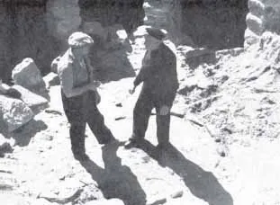
Figure 1.2. Angus John Campbell of Lochbaghasadal (left) and John Robertson of Harrapol standing within the hearth of the Kilpheder wheelhouse (from Lethbridge 1954: pl. 2 [a])
During the dry spring of 1951 Kissling and Lethbridge noticed that outlines of circular walls could be detected as parchmarks in the grass over this mound. This was one of three circular buildings that Lethbridge identified from parchmarks, confirmed by geophysical earth resistance survey of the mound in 1998 (Parker Pearson 2012c: 50). That summer, which was remembered as being exceptionally hot and dry, Kissling and Lethbridge employed a team of local men, supervised by John Robertson of Harrapol (Skye), to shovel out the deep infill of windblown sand (Figure 1.2). Kissling had extraordinary beginner’s luck because the stone walls and piers of the Iron Age ‘wheelhouse’ that he and Lethbridge discovered inside the mound were entirely intact to the base of the roof, almost 2.5m (8ft) above the floor (Figure 1.3). In no excavation before or since in the Western Isles have archaeologists found buried remains of prehistoric houses so completely preserved.
A Roman brooch found on the ledge of one of the house’s wall chambers indicated that the house might have been abandoned around AD 100–150. The excavation also recovered pottery sherds, bone tools and an iron pin fragment from inside the house (Lethbridge 1952). In their styles these artefacts are of types now dated to the Middle Iron Age, between c. 200 BC and c. AD 400 (Armit 1996: 145–8; Parker Pearson and Sharples 1999: 359; Sharples 2012a: 17).
The following summer, limited excavations continued immediately outside the south side of the wheelhouse to reveal a smaller round building that was joined to the wheelhouse by an underground passage. When the excavation ended the interior void of this round outbuilding was filled in but, unfortunately, the wheelhouse was not. This magnificent roundhouse should have been either reburied or consolidated by shoring and pointing; in the last 60 years, its walls and internal stone piers have largely collapsed and the visitor is presented today with a large hole filled with fallen stones. Local opinion today is that the Kilpheder wheelhouse should be consolidated for better public access and understanding.
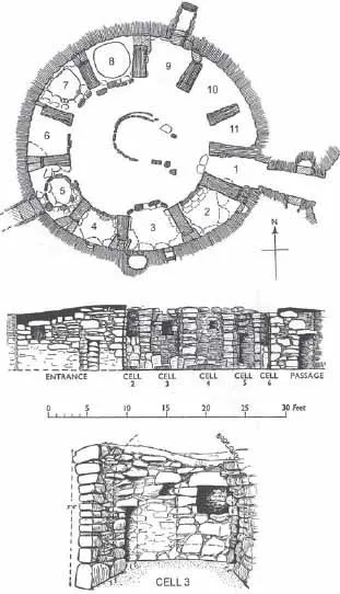
Figure 1.3. Plan and elevation of the Kilpheder wheelhouse (from Lethbridge 1952)
The 1951 excavation is still remembered by local residents now approaching old age; Kissling himself was evidently a dynamic personality since there are still local memories both of his supervision of the workmen and of the swimming lessons and races he organized for the local children. Tom Lethbridge published the results of the 1951 season in the Proceedings of the Prehistoric Society in the following year but, curiously, by the 1990s nobody remembered his presence on the excavations.3
The reason why the Kilpheder wheelhouse – and presumably its neighbours within the mound – is so well preserved is worth considering. Every other prehistoric or later house that has been excavated on the machair has been robbed of its stones, mostly in the years immediately after abandonment. In some cases, that robbing is intermittent and partial and in others it is near-total. The reason, no doubt, is that building stone for any structure had to be brought onto the machair, either from the beach or from the hills some four to ten kilometres to the east. The Kilpheder wheelhouse’s fabric consisted of large and partially shaped stones from the hills. This was masonry that would have been highly sought after for building and yet this structure was left intact.
We might speculate, then, that the three houses within this mound were dramatically engulfed by windblown sand and deeply buried before anyone had a chance to remove their stonework. Yet even this scenario seems unlikely, given that Lethbridge records how clean the wheelhouse floor was. He wrote that even the hearth had been swept clean before the house was abandoned (Lethbridge 1952: 180). He later speculated that the clean hearth and floor, together with various artefacts left in wall niches and on the floors of the cells between the piers (an antler pick, a piece of pumice, an awl, a quartzite strike-a-light and a horn ferrule as well as the brooch) indicated that the inhabitants had gone away and never returned (1954: 68–9). Our excavations of other house floors of similar date at Dun Vulan (Parker Pearson and Sharples 1999), Bornais (Sharples 2005d; 2012b), Cill Donnain (Zvelebil 1991; Parker Pearson and Zvelebil 2014) and Cladh Hallan (Parker Pearson et al. 2004a: 59–87; in prep.) – where the floors and hearths were anything but swept and clean – reveal that Lethbridge’s diagnosis was indeed correct. So how do we explain why the buildings were left untouched?
The Kilpheder wheelhouse appears unusual in that it had its floor and hearth swept and its roof removed before abandonment, being then left untouched until it had been entirely covered with sand. The Roman brooch left on one of the ledges is also unusual because it is one of the very few Roman manufactured goods imported into western Scotland at that time (Armit 1996: 160–1; see Sharples 2012b: 19, 339). At some time in the second century AD, this house – and probably the entire group of wheelhouses in the mound – was abandoned and left untouched. We may speculate about the possible reasons why. Was it a plague house, abandoned after catastrophic illness and death, like one of the nineteenth-century blackhouses at Balnabodach on Barra (Branigan 2005)? Was it a house that had been associated with some unsupportable event or action, such as witchcraft? Perhaps a violent act occurred there or a tragic death such as drowning overtook its inhabitants. Or were the inhabitants driven out because of the loss of their livelihood or through forced relocation?
The mound into which Kissling and Lethbridge were not permitted to dig (Site 63) dates broadly to the same period of the Middle Iron Age as the Kilpheder wheelhouse, on the basis of pottery found during surface survey, although some sherds recovered from Site 63 are of a type found on the floor of the wall chamber at Dun Vulan and dated to between the first century BC and the second century AD (Parker Pearson and Sharples 1999: 92, fig. 4.13.1, 9 and 10), making this mound perhaps slightly earlier than the Kilpheder wheelhouse. Paradoxically (and luckily for Kissling and Lethbridge), it seems from the results of our geophysical survey (Parker Pearson 2012c) that the mound of Site 63 contains no similarly complete buildings.
The long-term settlement sequence at Cille Pheadair before the Viking Age
Lethbridge considered that Kilpheder was just one of nine Middle Iron Age wheelhouses within this particular part of South Uist on Cille Pheadair and Dalabrog machair (1952: 177). Unfortunately his map is at too small a scale and his dots too large for these proposed sites to be relocated precisely. He does, however, provide locations for five of them in the text (ibid.: 176). From his descriptions, four of these mounds date to the Middle Iron Age but he seems to have found no dating evidence for the other five. From our own survey and those of others we can now identify a total of 27 prehistoric settlement mounds in this area – 18 on Dalabrog’s machair and nine on Cille Pheadair’s machair (Figure 1.4; see Parker Pearson 1996b; 2012c).
Although most of the machair is covered by grass, ancient settlement mounds can be identified in unploughed areas by the presence of marine shell (usually limpets and winkles, but also cockles, mussels, etc.), animal bone and sherds in the spoil produced by rabbit burrows and in scoured and eroded areas. Those settlement mounds currently being ploughed also produce similar materi...
Table of contents
- Cover
- Title
- Copyright
- Contents
- List of Figures
- List of Tables
- List of Contributors
- Acknowledgements
- 1. Cille Pheadair and the Norse period in South Uist: M. Parker Pearson
- 2. The Pictish burial cairn, cal AD 640–780: M. Parker Pearson
- 3. Initial construction and occupation (phase 1), starting cal AD 945–1020: M. Parker Pearson and M. Brennand
- 4. The earliest deposits above the pits (phase 2), starting cal AD 945–1020: M. Parker Pearson and M. Brennand
- 5. The first stone longhouse: House 700 (phase 3), constructed cal AD 1030–1095: M. Parker Pearson and M. Brennand
- 6. The second stone longhouse: House 500 (phase 4), constructed cal AD 1060–1110: M. Parker Pearson and M. Brennand
- 7. Modification of House 500 (phase 5), rebuilt cal AD 1070–1125: M. Parker Pearson and M. Brennand
- 8. The sheds (phase 6), constructed cal AD 1100–1155: M. Parker Pearson and M. Brennand
- 9. The east–west longhouse: House 312 (phase 7), constructed cal AD 1105–1160: M. Parker Pearson and M. Brennand
- 10. The last longhouse: House 007 (phase 8), constructed cal AD 1140–1205: M. Parker Pearson and M. Brennand
- 11. Reuse and abandonment of the ruins of House 007 (phase 9), ending cal AD 1160–1245: M. Parker Pearson and M. Brennand
- 12. The ceramics
- 13. The combs, ornaments, weights and coins: C. Paterson with contributions by M. Parker Pearson and E. Besly
- 14. The bone and antler tools: C. Paterson
- 15. The iron knives, tools and weapons: M. Parker Pearson
- 16. The stone artefacts: M. Parker Pearson with contributions by G.D. Gaunt, C. Paterson, M. Edmonds and K. Martin
- 17. Industrial activity
- 18. The faunal remains – mammals
- 19. The faunal remains – birds, fish and marine molluscs
- 20. The human remains: A. Chamberlain
- 21. The carbonized plant remains and wood charcoal
- 22. Absorbed and visible organic residues: L. Cramp and R.P. Evershed
- 23. Soil micromorphology: C. Ellis
- 24. Radiocarbon dating: P. Marshall, M. Parker Pearson and G. Cook
- 25. The Cille Pheadair farmstead in its context
- Bibliography
Frequently asked questions
Yes, you can cancel anytime from the Subscription tab in your account settings on the Perlego website. Your subscription will stay active until the end of your current billing period. Learn how to cancel your subscription
No, books cannot be downloaded as external files, such as PDFs, for use outside of Perlego. However, you can download books within the Perlego app for offline reading on mobile or tablet. Learn how to download books offline
Perlego offers two plans: Essential and Complete
- Essential is ideal for learners and professionals who enjoy exploring a wide range of subjects. Access the Essential Library with 800,000+ trusted titles and best-sellers across business, personal growth, and the humanities. Includes unlimited reading time and Standard Read Aloud voice.
- Complete: Perfect for advanced learners and researchers needing full, unrestricted access. Unlock 1.5M+ books across hundreds of subjects, including academic and specialized titles. The Complete Plan also includes advanced features like Premium Read Aloud and Research Assistant.
We are an online textbook subscription service, where you can get access to an entire online library for less than the price of a single book per month. With over 1.5 million books across 990+ topics, we’ve got you covered! Learn about our mission
Look out for the read-aloud symbol on your next book to see if you can listen to it. The read-aloud tool reads text aloud for you, highlighting the text as it is being read. You can pause it, speed it up and slow it down. Learn more about Read Aloud
Yes! You can use the Perlego app on both iOS and Android devices to read anytime, anywhere — even offline. Perfect for commutes or when you’re on the go.
Please note we cannot support devices running on iOS 13 and Android 7 or earlier. Learn more about using the app
Please note we cannot support devices running on iOS 13 and Android 7 or earlier. Learn more about using the app
Yes, you can access Cille Pheadair by Mike Parker Pearson, Mark Brennand, Jacqui Mulville, Helen Smith in PDF and/or ePUB format, as well as other popular books in History & British History. We have over 1.5 million books available in our catalogue for you to explore.