![]()
1. The Site of Orlovo in its Local and Regional Context
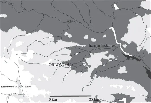
The multi-period prehistoric settlement of Orlovo – Orlovska Chuka (Plate 1a) is located in the south-east part of Bulgaria, just North of the Rhodopes mountain range. In modern terms, the site is located 0.8 km North East of the North Eastern edge of the village of Orlovo, some 12 km South of the town of Haskovo and 25 km North North East of the town of Kardzhali (Plate 2a). The latitude of the site is 41° 57′ 28″, the longitude is 25° 29′ 51″ and by far the greater part of the site lies at an altitude of 230–235 masl. It was discovered in the 1980s by Dimitur Aladzhov (Aladzhov 1997, 200–201), as part of the Haskovo Museum’s independent field survey to provide the basis for a regional settlement history. The Neolithic–Chalcolithic part of the complex covers an area of 1.5 ha and is partly overlain by a 5 m-high Thracian barrow (Plate 1b).
The site and its environment
Site topography
The Turkish toponym of the site –‘Giurush’ – means a ‘very flat place’. The site lies on a high (65 m) terrace of the Harmanlijska reka (Fig. 1.1). It covers several low rises in an East–West series that form the high terrace. The terrace forms an abrupt slope to the North of the site, constraining access to the high-quality pasture of the floodplain (Plate 1c). By contrast, the ground slopes gently to the South, providing excellent arable land (Plate 1a).
Geology
The geological background of the Orlovo site (Plate 2b) is represented by two formations: the Paleogene (2Pg23) coal-bearing and sandy formation and the Neogene (ahN1–2) Akhmatovo formation (Boyanov et al. 1989; 1992).
Southeast of the Orlovo site and near the village of Knizhovnik are outcropping Precambrian metamorphic rocks. They are represented by the Zhulti Chal formation and Lessovo-type gneiss-granites – both rock formations belonging to the Pra-Rhodope Super Group (Boyanov et al. 1989).
The Zhulti Chal formation is some 600–700 m in thickness and composed of fine- to medium-grained biotitic and biotite-muscovitic gneisses, gneiss-schists, schists, amphibolites (in cases with pieces of metamorphosed ultrabasic rocks, serpentinites) and graphite-bearing quartzites. Typical for the formation is the presence of garnet. Later dykes, with a dioritic porphyritic or lamprophyric composition, have been metamorphosed (Boyanov et al. 1992, 11–12).
Among the gneiss-granites which are of a uniform grain structure and granoblastic texture are common xenoliths of amphibolites, serpentinites and gneisses (Boyanov et al. 1992, 13). Their composition is of quartz, plagioclase (oligoclase), microcline and biotite, in cases substituted by sericite, chlorite and a second generation of quartz. They are a product of a regional metamorphism in the amphibolite facies. Porphyroblastic gneisses are known 6–7 km to the East of the site.
The Paleogene coal-bearing and sandy formation is widespread around the village of Orlovo. At its base, there is a layer of conglomerates of a mostly quartz composition and in some cases with gneiss pebbles, followed next by a multiple alternation of yellow-brown or grey sandstones and aleurolites together with conglomerates (Boyanov et al. 1992, 27; see also Goranov and Atanasov 1989). Along the coal-bearing horizons, the colour of the sediments is dark gray and black.
The Neogene sedimentary rocks of the Akhmatovo formation have a transgressive and discordant horizontal position overlying the ancient metamorphic rocks and Paleogene sediments (Boyanov et al. 1992, 44). They are usually pale gray in colour, but yellowish and red hues are also observed. Their composition includes sands, sandstones, clays, limestones and gravels, the most important being the fine- to medium-grained sandstones or loosely-termed sandstones with a clay cement. The mineral composition of the sand is represented by quartz, feldspar, mica, as well as pieces of metamorphic and volcanic rocks, quartz and pegmatite – all with rounded or rough forms. The thickness of the formation has been estimated from 120–150 m to about 350 m and has been related to three mega-cycles of formation (Meotian, Pont-Dacian and Upper Pliocene) (Dragomanov et al. 1984).
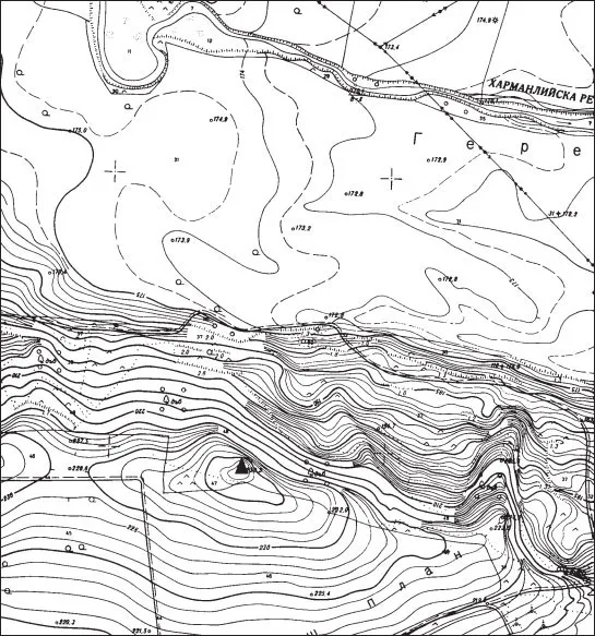
Figure 1.1. Map of Orlovo site (scale: 1:5000). Key: triangle marks position of Thracian barrow at the top of the site
Along the river valleys, there are Quaternary and modern alluvial-proluvial sediments (Holocene) (aQh). The alluvial sediments can vary in thickness up to 30 m, as in the case of stretches of the Maritsa River.
From a tectonic point of view, the Orlovo site is located in the large Harmanli Block with superimposed Paleogene depressions. Small faults with a NW-SE orientation are observed SW of the village of Knizhovnik, but they are covered by sediments at the archaeological site.
The ore field closest to the site is the Spahievo lead-zinc ore field (Maneva 1988), which is located about 18 km to the West. This ore field includes one of the few sources of turquoise in Bulgaria.
Non-metallic mineral raw materials in the area are white granular quartz veins to the East in the village of Bryagovo, coal layers, zeolite-bearing volcanic tuffs, halloysite-kaolinite clays at Gorni Glavanak and very plastic clays with a 10 m thickness of the layers near the town of Harmanli. Bitumenbearing schists (shale oil) with a 20–60 m thickness have been described South of the villages of Orlovo and Mandra (Minchev et al. 1964). The Eastern Rhodopes are also well known as a source for precious and decorative minerals and aggregates – mainly the different varieties of quartz (including amethyst) or chalcedony (including the agates), opal, jasper and related rocks (Petrusenko and Kostov 1992).
Figure 1.2. Hydrological network of the Haskovo area
Hydrology and geomorphology
The Harmanlijska reka is a second-order tributary of the river Maritsa, which it joins some 35 km downstream of the site of Orlovo (at the modern town of Harmanli) (Fig. 1.2). This river is now sluggish, with a low sediment load, which has been strongly affected by the construction of the Thrakiets reservoir 12 km upstream. The river has its sources 35 km upstream of the site, in the Chukata hills, which are foothills of the Eastern Rhodopes.
To the South of the site is the Beklovska River, with the small Knizhovnik dam located just 1–2 km East of the village of Orlovo. Both the Harmanlijska river and its tributary, the Beklovska River, as well as other small rivers, have their origin in the Chukata Range in the Northern part of the Eastern Rhodopes.
From a geomorphological point of view, the Orlovo site is located in the Upper Thracian sub-region of the Thracian–Strandja region of South Bulgaria and related to the Haskovo Hills region (Geografiya na Bulgaria 2002, 395–396).
Communications
In terms of communications, there are no obvious hindrances to movement either way along the river valley, while mobility north across the Thracian Plain is equally unconstrained. However, movement to the South is an entirely different question (Plate 2a). Penetration into the Eastern Rhodopes is readily made, if slow, by following the ridge-top routes between the Virovitsa and Tsiganska streams (the modern villages of Gorno Vojvodino and Most) through to the valley of the river Perperek. Passage South of the Perperek valley to the Aegean drainage is somewhat harder, requiring the crossing of complex upland topography and dense vegetation both in the valleys and on the ridges but not as challenging as the high-mountain terrain of the Central or the West Rhodopes. An alternative route to the Aegean – longer but far easier – is to travel downstream to the river Maritsa and follow that river to the sea – a trip of ca. 100 km.
Modern soils
According to a general soil map of Bulgaria, the Haskovo–Orlovo area falls within a mixture of thicker, more fertile soils – mostly cinnomonic forest soils – of the Central Thracian–Tundja soil province of the Balkan-Mediterranean soil Subregion (Geografiya na Bulgaria 2002, 305) and the shallower rankers, lithosols and smolnitsa of the Haskovo Hills zone (Geografiya na Bulgaria. 2002, 304; see also Sarafov 2000, maps p. 49, 51, 53). The floodplain of the Harmanlijska reka is covered in alluvial meadow soils.
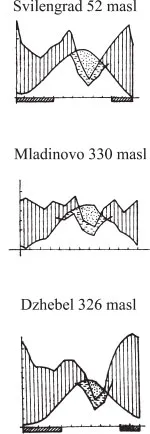
Figure 1.3. Water balance diagram for Svilengrad, Mladinovo and Dzhebel, January–December (source: Bondev 1991). Key: vertical hatching:excess precipitation; dotted areas: potential deficit; horizontal dashes: deficit in precipitation
Modern climate
The modern climatic data are based upon records kept at eight local weather stations in South East Bulgaria over periods between 28 and 58 years (Bondev 1991, 20–46). The modern climate of the region may be characterised as a transitional Continental climatic zone, with long, dry summers and cold, rainy winters. The effect of altitude is only moderately strong in a comparison of the climate in the Orlovo area with that of the surrounding Thracian plain and the Eastern Rhodopes. Mean temperatures for the Haskovo region in July reach a mean 23–24° and for January +1° to 0° (Geografiya na Bulgaria 2002, 170–171). The average year’s amplitude of temperature (the difference between the average temperatures in January and July) for the last 70 years of the 20th century AD is 21–23° (Geografiya na Bulgaria 2002, 148).
The three weather stations of Svilengrad, Mladinovo and Dzhebel (Fig. 1.3) indicate similar trends in seasonal climate, with longer summer water imbalances at Svilengrad, the lowest-lying of the three, and spring and winter peaks in precipitation at Svilengrad and Dzhebel. However, the precipitation is high in all months except July and August at Mladinovo – at a similar altitude to that of Dzhebel (Bondev 1991, figs 12, 14 and 18). The length of drought periods for the full set of eight weather stations (Bondev 1991, tab. 1) indicates a weak correlation with altitude (Fig. 1.4), with little reduction in the length of droughts at Kardzhali despite its location in an inter-montane basin. Interpolation of the altitude of Orlovo (230–235 masl) into this chart indicates the likelihood of a 2–3 month period of summer drought in the valley of the Harmanlijska reka.
These climatic parameters are important for providing a framework for understanding the agricultural potential of these regions in comparison to the climatic features of the Near Eastern, Levantine and Anatolian source areas for the major Neolithic cereal cultivars of South East Europe – viz., the mountains of the subtropics from 25° to 45° North, with their cold winters, wet springs and autumns, as well as hot dry summers (Hawkes 1969, 21). The climatic data also provide support for the notion of a possible summer grazing problem for lowland communities with a strong emphasis on pastoralism. The location of Orlovo at an ecological boundary between the lowlands and the uplands may assume more importance in such periods.
Modern vegetation
As with most lowland areas in modern Bulgaria, there have been major anthropogenic effects on the prehistoric forest since the Iron Age (Chapman et al. 2009). These effects include the expansion of cultivation in the post-War era, so that much of the territory around the site continues to be under intensive arable cultivation. There are remnants of lowland forest cover near the site, as near Sirakovo, 15 km West of the site. The major forested areas, however, lies South of Orlovo, in the foothills of the Eastern Rhodopes (Plate 1d).
In his major survey of the vegetation of Bulgaria, Bondev (1991, 96–97, 119, 134 and Karta 1) outlines three vegetational zones whose remains are represented in the modern anthropogenically-altered flora: flood-plain forests including small-leaved elm (Ulmus minor Mill.), Caucasian ash (Fraxinus oxycarpa Willd.) and long-thorned oak (Quercus pedunculiflora C. Koch); lower terraces, with mixed oak forests of Quercus cerris L. (Turkey oak) and Quercus frainetto Ten. (Hungarian oak); and higher terraces, with similar mixed oak forest but with elements of the Mediterranean flora such as juniper (Juniperus oxycedrus L.), bladder senna (Colutea arborescens L.) and false senna (Coronilla emerus L.).
The regional topographical context
The Orlovo site lies close to an ecological boundary, marked by the Northern edge of the foothills of the Eastern Rhodopes (Plate 2a). In this part of the Rhodopes, the boundary of the first range from the Thracian Plain travelling South – the modern ‘Chukata’ – lies less than 10 km South West of the site. Thus, all of the notional 5–km territory of the Orlovo site is located in a largely arable zone with high potential for pastoralism. Within one day’s round trip (10 km maximum distance from the site), there is access to additional pasture, as well as upland stone resources. Longer visits of up to 20 km would have been necessary to access the full range of rock sources for tools and ornaments. Thus, the site occupies an important place on the Southern margins of the arable zone of the Thracian Plain and just North of the Northern margins of an upland zone rich in rocks and minerals. This is, of course, also the case for the Haskovo region as a whole, making the region of considerable interest in prehistoric exchange between upland and lowland zones with complementary resources (cf. Sherratt 1972; Chapman 1981).
However, there is a paradox about the Eastern Rhodopes: while proclaiming itself in terms of its topography, vegetation, soils and, most particularly geology, the Eastern Rhodopes contains a number of inter-montane basins which are only 100–120 m higher than the Southernmost parts of the Thracian Plain, such as the Orlovo area. While both the Central and Western Rhodopes boast mountain peaks over 2000 m in altitude (Goljam Sjutkya at 2,186 m; Goljam Perelik at 2,191 m), the highest peak in the Eastern Rhodope is Tikla, with a peak rising to 744 m. The terrain of the Kardzhali basin varies from 350–500 masl, while that of the Krumovgrad basin is similar. Thus the Eastern Rhodopes are not so much classic mountain terrain as rolling foothills with a sizeable proportion of flat, fertile land.
Palaeo-environment
Direct data for the palaeo-environment of the Haskovo region and the Orlovo site are not as yet available. Recent motorw...