Combining Atlantic and imperial perspectives, Caribbean New Orleans offers a lively portrait of the city and a probing investigation of the French colonists who established racial slavery there as well as the African slaves who were forced to toil for them. Casting early New Orleans as a Caribbean outpost of the French Empire rather than as a North American frontier town, Cécile Vidal reveals the persistent influence of the Antilles, especially Saint-Domingue, which shaped the city’s development through the eighteenth century. In so doing, she urges us to rethink our usual divisions of racial systems into mainland and Caribbean categories.
Drawing on New Orleans’s rich court records as a way to capture the words and actions of its inhabitants, Vidal takes us into the city’s streets, market, taverns, church, hospitals, barracks, and households. She explores the challenges that slow economic development, Native American proximity, imperial rivalry, and the urban environment posed to a social order that was predicated on slave labor and racial hierarchy. White domination, Vidal demonstrates, was woven into the fabric of New Orleans from its founding. This comprehensive history of urban slavery locates Louisiana’s capital on a spectrum of slave societies that stretched across the Americas and provides a magisterial overview of racial discourses and practices during the formative years of North America’s most intriguing city.
- 496 pages
- English
- ePUB (mobile friendly)
- Available on iOS & Android
eBook - ePub
About this book
Trusted by 375,005 students
Access to over 1.5 million titles for a fair monthly price.
Study more efficiently using our study tools.
Information
CHAPTER ONE
A Port City of the French Empire and the Greater Caribbean
In 1765, at sundown, while walking down Bourbon Street, a white resident of New Orleans, Sieur Xavier Duverger de Saint-Sauveur, met a black man wearing a sword. Since a local regulation based on the Code Noir forbade slaves to bear arms and required whites to intervene in the event of a violation, he questioned the man, whom he took for a local slave. It is also possible that this prohibition had been extended to free men of color, as had been the case in Saint-Domingue since at least 1758. When the black man, whose name was Antoine, refused to be led to his master, Duverger threatened to take him to jail. Resenting this act of dishonor, Antoine objected to being treated like a “dog,” insulted his opponent, and tried to engage him in a fight. The white man then beat him with his cane and, with the assistance of a passerby, took him to prison. According to Duverger, when the guard arrested the lawbreaker, the latter protested “that he [Antoine] had a certain social standing, that he came from Paris and had influence and that he [Duverger] would pay for it.” After the Superior Council had investigated the case, Antoine was discharged, maybe because of his origins. He told the judge that he was a twenty-eight-year-old Catholic “free negro” from the “Senegal nation” and that he had come to Louisiana as a sailor on the ship L’espérance, which sailed between Lorient, Cap-Français, Havana, and New Orleans. He complained that “it was unfortunate that he was brought to jail in such a manner, being of negro condition, and since his father supplied the French with negroes.” He was probably related to a habitant (permanent resident) of Gorée or Saint-Louis in Senegambia who sold captives to the Company of the Indies.1
In this conflict over race and honor, the two protagonists had antagonistic visions of the social order: one that was locally rooted and an alternative that was the fruit of a life spent traveling between West Africa, metropolitan France, and the French and Spanish Caribbean. Paradoxically, Antoine’s life history and job as a sailor took him to all the places in Europe, Africa, and the Americas with which New Orleans maintained, at various times, close connections. His social background and mobility, nevertheless, gave him a degree of self-respect and dignity that was denied to most blacks in the Louisiana port city. Although Antoine and Duverger did not share the same experience and worldview, their encounter probably left an imprint on both men. It would be presumptuous to assume that they were transformed by their clash, but one can postulate that it was the multiplication of similar interactions between local actors and outsiders that made New Orleans the singular place it became during the French regime. Their conflict illuminates the problematic relationship that the local and the extralocal maintained in the Atlantic world: people’s lives were shaped and places constructed by a complex and dynamic combination of mobility and sedentariness, of openness to the outside world and rootedness.
Racial formation in New Orleans did not take place in isolation from the rest of the Atlantic world. The Louisiana capital and its colony were no different from other new societies established by Europeans in the Americas. All of them were migratory communities that were being made and remade by the continuous arrivals and departures of migrants, but their links with Europe, Africa, and other regions in the Western hemisphere were maintained by circulation of all kinds. The combined mobility of people, goods, capital, and information, not transatlantic migrations alone, constantly transformed these new societies. A series of technical, political, geopolitical, economic, and sociocultural factors, however, constrained these various movements, posing two multilayered questions. How did the location and history of New Orleans determine the nature, direction, and intensity of the connections the port city was able to maintain with the rest of the Atlantic world throughout the French period? And were imperial or transimperial relationships most influential in shaping the way New Orleans’s society developed?2
From the seventeenth century onward, the greater Caribbean came to constitute an Atlantic crossroads. The Spanish, English, French, and Dutch Empires all intersected in the region as various maritime circuits linked the islands and their mainland surroundings in transimperial networks. Caribbean geography made it difficult for imperial states to enforce their trade monopolies. Smuggling thrived, both the illicit trade by northwestern Europeans with Spanish colonies and that between English, French, and Dutch settlements. One of the primary motivations behind the Dutch, English, and French presence in the region was to compete with the Spanish for New World resources and to acquire some of Spain’s colonial riches for themselves. As a result, some historians consider contraband to be the main force that shaped the Caribbean. Yet New Orleans did not become a Caribbean port city because of its participation in smuggling. Its commerce with nearby Spanish colonies did grow over time, but it remained secondary. Located on the fringe of the main trading circuits of the greater Caribbean and deprived of a group of powerful merchants, the Louisiana capital failed to oust English and Dutch hubs as a leader in Spanish trade.3
What gave New Orleans its Caribbean character was racial slavery. In the early eighteenth century, local authorities and settlers on Saint-Domingue, acting against the wishes of the French minister of the navy, Jérôme de Pontchartrain, determined to pursue an economy based on sugar, rather than continue to chase the elusive “Spanish mirage” and attempt to make a fortune off illicit trade with the wealthy Spanish Empire. This decision would profoundly impact Louisiana. Already familiar with the big island, a necessary stop on the sea road from Europe or Africa to New Orleans, the Mississippi colony sought to develop an export economy based on plantation slavery, directed toward the metropole, and modeled on that of Saint-Domingue’s. This social and economic choice, combined with New Orleans’s relative isolation, explains why French imperial relationships remained the most important for the port city throughout the French period.4
Within this French imperial framework, connections between the colony and its metropole were increasingly replaced by intercolonial exchanges. Before 1731, the Company of the Indies made a real effort to populate the territory with both free and forced migrants from metropolitan France and from its slave-trading outposts in Senegambia. Once the company released its trade monopoly and ceased to transport African slaves to the Mississippi colony after 1731, interactions between New Orleans and the Antilles grew in importance. These ever-closer ties between the port city and the Caribbean continued and reinforced the direct influence that the islands had already exerted on Louisiana with the promulgation of a modified version of the Antillean Code Noir in 1724. The horizons of all New Orleans’s urban dwellers quickly came to include the French islands as well as Europe and Africa. For them, Saint-Domingue became the most important imperial center after the metropole.
THE MISSISSIPPI COLONY: A LATECOMER ON THE PERIPHERY OF SAINT-DOMINGUE
In 1681, Abbé Claude Bernou, a contributor to the Gazette, allegedly supervised the production of a beautiful map depicting North America and part of South America. Employed by the offices of the ministry of the navy, he corresponded with René-Robert Cavelier de La Salle and wrote many reports to support La Salle’s expeditions in the Mississippi Valley. The map is remarkable for several reasons. First, it represented all the territories explored and settled by the French since the start of the seventeenth century in relation to nearby English and Spanish colonies. Second, the map was painted while La Salle was on his way to the Gulf of Mexico during his second expedition through the Mississippi Valley. In the painting, the Mississippi River stops at the latitude of the Ohio River, with a blank space instead of its southern half. The map suggests the promise of a future Louisiana and highlights that the exploration of the Mississippi Valley was initially undertaken as part of the western expansion of New France toward the Great Lakes and beyond. Yet, lastly, the map, which is centered on the Caribbean Sea and the Gulf of Mexico, also serves as a reminder that, after the Mississippi Delta had been reached in 1682, La Salle’s third and final expedition three years later came from the sea. Thereafter, most of the connections that Lower Louisiana maintained with the rest of the Atlantic world took the seaway. This maritime route was long and perilous and necessarily involved stops in the Antilles, which fostered the development of intercolonial relations between New Orleans and the islands. Founded at the very end of the seventeenth century and located on the western edge of the French Empire, Louisiana might have managed to overcome the competition with older and better located colonies in Canada and in the Caribbean if the grandiose plans imagined by John Law, a Scottish financier and adviser to the French regent, had succeeded, but they failed. As a result, the Mississippi colony remained in a peripheral position vis-à-vis Saint-Domingue.5
In the sixteenth century, all French attempts to establish colonies in the New World came to unsuccessful conclusions. The wealth, pomp, and brilliance of Italy exercised a much greater pull on the French crown during the first half of the century. Afterward, the Wars of Religion deterred all ambitious overseas policy. It was not until peace was restored that Henri IV and then Richelieu, under Louis XIII, supported a program of commercial and maritime expansion driven by mercantilist theories. France then joined England and the Netherlands in their efforts to challenge the Iberians’ colonial monopoly. The French first started to settle Nova Scotia and the Saint Lawrence Valley in the early years of the seventeenth century, founding Quebec City in 1608 and Montreal in 1642. They also began to take hold in the Caribbean in the mid-1620s. From their original base in Saint-Christophe (1625), the French moved to Guadeloupe (1635), Martinique (1638), and then several smaller islands. Saint-Domingue did not formally become a French colony until later. Although buccaneers and freebooters, including many French, lived on Tortuga and the northern coast of the big island from the 1620s onward, French officials only succeeded in imposing their authority in 1655. The Spanish finally recognized the sovereignty of the French on the western side of the island by the Treaty of Ryswick in 1697. In addition to pursuing trade with the Spanish, the French islands in the Caribbean quickly sought to develop plantation economies growing tobacco, cotton, and other plants with a workforce of European indentured servants and increasingly African slaves, whereas the main economic motivation in Canada was the fur trade.6
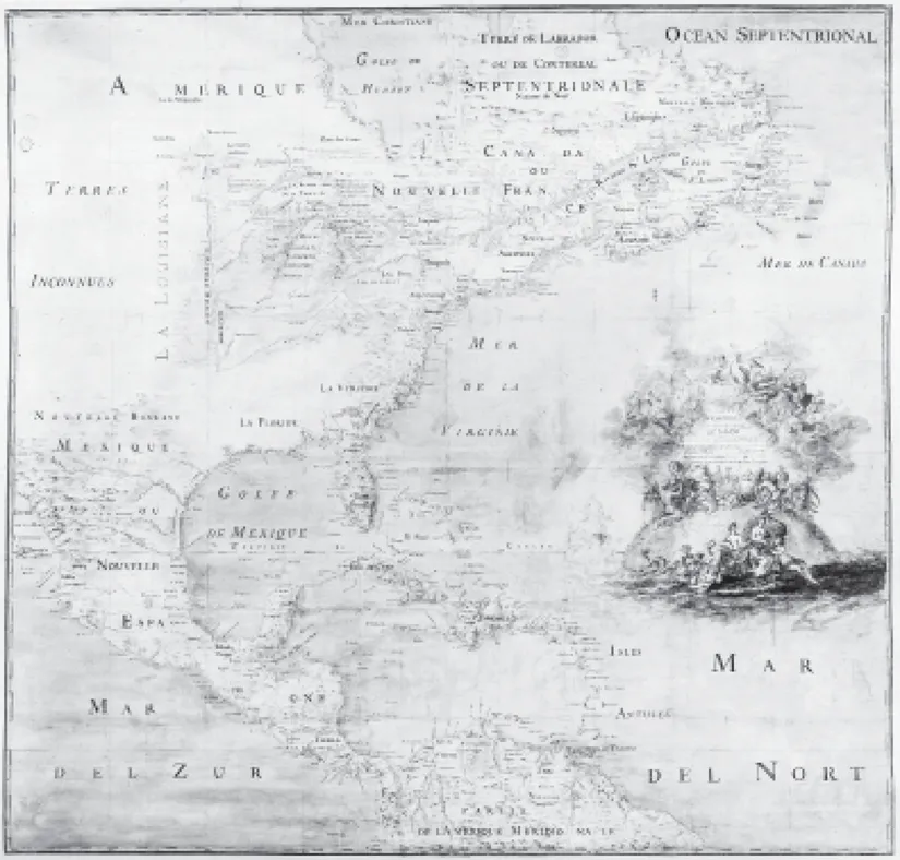
Figure 3: [Claude Bernou]. Carte de l’Amérique septentrionale et partie de la méridionale depuis l’embouchure de la rivière St Laurens jusqu’à l’isle de Cayenne avec les nouvelles découvertes de la rivière de Mississipi ou Colbert. Circa 1681. Département cartes et plans. CPL SH 18E PF 122 DIV 2 P 0 RES. Courtesy of Bibliothèque nationale de France. Paris
France’s two separate colonial domains in Canada and the Caribbean were brought together for the first time by La Salle’s third and final expedition in 1685–1687. Until the destruction of Huronia by the Iroquois in the late 1640s, Native Americans came to Quebec City or Trois-Rivières to exchange furs and pelts for European merchandise. Afterward, French traders traveled beyond the falls of Lachine to collect furs and pelts within indigenous villages in the Great Lakes region. La Salle was one of the adventurers and entrepreneurs who participated in the development of new trading circuits in the Upper Country. Following the success of his first two expeditions, he obtained the support of the king to establish a colony in the lower Mississippi Valley and decided to reach the Mississippi Delta by sea. La Salle’s expedition, however, ended as a disaster, and it was only in 1699 that the first settlement was established by Pierre Le Moyne d’Iberville. Despite the participation of some freebooters, sailors, and soldiers from Saint-Domingue in d’Iberville’s expeditions and the shipment of food to the colony during its early years, the French section of the island did not play a direct role in Louisiana’s founding. Still, geography and technology immediately tied the Mississippi colony’s fate to Saint-Domingue.7
With the construction of Fort Maurepas (now Biloxi), Louisiana became the French Empire’s most remote American colony, as the Gulf route from the Antilles added 1,000 kilometers to the 6,600 already separating the islands from the metropole. After the founding of New Orleans in 1718, further inland, and its promotion to the status of colonial capital in 1722, the distance between France and the nascent colony included another 160 kilometers. La Balise, a small outpost, was built in 1723 at the mouth of the Mississippi, but it was used not so much as an outer harbor for New Orleans as a last stop before sailing upriver. Because navigation in the Gulf of Mexico and on the Mississippi River was particularly hazardous, a pilot in charge of guiding sea ships through the delta resided there permanently. In his travel account, Company of the Indies employee Marc-Antoine Caillot compared his experience accompanying a flotilla of small boats loaded with slaves from La Balise to New Orleans to an encounter with three of the four Horsemen of the Apocalypse. Once in the city, he expressed his relief at having left the “war, plague, and famine we faced during this little trip. War, because it had been necessary for us to have a stick in hand to keep the Negroes under control; plague, for the stench that the scurvy-ridden people had given to us; and famine, because as a rule we had nothing to eat.” Caillot landed in New Orleans after eight days of hardship, but, according to Antoine-Simon Le Page du Pratz, the journey between La Balise and the colonial capital could take as long as one month. Although in theory it should have been possible to sail from France to New Orleans in about twelve weeks, in practice, the average crossing amounted to seventeen weeks, one-third to double the usual seven to nine weeks necessary to reach the Antilles.8
Given the difficulties navigating the Gulf of Mexico and the Mississippi, all ships coming to New Orleans from Europe or Africa had to stop in a Caribbean port before heading to the Louisiana capital to repair damage and to stock up on water, wood, and food supplies. The former officer and planter Jean-François-Benjamin Dumont de Montigny underscored this necessity in bad verse at the beginning of the fourth canto of his poem entitled “L’établissement de la province de la Louisiane” (“The Settlement of the Province of Louisiana”): “When, from some port city, one sees some ships / Travelling by sea sailing with the current / Wanting to reach New France [Louisiana] / Braving winds and perils, one therefore comes / To look for Cap-Français, where taking water / And fresh supplies, that is everything that is needed / to at least complete the rest of the journey. …” Most often these stops took place in a port on Saint-Domingue, either at Cap-Français on the northern coast of the island or sometimes Les Cayes in the southern province. During the return trip, vessels could also stop in Léogane, and, beginning in 1749, Port-au-Prince. Stays on the island lasted several days or even weeks.9
In addition to the close ties between Louisiana and Saint-Domingue formed by sea-lanes, the two colonies were originally founded with the same goal. At the turn of the century, the development of trade with Spanish territories was one of the primary objectives of French colonial expansion in the greater Caribbean. This impetus explains both the creation of the Company of Saint-Domingue in 1698 and the establishment of Louisiana in 1699. Spain did not provide its American colonies with enough manufactured goods, especially fabrics, to meet their needs while the latter produced the silver that was highly sought after by rival European powers. Curaçao and Jamaica dominated this contraband trade. In the second half of the seventeenth century, Port Royal, in particular, used its strategic location in the heart of the Spanish West Indies to develop a dual economy based on the export of agricultural products and trade with Spanish colonies. But the Jamaican port city was destroyed by an earthquake in 1692. Founded a few years later and ideally located to trade with Pensacola, Havana, Veracruz, and Campeche, Mobile and, later, New Biloxi, Louisiana’s first and second capitals before New Orleans, could have taken the place of Port Royal, leaving the commerce of Cartagena to the southern province of Saint-Domingue and that of the South Sea to merchants from Saint-Malo. Yet, by the time New Orleans emerged, the situation had changed. The Treaty of Utrecht (1713) gave the asiento (the agreement to furnish Spanish colonies with slaves) to the British, which facilitated smuggling with Spanish territories.10
Although Louisiana could not compete with Jamaica, the monarchy still hoped it could benefit from the colony’s exploitation. A few years after the end of the War of the Spanish Succession, an ambitious and grandiose imperial project was assigned to the Mississippi colony by the Company of the West, which was granted its trade monopoly in 1717. Louisiana was intended to play a crucial role in the global sociopolitical, financial, and economic schemes of John Law. To conceive and implement his plan of turning France into a commercial nation, th...
Table of contents
- Cover Page
- Title Page
- Copyright Page
- Dedication
- Contents
- Acknowledgments
- List of Illustrations
- Abbreviations
- Introduction. When the Levees Rose
- Chapter 1. A Port City of the French Empire and the Greater Caribbean
- Chapter 2. The City with Imaginary Walls: The Natchez Wars, Slave Unrest, and the Construction of a White Urban Community
- Chapter 3. The Hustle and Bustle of City Life: The Politics of Public Space and Racial Formation
- Chapter 4. “The Mulatto of the House”: The Racial Line within Domestic Households and Residential Institutions
- Chapter 5. “A Scandalous Commerce”: The Disorder of Families
- Chapter 6. “American Politics”: Slavery, Labor, and Race
- Chapter 7. “Everybody Wants to Be a Merchant”: Trade, Credit, and Honor
- Chapter 8. Lash of the Tongue, Lash of the Whip: The Formation and Transformation of Racial Categories and Practices
- Chapter 9. From “Louisians” to “Louisianais”: The Emergence of a Sense of Place and the Racial Divide
- Conclusion. From Louisiana to Saint-Domingue and from Saint-Domingue to Louisiana
- Index
Frequently asked questions
Yes, you can cancel anytime from the Subscription tab in your account settings on the Perlego website. Your subscription will stay active until the end of your current billing period. Learn how to cancel your subscription
No, books cannot be downloaded as external files, such as PDFs, for use outside of Perlego. However, you can download books within the Perlego app for offline reading on mobile or tablet. Learn how to download books offline
We are an online textbook subscription service, where you can get access to an entire online library for less than the price of a single book per month. With over 1.5 million books across 990+ topics, we’ve got you covered! Learn about our mission
Look out for the read-aloud symbol on your next book to see if you can listen to it. The read-aloud tool reads text aloud for you, highlighting the text as it is being read. You can pause it, speed it up and slow it down. Learn more about Read Aloud
Yes! You can use the Perlego app on both iOS and Android devices to read anytime, anywhere — even offline. Perfect for commutes or when you’re on the go.
Please note we cannot support devices running on iOS 13 and Android 7 or earlier. Learn more about using the app
Please note we cannot support devices running on iOS 13 and Android 7 or earlier. Learn more about using the app
Yes, you can access Caribbean New Orleans by Cécile Vidal in PDF and/or ePUB format, as well as other popular books in History & Early American History. We have over 1.5 million books available in our catalogue for you to explore.