Winner of a 2017 Louisiana Endowment for the Humanities Book of the Year Award
This book represents the first time that the known history and a significant amount of new information has been compiled into a single written record about one of the most important eras in the south-central coastal bayou parish of Terrebonne. The book makes clear the unique geographical, topographical, and sociological conditions that beckoned the first settlers who developed the large estates that became sugar plantations. This first of four planned volumes chronicles details about founders and their estates along Bayou Terrebonne from its headwaters in the northern civil parish to its most southerly reaches near the Gulf of Mexico. Those and other parish plantations along important waterways contributed significantly to the dominance of King Sugar in Louisiana.
The rich soils and opportunities of the area became the overriding reason many well-heeled Anglo-Americans moved there to join Francophone locals in cultivating the crop. From that nineteenth century period up to the twentieth century's side effects of World Wars I and II, Hard Scrabble to Hallelujah, Volume I: Bayou Terrebonne describes important yet widely unrecognized geography and history. Today, cultural and physical legacies such as ex-slave-founded communities and place names endure from the time that the planter society was the driving economic force of this fascinating region.
eBook - ePub
Hard Scrabble to Hallelujah, Volume 1: Bayou Terrebonne
Legacies of Terrebonne Parish, Louisiana
- 500 pages
- English
- ePUB (mobile friendly)
- Available on iOS & Android
eBook - ePub
Hard Scrabble to Hallelujah, Volume 1: Bayou Terrebonne
Legacies of Terrebonne Parish, Louisiana
About this book
Trusted by 375,005 students
Access to over 1.5 million titles for a fair monthly price.
Study more efficiently using our study tools.
Information
CHAPTER ONE
The very origin of the landscape of Terrebonne Parish in south central Louisiana gave rise to the lucrative sugar industry that peaked locally in the nineteenth century and still endures in lesser eminence today. Sugar cane production in the region dates back to before the time the Louisiana legislature established Terrebonne as a parish (county) in 1822.
Built as delta land of the unfettered Mississippi River over the course of unknown centuries, Terrebonne Parish’s fertile land was fed by siltation from Bayous Lafourche and Terrebonne, both distributaries of the Mississippi. On the western limits of the parish, the same scenario occurred through delta-building action of the Atchafalaya River, which is itself a powerful distributary of the Mississippi.
The arable land thus built by the 1700s was particularly fruitful along the bayous of various lengths that transect the parish, from twenty to fifty miles long. The most important of these is Bayou Terrebonne, 50 miles in distance from its headwaters at Bayou Lafourche to Sea Breeze at the Gulf of Mexico. Fertile land rested along these bayous which were hugged by high headlands that tapered downward to swamps and wetlands on both banks. Each bank generally had a “strip of high ground from a quarter to one mile in width”1 parallel to the bayou.
While this geography could have been limiting in the relatively narrow widths of acreage friendly to cultivation along the bayous, the landscape more than made up for that limitation by existence of the natural waterways that allowed shipping of produce by flatboat, and, farther upstream, by steamboats. This was imperative at the beginning of sugar cane cultivation, especially, since adequate roadways were nonexistent in the coastal parish during early settlement. Bayous also served as natural drainage for arable lands along their banks.
However, one source wrote that the head of Bayou Terrebonne, “as were those of the other area bayous, Blue, Petit Black, Chacahoula, was silted over long before the coming of the white men.”2 Just as the Mississippi fed the Lafourche and the Lafourche fed the Terrebonne in the long-ago geological past, Bayou Terrebonne was the source of all the major bayou waterways in Terrebonne Parish. Those that had their direct source from Bayou Terrebonne are Bayou Black (Little and Big), Bayou Grand Caillou, Bayou Little Caillou, Bayou Cane, and Bayou Pointe-aux-Chênes. Bayou Black, in turn, gave rise to Bayou Buffalo (Dularge) and Bayou Chacahoula. Bayou Blue had its source from Bayou Lafourche and paralleled Bayou Terrebonne for a distance, but it is not a distributary of the Terrebonne.
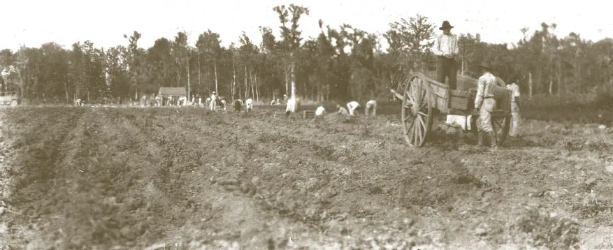
Potato farm Bayou Black 1920
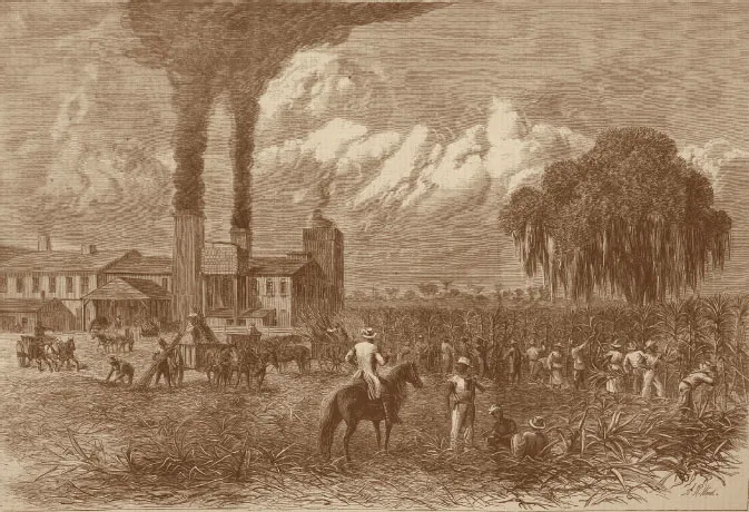
The Sugar Harvest, A.R. Waud Harper’s Weekly, 1875
First recorded inhabitants of the area were the Native American Houmas tribe which had drifted after 1784 into what was to become Terrebonne3. A few hardy French families, “principally from the older colonies of Louisiana,” inhabited the lower reaches of the parish by the late 1700s4, establishing their homesteads not far from the Gulf of Mexico coast. Possessors of land grants who had received them for service in the Revolutionary War when Louisiana was a Spanish colony, and some for other reasons, also settled there. Others, many of them Acadians from Nova Scotia, traversed neighboring Lafourche and St. Mary parishes to settle along other Terrebonne bayous in what was then known as the Lafourche Interior.
Historian Alcee Fortier listed the first settlers of Terrebonne Parish as Royal Marsh on “Black bayou,” the “Boudreaus” on Little Caillou and the Terrebonne, the Belanger family along lower Terrebonne, Prevost, who “started a plantation on Grand Caillou,” the “Shuvin [Chauvin] family on Little Caillou, the “Marlboroughs” in the northern part of the parish, and other sections’ settlers Curtis Rockwood, the D’Arbonnes, LeBoeufs, Trahans, Bergerons, R.H. and James B. Grinage near Houma.5
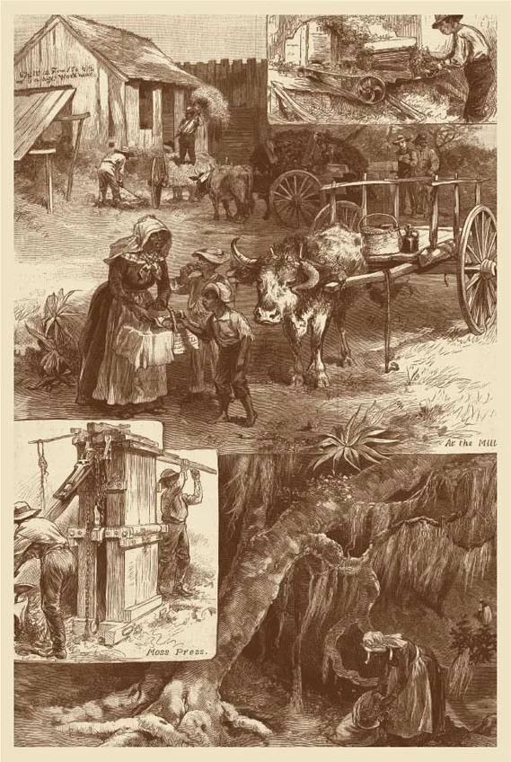
The Moss Industry in the South, Harper’s Weekly, 1882
Those people were overwhelmingly Acadians (Cajuns) who had been expelled from Nova Scotia for not swearing allegiance to the English monarch, and some Creoles (Louisianaborn descendants of European ancestry), with a sprinkling of “Americans, Spaniards and Germans.”5
The great majority of inhabitants until the second quarter of the 1800s were subsistence farmers who grew cotton, corn, rice, peas and fruits of all kinds. Adequacy, not bounty, seems to have been the status quo in Terrebonne from its early settlement in the last days of the 1700s. It took almost two decades after New Orleans planter Etienne de Boré achieved granulation of sugar in 1795 for the parish to begin cultivation of the white gold with which the local area was so identified for more than a century, and which has a healthy presence even today.
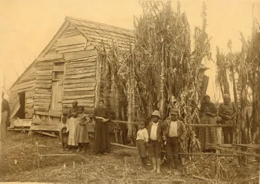
Negro cabin Terrebonne Parish c. 1900
At one time in the bayou-webbed civil parish, more than 100 plantations, many of them each worked by only one man and his family, hugged the water transportation corridors fanning out from the parish seat in all directions. Most were of modest acreage on properties abutting each other from bayou headlands.
But as the parish grew, the countryside was made majestic by the unbroken view of verdant fields in an area renowned for its status in the state’s Sugar Bowl. The sheer expanse of waving greenery can be imagined from the fact that in its agricultural heyday, 1830s-1920s, the civil parish was then the largest of the state with its 2,080 square miles, larger than the entire state of Delaware.
Terrebonne’s vast reaches of pristine arable land later became a magnet for more materially ambitious planters from points north and east who settled in Terrebonne to amass sweeping estates. Some locals, and many newcomers, developed sugar estates and large, even grand, homes. The architecture of their homes ranged from Greek Revival to Queen Anne to Louisiana Raised Cottage, to Eastlake, to Colonial Revival, to early Victorian styles, adorning the bayou landscapes among their fields.
Among findings of the 1850 U.S. Census is that Terrebonne Parish was the site of 550 dwellings that year, mostly families. Population was totaled for persons who lived along the various bayou corridors of the parish. Bayou Terrebonne had 1149 people along its banks; Bayou Black, 906; Bayou Little Caillou, 717; Bayou Grand Caillou, 109; Bayou Dularge, 77; Bayou Pointe-aux-Chênes, 27; Bayou Bleu, 22; Bayou Grand Coteau, 18.
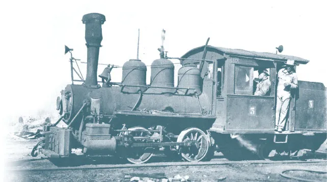
Southdown Engine #5 c. 1920
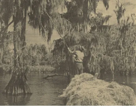
Picking moss 1937
By far, Terrebonne farmers (302) and laborers (223) exceeded the numbers of other occupations, according to 1850 U.S. Census figures. Not surprisingly, overseers, carpenters, and coopers (44, 42, and 36, respectively) were the next most numerous occupational group, since those jobs were vital to plantation operation.
After the Civil War, estates were broken up and sold off, either by owners or the Freedmen’s Bureau. Many stately homes were abandoned, and owners moved away. The sugar farmers who survived were, for the most part, producers with small estates whose families had traditionally worked the land themselves, not relying on slave labor. Mosaic sugar cane disease finished off many planters in the early part of the 20th century.
It is important to know that only a few substantive reminders of Terrebonne’s once-eminent status in national sugar production remain, and whereas at one time sugar houses were common on almost every plantation, not even one sugar house still exists in the parish. This, in spite of the fact that sugar cane remains the dominant local crop.
By 1901, twenty-three gas wells had been drilled in Terrebonne Parish, thereby marking the beginning of the shift from white gold’s dominance to that of black gold in the local economy. Oil and gas production reached its zenith locally in the mid-1900s and beyond.
Today’s residents who drive past Honduras School on Grand Caillou Road, Greenwood School at Gibson, and St. Bridget Catholic Church in Schriever may not be aware that those places are among vestiges of “high sugar” days, surviving only through names that once signified different land owners’ holdings.
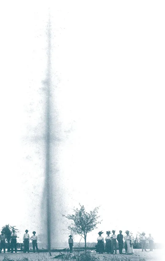
Lirette Field blowout 1908
Communities identified on signage or by locals as Hallelujah, Peterville, Levy Town, and other ...
Table of contents
- Cover
- Title Page
- Copyright
- Acknowledgements
- Dedication
- Table of Contents
- Foreword
- Chapter One
- Chapter Two
- Land Measurement Terms
- Ownership Sources
- Sugar Crops in Terrebonne Parish
- Malbrough Settlement
- Sargeant-Armitage
- Johnson Ridge
- Ducros-Julia
- Schriever
- Waubun-Magnolia Grove
- St. George
- Balsamine
- Hobertville
- St. Bridget
- Isle of Cuba
- Evergreen
- Hedgeford
- Gray
- Bernard’s Open Kettle Syrup & LaCuite
- Beattie-Batey
- Halfway
- Ayo
- Orange Grove-Pilié
- Bayou Cane
- Gabriel J. Montegut II Residence
- Wade Claim
- Barataria Canal
- Joseph Haché Claim-City of Houma
- Houma Additions
- Burguières, Smith, St. Martin Houses
- Magnolia Cemetery-Terrebonne Memorial Park
- Homestead
- Joseph A. Gagné House
- Daigleville
- Residence
- Mechanicsville-Barrowtown
- RobertaGrove
- U.S. Naval Air Station (LTA) Houma
- Prisoner of War Camps
- Myrtle Grove
- Presqu’ile
- Frontlawn
- Edmund Fanguy
- Oakwood (Semple & Shields)
- Pecan Grove
- Bourg
- Bourg Agricultural School
- LeCompte Property-Billiot Claim
- Rural Retreat
- St. Agnes
- Klondyke
- Hope Farm
- Bayou Pointe-aux-Chênes
- Deroche Brothers Syrup Mill
- Aragon
- St. Peter’s Baptist Church
- Pointe Farm
- Lower Terrebonne Refinery
- Montegut-le Terrebonne Sandersville/Crochetville
- Angela
- Magenta
- Eliza
- Sunbeam
- Live Oak
- Dugas Cemetery
- Hard Scrabble - “Caillou Field”
- Humble Canal
- Argene
- Red Star
- Orange Grove
- Methodist Mission Chapel
- Pointe-au-Barré
- Eloise
- Pecan Tree
- Lapeyrouse Canal & Store
- Boyne Boat Works
- Rhodes Brothers
- Madison Canal
- Bush Canal
- End of the Road
- Sea Breeze
- Afterword
- About the Authors
- Index
- Photo Credits
Frequently asked questions
Yes, you can cancel anytime from the Subscription tab in your account settings on the Perlego website. Your subscription will stay active until the end of your current billing period. Learn how to cancel your subscription
No, books cannot be downloaded as external files, such as PDFs, for use outside of Perlego. However, you can download books within the Perlego app for offline reading on mobile or tablet. Learn how to download books offline
Perlego offers two plans: Essential and Complete
- Essential is ideal for learners and professionals who enjoy exploring a wide range of subjects. Access the Essential Library with 800,000+ trusted titles and best-sellers across business, personal growth, and the humanities. Includes unlimited reading time and Standard Read Aloud voice.
- Complete: Perfect for advanced learners and researchers needing full, unrestricted access. Unlock 1.5M+ books across hundreds of subjects, including academic and specialized titles. The Complete Plan also includes advanced features like Premium Read Aloud and Research Assistant.
We are an online textbook subscription service, where you can get access to an entire online library for less than the price of a single book per month. With over 1.5 million books across 990+ topics, we’ve got you covered! Learn about our mission
Look out for the read-aloud symbol on your next book to see if you can listen to it. The read-aloud tool reads text aloud for you, highlighting the text as it is being read. You can pause it, speed it up and slow it down. Learn more about Read Aloud
Yes! You can use the Perlego app on both iOS and Android devices to read anytime, anywhere — even offline. Perfect for commutes or when you’re on the go.
Please note we cannot support devices running on iOS 13 and Android 7 or earlier. Learn more about using the app
Please note we cannot support devices running on iOS 13 and Android 7 or earlier. Learn more about using the app
Yes, you can access Hard Scrabble to Hallelujah, Volume 1: Bayou Terrebonne by Christopher Everette Cenac Sr.,Claire Domangue Joller in PDF and/or ePUB format, as well as other popular books in History & North American History. We have over 1.5 million books available in our catalogue for you to explore.