To the casual visitor of today, Sandwich appears as simply a small inland market town on the bank of a modest river. But locals and historians have long known that in the Middle Ages it was a strategic and commercial seaport of great significance, trading with northern Europe and the Mediterranean and growing prosperous on this business. The medieval fabric of the town has been preserved to a remarkable extent, but historians and archaeologists have never agreed on quite where the first settlement was located. Nor has there been close study of what the surviving medieval buildings can tell us about Sandwich's development. It is the physical development of Sandwich that forms the focus of this volume, providing new theories on how, when and why the town came to take its present form. As well as providing a great amount of detail on the houses, churches and defences of medieval Sandwich, the authors apply the material evidence in order to draw out important social, economic and cultural facets in the evolution of the town. The study of Sandwich also has much wider implications, as despite being largely affected by its location, it also shared much with other English medieval towns in terms of its physical growth and the role of its major institutions. The story of the town, therefore, is both particular and general, and this detailed study gives new insights into the influences affecting urban development, both in the formative period of growth and in later periods in which towns adapted to new circumstances. The method presented here could therefore, be equally applicable to studies of other medieval towns. Maps, plans and photographs, all in full colour, supplement the text and graphically underline many of the conclusions.
eBook - ePub
No longer available
Sandwich - The 'Completest Medieval Town in England'
A Study of the Town and Port from its Origins to 1600
This book isn’t in the library right now, search for another
- 352 pages
- English
- ePUB (mobile friendly)
- Available on iOS & Android
eBook - ePub
No longer available
Sandwich - The 'Completest Medieval Town in England'
A Study of the Town and Port from its Origins to 1600
About this book
Trusted by 375,005 students
Access to over 1.5 million titles for a fair monthly price.
Study more efficiently using our study tools.
Information
Subtopic
European Medieval HistoryIndex
HistoryPART I: INTRODUCTION
1 Background to the Sandwich project
1.1 The project and its aims
Sandwich lies in north-east Kent, about 3km from the coast and approximately 15km east of Canterbury, to which it is connected by the modern A257. This is the successor of the Roman road from Canterbury to Richborough, a branch of which continued to be used in the Middle Ages (Fig. 1.1). But of more importance to the town in its early years were water communications with London, Canterbury, the south coast and the Continent, for which Sandwich, located at the foot of the dip slope of the North Downs on the south bank of the river Stour and the shores of the former Wantsum Channel, was ideally situated. Around the town, the varied topography is typical of a region where the land meets the sea and where there has been constant interaction between them for centuries. The location of Sandwich at the south-eastern mouth of the channel, where there was a large, calm anchorage, was fundamental to the growth and prosperity of the port in the Middle Ages. But the coastline changed, and while the inhabitants endeavoured to halt the silting of the Wantsum Channel, they were ultimately defeated by the forces of nature, with the result that one of the greatest ports of medieval England is no more, and now lies a considerable distance from the open sea. It can be reached today only by small pleasure craft navigating the river Stour. One of the consequences of this decline in the town’s fortunes is that a remarkable number of its early buildings have survived within a recognisable medieval town plan. This survival offers great potential for study, and was the primary reason for the architectural research that was the genesis of this book. As will be shown in the following pages, the claim that Sandwich is probably the best-preserved medieval town in southern Britain is well founded.
The current study began in the late 1990s as an investigation by a building historian into the development of the medieval houses of Sandwich. In 2004, with the encouragement of English Heritage, the scope of the project was broadened to encompass the evolution of the town from its origins to 1600. This involved increasing the types of buildings to be studied to include all extant structures constructed before that date, and supplementing the architectural surveys with topographical and archaeological evidence (gained from analysis of previous investigations and some limited new work). To this essentially material evidence was added new research into the historical sources for the town. The project’s aims evolved, therefore, into producing a detailed account of Sandwich’s urban development as seen through this variety of source material, and of setting this development within the broader context provided by studies of similar English towns.
Although English Heritage has sponsored monographs on towns in recent years,1 those publications have been primarily concerned with assessments of the archaeology, largely to the exclusion of standing structures, and have deliberately included no more than a most basic consideration of the historical documentation, since this was deemed to be a separate subject. The authors of this book believe that the separation of archaeology from other branches of history is not the most perceptive way of studying the past, and while the amount of archaeology undertaken in places such as Lincoln and St Albans may mean that an exclusive approach is feasible in these cities, it is not possible for what today is a small town like Sandwich, where little excavation has taken place and resources are considerably more limited. The project therefore adopted an approach different from those purely archaeological volumes. It built on the town’s strong suits, specifically the extremely good survival of medieval buildings and the existence of extensive and informative documentation. Those two sources were studied independently, but then the information obtained was combined, along with what could be extracted from the archaeological resource, to obtain an outline of the evolution of the town and an explanation for why Sandwich developed its particular character. Although the method involved separate treatment of subjects, such as trade and building types, which are sometimes given specific chapters, the aim of the project and its publication has been to show how the combination of such sources can lead to new ways of looking at medieval urban development. This work is perhaps the first truly multidisciplinary study of a medieval town in which archaeology, standing structures and documentary sources have been given equal weight.
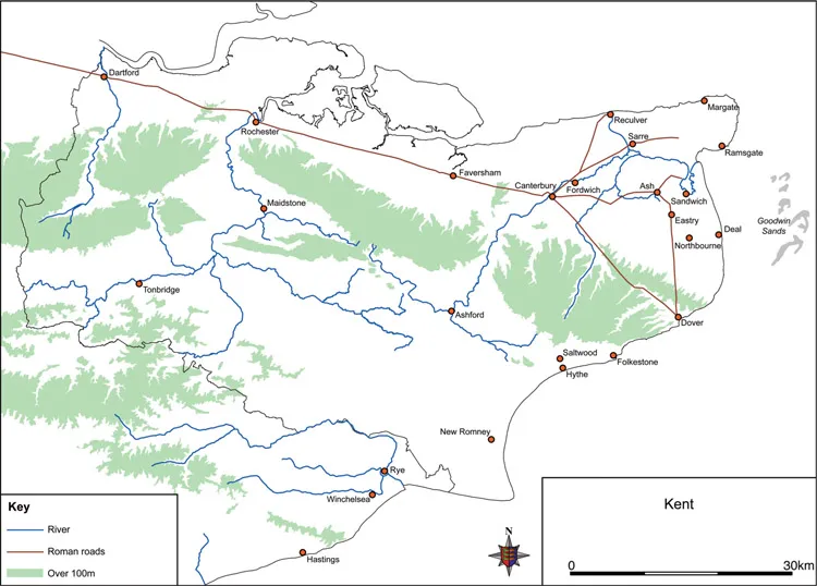
Fig. 1.1: Sandwich in east Kent, showing the main land route to London in both Roman and medieval times (B. C. & J. H.)
The approach has proved highly effective in throwing new light on Sandwich’s urban development through the formulation of hypotheses dependent on knowledge of the three disciplines. For example, archaeology has led to new theories on the siting of the original settlement and its subsequent growth; study of the surviving church architecture has provided crucial evidence for the early development of the present town; and investigation of the domestic buildings has revealed otherwise undocumented evidence of urban growth and decline, important not just for understanding Sandwich but also for the study of towns elsewhere. All this new information has been set against a new exploration of the archival sources, which has given insights into governance, trade, industry, society and fluctuations in the population – all evidence of the changing urban conditions, which have in large measure accounted for the patterns of survival on the ground.
At the outset it was decided to produce a single integrated text, not a series of parallel and mutually exclusive contributions by specialists in their own fields, and in the course of writing up the results it became clear that a multidisciplinary approach is not without its problems. Achieving a satisfactory fusion has proved extremely difficult and time-consuming, for different disciplines have their own ways of approaching and presenting information. The task of combining everything into a seamless whole has led to more rewriting than usual, and the publication presented here is the outcome of much cooperation and collaboration, as well as a test of the methodology involved.
1.2 The research area
The medieval town of Sandwich is well defined by its walls, and there is no evidence that the late medieval urban area ever spread beyond them. But before the fourteenth century the walls and ramparts did not exist, a fact that is sometimes forgotten, and the history of the wider area is critical to understanding the earlier period. Indeed, all three of the town’s parishes extend at least a small way beyond the walls, probably occupying the same ground as the south-eastern part of the hundred and Liberty of Sandwich (Figs 3.10, 5.4). These are medieval creations with no meaning for the very early history of the place, but their boundaries were fixed for sound historical reasons, and the study area has in large measure respected this wider region. The town within the walls has seen the most concentrated work during the project, but there have also been investigations further afield, in a block of about 4km2 as shown on Figure 1.5. Sandwich also had medieval and earlier connections with neighbouring settlements outside its immediate hinterland, as shown on Figure 2.1.
The urban area stands partly on an outcrop of Thanet Beds, creating a low ridge flanked by Alluvium on the north-west, north-east and south, and by Marine Sand on the east (Fig. 1.3). To the south and southwest, its hinterland is made up of gently undulating clay lands composed of Thanet Beds. The Sandowns lie to the east and the Lydden Valley to the south-east. The present landscape is the product of at least two millennia of change resulting from natural forces and human intervention, and its appearance is very different from that of the prehistoric and early historic periods.
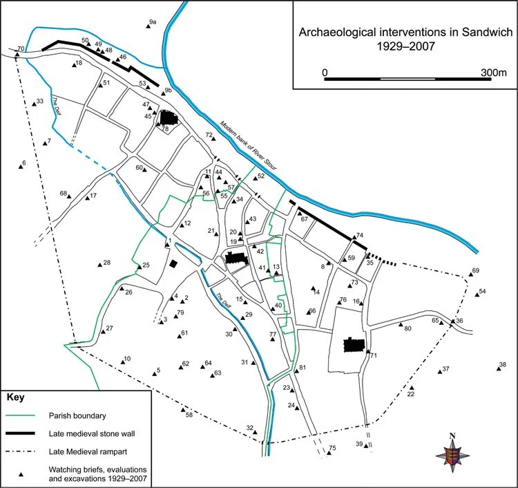
Fig. 1.2: Location map of archaeological interventions in Sandwich, 1929–2007. See Appendix 1 for explanation of numbers and details of sites (K. P., B. C. & J. H.). Reproduced by permission of Ordnance Survey on behalf of HMSO. © Crown copyright 2009. All rights reserved. Licence number 100046522
1.3 Methods
1.3.1 Archaeological methods
Sandwich’s status as a Conservation Area and the survival of so many fine medieval and early postmedieval structures, plus the absence of substantial urban regeneration, have provided few opportunities for modern archaeological excavation within the heart of the walled town, although during the years of the project there were a few small interventions routinely undertaken as part of the planning process (PPG 16). The constraints were not so severe in the hinterland of the town, and an extensive programme of test-pitting was carried out across the Sandowns to the east, largely by volunteers from the Dover Archaeological Group who also undertook field-walking and geophysical survey on Mary-le-Bone Hill (Chaps 2.3.4, 2.3.5).2 Ground surveys of the town and its hinterland resulted in close-contour maps of both areas, the interpretations of which are shown on Figures 1.3 and 1.5. Even taking account of the potential problems in matching modern contours with ancient land surfaces, the two surveys have greatly assisted in defining the local topography and in detailing areas of high and low ground, which reflect the underlying geology of Thanet Beds and Alluvium. They have been vital tools for the current project’s research into the topography and history of the town. In addition, a database of previous, often unpublished, archaeological interventions was compiled.
1.3.1.1 Database of archaeological sites (Fig. 1.2)3
The database consists of the details of seventy-four interventions known to have taken place within the walled town from 1929 to 2007 (Appendix 1). The information that can be culled from the interventions is extremely variable, with very little of it being of the standard expected today. Nevertheless, it was useful in supplementing other sources in testing the results of the contour surveys, and modifying the British Geological Survey map of 1988.
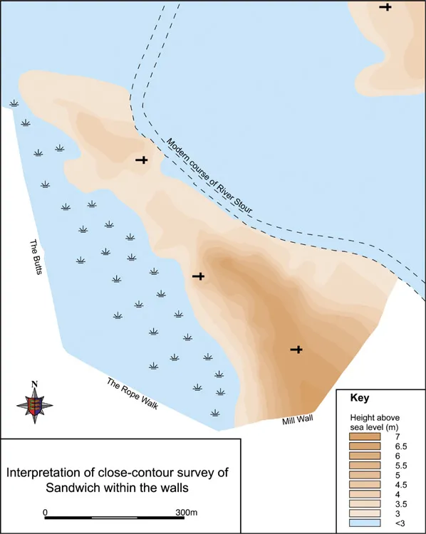
Fig. 1.3: Interpretation of the close-contour survey of Sandwich within the walls, contours at 0.50m intervals (K. P., B. C. & J. H.)
1.3.1.2 The close-contour survey of the town (Fig. 1.3) 4
The contour survey was conducted by a two-man team in 2003, just before the project officially began. The first task was to locate all the Ordnance Survey benchmarks on the modern 1:1250 OS map, some of which have been destroyed. For those that remained in situ, the distance to the adjacent ground surface was measured to give an initial set of precise levels around the town. Study revealed that OS spot heights shown along road lines were not always accurate, so they were generally ignored.
The survey was carried out using traditional means: a surveyor’s level and 5m staff. About 375 spot heights were taken along roads and paths and on accessible open ground and within the walled town. All readings were taken in metric and recorded to two decimal places, related to the nearest OS benchmark. Check measurements were taken regularly; errors of between 1cm and 5cm were deemed acceptable for the purposes of the survey. Contours were drawn by interpolation between the recorded spot heights, with a vertical interval of 50cm between them. Figure 1.3 shows the interpretation of the close-contour survey, emphasising the difference between the higher and lower areas of the town within the walls. This is also borne out by the distribution of archaeological sites where the type of subsoil could be established (Fig. 1.4).
1.3.1.3 The survey in the hinterland (Fig. 1.5) 5
During autumn and winter 2004 the same two-man team surveyed and mapped an area of 4km2, recording the contours at 1m intervals to produce a generalised picture of the overall configuration of the landscape. Using the same methods as before, approximately 730 spot-height readings were taken over as wide an area as possible, although some private land was inaccessible.
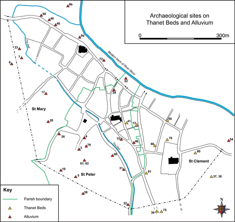
Fig. 1.4: The subsoil of archaeological sites in Sandwich (K. P., B. C. & J. H.). Reproduced by permission of Ordnance Survey on behalf of HMSO. © Crown copyright 2009. All rights reserved. Licence number 100046522
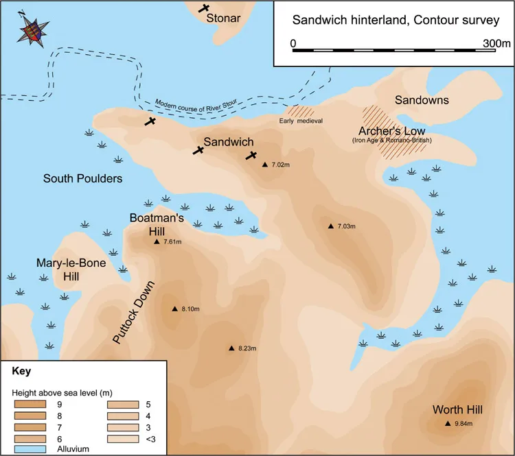
Fig. 1.5: Interpretation of the contour survey of Sandwich’s hinterland, contours at 1m intervals (K. P., B. C. & J. H.)
The suburban and rural landscape around Sandwich town displays many anomalies in its contours, deriving from sunken ways, terracing into slopes to create level building platforms and positive lynchets along the margins of fields. Where possible, readings were taken at representative points, ignoring local anomalies.
1.3.2 Topography/urban morphology
In a project in which new archaeological interventions were never going to play a large part, the study of topography took on a critical role, and the intimate relationship between the urban nucleus and its rural hinterland was appreciated from the start. In order to elucidate the changing topography, nineteenth-century Ordnance Survey maps were used to supplement the few earlier maps of the town and its surroundings (most of which appear in t...
Table of contents
- Cover
- Maps
- Title
- Copyright
- Contents
- Foreword
- Acknowledgements
- Summary
- Résumé
- Zusammenfassung
- List of Figures
- List of Tables
- Part I: Introduction
- Part II: Origins
- Part III: 1200–1360
- Part IV: 1360–1560
- Part V: 1560–1600
- Part VI: Conclusions
- Appendix 1: Sandwich archaeological sites, 1929–2007
- Appendix 2: Sandwich houses that appear on the maps
- Notes
- References and abbreviations
- Index
Frequently asked questions
Yes, you can cancel anytime from the Subscription tab in your account settings on the Perlego website. Your subscription will stay active until the end of your current billing period. Learn how to cancel your subscription
No, books cannot be downloaded as external files, such as PDFs, for use outside of Perlego. However, you can download books within the Perlego app for offline reading on mobile or tablet. Learn how to download books offline
Perlego offers two plans: Essential and Complete
- Essential is ideal for learners and professionals who enjoy exploring a wide range of subjects. Access the Essential Library with 800,000+ trusted titles and best-sellers across business, personal growth, and the humanities. Includes unlimited reading time and Standard Read Aloud voice.
- Complete: Perfect for advanced learners and researchers needing full, unrestricted access. Unlock 1.5M+ books across hundreds of subjects, including academic and specialized titles. The Complete Plan also includes advanced features like Premium Read Aloud and Research Assistant.
We are an online textbook subscription service, where you can get access to an entire online library for less than the price of a single book per month. With over 1.5 million books across 990+ topics, we’ve got you covered! Learn about our mission
Look out for the read-aloud symbol on your next book to see if you can listen to it. The read-aloud tool reads text aloud for you, highlighting the text as it is being read. You can pause it, speed it up and slow it down. Learn more about Read Aloud
Yes! You can use the Perlego app on both iOS and Android devices to read anytime, anywhere — even offline. Perfect for commutes or when you’re on the go.
Please note we cannot support devices running on iOS 13 and Android 7 or earlier. Learn more about using the app
Please note we cannot support devices running on iOS 13 and Android 7 or earlier. Learn more about using the app
Yes, you can access Sandwich - The 'Completest Medieval Town in England' by Helen Clarke, Sarah Pearson, Mavis E. Mate, Keith Parfitt, Sarah Pearson, Mavis E. Mate in PDF and/or ePUB format, as well as other popular books in History & European Medieval History. We have over 1.5 million books available in our catalogue for you to explore.