![]()
Chapter 1
Variable Decomposition
1.1. Typhoons in the Northwest Pacific and the South China Sea
A tropical cyclone is a rotating, organized system of clouds and thunderstorms that generates over tropical or subtropical oceanic basins and has a closed low-level circulation. Tropical cyclones rotate in a counterclockwise manner in the Northern Hemisphere (NH) and in a clockwise manner in the Southern Hemisphere (SH). They are classified as follows:
- Tropical Disturbance (TB): A TB with apparently organized convection (generally 100 to 300 miles in diameter) originates in the tropics or subtropics, with a non-frontal migratory character, and maintains its identity for 24 h or more.
- Tropical Depression (TD): A tropical cyclone with maximum sustained winds of 38 mph (33 knots or 17 m/s) or less.
- Tropical Storm (TS): A tropical cyclone with maximum sustained winds of 39 to 73 mph (34 to 63 knots or 18 to 32 m/s).
- Typhoon (TY) or Hurricane (HC): A tropical cyclone with maximum sustained winds of 74 mph (64 knots or 33 m/s) or higher. The terms “typhoon” and “hurricane” are used in the Northwest Pacific (NW Pacific or NWP) and the Atlantic Ocean, respectively. Similar storms in the Indian Ocean and South Pacific Ocean are called “tropical cyclones.”
- Super Typhoon (ST) or Major Hurricane (MH): A tropical cyclone with maximum sustained winds of 148 mph (129 knots or 67 m/s) or higher.
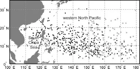
Most tropical cyclones form between 5º and 30º of latitude away from the equator in the NH (SH) and move typically westwards. Sometimes, the winds at the lower, middle and upper troposphere change and steer the cyclone toward the north and northwest in the NH and toward the south and southwest in the SH. When tropical cyclones reach latitudes near 30ºN in the NH, they often move northeastwards. Figure 1.1 shows 543TYs generated in the NW Pacific and in the South China Sea (SCS).
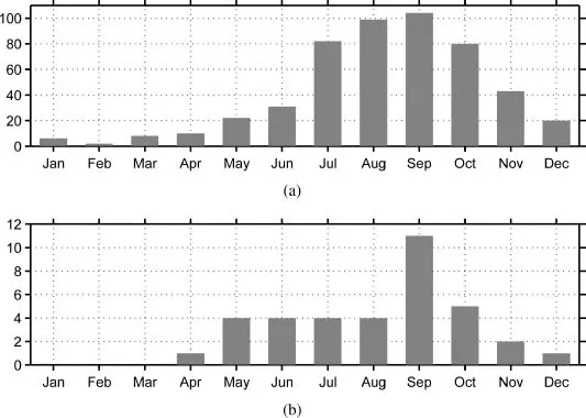
Seasonally, most typhoons form from May to December in the NW Pacific and from May to October in the SCS (Fig. 1.2). The maximum numbers of TYs in the NW Pacific and in the SCS are 104 and 11 in September, respectively. In the NW Pacific, TYs develop in all seasons. In contrast, no TYs occur in January, February, and March in the SCS.
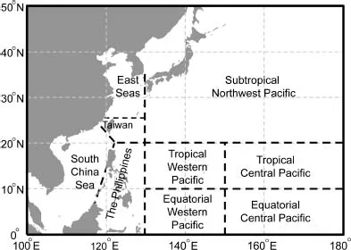
During the lifetime of a TY, there are locations of formation, peak intensity, and dissipation. To better describe the positions of generation and peak intensity, the following nine regions are shown in Fig. 1.3: (i) the east seas of China, (ii) the Taiwan area, (iii) the subtropical Northwest Pacific, (iv) the SCS, (v) the Philippines, (vi) the tropical western Pacific, (vii) the equatorial western Pacific, (viii) the tropical central Pacific, and (ix) the equatorial central Pacific. The east seas of China consist of the Bohai Sea, the Yellow Sea, the East China Sea, and the Taiwan area.
1.2. Decomposition Principles
Previous studies have shown that tropical cyclone motions are mainly governed by the tropospheric average steering flow (Chan and Gray 1982), generally defined as the vertical weighted average of the flow in the troposphere. During summer and autumn, tropical cyclones in the NWP generally move westwards, northwestwards, or northwards, mainly driven by large-scale steering flow associated with the dominant NWP subtropical high and westerly trough–ridge distribution. After passing the ridge line of the NWP subtropical high, tropical cyclones accelerate northeastwards owing to the influence of the large-scale westerly steering flow. Thus, most tropical cyclones moving westwards in the NWP would eventually turn northwards or northeastwards. This kind of track is designated as the recurvature (George and Gray 1977).
There were, however, some unusual tracks turning left and/or right for one or several times, but not following the large-scale steering flows. It is, thus, difficult to forecast whether, when, and where the turning motion occurs based on the traditional synoptic chart and the numerical weather forecast model products, because atmospheric variables include multiscale physical components and observational/model errors.
Some unusual motions of TYs were caused by the binary interaction with other tropical cyclones in the vicinity. The concept of binary interaction was well described by a Japanese meteorologist, named Fujiwhara (1921; 1931), in the early 20th century. This concept has now been referred to as the “Fujiwhara effect.” A previous study indicated that the Fujiwhara effect tends to be masked by environmental circulations (Willoughby 2007). Studies indicated that two tropical cyclones can interact with each other through approaching, merging, and escaping (Lander and Holland 1993). Specifically, Brand (1970) showed that two tropical cyclones begin to circle around each other when their distance is less than 750 nautical miles (nmi), and attract each other when their distance is less than 400 nmi.
Figure 1.1. Locations of 543 TYs generated in the period of 1979–2011. Among them, tracks of 330 TYs (solid dots) finally reached the north of 15ºN and the west of 130ºE during their lifetime.
Figure 1.2. The monthly number of TYs generated in (a) the NW Pacific and (b) the SCS in the period of 1979–2011.
Figure 1.3. Nine regions near the China coasts and in the NWP described in this atlas.
Most unusual tracks in this atlas are those of tropical cyclones that did not encounter other tropical cyclones in the vicinity but their turning motions cannot be explained by large-scale steering flows. In order to resolve this problem, we need to find another explanation.
Usually, total flows consist of several large-scale and small-scale circulation systems. These large-scale circulation systems are the steering flows that are associated with the inter-tropical convergence zone (ITCZ), subtropical highs, southwesterly monsoon flow, and westerly flow. Small-scale circulation systems include vortices in the upper and lower troposphere. Logically, large-scale steering flows provide a background of tropical cyclone motion, while the interaction can only be observed in small-scale circulation systems, such as two TY vortices and other vortices in the vicinity. Thus, extracting small-scale anomalous flow from total flow may be a possible method to examine this interaction and explain unusual tracks of TY motion (Qian et al. 2014).
Since TYs or tropical cyclones are embedded in the large-scale environmental flow, the decomposition of total or observed wind field is necessary. There are many mathematical decomposition methods based on orthogonal basis functions, such as spherical harmonic expansion globally and empirical orthogonal functions regionally. In a limited region, the harmonic-sine/cosine series expansion was used in decomposing and reconstructing wind field (Chen and Kuo 1992a; 1992b). The non-divergent and non-rotational wind components can be separated by using this method and used to describe the large-scale steering flow and the small-scale TY vortex, respectively. The spatial distributions of two components rely on the choice of domain. This decomposition method is independent of historical observations.
On the other hand, we introduce another decomposition method that relies on climatology. Traditionally, the climate is defined, to a large extent, as the average conditions over certain time intervals, such as monthly, seasonal, and annual averages (Peixoto and Oort 1992). In contrast to the method mentioned above, we decompose total flow (or other variables such as geopotential height and temperature) into four components as follows (Qian 2012c).
The term V(λ, φ, t)d,y on the lefthand side of Eq. (1) is the historical or current meteorological observations of wind vector V(λ, φ, t)d,y= iu(λ, φ, t)d,y + jv(λ, φ, t)d,y at a position of longitude λ and latitude φ, and at a diurnal time t (24 h a day), for example at 0000 or 0100 UTC Coordinated Universal Time (UTC) on a calendar date d in a year y.
The first component
on the righthand side of Eq. (1) is the zonal-averaged symmetric climate of wind from total
N years at a diurnal time
t on a calendar date
d. This component changes with latitude
φ and diurnal time
t in hours and calendar date
d, depending on the inclination of ...