![]()
Chapter 1
Automation and Mechatronics
![]()
Topography image segmentation based on multiphase level set method
Min-Rong Zhao
Natural Science College,
Air Force Engineering University,
Xi’an 710000, China
E-mail:[email protected] Xi-Wen Zhang
Information and Navigation College,
Air Force Engineering University,
Xi’an 710000, China
1. Introduction
The foundation for 3d landform reconstruction based on image is image segmentation the effect of the segmentation directly affect the accuracy of 3d reconstruction model. Identify the corresponding area of interested object that is image segmentation is the crucial step for reconstruction 3d object. Image segmentation plays an important role in the actual system such as in medical image processing, in order to rebuild the structure of an organ, the segmentation of the human CT scan image is needed[1]. In the remote sensing satellite image processing, in order to research the distribution of military target, the segmentation of the landform image is needed, the reconstruction of position model is based on landform image. Image segmentation is to separate different areas of the image has a special meaning and make the consistency of mutually disjoint areas, it is a classical problem of image processing and analysis.
2. A Level Set Method to Solve M-S Segmentation Model
Digital image has developed from 2d to 3d and from traditional gray level image to color image. At the same time, the traditional image processing techniques cannot meet the high demand, The shape change process cannot described in parameterized curve bight or hook face because of the landform complicated and the topological change of silhouette of key component is complexity and randomly
The image processing techniques based on partial differential equation excel in this respect, such as the traditional image edge detection method is difficult to realize 3d image segmentation, however, the mobile partition method of contour models based on the level set method is easier to do these. This way can handle the topological change very well, and divide the image which including many targets and extract the outline of targets[1,2], as shown in the Figure 1.
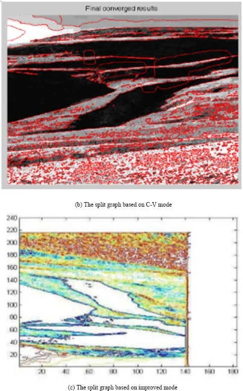
However, this way has a large calculation amount, a long sliced time, and even more serious for complex image, therefore, a new implementation model which increased the sliced speed of complex image in the way without requiring an initialization of signed distance function by introducing a new energy term was put forward, and the Chan-Vese mode was improved, so the iterations of segmentation was reduced, the sliced time was shortened, and the sliced speed was improved[3, 4], as shown in the Figure 2.
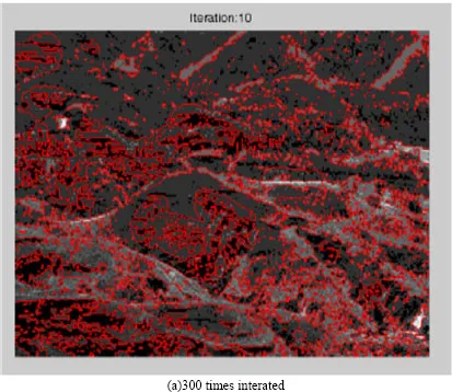
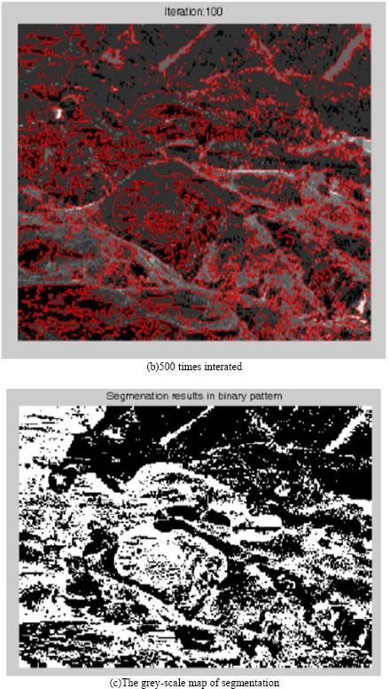
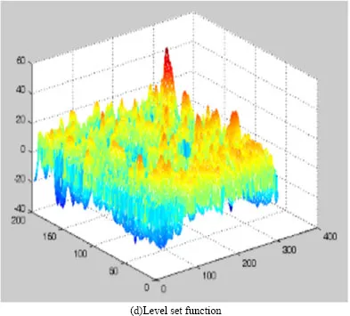
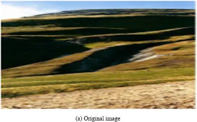
Figure1 is the sliced landform image experiment. Figure(a)(b)(c) is the 300 times interated, 500 times interated and the grey-scale map of segmentation. Figure(d) is the level set mode after stabilization. The results shows that the C-V mode can be used to slice landform image, but the sliced time is overlong or even several hours.
The sliced landform image based on improved C-V mode shows that the sliced time reduced because of the initialization was leaved out. The results shows that the choice of Δt in improved mode can larger than traditional level set mode. The evolution of level set can remain stable as long as μ·Δt <1/4s. Since a longer time step can be chosen, the iterations of segmentation is reduced, the sliced time is shortened and the sliced speed is improved.
All the results of the experiment show that the modified method not only improved the sliced speed but also improved the segmentation effect and stability. But the problem existing in reality is that the uneven strength of landform image result in difficult object extraction. In order to correct the segmentation method and achieve more desirable segmentation results, all kinds of model is put forward to solve the unavailability of C-V mode in uneven image management and achieve good results.
3. Landform Image Segmentation based on Polyphase Level Set Mode
3.1. Polyphase level set
The image is divided into two part in the C-V mode and modified mode and the research begins with the simplest dichotomous problem. However, the landform image consists of multiple target regions and deals principally with multi-objects image. In 2000, Chan and Vese provided a polyphase level set mode based on the Chan-Vese mode[5, 6], the basic idea of this new mode is used n Level Set functions to represent 2n different regions, it is Vese-Chan mode: two different region distinguished from ϕ can be expressed by a Level Set function, {ϕ > 0} and {ϕ < 0}; Two Level Set functions can distinguish four parts, such as {ϕ1 > 0, ϕ2 > 0}, {ϕ1 > 0, ϕ2 < 0}, {ϕ1 < 0, ϕ2 > 0}, and {ϕ1 < 0, ϕ2 < 0}. Three Level Set functions ϕ1, ϕ2, ϕ3 can distinguish eight parts, such as {ϕ1 > 0, ϕ2 > 0, ϕ3 > 0},...