Archaeological excavation during the construction of a new supply line for the electrification of the Great Western Railway Main Line uncovered part of a large, previously unknown Romano-British settlement along the main road between the Roman towns of Aquae Sulis and Cunetio. The full extent of the settlement is unknown but evidence from metal detector finds and field names suggests that it may have extended for at least 0.9 km along the Roman road.
- 120 pages
- English
- ePUB (mobile friendly)
- Available on iOS & Android
eBook - ePub
A Romano-British Roadside Settlement near Beanacre, Wiltshire
About this book
Trusted by 375,005 students
Access to over 1.5 million titles for a fair monthly price.
Study more efficiently using our study tools.
Information
Chapter 1
Introduction
The electrification of the Great Western Main Line railway from London to Bristol necessitated the installation of a twin 25KV power supply from National Grid’s Westlands Lane Substation (NGR ST 901000 708000) to a newly constructed Automatic Trackside Feeder Station at Thingley Rail Junction (NGR ST 896000 662000). Construction of the power line entailed stripping a 15−20 m wide easement along a 5.2 km corridor between the two substations (Fig. 1.1). Within this easement, cables were laid in two 3 m wide trenches, set either side of a 6 m wide haul road.
To mitigate the impact of the construction works on any buried archaeological remains, Wiltshire Council Archaeology Service (WCAS) requested that the stripping of topsoil and the initial excavations along the line of the cable trenches be monitored by means of an archaeological watching brief. The agreed methodology (Wessex Archaeology 2014a) stipulated that any archaeological remains uncovered during the monitoring would be excavated and recorded in advance of the construction work. WCAS also identified three areas of particular archaeological interest, where intensive monitoring was needed: Area 1 was focused either side of a Roman road that followed the boundary between Melksham Without and Lacock parishes, Area 2 was focused on a series of earthworks and cropmarks to the east of Wick Farm, near Lacock, Area 3 was located close to a group of cropmarks to the south of Thingley Junction. The archaeological fieldwork was undertaken between January and April 2015, and the post-excavation assessment produced later that year (Wessex Archaeology 2015a).
Topography and Geology
The cable route followed a generally north−south course through gently undulating farmland broadly parallel and immediately to the west of the Chippenham branch of the Wessex Main Line railway, and approximately 1 km to the west of the River Avon. Ground levels ranged between 43 m and 65 m above Ordnance Datum (OD). Area 1 was situated at the foot of a low hill on the western edge of the Avon floodplain. Here, the former Roman road crossed the easement at approximately 44 m OD. The land to the south of the Roman road sloped downhill slightly, whilst the land to the north sloped downhill towards a small unnamed stream at approximately 42 m OD.
The solid geology at the northern end of the cable route is Late Jurassic Limestone of the Cornbrash Formation, interspersed with bands of Mudstone of the Forest Marble Formation, and Sandstone, Siltstone and Mudstone of the Kellaways Formation. To the south of Area 2, the Cornbrash gives way to Late Jurassic Mudstone of the Oxford Clay Formation. The high ground to the west of the Avon valley is bisected by four small east−west tributaries of the main river, the largest of which, the Ladbrook, is flanked by superficial deposits of alluvium. There are also extensive river terrace deposits of sand and gravel towards the southern end of the cable route (British Geological Survey Online Viewer).
The gravel terraces flanking the River Avon have freely draining lime-rich loamy soils. Beyond the gravel terraces, the Avon Valley has slowly permeable, seasonally wet loamy and clayey soils. The limestone geology on the higher ground to the west of the Avon Valley gives rise to freely-draining shallow and lime-rich loamy soils, whilst the high areas with less-permeable geology have lime-rich loamy and clayey soils with impeded drainage. All of these soil types have historically been used for both arable and pasture, with some woodland in areas with poorer drainage.
Archaeological Background
Prehistoric
Neolithic, Bronze Age and Iron Age occupation sites have been uncovered in several locations to the southwest of Chippenham, notably on the gravel terraces near Showell Farm and Milbourne Farm (eg, Bateman and Enright 2000; Cotswold Archaeological Trust 1999; Cotswold Archaeology 2003; 2014; Oxford Archaeological Unit 1991). An assemblage of Neolithic pottery, Bronze Age spearheads and a dirk was also found during construction of the A350 bridge to the west of Melksham (McMahon 2004, 6). Between Melksham and Chippenham, the evidence for prehistoric activity is very sparse and largely restricted to isolated finds and diffuse scatters of Mesolithic and later worked flint, and there are no known prehistoric finds within 1 km of the cable route. However, this apparent paucity of prehistoric activity may simply reflect a lack of archaeological investigations beyond the areas affected by modern development.
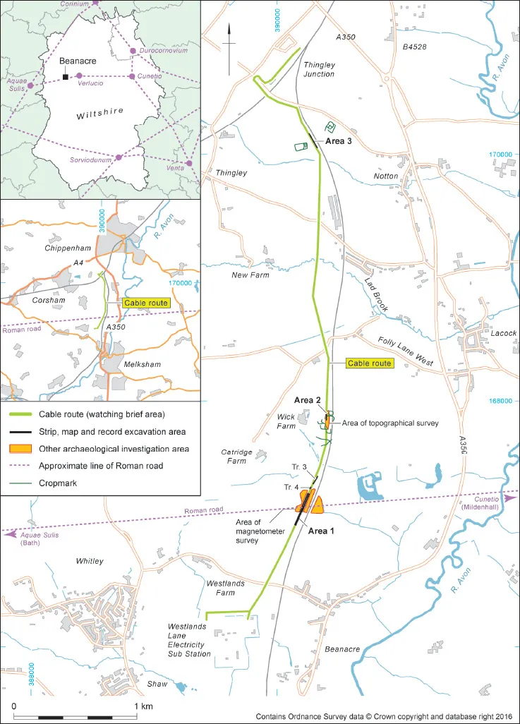
Figure 1.1 Site location, showing cable route and areas of archaeological investigation
There is widespread cropmark evidence for Bronze Age funerary monuments in the area, notably a probable barrow cemetery at Berryfield, to the south of Melksham. Probable barrows have also been identified at Lacock Abbey and near Shurnhold Farm and Frying Pan Farm, to the west of Melksham. There are a further three possible barrows at Thingley Farm and Thingley Junction, both within 150 m of the northern end of the cable route (Wiltshire Council 2018).
Romano-British
There is more evidence for Romano-British activity in the area, most notably a Roman road that crosses the cable route within Area 1. The Roman road linked settlements of Aquae Sulis (Bath) and Cunetio (Mildenhall), via the small town of Verlucio. The line of the Roman road is defined by extant field boundaries, earthworks and cropmarks, which are clearly visible for several kilometres to the east and west of the cable route. The Roman road crossed the River Avon 1.5 km to the east of the excavation area. Underwater archaeological investigations in this location uncovered substantial stone footings (CBA Wessex and CBA South West 1969, 49), which may be the remains of a bridge.
There are several known Roman rural settlements in the surrounding area (Fig. 1.2), including villas at Nuthills Farm (Marquess of Lansdown 1929), possibly Bromham (Oliver 1881) and Atworth (Shaw Mellor and Goodchild 1942; Erskine and Ellis 2008). Lower status farm sites have been identified at Showell Farm (Cotswold Archaeological Trust 1999; Young and Hancocks 2006), Milbourne Farm (Oxford Archaeological Unit 1991), Pockeridge Farm (Burn 1944; Wessex Archaeology 2000) and Bath Road, Melksham (Powell 2018). Nuthills Farm and Bromham villas are both located in the hinterland of Verlucio, approximately 6 km to the east of Area 1, whilst Atworth villa is situated to the south of the Roman road, 4.5 km west of the cable route. Showell Farm and Milborne Farm are both located on the gravel terrace overlooking the River Avon, 1 km to the east of Thingley Junction.
In addition to the known Romano-British settlement sites, the Wiltshire Historic Environment Record (WHER) and Portable Antiquities Scheme (PAS) record numerous finds of Roman material within 1 km of the cable route, many of which were found near Area 1.
Roman finds are particularly numerous in Lacock village and to the south of Folly Lane West, which suggests possible settlement activity in both locations. There are also concentrations of finds along the line of the Roman road, notably within a broad swathe that extends for up to 0.9 km to the east of Area 1. There is a further scatter of Roman finds 0.5 km to the west of Area 1, which may indicate the location of a separate settlement. Prior to the commencement of the archaeological work in 2015, a silver Roman finger-ring had been found within Area 1 (Hinds 2007). Finds from the fields to the east of Area 1 include Roman pottery and numerous coins (Ellis 2001) and a hoard of 93 late 3rd-century Barbarous Radiates (Ghey 2015). Most of the other coins from this area also date from the late 3rd or 4th century. Three Roman brooches and a bronze mount in the form of a human bust were recovered from the area to the east of the site. One of the brooches dates from the 1st century AD (Hinds 2008). Tellingly, perhaps, the coin hoard was found in a field named ‘Blacklands’ on the 1839 Melksham tithe apportionment. This name, probably derived from the colour of the soil, is frequently associated with Romano-British settlement sites (eg, Richardson 1996, 459; Wessex Archaeology 2007; Barber et al. 2013; Wilkinson 2013). Since 2015, there have been further finds of coins and metalwork, which are discussed by Henry in Chapter 3.
Saxon
There are no known Saxon remains in the immediate vicinity of the cable route. The villages of Lacock and Whitley are, however, both recorded in the Domesday Survey of AD 1086 (Williams and Martin 1992, 163, 177), which indicates that they were in existence by the late Saxon period. The Domesday Survey also records two mills in Corsham, both of which were probably situated near Thingley (Wiltshire Council 2011a). Extensive areas of woodland are also recorded in the manors of Lacock, Chippenham and Melksham (Darby and Welldon Finn 1967, 39; Williams and Martin 1992, 163, 177).
Medieval documents refer to part of the Roman road between Bath and western end of the East Wansdyke as the Wadensdich or Wodenes Ditch, which suggests that it was considered to be part of the early medieval boundary of the same name (Harvey 1998, 76−89; Grundy 1939, 576−9). The identification of the Roman road with the Wansdyke persisted into the post-medieval period and the name appears on a 1775 map of the Methuen Estate (Wiltshire Records Office 1742/8663).
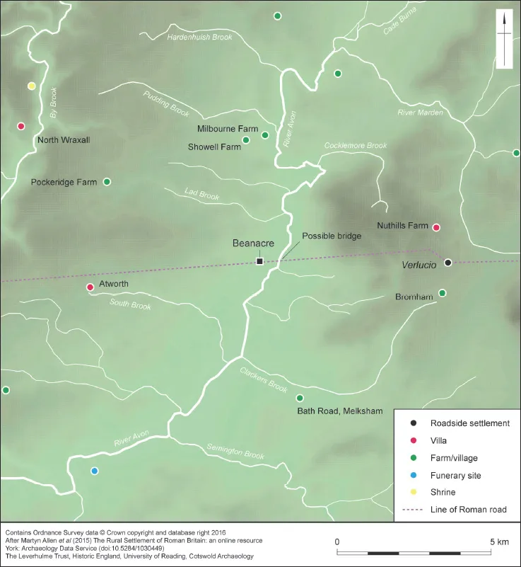
Figure 1.2 Location of the site in relation to selected nearby Romano-British settlements, villas and other sites
Medieval and Later
After the Norman Conquest, Lacock manor was granted to Edward of Salisbury and by the 13th century it was held by Ela, Countess of Salisbury. In 1229, Ela granted the manor to the church, and in 1232 she founded the Augustinian Nunnery of Lacock. The manor remained a monastic possession until the Dissolution. In 1540, the manor was purchased by William Sharington; it then passed by marriage to the Talbot family, who retained ownership of the estate until 1944 (Wiltshire Council 2011b).
Melksham manor was a royal possession from the late Saxon period to the 13th century. It was subsequently held by Amesbury Priory. From 1275 onwards, Melksham Beanacre is recorded as a separate manor, which was also held by Amesbury Priory. Melksham Beanacre was subsequently taken by the Crown, who sold it to the first of a succession of secular owners. In the late 17th century the manor was purchased by Paul Methuen, and it remained part of the Methuen estate until the 20th century (Chettle et al. 1953).
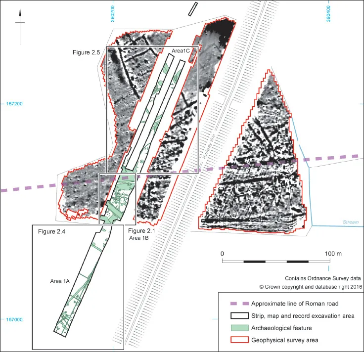
Figure 1.3 Archaeological features shown in relation to geophysical survey areas
There are no known medieval remains within the cable route. However, the nearby villages of Shaw, Beanacre and Thingley all have medieval origins (Chettle et al. 1953; Wiltshire Council 2011a), as do Wick Farm and Little Notton Farm (Gover et al. 1939, 104; Lake and Edwards 2014). Catridge Farm existed by the 16th century (Historic England 2017a), whilst Upper Beanacre Farm, Westlands (formerly West Knolls) Farm and New Farm all date from the 18th century (Historic England 2017b−d).
During the medieval period, large parts of Melksham and Chippenham manors lay within the royal forests of Pewsham and Melksham, much of which were wooded. There would also have been extensive areas of agricultural land, particularly around the villages and farms that are known to have existed during this period.
Two fields to the south and east of Wick Farm and Catridge Farm are identified on 1764 and 1841 maps as ‘The Grange’ and ‘Grange Mead’ (Wiltshire Records Office 2664/1/2E/19/L; T/A). This name could indicate the presence of a medieval monastic grange immediately to the west of the cable route. Indeed, there are a number of undated earthworks and cropmarks in this location, some of which extended into Area 2. These features are indicative of former hollow-ways, field boundaries or possibly more extensive settlement activity (Wessex Archaeology 2006, 11). The form of these features and their proximity to Wick Farm suggests that they are medieval.
The only significant modern development in the immediate vicinity of the cable route was the construction of the Great Western Railway Main Line in 1841 and the Wilts, Somerset and Weymouth Railway branch line in 1848 (Maggs 1982). Both lines remain in use.
The Site
Area 1
During the initial topsoil stripping, a large quantity of Romano-British pottery was found close to the line of the Roman road in Area 1. As a result, WCAS requested that a 100 m long section of the easement to the north and south of the Roman road be subject to a strip, map and record excavation. Once the subsoil had been stripped, it became clear that the course of the Roman road, which was most clearly defined by a (later) hollow-way, was flanked by a large, and previously unknown, Romano-British settlement that extended beyond the initial area of excavation in both directions. Thus WCAS asked that the area of investigation be enlarged to determine the extent of the settlement within the easement. This eventually entailed stripping a 277 m long by 15 m wide area, which was subsequently excavated under controlled archaeological conditions. The excavation area was subdivided into three ‘zones’ of activity: 1A, 1B and 1C (see Fig. 1.3), and investigated according to an agreed methodology (Wessex Archaeology 2014b). In order to determine the northern extent of the settlement a further two evaluation trenches, measuring 70 m by 2 m and 13 m by 2 m respectively, were excavated in the field immediately to the north of the main excavation area; these proved to be largely sterile and, therefore, no further work was undertaken in these locations. Wessex Archaeology also voluntarily undertook a geophysical survey of two fields adjacent to Area 1 (Fig. 1.3). The geophysical survey demonstrated that the exposed archaeological remains formed part of a larger settlement that extended for at least 200 m along the Roman road.
Area 2
Several undated (but possibly medieval) earthworks and cropmarks lay in this area, at least two of which extended into Area 2 (see Fig. 1.1). After the topsoil had been removed, a topographic survey was undertaken and two 24 m x 2 m evaluation trenches were excavated along the line of the western cable trench. No archaeological remains were found...
Table of contents
- Cover
- Title
- Copyright
- Contents
- List of Figures
- List of Plates
- List of Tables
- Acknowledgements
- Abstract
- Chapter 1: Introduction
- Chapter 2: The Excavations
- Chapter 3: Finds
- Chapter 4: Environmental Evidence
- Chapter 5: Discussion
- Bibliography
- Appendix 1: Local oxidised sandy ware fabrics Q100–Q105
Frequently asked questions
Yes, you can cancel anytime from the Subscription tab in your account settings on the Perlego website. Your subscription will stay active until the end of your current billing period. Learn how to cancel your subscription
No, books cannot be downloaded as external files, such as PDFs, for use outside of Perlego. However, you can download books within the Perlego app for offline reading on mobile or tablet. Learn how to download books offline
We are an online textbook subscription service, where you can get access to an entire online library for less than the price of a single book per month. With over 1.5 million books across 990+ topics, we’ve got you covered! Learn about our mission
Look out for the read-aloud symbol on your next book to see if you can listen to it. The read-aloud tool reads text aloud for you, highlighting the text as it is being read. You can pause it, speed it up and slow it down. Learn more about Read Aloud
Yes! You can use the Perlego app on both iOS and Android devices to read anytime, anywhere — even offline. Perfect for commutes or when you’re on the go.
Please note we cannot support devices running on iOS 13 and Android 7 or earlier. Learn more about using the app
Please note we cannot support devices running on iOS 13 and Android 7 or earlier. Learn more about using the app
Yes, you can access A Romano-British Roadside Settlement near Beanacre, Wiltshire by Cai Mason in PDF and/or ePUB format, as well as other popular books in History & Roman Ancient History. We have over 1.5 million books available in our catalogue for you to explore.