
eBook - ePub
Engaged Urbanism
Cities and Methodologies
- 304 pages
- English
- ePUB (mobile friendly)
- Available on iOS & Android
eBook - ePub
About this book
Engaged Urbanism showcases the exciting ways in which urbanists are responding to this question and working towards fairer cities. Its authors offer succinct, candid and carefully illustrated commentaries on the trials and successes of risk-taking research, revealing how they collaborate across fields of expertise, inventing or adapting methods to suit bespoke situations. Featuring novel uses and combinations of practice-from activism, architectural design and undercover journalism, to film, sculpture, performance and photography- in a diversity of cities such as Beirut, Johannesburg, Kisumu, London and Rio de Janeiro, Engaged Urbanism demonstrates how some of the greatest challenges for present and future populations are being rigorously and creatively addressed.
Trusted by 375,005 students
Access to over 1.5 million titles for a fair monthly price.
Study more efficiently using our study tools.
Information
IV
Situating Images and Imaginaries
12
THE UPS AND DOWNS OF VISUALISING CONTEMPORARY MUMBAI
Andrew Harris
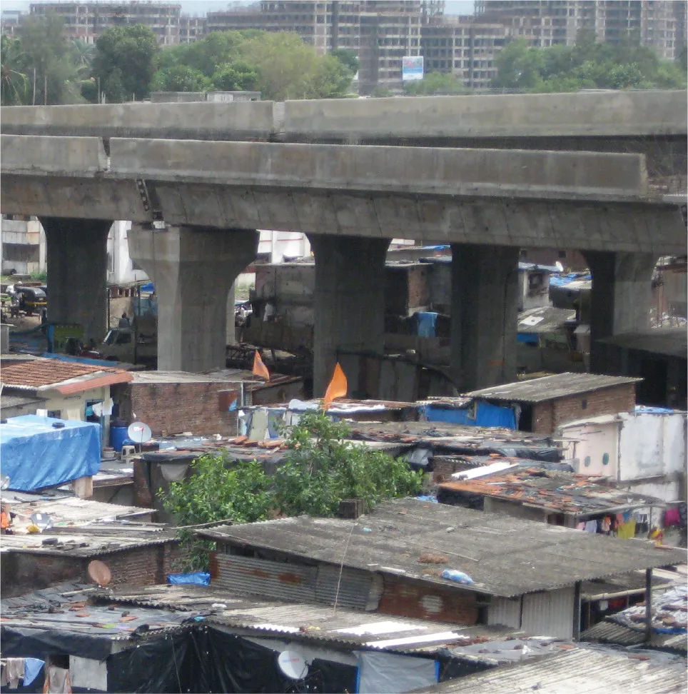
Since 2009, I have been investigating the construction of elevated roads (flyovers) and walkways (skywalks) in Mumbai. These have proliferated across the Mumbai Metropolitan Region since the mid-1990s, with over fifty flyovers built since 1998 and over thirty skywalks since 2008. My research uses these structures to explore new social and political relations in the city, ones that increasingly are framed and experienced through the vertical dimension.1 Despite their functionality and lack of obvious aesthetic appeal, flyovers and skywalks reveal important socio-spatial dimensions to recent elite efforts at remaking Mumbai as a ‘world-class’ Indian city. They are indicative of a new, selectively accessible, vertical layer across Mumbai over and above an increasingly crowded and congested metropolis.
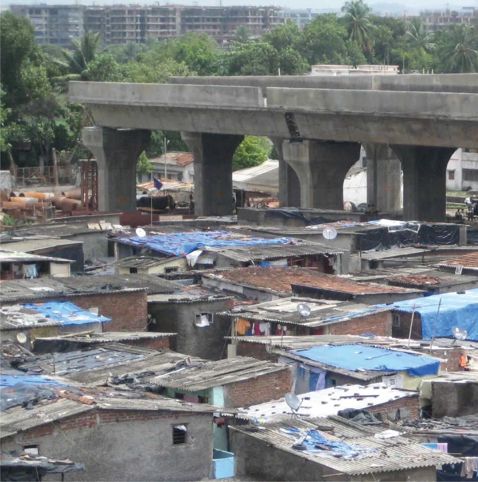
In order to assess the way in which these large pieces of Mumbai’s transport infrastructure operate and perform, I have sought documentation around their conception and reception, including planning reports, technical diagrams, newspapers articles and websites. I have also spoken to a range of key actors involved in the promotion, construction and maintenance of flyovers and skywalks: from engineers and planners to politicians, transport consultants and security guards. These archival and interview techniques have been supplemented and extended through visual methods and analysis. Although rarely matching the built reality of these schemes, tenders and promotional materials for flyover and skywalk projects show a city enjoying regulated traffic flows, slum-free residences and pristine engineering, where globally recognisable advertising images and logos are often prominent. I regularly came across these images as I encountered company websites, promotional videos, Powerpoint slides, scale models in foyers, screensavers and office walls. The construction of flyovers and skywalks accordingly need to be understood as part of a new visual regime shaping understandings of Mumbai’s urban futures.
Double-decker flyover at Kurla Terminus.

Scale model of flyover project.
I have also been keen to explore the visual life of flyovers and skywalks beyond these top-down, official visions. As I travelled around the city, I tried to develop a way of photographing different structures in a consistent fashion. This would involve shots of the ‘sweep’ of the flyover or skywalk along the road, photographs from centrally underneath, shots of columns or piers, signs and advertising, as well as activities beneath. This approach might be understood as a form of infrastructural flânerie that uses photography to reveal a ‘different nature’ to that of the naked eye.2 Using keywords in Adobe Lightroom to emphasise recurring categories across over 3,000 digital photos, I began to identify common features to what people did underneath (sleeping, selling, storing, playing) and how this everyday life underneath was regulated and controlled (fences, landscaping, sign-boards).3 In this way, I took advantage of how digital photography allows not only for large quantities of photographs to be taken but also for new ways of retrieving and cataloguing visual material. As William J. Mitchell presciently argued in 1992, the digital image ‘electronically accelerates the mechanisms of the visual record, enables the weaving of complex networks of interconnection between images to establish multiple and perhaps incommensurable layers of meaning’.4
FILMING JJ HOSPITAL FLYOVER
Although this style of photographic hyper-empiricism provided important insights into Mumbai’s infrastructural underworld, the digital camera’s fixed gaze did not sufficiently capture the important rhythms and flows that comprise these spaces. As well as still photos,
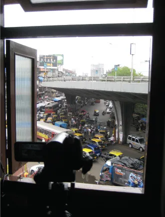
I experimented with video cameras to record flyover and skywalk scenes from a range of vantage points. These included the chaotic bustle (and occasionally surprising stillness) of the roads underneath or the steady processions of people or vehicles above, and I tried to find spots where I could record flows simultaneously above and below. Not only did my use of video indicate some of the variety of flyover and skywalk settings and experiences across Mumbai, it emphasised how these structures create and constitute a two-tiered city. Whereas traffic on flyovers would stream smoothly and regularly along these elevated routes, the streets below were filled with an unpredictable and stop-start array of pedestrians, hawkers, trucks, carts and buses negotiating their way ahead, frequently disrupted and frustrated by policemen, animals, traffic lights and pot-holes. As cars forced their way through this erratic choreography, the main rationale behind constructing skywalks (rechannelling non-vehicular traffic upwards) became clear. These vertical differences were something I sought to exploit in the arrangement of digital photos (single shots and sequences) and videos (complete with soundtrack) of the JJ Hospital flyover for my Cities Methodologies installation in 2010. Taking advantage of the high walls of the Slade Research Centre at UCL, these were organised systematically so that ground-level images were presented by the floor whereas a photograph looking down on the flyover was towards the ceiling (and less accessible to the viewer).
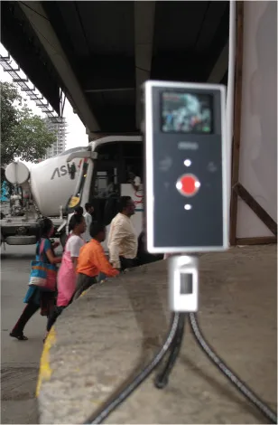
Flip camera, Senapati Bapat Marg, Tulsi Pipe Road.
Filming above and below the JJ Hospital Flyover.
Although my photography and video footage importantly revealed some three-dimensional relations of power carved through contemporary Mumbai by flyovers and skywalks, I was aware that this remained an interpretation framed through my own assumptions, as well as the decisions I had made of what to shoot and where to shoot it (and how to display it). I was struck by how people who saw me with my camera in Mumbai would often assume I would prefer to film from raised positions, such as the roof of a building in Kurla looking across at India’s first double-decker flyover under construction. Working with colleagues to film underneath the long JJ Hospital flyover that runs down Mohammed Ali Road in central Mumbai, we managed to negotiate to shoot from an elevated post used by the police.5 This process emphasised how the ability and opportunity to visually capture these spaces inevitably was bound up with a position of power, especially in a predominately Muslim neighbourhood such as this with colonial and post-colonial histories of surveillance.
In order to disrupt straightforward assumptions being drawn and unreflexive positions being taken in a visual ‘audit’, this project emphasised the need to combine visual methods with the ethnographic focus of my research. As Mumbai’s global profile has grown over the past decade, there has been a tendency to rely on a shorthand set of key visual images to represent and understand the city.6 A good example is the large water pipes that pass through a large ‘informal’ settlement called Dharavi, which have featured in an iconic photo by Sebastião Salgado and director Danny Boyle’s film, Slumdog Millionaire.7 Although the use of this image importantly captures a scene displaying modern infrastructural provision yet limited accessibility for those people featured, there is rarely much more detail around the thoughts and experiences of those shown. In my flyover and skywalk research, I wanted to ensure I had some idea of what the people who lived and worked underneath actually made of these structures. Informal conversations revealed that many people, even those without access to flyovers as they did not own a private vehicle, actually quite liked the way these large structures provided shade from the sun and shelter during the monsoons and often saw them as vindications of Mumbai’s modern progress. Future work might try not only to talk to those underneath but to collaborate with them to photograph or film (and discuss) how they understand and experience these spaces.
Another aspect to unsettling the analytical scope of visual methods in this research was to find ways of acknowledging the opaque qualities of everyday life in Mumbai. In many respects, the city thrives on its unknowability, and, indeed, I struggled to find certain planning reports despite persistent attempts at locating them. Thus, in presenting material visually, I tried to develop outputs that were deliberately fragmentary and could be understood as strategically incomplete. The project website presents photographs, film clips, sound recordings and newspaper and interview quotes without clear statements about what they necessarily represent.8 The website was also deliberately created before I subsequently wrote up material in academic papers so that it became part of the process of the research rather than simply a final outcome. Although the material is categorised in both English and Hindi (from Lightroom tags and transcript coding) and located on a map, there is limited guiding narrative and explanation of categories. Visitors to the site have to reach their own judgements (in a manner similar to myself) as they navigate the material, and there is a facility to submit their own opinions and thoughts. Investigating an array of visual components to contemporary Mumbai may be an essential feature of understanding the social and political dynamics of this city, but it is also crucial to question how this visual material is interpreted and re-presented.
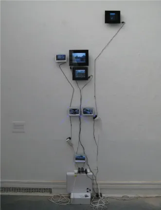
Vertical Urbanism exhibit, Cities Methodologies, 2010.

Filming from police platform, Mohammed Ali Road.
1See Andrew Harris, ‘Vertical Urbanism: Flyovers and Skywalks in Mumbai’, in Urban Constellations, edited by Matthew Gandy (Berlin: Jovis, 2011), 118 – 23; Andrew Harris, ‘Concrete Geographies: Assembling Global Mumbai through Transport Infrastructure’, City, 17 (3) (2013): 343–60. This project was funded by the ESRC (Award RES-000-22-3127).
2As Walter Benjamin argues, a camera enhances the practice of flânerie ‘by focusing on hidden details of familiar objects’ such that ‘a different nature opens itself to the camera than opens to the naked eye’. Walter Benjamin, Illuminations (London: Pimlico, 1999), 229 –30.
3See my photo-essay, ‘Mumbai’s Underworld: Life Beneath Transport Infrastructure’, Moving Worlds, 13 (2) (2013): 151–60.
4William J. Mitchell, The Reconfigured Eye:Visual Truth in the Post-Photographic Era (Cambridge, MA: MIT Press, 1992), 85.
5My thanks to Savitri Medhatul and Rahul Dandekar.
6Andrew Harris, ‘The Metonymic Urbanism of Twenty-First-Century Mumbai’, Urban Studies, 49 (13) (2012): 2955 –73.
7See also the discussion on page 2 of Stephen Graham and Simon Marvin’s Splintering Urbanism: Networked Infrastructures, Technological Mobilities and the Urban Condition (London: Routledge, 2001).
8http://www.verticalurbanism.com (created with the assistance of Sanjay Bhangar from CAMP).
13
CREATING SYSTEMATIC RECORDS THROUGH TIME
The destruction ...
Table of contents
- Cover
- Title Page
- Contents
- Preface and acknowledgements
- Engaged urbanism: situated and experimental methodologies for fairer cities Ben Campkin and Ger Duijzings
- I: Frames
- II: Site-Specific Collaborations
- III: Performance and Participation
- IV: Situating Images and Imaginaries
- V: Embodied Cartographies
- VI: Fabric and Fabrication
- Contributors
- Copyright
Frequently asked questions
Yes, you can cancel anytime from the Subscription tab in your account settings on the Perlego website. Your subscription will stay active until the end of your current billing period. Learn how to cancel your subscription
No, books cannot be downloaded as external files, such as PDFs, for use outside of Perlego. However, you can download books within the Perlego app for offline reading on mobile or tablet. Learn how to download books offline
Perlego offers two plans: Essential and Complete
- Essential is ideal for learners and professionals who enjoy exploring a wide range of subjects. Access the Essential Library with 800,000+ trusted titles and best-sellers across business, personal growth, and the humanities. Includes unlimited reading time and Standard Read Aloud voice.
- Complete: Perfect for advanced learners and researchers needing full, unrestricted access. Unlock 1.5M+ books across hundreds of subjects, including academic and specialized titles. The Complete Plan also includes advanced features like Premium Read Aloud and Research Assistant.
We are an online textbook subscription service, where you can get access to an entire online library for less than the price of a single book per month. With over 1.5 million books across 990+ topics, we’ve got you covered! Learn about our mission
Look out for the read-aloud symbol on your next book to see if you can listen to it. The read-aloud tool reads text aloud for you, highlighting the text as it is being read. You can pause it, speed it up and slow it down. Learn more about Read Aloud
Yes! You can use the Perlego app on both iOS and Android devices to read anytime, anywhere — even offline. Perfect for commutes or when you’re on the go.
Please note we cannot support devices running on iOS 13 and Android 7 or earlier. Learn more about using the app
Please note we cannot support devices running on iOS 13 and Android 7 or earlier. Learn more about using the app
Yes, you can access Engaged Urbanism by Ben Campkin, Ger Duijzings, Ben Campkin,Ger Duijzings in PDF and/or ePUB format, as well as other popular books in Social Sciences & Architecture Criticism. We have over 1.5 million books available in our catalogue for you to explore.