Winner of the Penang Book Prize 2019
Nusantaria – often referred to as 'Maritime Southeast Asia' – is the world's largest archipelago and has, for centuries, been a vital cultural and trading hub. Nusantara, a Sanskrit, then Malay, word referring to an island realm, is here adapted to become Nusantaria - denoting a slightly wider world but one with a single linguistic, cultural and trading base. Nusantaria encompasses the lands and shores created by the melting of the ice following the last Ice Age. These have long been primarily the domain of the Austronesian-speaking peoples and their seafaring traditions. The surrounding waters have always been uniquely important as a corridor connecting East Asia to India, the Middle East, Europe and Africa. In this book, Philip Bowring provides a history of the world's largest and most important archipelago and its adjacent coasts. He tells the story of the peoples and lands located at this crucial maritime and cultural crossroads, from its birth following the last Ice Age to today.
- 336 pages
- English
- ePUB (mobile friendly)
- Available on iOS & Android
eBook - ePub
About this book
Trusted by 375,005 students
Access to over 1.5 million titles for a fair monthly price.
Study more efficiently using our study tools.
Information
Chapter 1
Child of a Drowned Parent

Physical Geography
Nusantaria is a relatively new creation. Figure 1 is a map of South East Asia approximately 17,000 years ago. There is no Java Sea nor Melaka strait; the South China Sea is much smaller than today; Sumatra, Java, Taiwan and Hainan are not islands.1 Even by the standards of humans, 17,000 years is not so very long ago considering that modern man reached New Guinea and Australia 50,000 years ago. A huge rise in sea level between 20,000 bp and 7000 bp flooded a large part of the Sunda Shelf, which had been, prior to that rise, part of the Asian mainland. A more modest rise continued till about 4000 bp, then a small decline gave back some land. Since then the general sea level has been, until very recently, relatively steady for the past 1,000 years.
The years of rising seas also flooded some of the Sahul Shelf, of which New Guinea and Australia are the main components. Of present day South East Asia, only the Philippines (except Palawan), Sulawesi and the eastern Indonesian islands were separate from either shelf. One exception was Sumba, a mainly sandstone island which had once been part of either Sundaland or Sahuland but drifted off.2 The other islands of that intermediate region, now named ‘Wallacea’ after the nineteenth-century naturalist Alfred Russell Wallace, are volcanic.3
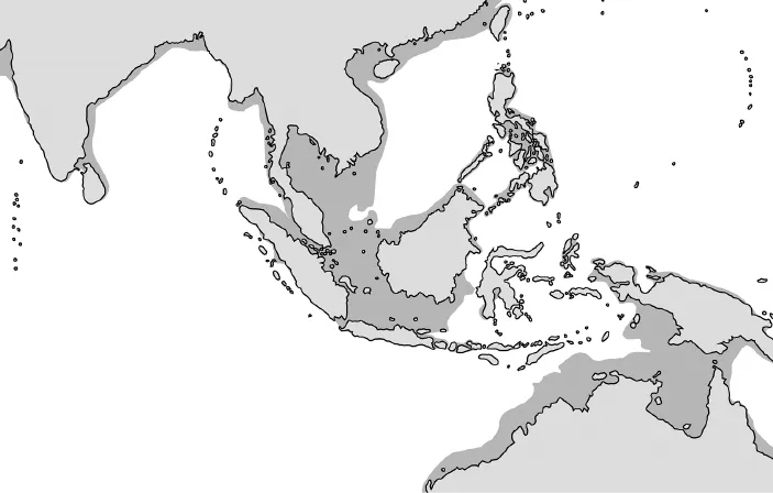
Map 1. Land at 15,000 BP.
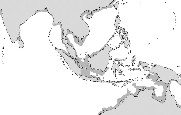
Map 2. Land at 11,000 BP.
Going back further in time, much of the South East Asian landmass was originally formed when, millions of years ago, parts of the ancient vast southern continent of Gondwanaland broke off and moved north. Some joined the northern continent, which has been named Laurasia and now forms the Indian subcontinent and parts of mainland South East Asia.
These landmass movements continue, affecting daily life today, as well as determining development measured in millions of years. Sumatra, Java and most of the islands of eastern Indonesia sit just north of a massive fault line as the Australian plate pushes north. This makes the archipelago the most earthquake- and volcano-prone place in the world. To the north-east is another fault line where the Indian plate meets the Philippine plate. The Philippine islands, except Palawan, are on their own plate, possibly having once been part of a larger one that has been much altered since by volcanic eruptions.
The last ice age peak was about 22,000 years ago, but modern man and his predecessors had been living with huge climate shifts for much longer. The changes in temperature and the coming and going of the sea played a critical part in the much earlier history of humans in this region, including Homo Erectus and Neanderthal man. The discovery of so-called Java Man in 1891 was the first of several finds of Homo Erectus on Java between 1 million and 600,000 years ago. Sangiran near Solo in central Java has yielded one of the largest collection of Homo Erectus remains in the world and provided important evidence of man’s evolutionary progress.
There was not just one great ice age. Over the past 250,000 years there have been several periods of a warmer planet and higher seas, but the average sea level over the period was about 40 metres below that of today. At the peak of the last ice age, around 21,000 bp, the Eurasian landmass almost reached Australia. At that low point – a sea level of about 120 metres below today – some three million square kilometres of what is now sea were dry land with plains, hills and river systems. The Japanese islands were joined up; Kyushu was linked to what is now the Korean peninsula and to Taiwan via the Ryukyu islands.4 After that, the rate of sea level rise varied enormously: about 80 metres of the rise occurred in just 7,000 years. Around 14,000 bp it rose five metres in 100 years – compare this with a recent rate of about 20 centimetres per 100 years. Around 11,000 bp the level was 50 metres below the current level. At that time mainland Asia was still joined to Sumatra, Java, Borneo and Hainan and Taiwan. The rise between 11,000 and 7000 bp, after which sea levels became relatively stable, defined today’s maritime region centred on the drowned Sunda Shelf.5
It is becoming clearer from the study of seabeds that the defining event in creating Nusantaria, the flood, was not a gradual process of a centimetre a decade. There is evidence of sudden increases driven by the collapse of ice fields and changes in pressures on the earth’s crust creating earthquakes and tsunamis. Such sudden changes probably explain the Biblical flood ‘myth’ found in many cultures.6
Even at the lowest sea levels of the last ice age, there was deep water between Bali on the edge of the Sunda Shelf and the Sahul Shelf. But the distances were small enough for humans – though not for many animal species – to cross. It was during the last great glaciations that modern humans reached Australia, most likely arriving via Wallacea. New Guinea was reached about the same time and became, around ten thousand years ago, probably the first place on earth – long before Egypt or Mesopotamia – where settled agriculture was practised.
Human Geography, or BioGeography
The sea rise also created a genetic and cultural rift. By modern times there was a clear racial divide between the Malay-Polynesians, speaking Austronesian languages, and Papuan-Melanesian physical types and cultures. Despite their remarkable east to west dispersal, the former left little trace in lands that were relics of the Sahul Shelf other than in the Bismarck Archipelago. However, some Melanesians remained further west. Findings from Niah cave in Sarawak dated to about 40,000 years ago and at Tabon on Palawan dated to 25,000 years ago have genetic characteristics similar to ancient Australians and Melanesians.7 So it is likely that the first Homo Sapiens in the region were of the same stock as the Australo-Melanesians who settled the forests and highland valleys of New Guinea and the bush country and great deserts of Australia. The Tabon caves were inhabited from around 30,000 bp, but while they now overlook the sea they were once on a hillside far from the shore. Thus far, no similar finds have been made on other islands, which may suggest that Tabon man walked there and that early man in that region had yet to gain sufficient skills to cross from Palawan to Mindanao or the Visayas.
The deep water gaps between Wallacea and the Sahul and Sunda landmasses had a huge impact on fauna and flora. Until later introduced by humans, large placental mammals never crossed that divide from Sundaland to Wallacea nor did large marsupials move in the other direction. Wallacea had its own separate but rather limited indigenous fauna and flora due to its weak links to the great landmasses and the distance in time since it had drifted from Gondwanaland.
The ending of the last ice age must have been a catastrophe for many of the people of Sundaland, the relatively flat land between what is now the Asian mainland and the coasts of Sumatra, Java and Borneo. While global warming enabled areas such as northern Europe to become habitable, in Asia it destroyed large numbers of human settlements in a region which previously should have been very conducive to habitation. By the same token, the creation of many islands and a huge expansion of coastlines produced the environment for the world of the Nusantarians, living on and by the sea, developing sailing craft and navigational prowess and building the coastal exchange networks which eventually evolved into ocean-spanning movements. They were behind the expansion of human settlement and of trade around half the globe. The same people, originating from Nusantaria, settled almost every island between Rapa Nui (Easter Island) and Madagascar, between Taiwan and New Zealand.
Today, the majority of people from Nusantaria are defined as ‘Austronesians’ – a Greek-derived word meaning ‘southern islands’ but now applied to a language group. Austronesian is in the first instance a linguistic marker though also with shared genetic and cultural...
Table of contents
- Contents
- List of Maps and Illustrations
- Glossary
- Preface
- Introduction
- Chapter 1 • Child of a Drowned Parent
- Chapter 2 • Nusantaria’s Defining Features and Early People
- Chapter 3 • To Babylon and Back
- Chapter 4 • Ghosts of Early Empires
- Chapter 5 • Culture from India, Goods from China
- Chapter 6 • Srivijaya: Vanished Great Mandala
- Chapter 7 • Java Takes Centre Stage
- Chapter 8 • Tamil Tigers of Trade
- Chapter 9 • Champa: Master of the East Sea
- Chapter 10 • Malagasy Genes and African Echoes
- Chapter 11 • China Raises Its Head
- Chapter 12 • The Majapahit Good Life
- Chapter 13 • Tremble and Obey: The Zheng He Voyages
- Chapter 14 • Nails, Dowels and Improbable Ships
- Chapter 15 • Malay Melaka’s Lasting Legacy
- Chapter 16 • The Northern Outliers
- Chapter 17 • Islam’s Great Leap East
- Chapter 18 • Nusantaria: Holed Near the Waterline
- Chapter 19 • Barangays and Baybayin
- Chapter 20 • Makassar, Bugis and Freedom of the Seas
- Chapter 21 • Where Kings Reign but Priests Rule
- Chapter 22 • The Sulu Factor: Trading, Raiding, Slaving
- Chapter 23 • Nusantaria’s Existential Crisis
- Chapter 24 • Labour, Capital and Kongsi: The Power of the Chinese
- Chapter 25 • High Noon of Occupation
- Chapter 26 • Empty Lands No Longer
- Chapter 27 • Freedom, Fears and the Future
- Notes
- Bibliography
- Colour Plates
- Black-and-White Plates
Frequently asked questions
Yes, you can cancel anytime from the Subscription tab in your account settings on the Perlego website. Your subscription will stay active until the end of your current billing period. Learn how to cancel your subscription
No, books cannot be downloaded as external files, such as PDFs, for use outside of Perlego. However, you can download books within the Perlego app for offline reading on mobile or tablet. Learn how to download books offline
Perlego offers two plans: Essential and Complete
- Essential is ideal for learners and professionals who enjoy exploring a wide range of subjects. Access the Essential Library with 800,000+ trusted titles and best-sellers across business, personal growth, and the humanities. Includes unlimited reading time and Standard Read Aloud voice.
- Complete: Perfect for advanced learners and researchers needing full, unrestricted access. Unlock 1.5M+ books across hundreds of subjects, including academic and specialized titles. The Complete Plan also includes advanced features like Premium Read Aloud and Research Assistant.
We are an online textbook subscription service, where you can get access to an entire online library for less than the price of a single book per month. With over 1.5 million books across 990+ topics, we’ve got you covered! Learn about our mission
Look out for the read-aloud symbol on your next book to see if you can listen to it. The read-aloud tool reads text aloud for you, highlighting the text as it is being read. You can pause it, speed it up and slow it down. Learn more about Read Aloud
Yes! You can use the Perlego app on both iOS and Android devices to read anytime, anywhere — even offline. Perfect for commutes or when you’re on the go.
Please note we cannot support devices running on iOS 13 and Android 7 or earlier. Learn more about using the app
Please note we cannot support devices running on iOS 13 and Android 7 or earlier. Learn more about using the app
Yes, you can access Empire of the Winds by Philip Bowring in PDF and/or ePUB format, as well as other popular books in History & Economic History. We have over 1.5 million books available in our catalogue for you to explore.