Throughout history, every power that has aspired to dominate the Balkans, a crucial crossroads between Europe, Asia, and Africa, has sought to control Macedonia. But although Macedonia has figured prominently in history, its name was largely absent from the historical stage, representing only a disputed territory of indeterminate boundaries, until the nineteenth century. Successive invaders— Roman, Gothic, Hun, Slav, Ottoman— passed through or subjugated the area and incorporated it into their respective dynastic or territorial empires. This detailed volume surveys the history of Macedonia from 600 BC to the present day, with an emphasis on the past two centuries. It reveals how the "Macedonian question" has long dominated Balkan politics and how, for nearly two centuries, it was the central issue dividing Balkan peoples, as neighboring nations struggled for possession of Macedonia and denied any distinct Macedonian identity— territorial, political, ethnic, or national. The author concludes that Balkan acceptance of a Macedonian identity, nation, and state has become a necessity for stability in the Balkans and in a united Europe.
Trusted by 375,005 students
Access to over 1.5 million titles for a fair monthly price.
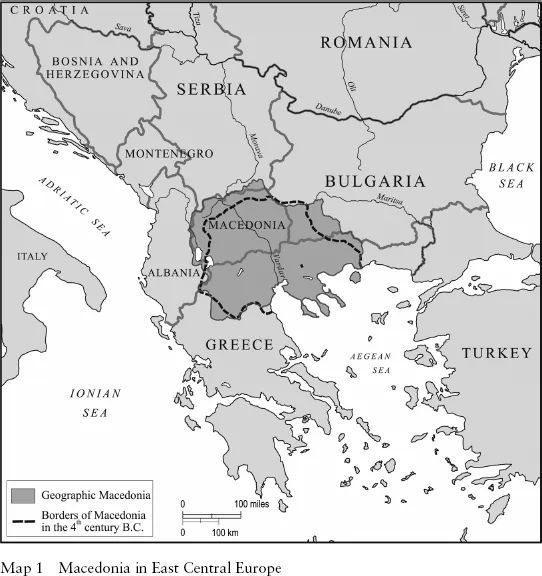
Macedonia is in the central part of the Balkan Peninsula. Its geographical boundaries have varied with time, but since the nineteenth century, when the "thorny" Macedonian question began to obsess the new Balkan states, Greece, Serbia, and Bulgaria, and the chancelleries of the great powers of Europe, they have been clear and have received general recognition.
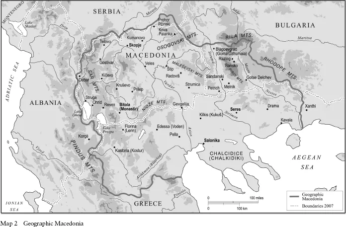
Geographic Macedonia's border consists of the mountains of Šar Planina, Skopska Crna Gora, Kozjak, Osogovo, and Rila to the north; the western slopes of Rhodope upland and the lower Mesta (Nestos) River to the east; the Aegean Sea and the Aliakmon (Bistrica) River to the south; and the Gramos massif, Lake Prespa, and Lake Ohrid, and the Korab and Jablonica range, to the west, toward Albania. Macedonia covers about 67,741 square kilometers, or about 15 percent of the Balkan Peninsula.
Throughout recorded history, Macedonia has been a strategic and economic crossroads. The Vardar-Morava valley forms the most direct and most natural highway and corridor-route from central Europe to the Mediterranean and to the Near East and the Suez Canal. Macedonia also controls the best approaches to the Drin valley routes leading to the Adriatic Sea. The Via Egnatia—the shortest Roman-era cross-Balkan
route from Durrës (Durazzo, Dra
) on the Adriatic to the Bosphorus—passed through Ohrid, Bitola (Monastir), and Salonika (Thessaloniki) on the way to Constantinople (Istanbul). Finally, the imperial powers in Constantinople/Istanbul could reach their possessions further afield in Greece, Albania, Serbia, Bosnia, and elsewhere only through Macedonia.
The Balkan Wars of 1912–13, particularly the Second Balkan, or Inter-Allied War, led to the first violation of Macedonia's territorial integrity since dynastic states fought each other in the medieval Balkans and the Ottoman empire conquered the region in the late fourteenth and early fifteenth centuries. In 1913, force of arms partitioned Macedonia between the kingdom of Bulgaria and the allied kingdoms of Greece and Serbia. This arrangement, with minor modifications, survives to this day.
Serbia—“Yugoslavia” after the Great War—took Vardar Macedonia, about 25,775 square kilometers. After 1945, as the People's Federal Republic of Macedonia and, after 1971, as the Socialist Federal Republic of Macedonia, that region formed one of six republics of the Communist-led federal Yugoslavia. Following the violent collapse of the federation, it proclaimed its complete sovereignty and independence as the republic of Macedonia in 1991.
In 1913, Greece acquired Aegean Macedonia, at about 34,000 square kilometers the largest piece of Macedonian territory. Bulgaria took the smallest part, Pirin Macedonia, with about 6,778 square kilometers. Albania, a state that the great powers created in 1912, received the relatively small areas of Mala Prespa and Golo Brdo. Albania, Bulgaria, and Greece have completely absorbed their portions, not recognizing them even as distinctive, let alone autonomous.
In geographic Macedonia, large and high mountain ranges give way to wide, flat valleys and plains. Deep ravines and lakes—Ohrid, Prespa, Dojran, Besik, and Lagodin—interconnect the valleys. Vardar Macedonia is largely a plateau lying from 2,000 feet to 8,000 feet (610 meters to 915 meters) above sea level, with mountains (Jakupica) reaching 8,331 feet (2,541 meters). The main valleys are those of the Vardar, the lower Bregalnica, and the lower Crna rivers. The Kožuf and the Nidže ranges, with Mt Kajmak
alan as the highest peak (8,271 feet, or 2,526 meters), divide Vardar from its southern neighbor, Aegean Macedonia. In the latter, the coastal belt lies along the Aegean Sea, as do the flat and
extensive plain of Salonika and the plains of the lower Sruma (Strymon) River and of Kavala. The border between Aegean and Pirin Macedonia consists of two valleys—of the Sruma (Strymon) and the Mesta rivers— that cut the Belasica (Oros Kerkni) range, whose peak (Radomir) reaches 6,655 feet (2,230 meters). Between these two river valleys to the south rises the wild and, in Macedonian folklore, legendary Pirin massif. To the west, the Maleševski and the Osogovski ranges separate Pirin and Vardar Macedonia, with the Strumica valley connecting the two.
Macedonia lies almost entirely between latitudes 40 and 42 degrees north. It is a transitional climatic zone. The climate in the south and the great river valleys is Mediterranean; in the north, continental. Summers are hot and dry; rainfall is relatively low: about 700 millimeters (27.56 inches) annually in the west, 500 millimeters (19.69 inches) in the east and along the sea coast, and only 450 millimeters (17.72 inches) in the middle, Vardar region.
The climatic, soil, and moisture conditions principally determine the variety of vegetation and crops. There are olive groves in the extreme south; deciduous trees, such as oak, chestnut, and beech, further to the north; and conifers in the high ranges of the Rhodopes and Pelister. Pasturelands occur both in the lowlands and in higher altitudes, and raising of sheep and cattle is common and valuable throughout. The chief crops are wheat, barley, maize, potatoes, and central European fruits; Mediterranean products, such as rice, grapes, olives, and figs; and industrial cultures such as tobacco, cotton, and opium poppies. The lakes and rivers provide rich fishing, and the mountains and forests, hunting grounds.
Mineral resources abound. Lead and zinc underlie the Kratovo-Zletovo massif and the Chalcidice Peninsula; iron ore, Ki
evo and the Demir Hisar basin; lime and manganese ore, the mountains near Ki
evo; and antimony and arsenic ores, the Mariovo and Meglen districts. There are also deposits of talc, magnesite, asbestos, mica, quartz, gravel, quartzite, and silex and large quantities of granite, basalt, travertine, and marble.1
People
There are few pre-1800 statistics on Macedonians' ethnicity. And the existing Ottoman estimates for the nineteenth century reflect the empire's
millet system of organization, which focused on religious affiliation, not on ethnic belonging. For example, before the establishment of the separate Bulgarian exarchate in 1870, the Orthodox millet included all of the sultan's Orthodox subjects, regardless of ethnicity.
Post-1850, pre-1913 sources on the ethnic composition of Macedonia—the Ottoman vilayets (provinces) of Salonika, Monastir, and Kosovo—are notoriously unreliable and confusing. Mostly Bulgarian, Greek, or Serbian, they reflect those countries' claims on Macedonia's Slavic-speaking inhabitants. Nonetheless, all but the Greek sources find the Slavic speakers, the Macedonians, the majority of the population
before 1913. On the basis of "a fairly reliable estimate in 1912," the British Foreign Office cited the following figures, with Slavic-speaking Macedonians by far the largest group and about half of the total: Macedonian Slavs 1,150,000, Turks 400,000, Greeks 300,000, Vlachs 200,000, Albanians 120,000, Jews 100,000, and Gypsies (Roma) 10,000.2
Because the Bulgarians, Greeks, and Serbs did not recognize Macedonians as a separate ethnic group or nationality, gauging ethnographic structure became virtually impossible after partition. The Bulgarians continued to claim all Macedonians as Bulgarians. The Greeks and Serbs moderated their claims; the former claimed only the Macedonians of Aegean Macedonia as Greeks, or Slavophone Greeks, and the latter only those of Vardar Macedonia as Serbs, or South Serbs. Consequently, the interwar censuses could not include a Macedonian category but treated Macedonians as Bulgarian, Greek, and Serbian nationals, respectively.
All pre-1913, non-Greek statistics find Macedonians the largest single group in Aegean Macedonia. The figures range from 329,371, or 45.3 percent, to 382,084, or 68.9 percent, of non-Turks, and from 339,369, or 31.3 percent, to 370,371, or 35.2 percent, of the total population of approximately 1,052,227 inhabitants.
The region's number of Macedonians began to decline in both absolute and relative terms during the Balkan Wars. The process accelerated after 1918 under Greek plans to transform the region's ethnic structure. Policies included colonization, internal transfers of Macedonians, and "voluntary" (with Bulgaria) and compulsory (with Turkey) exchanges of populations, or what we now call "ethnic cleansing." By the mid-1920s, removal of 127,384 Macedonians and settlement of 618,199 Greeks (most of them refugees from Asia Minor) had completely changed the ethnography of Aegean Macedonia. Macedonians had become an unrecognized minority in their own land.
Greece's census of 1928, and its successors, presented the kingdom as ethnically homogeneous. It classified Macedonians as "Slavophone" Greeks and cited only 81,984 of them—a figure far too low in the light of all the non-Greek, pre-1913 statistics.3 The 1951 census, the first after the Civil War (1947–49), by which time the Greek state had become even more oppressive and repressive vis-à-vis Macedonians, recorded only 47,000 Slavophones—an equally unreliable and misleading figure. Today, some Macedonians in the region, in the diaspora, and even in the
republic of Macedonia claim some half-million Macedonians in Aegean Macedonia. More-reasonable estimates suggest 350,000 or even as few as 150,000–200,000, but even these are educated speculation at best.4
Clearly, long-standing denial, repression, and forced assimilation have affected numbers. Yet, despite these policies and against overwhelming odds, the Aegean-Macedonian minority has survived. And since Greece's return to democracy in the mid-1970s, and especially the country's accession to the European Community (now Union) in 1981, its members have formed semi-legal or illegal cultural associations and political organizations. However, their numbers will remain unfathomable unless and until Athens officially recognizes this minority's existence and ends its repressive and discriminatory policies.
Macedonians in the other three parts of their divided homeland also experienced discrimination, repression, and forced de-nationalization and assimilation, but not the mass-scale ethnic "engineering" of their Aegean counterparts. They constituted majorities in their regions between the wars and may do so even today.
In 1945, Bulgaria's new Communist-led government renounced the royalists' position and recognized a Macedonian nation. The 1946 census allowed Macedonians in Pirin Macedonia and in Bulgaria as a whole to declare their nationality as such. Authorities did not publish figures for these people, but Macedonian sources say that 252,908 respondents claimed such nationality. (In 1991, the Bulgarian embassy in London reported to Hugh Poulton that "169,544 people registered themselves as Macedonians in 1946.") In the census of 1956, 178,862 people declared themselves Macedonian—63.7 percent of Pirin Macedonia's 281,015 inhabitants.
Communist Bulgaria maintained recognition of Macedonians officially until Stalin and Tito split in 1948 and unofficially until 1956. However, in April 1956 the Communist Party abandoned that stance and returned to the country's prewar policy of negation. The census of 1965 showed only 8,750 self-declared Macedonians; later censuses did not mention that nationality.5 After the collapse of Communism in Bulgaria in 1989–90, Macedonian activists formed illegal and semi-legal cultural and political associations and organizations demanding national and civil rights. However, as in Aegean Macedonia, so in Bulgaria, credible estimates of Macedonians' numbers remain unachievable as long as the state denies their existence and continues its policies.
Until very recently, we knew little about the Macedonians in Mala Prespa and Golo Brdo in Albania. In the interwar years, the Albanian authorities showed very little interest in them but did not deny their existence. Apparently only the Internal Macedonian Revolutionary Organization (Vnatrešna Makedonska Revolucionerna Organizacija, or VMRO) paid any attention to them. Communist Albania recognized these Macedonians and allowed the teaching of their language in their area, but purposely underestimated their numbers. Official census statistics claimed only 4,235 of them in 1960, 4,097 in 1979, and 4,697 in 1989. Yugoslav and/or Macedonian sources are equally inaccurate for the region, citing figures between 55,000 or 60,000 and 140,000.6 An internationally organized, financed, and monitored census in Albania might provide an accurate estimate of the Macedonian minority and of the country's ethnic composition.
As long as Vardar Macedonia was a republic in the Communist-led federal Yugoslavia (i.e., 1944–91), the regime recognized all ethnic groups, and the country's ethnic composition was a matter of record. Censuses may not have been perfect, but the international community generally accepted and respected them. Through those years, ethnic Macedonians comprised consistently about two-thirds of the total population of Vardar Macedonia.
According to the newly independent republic's 1994 census, which involved international monitors and has received extensive analysis and general acceptance, Macedonia had 2,075,196 inhabitants. Ethnic Macedonians numbered 1,288,330 (66.5 percent), Albanians 442,732 (22.9 percent), Turks 77,252 (4 percent), Roma 43,732 (2.3 percent), Serbs 30,260 (2 percent), and Vlachs 8,467 (0.04 percent). The remainder consisted of small minorities, which included Croatians, Bosnians, and Bulgarians.7
Despite official Bulgarian and Greek denials, in addition to the Macedonians in the republic of Macedonia, there are Macedonian minorities in Aegean Macedonia, Pirin Macedonia, and Mala Prespa. However, the number of Macedonians in geographic Macedonia remains a mystery as long as Bulgaria and Greece deny their existence and they, and Albania, do not carry out fair, internationally monitored censuses.8
PART ONE
FROM ARGEAD KINGDOM TO OTTOMAN VILAYETS (c. 600 BC–C. A D 1800)
Chapter 2 looks at Macedonia's ancient history in terms of four periods: the kingdom's early years (c. 600–359 BC); expansion and empire under Philip II and Alexander IV, the Great (359–323 BC); the division and decline of Alexander's vast empire (323–168 BC); and rule by Rome and from ad 395 its successor, Byzantium, and the Goth and Hun invasions (168 BC–c. ad 600).
The rest of part I considers Macedonian history to about 1800. In chapter 3, after the Slavs penetrated the Balkans between the third and the sixth centuries, challenging Byzantine hegemony, they began settling in Macedonia after about ad 600. At various times over the next eight centuries, Macedonia experienced both independence and domination by neighbors—Bulgaria, Byzantium, and Serbia.
Next, another rising regional power—the Ottoman empire, Muslim successor to Byzantium—conquered the Balkan Peninsula; it took Macedonia about 1400, and in 1453 it finally won Byzantium/Constantinople, which it renamed Istanbul. Chapter 4 examines four centuries of Ottoman rule, to about 1800.
...
Table of contents
Cover
Title Page
Copyright
Dedication
Contents
Abbreviations
List of Maps
Preface
1. Land and People at the Crossroads
PART ONE: FROM ARGEAD KINGDOM TO OTTOMAN VILAYETS (c. 600 BC–c. AD 1800)
PART TWO: NATIONAL AWAKENING (c. 1800–1913)
PART THREE: STRANGERS IN THEIR HOMELAND (1913–1940)
PART FOUR: STATEHOOD AND INDEPENDENCE (DURING AND AFTER THE SECOND WORLD WAR)
Epilogue
Notes
Bibliography
Index
Frequently asked questions
Yes, you can cancel anytime from the Subscription tab in your account settings on the Perlego website. Your subscription will stay active until the end of your current billing period. Learn how to cancel your subscription
No, books cannot be downloaded as external files, such as PDFs, for use outside of Perlego. However, you can download books within the Perlego app for offline reading on mobile or tablet. Learn how to download books offline
Perlego offers two plans: Essential and Complete
Essential is ideal for learners and professionals who enjoy exploring a wide range of subjects. Access the Essential Library with 800,000+ trusted titles and best-sellers across business, personal growth, and the humanities. Includes unlimited reading time and Standard Read Aloud voice.
Complete: Perfect for advanced learners and researchers needing full, unrestricted access. Unlock 1.5M+ books across hundreds of subjects, including academic and specialized titles. The Complete Plan also includes advanced features like Premium Read Aloud and Research Assistant.
Both plans are available with monthly, semester, or annual billing cycles.
We are an online textbook subscription service, where you can get access to an entire online library for less than the price of a single book per month. With over 1.5 million books across 990+ topics, we’ve got you covered! Learn about our mission
Look out for the read-aloud symbol on your next book to see if you can listen to it. The read-aloud tool reads text aloud for you, highlighting the text as it is being read. You can pause it, speed it up and slow it down. Learn more about Read Aloud
Yes! You can use the Perlego app on both iOS and Android devices to read anytime, anywhere — even offline. Perfect for commutes or when you’re on the go. Please note we cannot support devices running on iOS 13 and Android 7 or earlier. Learn more about using the app
Yes, you can access Macedonia and the Macedonians by Andrew Rossos in PDF and/or ePUB format, as well as other popular books in History & European History. We have over 1.5 million books available in our catalogue for you to explore.