A FASCINATING AND INFORMATIVE EXPLORATION OF PERIGLACIAL PROCESSES, PAST AND PRESENT, AND THEIR ROLE IN LANDSCAPE EVOLUTION
Periglacial Geomorphology presents a comprehensive introduction to the processes that operate in present periglacial environments and discusses the inferences that can be drawn about former periglacial environments from those processes. Organized into six parts, the book opens with the historical and scientific context of periglacial geomorphology and the nature of periglacial environments. Following chapters provide systematic coverage of the full range of topics germane to a thorough understanding of periglacial geomorphology, including:
The physics of ground freezing and thawing, characteristics of permafrost, and the nature and origin of underground ice
Characteristics, formation and significance of landforms, sediments, and structures associated with permafrost, permafrost degradation, and seasonal ground freezing and thawing
Rock weathering in periglacial environments, periglacial processes operating on hillslopes, and the characteristic landforms produced by rock breakdown and slope processes in cold environments
The operation of fluvial, aeolian and coastal processes in cold environments, and the resulting distinctive landforms and sediments
The use of relict periglacial features to reconstruct past cold environments in midlatitude regions and the responses of periglacial environments to recent and predicted climate change
Periglacial Geomorphology is an important resource for undergraduate and graduate students studying geomorphology or Quaternary science within the context of geography and geology degree programs. It will be of use to all scientists whose research involves an understanding of cold environments, whether from a geographical, geological, ecological, climatological, pedological, hydrological, or engineering perspective.
1.1 The Periglacial Concept: Definitions and Scope
The term periglacial is used to describe the climatic conditions, processes, landforms, landscapes, sediments and soil structures associated with cold, nonglacial environments. Periglacial geomorphology is the study of the landforms developed under periglacial conditions, the processes responsible for their formation, modification and decay, and associated sediments and sedimentary structures. Periglacial environments are those in which cold‐climate nonglacial processes have resulted in the development of distinctive landforms and deposits, usually related in some way to freezing of the ground. The term periglaciation describes the collective effects of periglacial processes in modifying the landscape, much as ‘glaciation’ describes the geomorphological effects of glacier ice.
The term ‘periglacial’ (literally ‘bordering glaciers’) is an etymological oddity. It was coined by Łozinski (1909, 1912) to designate a climatic zone of rock weathering by frost that occurs immediately outside the limits of present and former ice sheets, and to describe frost‐weathered rubble (‘periglacial facies’) characteristic of this zone (French, 2000). Present usage of the term, however, contains no implication of present or former proximity to glacier ice, and some of the most extensive periglacial environments on Earth – in Canada, Alaska and northern Eurasia – are hundreds of kilometres distant from the nearest glacier. It has become, effectively, an elegant synonym for ‘cold, nonglacial’, whether applied geographically, climatically or geomorphologically.
Periglacial geomorphology is concerned primarily with developing our understanding of the physical and chemical processes that operate at the surface and near‐surface of the Earth, and the nature, composition, evolution and distribution of landforms, sediments and sedimentary structures produced by such processes. It differs from other branches of geomorphology not only in that it focuses on cold, unglacierized environments, but also because landform development in such areas is dominated by freezing of the ground. This is manifest over wide areas in the presence of permafrost (ground in which the temperature remains below 0 °C for two years or more) and the associated existence of subsurface ground ice, together with a wide range of landforms and soil structures that reflect cyclic freezing and thawing of the uppermost layers of the ground over timescales ranging from diurnal to annual. However, a wide range of azonal processes that are common to most or all climates also affect periglacial environments: erosion and deposition by rivers, wind action, coastal processes and slope failure also shape the periglacial landscape, though often in particular ways that are conditioned by frozen ground, prolonged subzero winter temperatures or snowcover (Berthling and Etzelmüller, 2011; Vandenberghe, 2011; Figure 1.1). The mechanisms by which these azonal processes occur are common to all environments, but the conditions under which they operate and their geomorphological effects are subtly to substantially different in cold climates.
Figure 1.1 Periglacial landscape of the North Slope of Alaska (69° N), looking towards the Brooks Range. Though this area is underlain by permafrost and subject to severe winter freezing, the broad outlines of the landscape differ little from those in other environments.
Source: Courtesy of Matthias Siewert.
In addition to its central focus on present‐day processes and landforms, periglacial geomorphology is an integral component of Quaternary science, the study of how the environments and landscapes of the Earth have changed during the Quaternary period, an era of radical climatic shifts that encompasses the past 2.58 million years. Within the past million years, periods of pronounced global cooling triggered the growth of ice sheets that covered up to a third of the present land surface. During these glacial stages, periglacial conditions affected extensive tracts of mid‐latitude landscapes ahead of the advancing ice, beyond the limits of ice‐sheet advance, and during periods of ice‐sheet retreat. As a result, periglacial landforms, sediment accumulations and soil structures developed in mid‐latitude areas that now experience a temperate climate, and in favourable circumstances these are preserved as relict periglacial features (Figure 1.2). The distribution of relict periglacial landforms, deposits and sediment structures therefore provides evidence of former cold climatic conditions, often in the form of features indicative of former permafrost. Moreover, as some present‐day periglacial landforms and soil structures presently occupy a fairly well‐defined climatic niche, identification of their relict counterparts can provide information on the nature of the climate at the time they were formed.
Figure 1.2 Wedge‐shaped structure in sand and gravel deposits near Lincoln, eastern England. This structure represents infill of the void left by thaw of an ice wedge that formed in permafrost during the last glacial period.
Source: Courtesy of Julian Murton.
A further tenet of periglacial geomorphology is a concern for reconstructing long‐term landscape evolution. This is a challenging area of research, particularly as many periglacial landscapes have been covered (and sometimes radically altered) by glacier ice for much of the past million years. However, periglacial landscapes that remained unglacierized throughout the Quaternary exist in a few locations, such as northern Yukon Territory in Canada (Figure 1.3) and the Dry Valleys of Victoria Land in Antarctica, and these provide tantalizing glimpses of how landscapes have evolved under prolonged periglacial conditions (e.g. French and Harry, 1992). The introduction of new techniques for establishing long‐term rates of rock breakdown (e.g. Small et al., 1999), coupled with numerical modelling of slope evolution (e.g. Anderson, 2002; Anderson et al., 2013), promises to revolutionize our understanding of the rates at which periglacial landscapes evolve, and the forms they adopt as they do so.
Figure 1.3 Landscape of northern Yukon, Canada, an area that escaped glaciation during the Pleistocene epoch and has evolved under periglacial conditions since the beginning of the Quaternary period.
Source: Courtesy of Matthias Siewert.
Many periglacial landscapes, moreover, are highly sensitive to disturbance. This is particularly true of terrain underlain by ice‐rich permafrost, which is prone to subsidence or slope failure if the ground temperature regime is altered (Figure 1.4). Applied periglacial geomorphology is that branch of the subject devoted to identification of sensitive terrain, the effects of human activity on such terrain and the geotechnical approaches to minimizing terrain disturbance. A major area of current concern is the effects of projected climate warming on permafrost environments, which has led to urgent research devoted to monitoring and modelling the thermal, geomorphological and geotechnical response of permafrost to recent and projected climate change (e.g. Nelson et al., 2008; Harris et al., 2009; Romanovsky et al., 2010a; Callaghan et al., 2011; Slater and Lawrence, 2013). A particular area of concern is that thaw of permafrost underlying arctic tundra environments and subarctic boreal forests will release greenhouse gases (carbon dioxide and methane) into the atmosphere, thus potentially accelerating global warming (Schuur et al., 2015).
Figure 1.4 Subsidence of buildings due to thaw of underlying permafrost in (a) Alaska and (b) Yakutsk.
Source: Courtesy of (a) Matthias Siewert and (b) Robert Way.
Finally, it is notable that periglacial phenomena are not confined to planet Earth. High‐resolution imaging data obtained for Mars show landforms strikingly similar to some in terrestrial permafrost environments, suggesting that in the relatively recent geological past the Martian surface was not only underlain by ice‐rich permafrost, but may also have experienced surface or nearsurface freeze–thaw cycles that imply the existence, albeit transient, of liquid water (Balme et al., 2013).
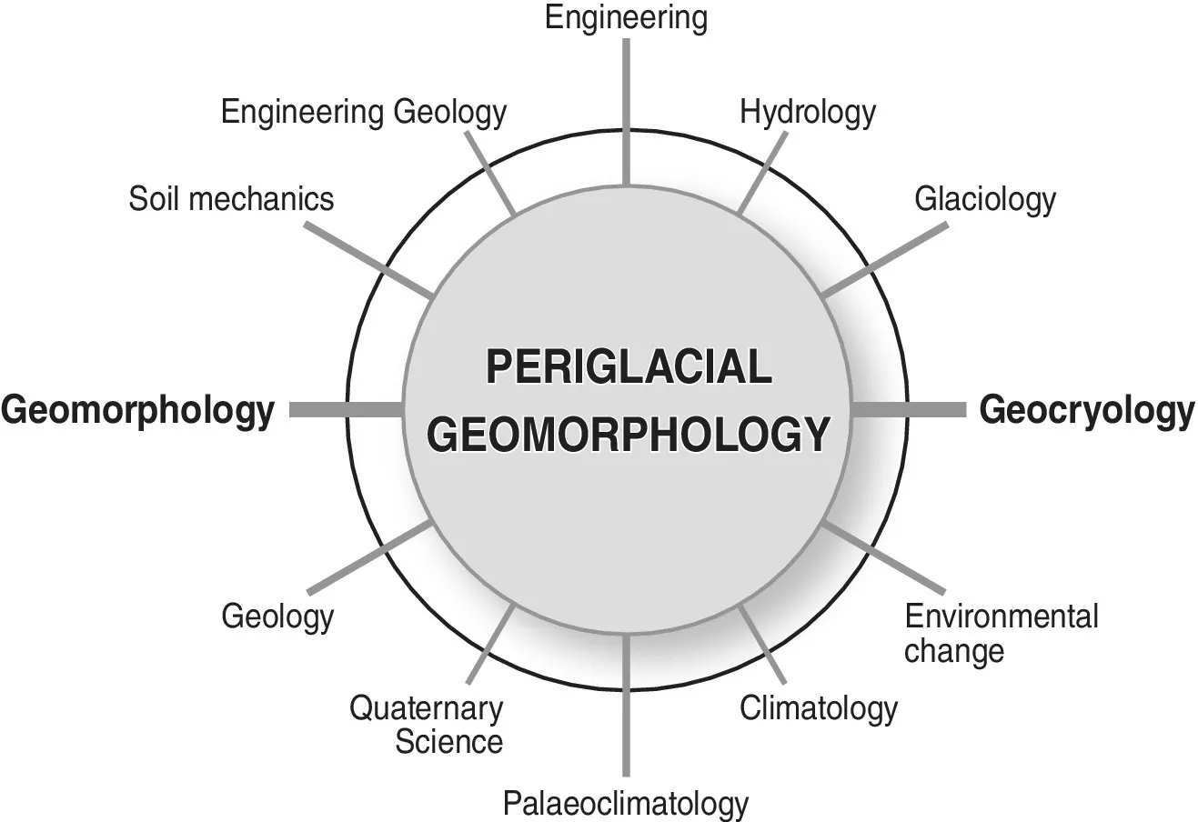
As this brief survey indicates, periglacial geomorphology is strongly integrated with several scientific disciplines. At the process‐landform core of the subject lies the interaction of geomorphology and geocryology, the science of frozen ground, but there are also strong interactions with Quaternary science, climatology, hydrology and engineering geology, and weaker but important links with a range of other disciplines (Figure 1.5).
Figure 1.5 Relationship between periglacial geomorphology and cognate sciences.
1.2 The Periglacial Realm
There are many different views regarding the geographical dimensions of what climatic geomorphologists have termed ‘the periglacial zone’ (Thorn, 1992; Berthling and Etzelmüller, 2011). This has variously been interpreted as constrained by the distribution of permafrost and/or deep seasonal ground freezing, or by climatic parameters such as the 0 °C mean annual air temperature isotherm. Such criteria are unrealistically restrictive from a geomorphological perspective. In this book, the present periglacial realm is considered to encompass all unglacierized parts of the Earth’s land surface where frozen ground or freezing and thawing of the ground significantly influences landform development, so that the present operation of periglacial processes and the distribution of resultant landforms effectively defines the extent of the periglacial domain. Similarly, the extent of former periglacial environments that existed in temperate mid‐latitudes during Quaternary cold stages can be defined by the distribution of relict periglacial landforms, deposits and soil structures.
Using similar criteria, French (2007) estimated that the present perigl...
Table of contents
Cover
Title Page
Table of Contents
Preface
Acknowledgements
1 Introduction
2 Periglacial Environments
3 Ground Freezing and Thawing
4 Permafrost
5 Ground Ice and Cryostratigraphy
6 Thermal Contraction Cracking: Ice Wedges and Related Landforms
7 Pingos, Palsas and other Frost Mounds
8 Thermokarst
9 Seasonally Frozen Ground Phenomena
10 Rock Weathering and Associated Landforms
11 Periglacial Mass Movement and Hillslope Evolution
12 Talus Slopes and Related Landforms
13 Fluvial Processes and Landforms
14 Wind Action
15 Periglacial Coasts
16 Past Periglacial Environments
17 Climate Change and Periglacial Environments
Appendix Text Abbreviations, Units and Symbols Employed in Equations
References
Index
End User License Agreement
Frequently asked questions
Yes, you can cancel anytime from the Subscription tab in your account settings on the Perlego website. Your subscription will stay active until the end of your current billing period. Learn how to cancel your subscription
No, books cannot be downloaded as external files, such as PDFs, for use outside of Perlego. However, you can download books within the Perlego app for offline reading on mobile or tablet. Learn how to download books offline
Perlego offers two plans: Essential and Complete
Essential is ideal for learners and professionals who enjoy exploring a wide range of subjects. Access the Essential Library with 800,000+ trusted titles and best-sellers across business, personal growth, and the humanities. Includes unlimited reading time and Standard Read Aloud voice.
Complete: Perfect for advanced learners and researchers needing full, unrestricted access. Unlock 1.4M+ books across hundreds of subjects, including academic and specialized titles. The Complete Plan also includes advanced features like Premium Read Aloud and Research Assistant.
Both plans are available with monthly, semester, or annual billing cycles.
We are an online textbook subscription service, where you can get access to an entire online library for less than the price of a single book per month. With over 1 million books across 990+ topics, we’ve got you covered! Learn about our mission
Look out for the read-aloud symbol on your next book to see if you can listen to it. The read-aloud tool reads text aloud for you, highlighting the text as it is being read. You can pause it, speed it up and slow it down. Learn more about Read Aloud
Yes! You can use the Perlego app on both iOS and Android devices to read anytime, anywhere — even offline. Perfect for commutes or when you’re on the go. Please note we cannot support devices running on iOS 13 and Android 7 or earlier. Learn more about using the app
Yes, you can access Periglacial Geomorphology by Colin K. Ballantyne in PDF and/or ePUB format, as well as other popular books in Physical Sciences & Geology & Earth Sciences. We have over one million books available in our catalogue for you to explore.