The fourth edition of this bestselling textbook has been fully revised in order to present the most up-to-date and comprehensive guide to completing a hydrogeological study. Beautifully presented with full colour photos and diagrams throughout, Field Hydrogeology retains its practical pocket size for easy use in the field. This new edition includes all the recent developments in the environmental regulations, with particular focus on the use of innovative technology. New topics include geothermal energy, soakaways, marrying manual water level readings with logger records, prediction of long-term drawdown and lateral extent of impacts, and flow measurement in locations with small head gradients.
With case studies and text boxes to aid comprehension, and a particular emphasis on practical application, this is an essential tool for students taking Hydrogeology and/or field course modules in Geology, Earth Sciences, Hydrogeology and Engineering courses.
Trusted by 375,005 students
Access to over 1 million titles for a fair monthly price.
Groundwater provides an important source of drinking water over much of the world. It also has the fundamental importance of maintaining river and stream flows during periods without rain and also supporting wetland sites. Groundwater is under threat worldwide from overabstraction and by contamination from a wide range of human activities. In many countries, activities that may impact on groundwater are regulated by government organisations, which frequently require hydrogeological investigations to assess the risks posed by new developments.
Pumping from new wells may reduce the quantities that can be pumped from others nearby, cause local spring flows to dwindle, or dry up wetlands. The hydrogeologist will be expected to make predictions on such effects and can only do so if he or she has a proper understanding of the local groundwater system based on adequate field observations. It is equally important to evaluate groundwater quality to ensure that it is suitable for drinking and for other uses. Groundwater commonly provides the flow path that allows pollutants to be leached from industrially contaminated sites, landfills, septic tanks, chemical storage areas and many more. Hydrogeological studies are needed to define groundwater systems in order to prevent such contamination or manage its clean-up. This book is concerned with the field techniques used by hydrogeologists to evaluate groundwater systems for any or all of these purposes and with the primary or initial interpretation of the data collected in the field.
1.1 Groundwater Systems
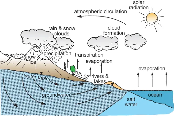
Groundwater is an integral part of the hydrological cycle, a complex system that circulates water over the whole planet; this is illustrated in Figure 1.1. The hydrological cycle starts as energy from the sun evaporates water from the oceans to form large cloud masses that are moved by the global wind system and, when conditions are right, precipitate as rain, snow or hail. Some of it falls onto land and collects to form streams and rivers, which eventually flow back into the sea, from where the process starts all over again. Not all rainfall contributes to surface water flow, as some is returned to the atmosphere by evaporation from lakes and rivers, from soil moisture and as transpiration from plants. Water that percolates through the soil to reach the water table becomes groundwater. In thick aquifers, groundwater at depth is below the depth of freshwater circulation and is saline, often with a higher electrical conductivity than seawater. The same is true for groundwater down dip from the outcrop of an aquifer. Groundwater flows through the rocks to discharge into either streams or rivers. In coastal areas, groundwater discharges into the sea, and the aquifer contains seawater at depth. The volume of water percolating into the aquifers defines the groundwater resources that both support natural systems and are available for long-term water supply development. In most groundwater studies it is necessary to consider the other components of the cycle as well as the groundwater itself in order to understand the groundwater system. Consequently, hydrogeological investigations usually include a range of field measurements to assess these parameters.
Figure 1.1The hydrological cycle.
Groundwater flow through saturated rock is driven by a hydraulic gradient, which, in unconfined aquifers, is the water table. Rocks that both contain groundwater and allow water to flow through them in significant quantities are termed aquifers. Flow rates that are considered as significant will vary from place to place and also depend on how much water is needed. Water supplies to individual houses require small groundwater flows compared to wells supplying a town. In pollution studies, even small groundwater flow rates may transport considerable amounts of contaminant over long periods of time. A critical part of the definition is that the rock allows a flow of water, rather than simply containing groundwater. Some rocks such as clays have a relatively high water content, although water is unable to flow through them easily. Other rocks may not be saturated but still have the property to permit water to flow, and therefore should be regarded in the same way as an aquifer, a clear example being the part of an aquifer formation that lies above the water table.
Unless groundwater is removed by pumping from wells, it will flow through an aquifer towards natural discharge points. These comprise springs, seepages into streams and rivers, and discharges directly into the sea. The property of an aquifer that allows fluids to flow through it is termed permeability, and this is controlled largely by geological factors. Properties of the fluid are also important, and water permeability is more correctly called hydraulic conductivity. Hydrogeologists often think of hydraulic conductivity on a field scale in terms of an aquifer's transmissivity, which is the hydraulic conductivity multiplied by the effective saturated thickness of the aquifer.
In both sedimentary rocks and unconsolidated sediments, groundwater is contained in and moves through the pore spaces between individual grains. Fracture systems in solid rocks significantly increase the hydraulic conductivity of the rock mass. Indeed, in crystalline aquifers of all types, most groundwater flow takes place through fractures, and very little, if any, moves through the body of the rock itself. Some geological materials do not transmit groundwater at significant rates, while others only permit small quantities to flow through them. Such materials are termed aquicludes and aquitards, respectively, and although they do not transmit much water, they influence the movement of water through aquifers. Very few natural materials are completely uniform and most contain aquiclude and aquitard materials.
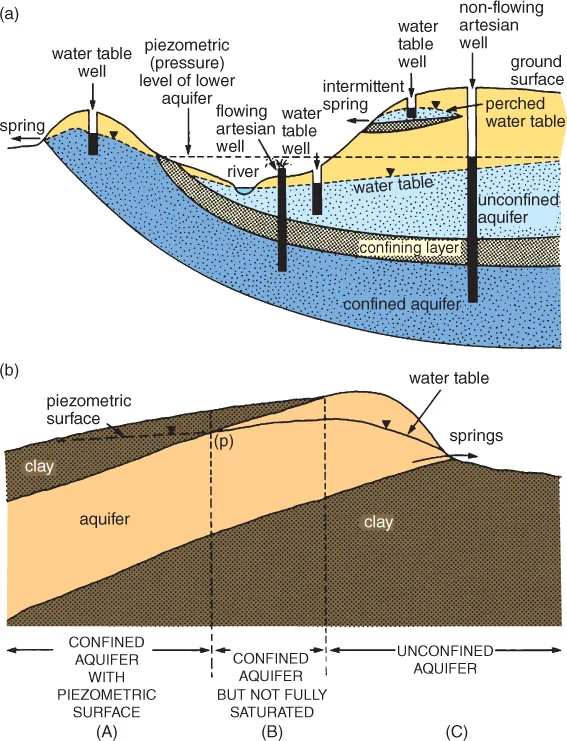
Figure 1.2 shows how the presence of an aquiclude, such as clay, can give rise to springs and may support a perched water table above the main water table in an aquifer. The top diagram (Figure 1.2a) shows a lower confined aquifer and an upper water table aquifer. The upper aquifer includes low-permeability material that supports a perched water table. The diagram shows the rest-water levels in various wells in both aquifers. Figure 1.2b shows how both confined and unconfined conditions can occur in the same aquifer. In zone A, the aquifer is fully confined by the overlying clay and is fully saturated. The groundwater in this part of the aquifer is at a pressure controlled by the level of water at point p, and water in wells would rise to this level above the top of the aquifer. In zone B, the overlying clay will prevent any direct recharge, although it is unconfined, like zone C. The aquifer in zone C is unconfined and receives direct recharge. Seasonal fluctuations in the water-table levels will alter the lateral extent of zone B along the edge of the aquifer. It is likely to be at a minimum at the end of the winter and at its greatest extent in the autumn, before winter recharge causes groundwater levels to rise.
Figure 1.2(a) A lower confined aquifer and an upper water table aquifer that includes low-permeability material supporting a perched water table. (b) Both confined and unconfined conditions can occur in the same aquifer.
Where impermeable rocks overlie an aquifer, the pressure of the groundwater body can be such that the level of water in wells would rise above the base of the overlying rock (i.e. the top of the aquifer). In such instances the aquifer is said to be confined. Sometimes this pressure may be sufficiently great that the water will rise above the ground surface and flow from wells and boreholes without pumping. This condition is termed artesian flow, and both the aquifer and the wells that tap it are said to be artesian.
A groundwater system, therefore, consists of rainfall recharge percolating into the ground down to the water table, and then flowing through rocks of varying permeabilities towards natural discharge points. The flow rates and volumes of water flowing through the system depend upon the rainfall, evaporation, the geological conditions that determine permeability, and many other factors. It is this system that a hydrogeologist is trying to understand by carrying out field measurements and interpreting the data in terms of the geology. The four key factors in achieving a successful investigation are to understand the geology; to interpret the groundwater-level data in terms of the three-dimensional (3D) distribution of heads that drive all groundwater flow systems; to remember that groundwater and surface water systems are interdependent; and to use a structured iterative approach to developing your understanding of the groundwater system you are investigating.
1.2 Conceptual Model
The foundation of all hydrogeological investigations is to gather sufficient reliable information to develop an understanding of how a particular groundwater system works. Such an understanding is usually called a conceptual model and comprises a quantified description encompassing all aspects of the local hydrogeology. Consequently, it is necessary for you to think about the way you will develop a conceptual model at the beginning of each project and as the basis of planning the work that is needed.
Although inexorably linked, the activities that form a hydrogeological investigation and the methodology of developing a conceptual model are not exactly the same. The actions at each step of a hydrogeological investigation are generally focused on collecting information, whereas the emphasis in developing a conceptual model is the interpretation of data as they are collected to identify additional information needed to complete the conceptual understanding. A typical hydrogeological investigation can be divided into a number of separate parts, each building on the previous one to eventually achieve an adequate understanding of the system being studied. It will always be necessary to tailor the details of an investigation to the needs of each particular study, although the majority of investigations are made up of the following phases:
Desk...
Table of contents
Cover
The Geological Field Guide Series
Title Page
Copyright
Table of Contents
Dedication
PREFACE
ACKNOWLEDGEMENTS
Chapter 1: INTRODUCTION
Chapter 2: DESK STUDY
Chapter 3: FIELD EVALUATION OF AQUIFERS
Chapter 4: GROUNDWATER LEVELS
Chapter 5: RAINFALL, SPRINGS AND STREAMS
Chapter 6: PUMPING TESTS
Chapter 7: GROUNDWATER CHEMISTRY
Chapter 8: RECHARGE ESTIMATION
Chapter 9: SPECIALIST TECHNIQUES
Chapter 10: PRACTICAL APPLICATIONS
Appendix A: GOOD WORKING PRACTICE
Appendix B: CONVERSION FACTORS
REFERENCES AND FURTHER READING
Index
Endorsement
End User License Agreement
Frequently asked questions
Yes, you can cancel anytime from the Subscription tab in your account settings on the Perlego website. Your subscription will stay active until the end of your current billing period. Learn how to cancel your subscription
No, books cannot be downloaded as external files, such as PDFs, for use outside of Perlego. However, you can download books within the Perlego app for offline reading on mobile or tablet. Learn how to download books offline
Perlego offers two plans: Essential and Complete
Essential is ideal for learners and professionals who enjoy exploring a wide range of subjects. Access the Essential Library with 800,000+ trusted titles and best-sellers across business, personal growth, and the humanities. Includes unlimited reading time and Standard Read Aloud voice.
Complete: Perfect for advanced learners and researchers needing full, unrestricted access. Unlock 1.4M+ books across hundreds of subjects, including academic and specialized titles. The Complete Plan also includes advanced features like Premium Read Aloud and Research Assistant.
Both plans are available with monthly, semester, or annual billing cycles.
We are an online textbook subscription service, where you can get access to an entire online library for less than the price of a single book per month. With over 1 million books across 990+ topics, we’ve got you covered! Learn about our mission
Look out for the read-aloud symbol on your next book to see if you can listen to it. The read-aloud tool reads text aloud for you, highlighting the text as it is being read. You can pause it, speed it up and slow it down. Learn more about Read Aloud
Yes! You can use the Perlego app on both iOS and Android devices to read anytime, anywhere — even offline. Perfect for commutes or when you’re on the go. Please note we cannot support devices running on iOS 13 and Android 7 or earlier. Learn more about using the app
Yes, you can access Field Hydrogeology by Rick Brassington in PDF and/or ePUB format, as well as other popular books in Technology & Engineering & Environmental Management. We have over one million books available in our catalogue for you to explore.