An authoritative work on Synthetic Aperture Radar system engineering, with key focus on high resolution imaging, moving target indication, and system engineering technology
Synthetic Aperture Radar (SAR) is a powerful microwave remote sensing technique that is used to create high resolution two or three-dimensional representations of objects, such as landscapes, independent of weather conditions and sunlight illumination. SAR technology is a multidisciplinary field that involves microwave technology, antenna technology, signal processing, and image information processing. The use of SAR technology continues grow at a rapid pace in a variety of applications such as high-resolution wide-swath observation, multi-azimuth information acquisition, high-temporal information acquisition, 3-D terrain mapping, and image quality improvement. Design Technology of Synthetic Aperture Radar provides detailed coverage of the fundamental concepts, theories, technology, and design of SAR systems and sub-systems.
Supported by the author's over two decades of research and practice experience in the field, this in-depth volume systematically describes SAR design and presents the latest research developments. Providing examination of all topics relevant to SAR—from radar and antenna system design to receiver technology and signal and image information processing—this comprehensive resource:
Provides wide-ranging, up-to-date examination of all major topics related to SAR science, systems, and software
Includes guidelines to conduct grounding system designs and analysis
Offers coverage of all SAR algorithm classes and detailed SAR algorithms suitable for enabling software implementations
Surveys SAR and computed imaging literature of the last sixty years
Emphasizes high resolution imaging, moving target indication, and system engineering
Design Technology of Synthetic Aperture Radar is indispensable for graduate students majoring in SAR system design, microwave antenna, signal and information processing as well as engineers and technicians involved in SAR system techniques.
Trusted by 375,005 students
Access to over 1.5 million titles for a fair monthly price.
Synthetic aperture radar (SAR) is a type of imaging radar that receives wideband echoes at different positions through relative movement between the loading platform and the target. Within a certain accumulating period, SAR obtains a two‐dimensional (2D) image of the target after coherently processing the received echoes, which allows high‐resolution observation of the real image of the target.
The resolution of the 2D image of the target is normally expressed as range resolution and azimuth resolution. In the range direction, high resolution can be achieved by employing the pulse compression technique in the transmitted linear frequency modulation signal, which has a large time‐width and bandwidth product. In other words, similar to conventional radar, SAR improves the range resolution by employing the pulse compression technique on the transmitted and the received linear frequency modulation signal. In the azimuth direction, one radar sensor of uniform motion in a straight line is used to transmit and receive the pulse signal at interval positions with a certain pulse repetition frequency, and then a high azimuth resolution is obtained by a coherent processing of the received echoes. To achieve a high resolution, a synthetic aperture equivalent to an actual huge but unrealizable array aperture is constructed based on the track produced from the relative movement between the target and the radar.
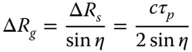
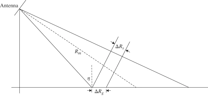
As shown in Figure 1.1, the range resolution of the radar is normally defined as the minimum distance between two points that can be distinguished. If the arrival time of the leading edge of the pulse echo at a distant point is later than the arrival time of the trailing edge of the pulse echo at a near point, then these two points are considered distinguishable. Therefore, the range resolution of two distinguishable points is given by
1.1
Figure 1.1 Sketch of range resolution.
where τp is the signal pulse width, c is the light speed, and η is the incident angle between the antenna and the ground.
It can be seen that the pulse width is required to be very narrow to achieve a high‐range resolution. However this will dramatically reduce the average power level of the radar system and will make the signal‐to‐noise ratio (SNR) of the echo of the observed target too low. A pulse compression technique is commonly employed in SAR to avoid this problem. Consequently, a relatively wider pulse can be used to realize both high resolution and high SNR.
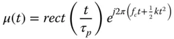
In SAR, the linear frequency modulated signal transmitted can be expressed as
1.2
where τp is the signal pulse width, fc is the center frequency of the carrier, and k is the slope of the linear modulated frequency. The bandwidth of the signal is then B=kτp. After matched filtering, the pulse width τp is compressed into 1/B, and the resolution is improved to
1.3
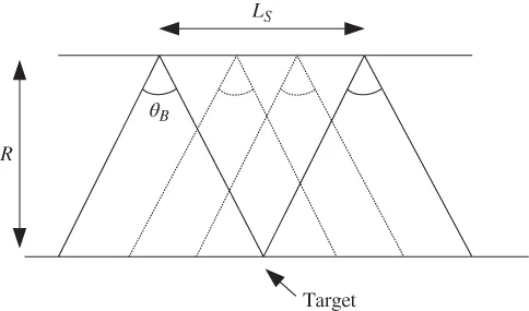
For azimuth resolution, the motion of the radar antenna with the platform forms a SAR virtual antenna array, while the physical antenna serves as a unit of the array. During the motion, the echo of the target is sequentially received and recorded, and the phase difference caused by the wave path difference of multiple antenna positions is compensated by signal processing. Therefore, the echoes of the same point target can be stacked in phase, and azimuth compression is performed to realize high azimuth resolution.
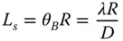
As shown in Figure 1.2, suppose the radar moving distance is Ls (the distance of the antenna beam beginning to illuminate the target to leaving the target), and the size of the antenna in the azimuth direction is D. If λ is the wavelength of the radar wave, the maximum length of synthetic aperture is determined by the actual antenna beam width θB, the distance of the target R, and the wavelength of the system, as expressed by Eq. (1.4).
1.4
Figure 1.2 Diagram of synthetic aperture.
For synthetic aperture, transmission and reception of the radar pulse are considered as two‐way propagation. The phase difference between two arbitrary array elements to the target is twice that of the single‐way transmission, hence the equivalent bandwidth of synthetic aperture is given by
1.5
After synthetic aperture processing, the azimuth resolution can be improved to
1.6
It is evident that the azimuth resolution of the synthetic aperture is irrelevant to the target distance because the further the distance, the longer the effective synthetic aperture and the narrower the formed beam. This is balanced out by the widening of the azimuth resolution unit caused by the increase of the distance, which keeps the size of the azimuth resolution unit unchanged.
From the previous discussion, SAR features a high resolution because the length of the synthetic aperture is equivalent to that of a large antenna aperture. To obtain a high‐resolution 2D image, the echoes within the coverage area of the radar beam are collected and coherently processed. Broadly speaking, SAR is also distributed radar that sequentially samples a synthetic aperture to replace the distributed antenna aperture.
1.2 SAR Applications
1.2.1 Military Applications
As SAR system technology moves forward, the resolution increases from tens of meters to meters to submeters; the polarization modes vary from single polarization to multipolarization to full polarization; the radar waveband ranges from meter‐wave band to microwave band to millimeter‐wave band to submillimeter‐wave band. Furthermore, SAR has covered military, civil, and scientific applications, where the platforms include unmanned aerial vehicles (UAVs), helicopters, fixed‐wing manned aircraft, satellites, and missiles. To fulfill different requirements, different operation modes are realized by the antenna beam scheduling, for instance, strip‐map SAR, spotlight SAR, scan SAR, moving target detection (MTD), inverse SAR (ISAR), and interferometric SAR (INSAR). At different operation modes, useful information is interpreted and extracted from SAR images, including military intelligence, mapping, marine meteorology, hydrology, geology, forestry, and object deformation. SAR plays an important role in military applications and is an indispensable and irreplaceable sensor for mapping the surface of the earth, due to its availability for high resolution, in all types of weather, and at all times.
1.2.1.1 Military Intelligence
SAR plays a very important role in obtaining military intelligence. SAR mounted on different platforms has different characteristics in military applications.
By providing reliable intelligence gathering and surveillance, spaceborne SAR performs reconnaissance missions, including military maneuvering, military target and enemy troops surveillance, and military assessment. Spaceborne SAR with different wavebands, polarizations, and resolutions has many functions in military applications [1].
Due to high mobility and time continuity of the platforms, manned aircraft and UAV SAR can make up for disadvantages in satellite observation. Airborne SAR therefore has a wide application in intelligence reconnaissance [2]. Furthermore, the features of airborne SAR include a short development cycle, rapid implementation of the most advanced techniques, ultra‐high resolution, and large‐scale search. All of these features drive the application of airborne SAR for tactical reconnaissance [3].
Missile‐borne SAR can obtain real‐time images of ground scenery in flight or real‐time images of the earth and objects along the track of the missile flying to the target [4,5]. By comparing with the reference map installed on the missile, the longitudinal or lateral deviation of the missile from the target or the predetermined track can be obtained, which further guides the missile. Missile‐borne SAR has become a hot topic because it can effectively improve the terminal guidance precision of medium‐ and long‐range attack weapons, such as camouflaged underground missile launch silos, ground objects in fog‐covered areas, etc.
1.2.1.2 Moving Target Detection
Battlefield information includes not only the precise location of the enemy, the facilities, and the deployment of the enemy troops but also the enemy tanks, armored vehicles, mobile artillery, mobile missile launchers, helicopters, cruise missiles, and the activities of mobilization and supply o...
Table of contents
Cover
Table of Contents
About the Book
Preface
1 Introduction
2 Radar System Design
3 Antenna System
4 Transmit/Receive Module
5 Receiver Technology
6 Signal Processing
7 Image Information Processing System
Index
End User License Agreement
Frequently asked questions
Yes, you can cancel anytime from the Subscription tab in your account settings on the Perlego website. Your subscription will stay active until the end of your current billing period. Learn how to cancel your subscription
No, books cannot be downloaded as external files, such as PDFs, for use outside of Perlego. However, you can download books within the Perlego app for offline reading on mobile or tablet. Learn how to download books offline
Perlego offers two plans: Essential and Complete
Essential is ideal for learners and professionals who enjoy exploring a wide range of subjects. Access the Essential Library with 800,000+ trusted titles and best-sellers across business, personal growth, and the humanities. Includes unlimited reading time and Standard Read Aloud voice.
Complete: Perfect for advanced learners and researchers needing full, unrestricted access. Unlock 1.5M+ books across hundreds of subjects, including academic and specialized titles. The Complete Plan also includes advanced features like Premium Read Aloud and Research Assistant.
Both plans are available with monthly, semester, or annual billing cycles.
We are an online textbook subscription service, where you can get access to an entire online library for less than the price of a single book per month. With over 1.5 million books across 990+ topics, we’ve got you covered! Learn about our mission
Look out for the read-aloud symbol on your next book to see if you can listen to it. The read-aloud tool reads text aloud for you, highlighting the text as it is being read. You can pause it, speed it up and slow it down. Learn more about Read Aloud
Yes! You can use the Perlego app on both iOS and Android devices to read anytime, anywhere — even offline. Perfect for commutes or when you’re on the go. Please note we cannot support devices running on iOS 13 and Android 7 or earlier. Learn more about using the app
Yes, you can access Design Technology of Synthetic Aperture Radar by Jiaguo Lu in PDF and/or ePUB format, as well as other popular books in Technology & Engineering & Civil Engineering. We have over 1.5 million books available in our catalogue for you to explore.