Provides technical and scientific descriptions of potential approaches used to achieve indoor positioning, ranging from sensor networks to more advanced radio-based systems
This book presents a large technical overview of various approaches to achieve indoor positioning. These approaches cover those based on sensors, cameras, satellites, and other radio-based methods. The book also discusses the simplification of certain implementations, describing ways for the reader to design solutions that respect specifications and follow established techniques. Descriptions of the main techniques used for positioning, including angle measurement, distance measurements, Doppler measurements, and inertial measurements are also given.
Indoor Positioning: Technologies and Performance starts with overviews of the first age of navigation, the link between time and space, the radio age, the first terrestrial positioning systems, and the era of artificial satellites. It then introduces readers to the subject of indoor positioning, as well as positioning techniques and their associated difficulties. Proximity technologies like bar codes, image recognition, Near Field Communication (NFC), and QR codes are covered—as are room restricted and building range technologies. The book examines wide area indoor positioning as well as world wide indoor technologies like High-Sensitivity and Assisted GNSS, and covers maps and mapping. It closes with the author's vision of the future in which the practice of indoor positioning is perfected across all technologies. This text:
Explores aspects of indoor positioning from both theoretical and practical points of view
Describes advantages and drawbacks of various approaches to positioning
Provides examples of design solutions that respect specifications of tested techniques
Covers infra-red sensors, lasers, Lidar, RFID, UWB, Bluetooth, Image SLAM, LiFi, WiFi, indoor GNSS, and more
Indoor Positioning is an ideal guide for technical engineers, industrial and application developers, and students studying wireless communications and signal processing.
Trusted by 375,005 students
Access to over 1.5 million titles for a fair monthly price.
In this chapter, we briefly look back at the evolution of geographical positioning. Our intention is to show that indoor positioning is indeed a very recent need that has come about due to the spread of modern mobile‐connected terminals and owners wanting to receive numerous so‐called services, many of which are greatly enhanced when associated with the user location. The benefit of many of them is 10‐fold when associated with the user location. Thanks to the Global Positioning System, the famous GPS, this association was made possible in the early 1990s. Unfortunately, this fantastic system has been unable to meet the performance required indoors, where a “typical” urban citizen spends the majority of his or her time (The term “typical” will appear sometimes in the book. Although experience has shown such “typical” persons, objects, or environments do not exist, we will use this term to appoint a classical situation).
As soon as human beings decided to explore new territories, or even just to move within new territories, they needed a way to locate themselves in their environment.
1.1 The First Age of Navigation
The origins of navigation are as old as man himself. The oldest traces have been found in Neolithic deposits and in Sumerian tombs, dating back to around 4000 years CE The story of navigation is strongly related to the history of instruments, although they did not have a rapid development until the invention of the maritime clock, thanks to John and James Harrison, in the eighteenth century. The first reason that pushed people to “take to the sea” is probably related to both the quest for discovery and the necessity of developing commercial activities. In the beginning, navigation was carried out without instruments and was limited to “keeping the coast in view.” It is likely that numerous adventurers lost their lives by trying to approach what was “over the horizon.”
The astronomical process used for positioning was quite inaccurate, and hence, frequent readjustments were required. The localization was even more complex because of the lack of maps. Nowadays, the situation of indoor positioning is in the same state: accuracy is not at the desired level, and frequent readjustments are needed. Moreover, one of the most important problems is the lack of indoor maps allowing navigation (i.e. not just an image). This very hot topic is dealt with in Chapter 13.
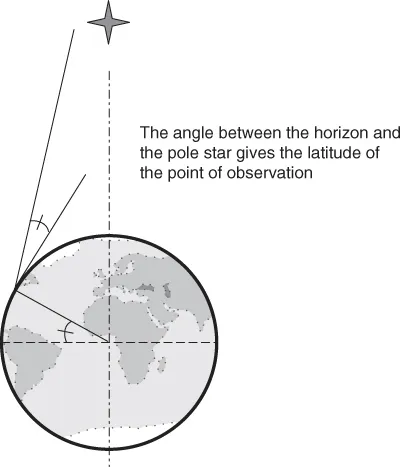
Unfortunately, astronomical positioning was only able to give the latitude of the point, as can be understood from Figure 1.1. The longitude problem would remain unresolved for centuries: will it be the same for indoor positioning?1
Figure 1.1 Determining latitude with the pole star.
A first remark can be made at this stage: positioning at the epoch was not continuous in time and space, contrary to what we are looking for today. However, is it really essential indoors?
1.2 Longitude Problem and Importance of Time
The so‐called longitude problem was much more difficult to solve and took almost three centuries. During this period, significant progress occurred concerning instruments and maps, but nothing for determining the longitude. As early as 1598, Philipp II of Spain offered a prize to whoever might find the solution. In 1666, in France, Colbert founded the “Académie des Sciences” and built the Observatory of Paris: one of his first goals was to find a method to determine longitude. King Charles II also founded the British Royal Observatory in 1675 in Greenwich to solve this problem of finding the longitude at sea. Giovanni Domenica Cassini, a professor of astronomy in Bologna, Italy, was the first director of the French academy and in 1668 proposed a method of finding the longitude based on the observations of the moons of Jupiter: this work followed the observations made by Galileo2 concerning these moons using an astronomical telescope. It had been known from the beginning of the sixteenth century that the time of the observation of a physical phenomenon could be linked to the location of the observation; thus, knowing the local time where the observations were made compared to the time of the original observation (carried out at a reference location) could give the longitude. Cassini established this fact with the moons of Jupiter after having calculated very accurate ephemeris. Unfortunately, this approach needs the use of a telescope and is not practically applicable at sea.
On 11 June 1714, Sir Isaac Newton confirmed that Cassini's solution was not applicable at sea and that the availability of a transportable timekeeper would be of great interest. It has to be noticed that Gemma Frisius also mentioned this around 1550, but it was probably too early. On 8 July 1714, Queen Anne offered, by Act of Parliament, a £20 000 prize3 to whoever could provide longitude to within half a degree. The solution had to be tested in real conditions during a return trip to India (or equivalent), and the accuracy, practicability, and usefulness had to be evaluated. Depending on the success of the corresponding results, a smaller part of the prize would be awarded.
The development of such a maritime timekeeper took decades to be achieved but finally had an impact on far more than navigation. The history of Harrison's clocks is quite interesting, and time is really the fundamental of modern satellite navigation capabilities. We have seen that Isaac Newton himself confirmed that the availability of a transportable maritime clock would be the solution to the longitude problem: the realization of such a clock, however, was not so easy. The main reason is that the clock industry was fundamentally based on physical principles dependent on gravitation (the pendulum). This was acceptable for terrestrial needs, but of no help in keeping time when sailing. Thus, a new system had to be found.
The reason that time is of such importance is because of the Earth's motion around its axis. As the Earth makes a complete rotation in 24 hours, it means that every hour corresponds to an eastward rotation of 15°. Thus, let us suppose that one knows a reference configuration of stars (or the position of the sun or the moon) at a given time and for a given well‐known location (e.g. Greenwich). If you stay at the same latitude, then you will be able to observe the same configuration but at another time (later if you are eastward and earlier if westward): the difference in times directly gives the longitude, as long as the time of the reference location (Greenwich in the present example) has been kept. The longitude is simply obtained by multiplying this difference by 15° per hour, eastward or westward. The method is very simple and the major difficulty is to “keep” the time of the reference place with a good enough accuracy, i.e. with a drift less than a few seconds per day. Pendulums, although of good accuracy on land, were unable to provide this accuracy at sea, mainly because of the motions of the ship and changes in humidity and temperature.
John Harrison built four different clocks, leading to numerous innovative concepts. After almost 50 years of remarkable achievements (August 1765), a panel of six experts gathered at Harrison's house in London and examined the final “H4” watch. John and William (his son) finally received the first half of the longitude prize. The other half was finally awarded to them by the Act of Parliament in June 1773. Certainly more important is the fact that John Harrison was finally recognized as being the man who solved the longitude problem.
One of the most famous demonstrations of Harrison's clocks' efficiency was given by James Cook during the second of his three famous voyages in the Pacific Ocean. This second trip was dedicated to the exploration of Antarctica. In April 1772, he sailed south with two ships: the Resolution and the Adventure. He spent 171 days sailing through the ice of the Antarctic and decided to sail back to the Pacific islands. He returned to London harbor in June 1775, after more than 40 000 nautical miles. During this voyage, he was carrying K1, Kendall's copy of Harrison's H4. The daily rate of loss of K1 never exceeded eight seconds (corresponding to a distance of two nautical miles at the equator) during the entire voyage: this was the proof that longitude could be measured from a watch.
Indoor positioning is almost in the same situation as that of the longitude determination in the early eighteenth century: it seems to be quite close, but there is indeed no satisfactory solution. Hopefully, it will take less than 50 years to find an acceptable approach.
1.3 Link Between Time and Space
The perception of time has changed quite a lot over the centuries until the current omnipresent availability of a precise time that can thus be shared by everybody. By briefly analyzing the evolution of the effects of this availability of time on people's life, some parallels are drawn concerning possible changes induced by the availability of positioning.
1.3.1 A Brief History of the Evolution of the Perception of Time
At the very beginning, time and space were notions that people felt: the number of days of walk needed to reach a g...
Table of contents
Cover
Table of Contents
Preface
Acknowledgments
Introduction
1 A Little Piece of History …
2 What Exactly Is the Indoor Positioning Problem?
3 General Introduction to Positioning Techniques and Their Associated Difficulties
4 Various Possible Classifications of Indoor Technologies
5 Proximity Technologies: Approaches, Performance, and Limitations
6 Room‐Restricted Technologies: Challenges and Reliability
7 “Set of Rooms” Technologies
8 Building Range Technologies
9 Building Range Technologies: The Specific Case of Indoor GNSS
10 Wide Area Indoor Positioning: Block, City, and County Approaches
Yes, you can cancel anytime from the Subscription tab in your account settings on the Perlego website. Your subscription will stay active until the end of your current billing period. Learn how to cancel your subscription
No, books cannot be downloaded as external files, such as PDFs, for use outside of Perlego. However, you can download books within the Perlego app for offline reading on mobile or tablet. Learn how to download books offline
Perlego offers two plans: Essential and Complete
Essential is ideal for learners and professionals who enjoy exploring a wide range of subjects. Access the Essential Library with 800,000+ trusted titles and best-sellers across business, personal growth, and the humanities. Includes unlimited reading time and Standard Read Aloud voice.
Complete: Perfect for advanced learners and researchers needing full, unrestricted access. Unlock 1.5M+ books across hundreds of subjects, including academic and specialized titles. The Complete Plan also includes advanced features like Premium Read Aloud and Research Assistant.
Both plans are available with monthly, semester, or annual billing cycles.
We are an online textbook subscription service, where you can get access to an entire online library for less than the price of a single book per month. With over 1.5 million books across 990+ topics, we’ve got you covered! Learn about our mission
Look out for the read-aloud symbol on your next book to see if you can listen to it. The read-aloud tool reads text aloud for you, highlighting the text as it is being read. You can pause it, speed it up and slow it down. Learn more about Read Aloud
Yes! You can use the Perlego app on both iOS and Android devices to read anytime, anywhere — even offline. Perfect for commutes or when you’re on the go. Please note we cannot support devices running on iOS 13 and Android 7 or earlier. Learn more about using the app
Yes, you can access Indoor Positioning by Nel Samama in PDF and/or ePUB format, as well as other popular books in Technology & Engineering & Signals & Signal Processing. We have over 1.5 million books available in our catalogue for you to explore.