1.1 Scope of this book
This book is about the study of hydrogeology and the significance of groundwater in the terrestrial aquatic environment. Water is a precious natural resource, without which there would be no life on Earth. We, ourselves, are comprised of two-thirds water by body weight. Our everyday lives depend on the availability of inexpensive, clean water and safe ways to dispose of it after use. Water supplies are also essential in supporting food production and industrial activity. As a source of water, groundwater obtained from beneath the Earth's surface is often cheaper, more convenient and less vulnerable to pollution than surface water.
Groundwater, because it is unnoticed underground, is often unacknowledged and undervalued resulting in adverse environmental, economic and social consequences. The over-exploitation of groundwater by uncontrolled pumping can cause detrimental effects on neighbouring boreholes and wells, land subsidence, saline water intrusion and the drying out of surface waters and wetlands. Without proper consideration for groundwater resources, groundwater pollution from uncontrolled uses of chemicals and the careless disposal of wastes on land cause serious impacts requiring difficult and expensive remediation over long periods of time. Major sources of contamination include agrochemicals, industrial and municipal wastes, tailings and process wastewater from mines, oil field brine pits, leaking underground storage tanks and pipelines, and sewage sludge and septic systems.
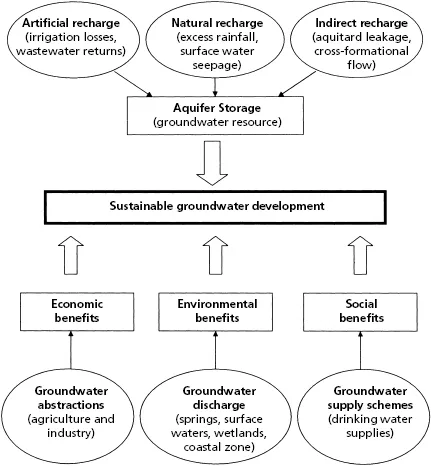
Achieving sustainable development of groundwater resources by the future avoidance of over-exploitation and contamination is an underlying theme of this book. By studying topics such as the properties of porous material, groundwater flow theory and geological processes, well hydraulics, groundwater chemistry, environmental isotopes, contaminant hydrogeology and techniques of groundwater remediation and aquifer management, it is our responsibility to manage groundwater resources to balance environmental, economic and social requirements and achieve sustainable groundwater development (Fig. 1.1).
The 10 chapters of this book aim to provide an introduction to the principles and practice of hydrogeology and to explain the role of groundwater in the aquatic environment. Chapter 1 provides a definition of hydrogeology and charts the history of the development of hydrogeology as a science. The water cycle is described and the importance of groundwater as a natural resource is explained. The legislative framework for the protection of groundwater resources is introduced with reference to industrialized and developing countries. Chapters 2–4 discuss the principles of physical and chemical hydrogeology that are fundamental to an understanding of the occurrence, movement and chemistry of groundwater in the Earth's crust. The relationships between geology and aquifer conditions are demonstrated both in terms of flow through porous material and rock-water interactions. Chapter 5 provides an introduction to the application of environmental isotopes in hydrogeological investigations for assessing the age of groundwater recharge and includes a section on noble gases to illustrate the identification of palaeowaters and aquifer evolution.
In the second half of this book, Chapters 6 and 7 provide an introduction to the range of field investigation techniques used in the assessment of catchment water resources and includes stream gauging methods, well hydraulics and tracer techniques. The protection of groundwater from surface contamination requires knowledge of solute transport processes and Chapter 8 introduces the principles of contaminant hydrogeology. Chapter 8 also covers water quality criteria and discusses the nature of contamination arising from a variety of urban, industrial and agricultural sources and also the causes and effects of saline intrusion in coastal regions. The following Chapter 9 discusses methods of groundwater pollution remediation and protection, and includes sections that introduce risk assessment methods and spatial planning techniques. The final chapter, Chapter 10, returns to the topic of catchment water resources and demonstrates integrated methods for aquifer management together with consideration of groundwater interactions with rivers and wetlands, as well as the potential impacts of climate change on groundwater.
Each chapter in this book concludes with recommended further reading to help extend the reader's knowledge of hydrogeology. In addition, for students of hydrogeology, a set of discursive and numerical exercises is provided in Appendix 10 to provide practice in solving groundwater problems. The remaining appendices include data and information in support of the main chapters of this book and will be of wider application in Earth and environmental sciences.
1.2 What is hydrogeology?
Typical definitions of hydrogeology emphasize the occurrence, distribution, movement and geological interaction of water in the Earth's crust. Hydrogeology is an interdisciplinary subject and also encompasses aspects of hydrology. Hydrology has been defined as the study of the occurrence and movement of water on and over the Earth's surface independent of the seepage of groundwater and springs which sustain river flows during seasonal dry periods. However, too strict a division between the two subjects is unhelpful, particularly when trying to decipher the impact of human activities on the aquatic environment. How well we respond to the challenges of pollution of surface water and groundwater, the impacts of over-exploitation of water resources, and the potential impact of climate change will depend largely on our ability to take a holistic view of the aquatic environment.
1.3 Early examples of groundwater exploitation
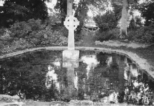
The vast store of water beneath the ground surface has long been realized as an invaluable source of water for human consumption and use. Throughout the world, springs fed by groundwater are revered for their life-giving or curative properties (see Fig. 1.2), and utilization of groundwater long preceded understanding of its origin, occurrence and movement.
Evidence for some of the first wells to be used by modern humans is found in the far west of the Levant on the island of Cyprus. It is likely that Cyprus was first colonized by farming communities in the Neolithic, probably sailing from the Syrian coast about 9000 BC (Mithen 2012). Several Neolithic wells have been excavated from known settlements in the region of Mylouthkia on the west coast of Cyprus (Peltenberg et al. 2000). The wells are 2 m in diameter and had been sunk at least 8 m through sediment to reach groundwater in the bedrock. The wells lacked any internal structures or linings other than small niches within the walls, interpreted as hand- and foot-holds to allow access during construction and for cleaning. When abandoned, the wells were filled with domestic rubbish which dates from 8300 BC, indicating that the wells had been built at or just before this date (Mithen 2012).
Wells from the Neolithic period are also recorded in China, a notable example being the wooden Hemudu well in Yuyao County, Zhejiang Province, in the lower Yangtze River coastal plain. Based on carbon-14 dating of the well wood, it is inferred that the well was built in 3710 ± 125 BC (Zhou et al. 2011). The depth of the well was only 1.35 m with over 200 wooden components used in its construction comprising an outer part of 28 piles surrounding a pond, and an inner part, the wooden well itself, in the centre of the pond. The walls of the well were lined with close-set timber piles reinforced by a square wooden frame. The 28 piles in the outer part of the site may have been part of a shelter for the well, suggesting awareness by the people of the Hemudu culture that their water source required protection (Zhou et al. 2011).
Evidence for the appearance of dams, wells and terraced walls, three methods of water management, is widespread by the Early Bronze Age from 3600 BC, as part of what has been termed a ‘Water Revolution’ (Mithen 2012). The recognisable development of groundwater as part of a water management system also dates from ancient times, as manifest by the wells and horizontal tunnels known as qanats (ghanats) or aflaj (singular, falaj), both Arabic terms describing a small, artificial channel excavated as part of a water distribution system, which appear to have originated in Persia about 3000 years ago. Examples of such systems are found in a band across the arid regions extending from Afghanistan to Morocco. In Oman, the rural villages and aflaj-supplied oases lie at the heart of Omani culture and tradition. The system of participatory management of communal aflaj is an ancient tradition in Oman by which common-property flows are channelled and distributed to irrigation plots on a time-based system, under the management of a local community (Young 2002).
Figure 1.3 shows a cross-section along a qanat with its typical horizontal or gently sloping gallery laboriously dug through alluvial material, occasionally up to 30 km in length, and with vertical shafts dug at closely spaced intervals to provide access to the tunnel. Groundwater recharging the alluvium in the mountain foothills is fed by gravity flow from beneath the water table at the upper end of the qanat to a ground surface outlet and irrigation canal on the arid plain at its lower end (Fig. 1.4). The depth of the mother well (Fig. 1.3) is normally less than 50 m. Discharges, which vary seasonally with water table fluctuations, seldom exceeding 3 m3 s−1.