Start designing today with this hands-on beginner's guide to AutoCAD Civil 3D 2016
AutoCAD Civil 3D 2016 Essentials gets you quickly up to speed with the features and functions of this industry-leading civil engineering software. This full-color guide features approachable, hands-on exercises and additional task-based tutorials that help you quickly become productive as you master the fundamental aspects of AutoCAD Civil 3D design. Each chapter opens with a quick discussion of concepts and learning goals, and then briskly moves into tutorial mode with screen shots that illustrate each step of the process. The emphasis is on skills rather than tools, and the clear delineation between "why" and "how" makes this guide ideal for quick reference. The companion website provides starting and ending files for each exercise, so you can jump in at any point and compare your work with the pros. Centered around the real-world task of designing a residential subdivision, these exercises get you up to speed with the program's functionality, while also providing the only Autodesk-endorsed preparation for the AutoCAD Civil 3D certification exam.
Master the AutoCAD Civil 3D 2016 interface and basic tasks
Model terrain using imported field survey data
Analyze boundaries, pipe networks, surfaces, and terrain
Estimate quantities and create construction documentation
If you're ready to acquire this must-have skillset, AutoCAD Civil 3D 2016 Essentials will get you up to speed quickly and easily.
Trusted by 375,005 students
Access to over 1.5 million titles for a fair monthly price.
If you’re new to the AutoCAD® Civil 3D® software environment, then your first experience has probably been a lot like staring at the instrument panel of an airplane. Civil 3D can be quite intimidating, with lots of buttons, strange shapes, and unusual icons—all packed into a relatively small area. In addition, you may be even more intimidated by the feeling that there is a lot of power under the hood.
This leads us to our main objective for this chapter, which is to alleviate that feeling of intimidation and make you feel much more at ease within the Civil 3D environment. Let me start you down that path by saying that there’s a big difference between an airplane and Civil 3D. In Civil 3D, if you really mess up, you can simply close the drawing file without saving. When piloting an airplane, it’s a little more difficult to undo your mistakes.
After completing this chapter, you will have achieved a greater comfort level within the Civil 3D environment by being able to identify the main user interface components and utilize them for basic functions. You will also be able to use two specific features that will serve you well throughout the program: the Transparent Commands toolbar and the Inquiry Tool.
In this chapter, you’ll learn to:
Navigate the Civil 3D user interface
Launch general commands through the application menu
Launch key software commands and functions using the ribbon
Navigate the design contents using the Toolspace
Navigate the model using the drawing area
Communicate with Civil 3D using the command line
Access and modify design information using Panorama
Access specialized commands using the Transparent Commands toolbar
Get information about your design using the Inquiry Tool
Getting to Know the Civil 3D User Interface
To begin learning about the Civil 3D environment, let’s take our airplane analogy down a notch and think about this as learning to drive an automobile. When your parents first sat you down at the wheel and talked about the car’s controls, they probably didn’t mention the air conditioning or the radio. Those, of course, are important parts of the driving experience, but I’m betting they started with the most important parts, such as the steering wheel, the gas pedal, and, most important of all, the brake pedal. We’re going to approach your first experience with “driving” Civil 3D in much the same manner.
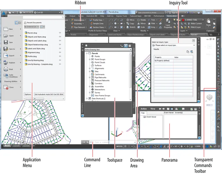
There are many, many parts to the Civil 3D user interface. For the purpose of this book, I’ll cover just the ones that will be most important in enabling you to navigate the software effectively. Figure 1-1 shows the major components of the user interface.
Figure 1-1: Major components of the Civil 3D user interface
Application Menu The place where you can find everyday file-handling commands that enable you to do things like open, save, and print your drawings
Ribbon The place where most Civil 3D commands are launched
Toolspace The Civil 3D “command center” where all the data and settings are laid out in an organized fashion
Drawing Area The place where the drawing is created
Command Line The “chat window” where you and Civil 3D talk to one another
Panorama A multipurpose window where you can view and/or edit drawing information and properties
Inquiry Tool A tool with many smaller tools within it that enable you to get information about your design
Transparent Commands Toolbar A toolbar with special commands that allow drafting and geometric construction to be done in the way that civil engineers and surveyors do it
Working with the Application Menu
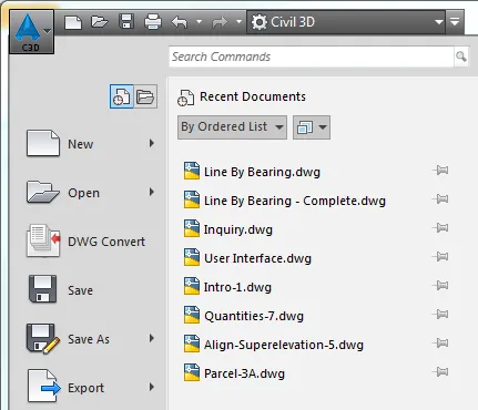
The application menu (see Figure 1-2) expands out from the square AutoCAD Civil 3D icon located at the top left of your screen. Here, you’ll find commands for creating, opening, saving, and printing your drawing files.
The Quick Access Toolbar just to the right of the AutoCAD Civil 3D icon is a handy subset of your most commonly used general-purpose tools. It can be customized to add more tools if you like.
Figure 1-2: Part of the Civil 3D application menu
Exercise 1.1: Use the Application Menu to Open a File
If you haven’t already done so, download and install the files for Chapter 1 according to the instructions in this book’s Introduction.
In this exercise, you will use the application menu to open a file.
Launch Civil 3D by double-clicking the ...
Table of contents
Cover
Titlepage
Credits
Copyright
Dedication
Acknowledgments
About the Author
Introduction
Chapter 1: Navigating the User Interface
Chapter 2: Leveraging a Dynamic Environment
Chapter 3: Establishing Existing Conditions Using Survey Data
Chapter 4: Modeling the Existing Terrain Using Surfaces
Chapter 5: Designing in 2-D Using Alignments
Chapter 6: Displaying and Annotating Alignments
Chapter 7: Designing Vertically Using Profiles
Chapter 8: Displaying and Annotating Profiles
Chapter 9: Designing in 3D Using Corridors
Chapter 10: Creating Cross Sections of the Design
Chapter 11: Displaying and Annotating Sections
Chapter 12: Designing and Analyzing Boundaries Using Parcels
Chapter 13: Displaying and Annotating Parcels
Chapter 14: Designing Gravity Pipe Networks
Chapter 15: Designing Pressure Pipe Networks
Chapter 16: Displaying and Annotating Pipe Networks
Chapter 17: Designing New Terrain
Chapter 18: Analyzing, Displaying, and Annotating Surfaces
Appendix: AutoCAD Civil 3D 2016 Certification
End-User License Agreement
Frequently asked questions
Yes, you can cancel anytime from the Subscription tab in your account settings on the Perlego website. Your subscription will stay active until the end of your current billing period. Learn how to cancel your subscription
No, books cannot be downloaded as external files, such as PDFs, for use outside of Perlego. However, you can download books within the Perlego app for offline reading on mobile or tablet. Learn how to download books offline
Perlego offers two plans: Essential and Complete
Essential is ideal for learners and professionals who enjoy exploring a wide range of subjects. Access the Essential Library with 800,000+ trusted titles and best-sellers across business, personal growth, and the humanities. Includes unlimited reading time and Standard Read Aloud voice.
Complete: Perfect for advanced learners and researchers needing full, unrestricted access. Unlock 1.5M+ books across hundreds of subjects, including academic and specialized titles. The Complete Plan also includes advanced features like Premium Read Aloud and Research Assistant.
Both plans are available with monthly, semester, or annual billing cycles.
We are an online textbook subscription service, where you can get access to an entire online library for less than the price of a single book per month. With over 1.5 million books across 990+ topics, we’ve got you covered! Learn about our mission
Look out for the read-aloud symbol on your next book to see if you can listen to it. The read-aloud tool reads text aloud for you, highlighting the text as it is being read. You can pause it, speed it up and slow it down. Learn more about Read Aloud
Yes! You can use the Perlego app on both iOS and Android devices to read anytime, anywhere — even offline. Perfect for commutes or when you’re on the go. Please note we cannot support devices running on iOS 13 and Android 7 or earlier. Learn more about using the app
Yes, you can access AutoCAD Civil 3D 2016 Essentials by Eric Chappell in PDF and/or ePUB format, as well as other popular books in Computer Science & CAD-CAM. We have over 1.5 million books available in our catalogue for you to explore.