
eBook - ePub
Ohio
A History of the Buckeye State
Kevin F. Kern, Gregory S. Wilson
This is a test
Buch teilen
- English
- ePUB (handyfreundlich)
- Über iOS und Android verfügbar
eBook - ePub
Ohio
A History of the Buckeye State
Kevin F. Kern, Gregory S. Wilson
Angaben zum Buch
Buchvorschau
Inhaltsverzeichnis
Quellenangaben
Über dieses Buch
Ohio: A History of the Buckeye State explores the breadth of Ohio's past, tracing the course of history from its earliest geological periods to the present day in an accessible, single-volume format.
- Features the most up-to-date research on Ohio, drawing on material in the disciplines of history, archaeology, and political science
- Includes thematic chapters focusing on major social, economic, and political trends
- Amply illustrated with maps, drawings, and photographs
Receipient of the Ohio Geneological Society's Henry Howe Award in 2014
Häufig gestellte Fragen
Wie kann ich mein Abo kündigen?
Gehe einfach zum Kontobereich in den Einstellungen und klicke auf „Abo kündigen“ – ganz einfach. Nachdem du gekündigt hast, bleibt deine Mitgliedschaft für den verbleibenden Abozeitraum, den du bereits bezahlt hast, aktiv. Mehr Informationen hier.
(Wie) Kann ich Bücher herunterladen?
Derzeit stehen all unsere auf Mobilgeräte reagierenden ePub-Bücher zum Download über die App zur Verfügung. Die meisten unserer PDFs stehen ebenfalls zum Download bereit; wir arbeiten daran, auch die übrigen PDFs zum Download anzubieten, bei denen dies aktuell noch nicht möglich ist. Weitere Informationen hier.
Welcher Unterschied besteht bei den Preisen zwischen den Aboplänen?
Mit beiden Aboplänen erhältst du vollen Zugang zur Bibliothek und allen Funktionen von Perlego. Die einzigen Unterschiede bestehen im Preis und dem Abozeitraum: Mit dem Jahresabo sparst du auf 12 Monate gerechnet im Vergleich zum Monatsabo rund 30 %.
Was ist Perlego?
Wir sind ein Online-Abodienst für Lehrbücher, bei dem du für weniger als den Preis eines einzelnen Buches pro Monat Zugang zu einer ganzen Online-Bibliothek erhältst. Mit über 1 Million Büchern zu über 1.000 verschiedenen Themen haben wir bestimmt alles, was du brauchst! Weitere Informationen hier.
Unterstützt Perlego Text-zu-Sprache?
Achte auf das Symbol zum Vorlesen in deinem nächsten Buch, um zu sehen, ob du es dir auch anhören kannst. Bei diesem Tool wird dir Text laut vorgelesen, wobei der Text beim Vorlesen auch grafisch hervorgehoben wird. Du kannst das Vorlesen jederzeit anhalten, beschleunigen und verlangsamen. Weitere Informationen hier.
Ist Ohio als Online-PDF/ePub verfügbar?
Ja, du hast Zugang zu Ohio von Kevin F. Kern, Gregory S. Wilson im PDF- und/oder ePub-Format sowie zu anderen beliebten Büchern aus Historia & Historia de Norteamérica. Aus unserem Katalog stehen dir über 1 Million Bücher zur Verfügung.
Information
1
Ohio Before Ohio
State Geology and Topography
The history of Perry County, which sits in predominantly rural south central Ohio, is in many ways representative of the history of the state as a whole. The northern half underwent several phases of glaciation while the southern half lies in the more rugged unglaciated Allegheny Plateau. Lying just to the south of the famous prehistoric Newark Earthworks and Flint Ridge quarries, the county has numerous Woodland-period mounds as well as much older outcrops of the Flint Ridge and Upper Mercer flints that Ohio’s earliest inhabitants prized highly. The county boasts several locations on the National Register of Historic Places, including Somerset’s Saint Joseph’s Church (the state’s first Catholic Church) and Somerset’s Old Courthouse (the oldest continuously used public building in the Northwest Territory). Although agriculture has always been important to the county other commercial pursuits have traditionally driven its economy. The National Ceramic Museum and Heritage center in Roseville celebrates only one of the many industries that once flourished in the area. Salt-making, centered in McCuneville, was the county’s first industry, followed soon thereafter by lime production in Maxville. By the middle of the nineteenth century mining started in earnest, and for a while Perry was the largest coal-producing county in the state, with major operations in the “black diamond” region of Shawnee, Congo, and New Straitsville. This combined with locally produced lime and the iron ore, found primarily in the southern part of the county, gave rise to a significant smelting industry with as many as seven blast furnaces operating within the county by the late 1800s. Commercial production of gas and oil in Corning and Junction City had augmented this economic boom by the early 1890s with the county reaching its peak population in the 1920s. As with the rest of the Appalachian region, Perry County faced increasingly difficult times starting with the Great Depression and has never fully recovered from the decline of its mining and iron industries. By the late twentieth century the county experienced increasingly low median incomes and high unemployment. Nevertheless, the county is still home to some of its historic industries, including the ceramic manufacturers Petro Ware in Crooksville and CertainTeed Corporation/Ludowic Roof Tile in New Lexington (the world’s largest roofing tile firm).
However well Perry County may represent the highs and lows of Ohio’s social and economic development it is an even better exemplar of the significance of Ohio’s geology to its development. The flint obtained from Flint Ridge, which was such a valuable resource for early Native American groups, was a product of a unique set of silicon dioxide deposits made during the Pennsylvanian period. The saltwater that created Perry County’s early salt mining industry was a remnant of Silurian period seas that covered the area, and one can trace its lime industry to the shells of the creatures that lived in those seas. The clays that formed the basis of the county’s enduring ceramic industry—as well as the bricks that make up Saint Joseph’s Church and Somerset’s Old Courthouse—were drawn from deposits made by Mississippian and Pennsylvanian seas and by glaciers that came hundreds of millions of years later. The iron ore processed by Perry County blast furnaces, as well as the coal that made them run, came from the Pennsylvanian period, while the limestone used as flux to remove impurities from the iron came primarily from the Devonian and Mississippian periods. Life forms from these periods probably formed the gas and oil that Ohioans began to use in the late nineteenth century. The 21 percent of Perry County’s land that is used for agriculture has a complex geological signature with the rich soil having developed from both the erosion of ancient rock strata and relatively more recent glacial deposits. Although most residents there probably give it little thought, Perry County’s history has been at least half a billion years in the making.
This case study of just one of Ohio’s eighty-eight counties shows how important an understanding of Ohio geology is to understanding its history. To comprehend what happened to Ohioans through the ages, it is first necessary to appreciate what went on beneath their feet. Their stories and lives, explored in this book, are inextricably entwined with the nature of the land.
Geology
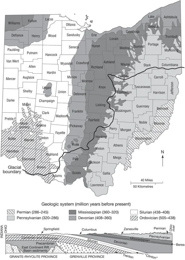
The substructure of Ohio can be thought of as a kind of multilayered cake that has been pushed up from the bottom and shaved off the top, leaving slanting edges of layers exposed on the surface. This differential exposure has given different regions of Ohio different surface rock types and resources. Each of these exposed strata, plus others that remain buried far beneath the surface, are the product of millions of years of geological processes. Figure 1.1, a geologic map of Ohio, shows the formations beneath Ohioan’s feet.
Figure 1.1 Geologic map and cross-section of Ohio.
Source: Ohio Department of Natural Resources, Division of Geological Survey
Precambrian era
The oldest, “basement,” layer of Ohio’s substructure is a several-mile-thick and multilayered sheet of igneous and metamorphic rocks laid down between 1.5 billion and 800 million years ago. The most notable feature of this layer is the eastern edge of the “Granite-Rhyolite Province,” an uprising or “superswell” in the earth’s mantle under what is now Ohio and states farther west. This extending and splitting of the crust created a deep feature called the East Continent Rift Basin. At about the time that the superswell activity ceased, the continent that would become North America—of which Eastern Ohio lay on the edge—collided with another protocontinent to the east. The impact caused significant compression of the crust, the formation of faults, and a prehistoric range (known as the Grenville Mountains) that was gradually worn down over the following hundreds of millions of years.
Ohio’s Precambrian layer is not visible anywhere in the state, lying anywhere between 2,500 and 13,000 feet below the surface. Although it cannot be seen sometimes it can be felt. The relatively minor earthquakes that sometimes occur in Ohio arise from the rifts and faults of its basement layer.
Paleozoic era
At the end of the Precambrian era (about 570 million years ago) the continent that became North America began to separate from the one it had collided with 300 million years earlier. Sitting on the edge of the continent Ohio was engulfed by the body of water geologists call the Iapetus Ocean. For most of the next 300 million years much or all of Ohio lay under water. This era is known as the Paleozoic and it marked by the proliferation of multicellular marine life forms worldwide. This era is the most significant to Ohio geology, not only because of the various resources these life forms left behind, but also because nearly all of the strata that comprise Ohio’s current surface were laid down during this time.
Cambrian and Ordovician periods
When the Iapetus Ocean flooded what is now Ohio it brought new geologic processes to bear on the landscape. It deposited layer after layer of silt, sand, mud, as well as shells and skeletons of countless sea creatures over the course of what is known as the Cambrian period. During the early Cambrian period most of Ohio was under a relatively shallow, tropical ocean shelf that left a thick layer (as much as 400 feet in some places) of sandstone. An above-water feature that geologists call the Kerbel Delta formed in north and central Ohio during the middle Cambrian period. At the same time ocean waters began to rise. By the late Cambrian and into the Ordovician period (505–440 million years ago), the entire state was again covered by a warm, shallow sea. Although low muddy islands emerged periodically in the western part of the state the sea eventually reclaimed all of the state by the later Ordovician. At this time, a growing abundance of more complex life forms appeared and flourished. Sponges, jellyfish, bryozoans (and their coral cousins), brachiopods (clamlike creatures), trilobites (one type of which, Isoletus, is Ohio’s official state fossil), cephalopods (ancestors of octopi and nautiluses), echinoderms (related to sea stars), snails, and even primitive fish left their traces in the geologic record—not only as fossils, but also as the ever-deepening layers of calcium carbonate from their shells and skeletons. These became the earliest layers of Ohio limestone that were hundreds of feet thick in some places. It is upper Ordovician strata that formed a large island known as the Cincinnati Arch in southwest Ohio. Sitting at the top of the Precambrian superswell these layers are the oldest surface rocks in the state.
Silurian and Devonian periods
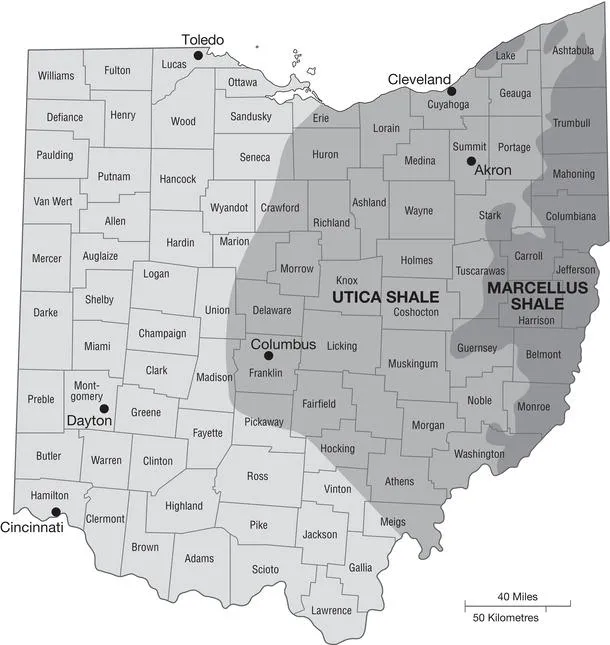
At the end of the Ordovician, an ice age in the southern hemisphere (where Ohio was then located) reduced sea levels, making Ohio into dry land by the beginning of the Silurian period (440 million years ago). Warm shallow seas returned and by the middle Silurian they deepened and blanketed all but the most southeastern part of the state. By the late Silurian the seas abated again and had all but dried up by the time the Devonian period began (about 410 million years ago). The retreating Silurian seas left behind vast beds of halite (salt) and gypsum as well as more layers of limestone and shale. By the early Devonian period most of Ohio and parts of Kentucky and Indiana were part of a large island surrounded by tropical waters that lapped the eastern Ohio shore. The first true land plants grew in Ohio at this time. By the middle Devonian period shallow seas once again covered Ohio. The remnants of the shells and large coral reefs of this period became another thick layer of limestone this time with numerous fossils of fish embedded in it. By the late Devonian period, increased volcanic activity from mountain building to the east not only blanketed the area with toxic ash but also created fast-flowing rivers that dumped immense amounts of mud into the increasingly stagnant and lifeless late Devonian sea. These deposits make up the Ohio Shale, which also contains numerous iron concretions and pockets of natural gas (see Figure 1.2 for Ohio’s major shale regions). Silurian and Devonian strata make up much of today’s surface stone of western Ohio.
Mississippian and Pennsylvanian periods
The ebb and flow of prehistoric seas continued for the rest of the Paleozoic era. The increasingly muddy waters of the late Devonian period continued into the early Mississippian (starting about 360 million years ago) and then eventually gave way to more silt and sand deposits as the period progressed. The early Mississippian mud turned into the Bedford Shale, while the later sandy deposits became the Black Hand and Berea sandstones. A late Mississippian sea laid down more limestone before retreating at the end of the period. Land plants became increasingly abundant during the periods of sea retreat, a trend that continued into the Pennsylvanian period (325–286 million years ago). As the Mississippian sea retreated, much of eastern Ohio became a large delta onto which flowed the pebbly erosion from mountains to the north and east. This eventually created an abundant rock known as the Sharon Conglomerate. In time, a vast tropical swamp forest stretched throughout much of the Pennsylvania, Ohio, West Virginia, Kentucky, and Indiana areas, leaving millions of years of organic deposits. These forested swamps were periodically overtaken by advancing seas, which buried the plant and animal material under layers of sand and clay, with the cycle repeating many times. The marine-formed strata became new layers of limestone, the silica-rich Middle Pennsylvanian Vanport Limestone in particular, that formed the famous Flint Ridge flint. The Upper Mercer Limestone of the Pottsville formation, which created the prized black flint from Coshocton County, also came from this period. As the layers from the advancing and retreating seas accumulated over the course of the Pennsylvanian period, they created enough pressure on lower strata to convert the trapped swamp forest-life deposits into coal.
Figure 1.2 The extent of shales in Ohio.
Source: Courtesy of the State of Ohio Environmental Protection Agency
Most of the surface rocks seen today in eastern Ohio were created during the Late Pennsylvanian period. Known as “the coal measures,” these alternating layers of shales, sandstones, limestones, clays, and coals—up to 2,000 feet thick in some places—suggest numerous episodes of the swamp forest-to-sea cycle. The seas retreated from nearly all of Ohio permanently at the end of the Pennsylvanian and, apart from a narrow band in extreme southeastern Ohio that was a coastal swamp during the Permian period (286–248 million years ago), no further geological strata developed in what became Ohio. However, over the next quarter of a billion years many other processes altered the Ohio landscape significantly.
Topography
Several major factors since the Permian period helped to create Ohio’s current landscape. The most significant of these have been orogeny (mountain building) and glaciation (the formation and movement of glaciers) and their effects that include erosion, river and lake formation, and the creation of soil through the deposition of material brought by glaciers (glacial till) and vast amounts of wind-blown silt that accompanied them (loess).
Allegheny uplift
To the east of what is now Ohio the tectonic plate that carried most of North America began to collide with another one as early as the Late Mississippian period to help create the supercontinent of Pangea. Over the next several tens of millions of years these plates ground together, folding and thrusting up the earth at its boundaries to create the Allegheny Mountains. These were originally much higher and rockier. This process continued until the Late Permian period when what is now the North American continent began to move north from its traditionally tropical latitudes on its way to its present location. Although the mountain formation did not occur in what is now Ohio the process significantly altered Ohio’s topography. First, the tectonic collision uplifted the entire area, which helped to cause the final retreat of the seas that had periodically flooded Ohio during most of the Paleozoic era. Today, Ohio’s mean elevation is 850 feet (259 meters) above sea level. Ohio’s lowest point (on the Ohio River where it exits the state) has an elevation of 455 feet (139 meters). Second, over the course of the Mesozoic and Cenozoic eras that followed the Paleozoic, the uplifted plateaus of eastern Ohio began to receive rivers and erosion from the new mountain chain to the east, as well as experience its own weathering and erosion. These forces created the hilly Appalachian Plateau, the characteristic topography of eastern Ohio.
Teays River
At some point during the Tertiary period of the Cenozoic era (roughly 65 to 2 million years ago) a great river rose on the western side of the Appalachians in what is now western North Carolina near Blowing Rock and flowed north and west. Geologists call this river and its tributaries the Teays River system. At one it time drained much of the east-central United States, including Ohio. Entering Ohio in Scioto County and proceeding north, the Teays then proceeded west through the state to Mercer County on the Indiana Border, ultimately flowing into an arm of the Gulf of Mexico that at one time extended up the current Mississippi Valley to southern Illinois (some geologists suggest that the river instead continued to flow north to an extinct river system where Lake Erie is now). As wide as two miles in places, this river cut a broad swath through the Ohio countryside and carved a number of flat-bottomed valleys, some of which are still the beds of contemporary rivers in the southern part of the state. Now buried as much as 500 feet deep in places in northern Ohio, the old Teays riverbed still serves as an aquifer supplying well water to communities living above it.
Glaciation
The reason there is no Teays River today—and indeed the reason why there is an Ohio River instead—can be attributed to the last major event that dramatically affected Ohio’s topography: the advance and retreat of glaciers. By the late Cenozoic period the North American continent had more or less arrived at its present latitude, and the climate was considerably cooler than it had been for most of the previous eon. In addition, by the middle of the Pleistocene period (about 1.8 million to 10 thousand years ago) the climate of the entire earth began to cool, and ice caps began to form on earth’s polar regions. Around 300,000 years ago, the Laurentide Ice Sheet to the north began a series of glacial advances southward and retreats northward that did not cease in Ohio until about 14,000 years ago. Glaciers are huge juggernauts of ice that move very slowly but scour and rearrange the earth’s surface dramat...