![]()
1
Terrestrial Hydrometeorology and the Global Water Cycle
Introduction
Water is not the most common molecule on planet Earth, but it is the most important. Life started in water and cannot survive long without it; it makes up approximately 60% of animal tissue and 90% of plant tissue. The most important greenhouse gas in the atmosphere is water vapor. If it were not present the Earth’s surface temperature would be several tens of degrees cooler, and predicting the effect of changing atmospheric water content is arguably the greatest challenge facing those who seek to predict future changes in climate. It is the continuous cycling of water between oceans and continents that sustains the water flows over land which in large measure determine the evolution of landscapes. The ability of water to store energy in the form of latent heat or because of its high thermal capacity means that moving water as vapor or fluid transports large quantities of energy around the globe. The presence of frozen water on land as snow also has a major impact on whether energy from the Sun is captured at the Earth’s surface or is reflected back to space. In fact, it is hard to think of a process or phenomenon important to the way our Earth behaves in which the presence of water is not significant.
Hydrologists originally considered hydroclimatology to be ‘the study of the influence of climate upon the waters of the land’ (Langbein 1967). This definition is now outdated because it implies too passive a role for land surface influences on the overlying atmosphere. The atmosphere is driven by energy from the Sun, but about half of this energy enters from below, via the Earth’s surface. Whether that surface is ocean or land matters and, if land, the nature of the land surface also matters because this affects the total energy input to the atmosphere and the form in which it enters. In practice, the science of hydroclimatology is often concerned with understanding the movements of energy and water between stores within the Earth system. Because climate is the time-average of weather, strictly speaking hydroclimatology emphasizes the time-average movement of energy and water. Such movement occurs in two directions, both out of and into the atmosphere. Consequently, the present text is motivated not only by the need to understand the global and regional scale atmospheric features that affect the weather in a specific catchment, but also to understand how the surface-atmosphere exchanges that operate inside a catchment contribute along with those from nearby catchments to determine the subsequent state of the atmosphere downwind.
Broadly speaking, hydrometeorology differs from hydroclimatology in much the same way that meteorology differs from climatology. Hydrometeorologists therefore tend to be more interested in activity at shorter time scales than hydroclimatologists. They are particularly concerned with the physics, mathematics, and statistics of the processes and phenomena involved in exchanges between the atmosphere and ground that typically occur over hours or days. Sometimes these short-term features are described statistically. Hydrometeorologists may, for example, analyze precipitation data to compute the historical statistics of intense storms and flood hazards. However, hydrometeorologists are also interested in seeking basic physical understanding of surface exchanges of water and energy. This commonly involves the study of processes that act in the vegetation covering the ground, or the soil and rock beneath the ground, or in lower levels of the atmosphere where most atmospheric water vapor is found. The present text includes some description of the statistical approaches used in hydrometeorology but gives greater prominence to providing an understanding of fundamental hydrometeorological processes.
Water in the Earth system
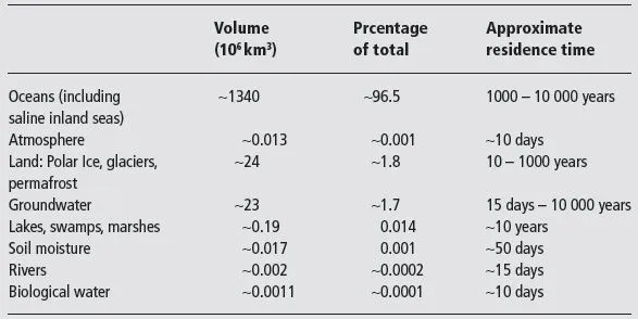
Although there have been several studies which have attempted to quantify where water is to be found across the globe, the magnitude of the Earth’s water reservoirs and how much water flows between these reservoirs still remains poorly defined. Table 1.1 gives estimates of the size of the eight main reservoirs together with the approximate proportion of the entire world’s water stored in each reservoir and an estimate of the turnover time for the water. The magnitude of the groundwater reservoir and the associated residence time is complicated by the fact that a large proportion of the water in this reservoir is ‘fossil water’ stored in deep aquifers which were created over thousands of years by slow geo-climatic processes. The amount of such fossil water stored is very difficult to estimate globally. Defining a residence time for oceans is also complicated. This is because oceans usually have a fairly shallow layer of surface water on the order of 100 m deep that interacts comparatively readily with the atmospheric and terrestrial reservoirs, but this layer overlies a much deeper, slower moving, and more isolated reservoir of saline water.
Table 1.1 Estimated sizes of the main water reservoirs in the Earth system, the approximate percentage of water stored in them and turnover time of each reservoir (Data from Shiklomanov, 1993).
Clearly oceans are by far the largest reservoir of water on Earth, which means that a vast proportion of water on the Earth is salt water. The majority of Earth’s freshwater supply is currently stored in the polar ice caps, as glaciers or permafrost, or as groundwater. Freshwater lakes, rivers, and marshes contain only about 0.01% of Earth’s total water. The water present in the atmosphere is very small indeed, only about 0.001%. However, the water exchanged between this atmospheric reservoir and the oceanic and land reservoirs is comparatively large, on the order of 100 km3 per year for land and 400 km3 per year for oceans. Consequently, there is a rapid turnover in atmospheric water and the atmospheric residence time is low.
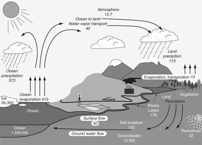
Figure 1.1 illustrates the annual average hydrological cycle for the Earth as a whole, together with an alternative set of estimates of water stores made by combining observations with model-calculated data. It is clear that the simple concept of a hydrological cycle that merely involves water evaporating from the ocean, falling as precipitation over land then running back to the ocean is a poor representation of the truth. There are also substantial hydrological cycles over the oceans which cover about 70% of the globe, and over the continents which cover the remainder, as well as water exchanged in atmospheric and river flows between these two.
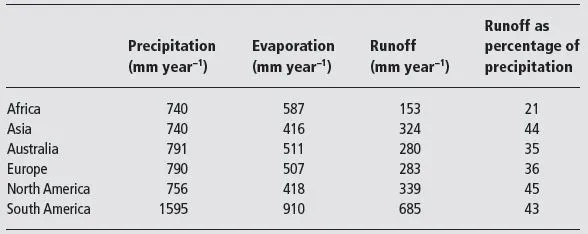
On average there is a net transfer from oceanic to continental surfaces because the oceans evaporate about 413 × 103 km3 yr-1 of water, which is equivalent to about 1200 mm of evaporation, but they receive back only about 90% of this as precipitation. Some of the water evaporated from the ocean is therefore transported over land and falls as precipitation, but on average about 65% of this terrestrial precipitation is then re-evaporated and this provides some of the water subsequently falling as precipitation elsewhere over land. On average about 35% of terrestrial precipitation returns to the ocean as surface runoff, but the proportion of terrestrial precipitation that is re-evaporated and the proportion leaving as surface runoff varies significantly both regionally and with season. Area-average runoff in the semi-arid south western USA is, for example, commonly just a few percent. When averaged over large continents and over a full year, variations in the fraction of precipitation leaving as runoff are less. Table 1.2 gives an example of the estimated annual water balance for the continents (Korzun 1978). Runoff ratios in the range of 35 to 45% are the norm, but the extensive arid and semi-arid regions of Africa reduce average runoff for that continent. Fractional runoff in the form of icebergs from Antarctica is hard to quantify but may be 80% because sublimation from the snow and ice covered surface is low.
Table 1.2 Estimated continental water balance (Data from Korzun, 1978).
Components of the global hydroclimate system
Understanding the hydroclimate of the Earth does not merely require knowledge of hydrometeorological process in the atmosphere. Several different components of the Earth system interact to control the way near-surface weather variables vary in time and space. It is helpful to recognize the nature of these components from the outset and to appreciate in general terms how they influence global hydroclimatology. For this reason we next consider salient features of the atmosphere, hydrosphere, cryosphere, and lithosphere, biosphere, and anthroposphere.
Atmosphere
The air surrounding the Earth is a mixture of gases, mainly (~80%) nitrogen and (~20%) oxygen, but also other minority gases such as carbon dioxide, ozone, and water vapor which have an importance to hydroclimatology not adequately reflected by their low concentration. Compared to the diameter of the Earth (~20,000 km), the depth of the atmosphere is small. The density of air changes with height but about 90% of the mass of the atmosphere is within 30 km and 99.9% within 80 km of the ground.
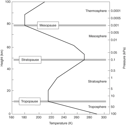
The atmosphere is (almost) in a state of hydrostatic equilibrium in the vertical, with dense air at the surface and less dense air above; there is an associated change in pressure. The temperature of the air changes with height in a very distinctive way and this can be used to classify different layers or ‘spheres’. Figure 1.2 shows the vertical profile of air temperature in the US Standard Atmosphere (US Standard Atmosphere, 1976) as a function of height and atmospheric pressure. Starting from the surface, the main layers are the troposphere, stratosphere, mesosphere, and thermosphere, separated by points of inflection in the vertical temperature profile that are called ‘pauses’. Near the ground, air temperature falls quickly with height for reasons which are discussed in more detail later. Higher in the atmosphere the air is warmed by the release of latent heat when water is condensed in clouds and, in the upper stratosphere, it is also warmed by the absorption of a portion of incoming solar radiation. There is then further cooling through the mesosphere, but some further warming at the very top of the atmosphere where most of the Sun’s gamma rays are absorbed.
The relative concentration of atmospheric nitrogen, oxygen and other inert gases is uniform with height, but most ozone is found in the middle atmosphere where it absorbs ultraviolet radiation to warm the air. The concentration of carbon dioxide falls away in the mesosphere and the vast majority of atmospheric water vapor is found within 10 km of the ground, mainly in the lower levels of the troposphere. The fact that water vapor content falls quickly with height is strongly related to the fall in temperature with height. The amount of water vapor that air can hold before becoming saturated is less at lower temperatures and water is precipitated out as water droplets or ice particles in clouds. The concentrations of liquid and solid water in clouds and that of other atmospheric constituents, including solid particles such as dust particles, sulfate aerosols, and volcanic ash, all vary substantially both in space and with time.
As previously mentioned, the residence time for water in the atmosphere is short, about 10 days. In fact, a comparatively short response time is a general feature of the atmosphere that distinguishes it from the other components of the climatic system. Air has a relatively large compressibility and low specific heat and density compared to the fluids and solids that make up the hydrosphere, cryosphere, lithosphere and biosphere. Because air is more fluid and unstable, any perturbations generated by changes in the inputs that drive the atmosphere typically decay with time scales on the order of days to weeks.
Differential heating by the Sun causes movement in the atmosphere that is complicated by the rotation of the Earth, the Earth’s orbit around the Sun, and inhomogeneous surface conditions. Consequently, the air in the troposphere undergoes large-scale circulation which, on average, is organized at the global scale. There are substantial perturbations within this circulation...