Innsbrucks architektonische Geschichte und Gegenwart entdecken: 9 Jahrhunderte, 264 Bauwerke, 300 ArchitektInnen.Vom Goldenen Dachl über die Triumphpforte, die Nordkettenbahn und die Bergiselschanze bis zum Haus der Musik - Innsbrucks abwechslungsreiche Architekturlandschaft lädt zum Entdecken ein! Der Architekturführer Innsbruck bietet erstmals einen Leitfaden durch die Architektur- und Stadtbaugeschichte der Alpenstadt und reicht vom römischen Lager Veldidena, der mittelalterlichen Marktsiedlung und herzoglichen Renaissance- und Barockresidenz bis in die Gegenwart der modernen Tiroler Landeshauptstadt. Die rund tausendjährige Architekturgeschichte Innsbrucks reicht damit vom ältesten erhaltenen sakralen Baudenkmal über die bedeutendsten historischen Bauten bis hin zu den jüngsten Entwicklungen und modernen Architektur-Highlights.Das Archiv für Baukunst stellt in diesem Stadtführer mehr als 260 architektonische Kunstwerke aus allen Bauepochen vor und behandelt dabei sowohl Tradition und Vergangenheit als auch Moderne und Gegenwart. Der zweisprachige Architekturführer Innsbruck ist großzügig ausgestattet mit zahlreichen Fotografien, Grundrissen, Schnitten und Lageplänen. Mit seinen Übersichtsplänen lädt er dazu ein, auf abwechslungsreichen Spaziergängen die architektonische Vielfalt Innsbrucks zu erwandern, und bietet kompakte Infos zu Sehenswürdigkeiten und architektonischen Geheimtipps abseits der gewohnten Pfade. Für Stadtentdecker, Architekturinteressierte und neugierige Bewohner, die ihre Landeshauptstadt mit einem neuen Blick erleben möchten!- wissenswerte Hintergründe: Siedlungs- und Stadtbaugeschichte, Umgang mit dem architekturhistorischen Erbe- mit Rundgängen durch alle Stadtteile Innsbrucks- einfache Orientierung vor Ort dank Eintragung aller Objekte in übersichtliche Stadtpläne und farbliche Differenzierung der einzelnen Stadtteile- ein praktischer Stadtführer in ansprechendem Design, in handlichem Format, mit Lese- und Gummiband
eBook - ePub
Architekturführer Innsbruck / Architectural guide Innsbruck
- 280 Seiten
- German
- ePUB (handyfreundlich)
- Über iOS und Android verfügbar
eBook - ePub
Architekturführer Innsbruck / Architectural guide Innsbruck
Über dieses Buch
375,005 Studierende vertrauen auf uns
Zugang zu über 1 Million Titeln zu einem fairen monatlichen Preis.
Mit unseren Lerntools kannst du noch effizienter lernen.
Information
Thema
ArchitekturFÜHRER
DURCH
DIE STADT
GUIDE
THROUGH
THE CITY
ALTSTADT & INNERE STADT
(MARIAHILF, ST. NIKOLAUS, SAGGEN, DREIHEILIGEN, SCHLACHTHOF)
Auf der linken Innseite in Mariahilf und St. Nikolaus liegt die erste durch die Markgrafen von Andechs-Meranien gegründete, als Ynbruggen bezeichnete Marktsiedlung. Am Brückenkopf bilden vier- bis fünfgeschoßige Bürgerhäuser und Ansitze eine abwechslungsreiche, erkergeschmückte Front zum Inn (Nr. 92). Innabwärts stehen bescheidenere Bauten wie Handwerksbetriebe, Gießereien und Ziegeleien. Städtebauliche Akzente setzen die frühbarocke Mariahilfkirche (Nr. 91) und die neogotische Pfarrkirche St. Nikolaus (Nr. 95).
Die Ausdehnung der mittelalterlichen Altstadt auf der rechten Innseite ist an dem Straßenzug von Marktgraben, Burggraben, Rennweg, Herrengasse und Herzog-Otto-Straße, der dem Verlauf der Stadtmauer entspricht, noch ablesbar. Innabwärts der Ottoburg (Nr. 10) sind noch Abschnitte dieser Stadtmauer zu sehen. Drei Haupttore führten in die Stadt: Im Westen an der Brücke das durch eine Burg gesicherte Inntor (abgetragen 1790), im Süden das Vorstadttor (abgetragen 1765) und im Osten am Ende der Hofgasse das Rumer Tor, das im Südrondell der Hofburg (Nr. 12) aufgegangen ist.
Im Inneren der Altstadt bildet die abgewinkelte Herzog-Friedrich-Straße mit der Hofgasse und der Pfarrgasse ein größeres, die Kiebach-/Seilergasse ein kleineres, die Stadtstruktur prägendes Achsenkreuz. An der Herzog-Friedrich-Straße liegen mit dem Unteren Stadtplatz am Inn und dem zentralen Oberen Stadtplatz nicht nur die wichtigsten Märkte, sondern auch bedeutende Bauten: das Alte Regierungsgebäude (Nr. 11), der Neuhof mit dem Goldenen Dachl (Nr. 1) und das Alte Rathaus mit dem Stadtturm (Nr. 4). Nördlich schließt sich der Dom St. Jakob (Nr. 21) an, der ausgedehnte Komplex der Hofburg (Nr. 12) bildet die Nordostecke der Altstadt.
Das Straßenbild wird dominiert durch vier- bis fünfgeschoßige Bürgerhäuser und Ansitze, deren Kern zumeist auf das 15./16. Jh. zurückgeht. Die mit Erkern ausgestatteten Fassaden wurden im 17./18. Jh. neu gefasst und zum Teil reich dekoriert. Die Häuser haben schmale Grundrisse aus Vorder- und Hinterhaus (Stöckl) mit mittigem Hof und Treppenhaus. Die stadtbildprägenden Lauben wurden ab 1420 eingebrochen, in Ausnahmefällen wie am Gasthof Goldener Adler auch vorgebaut. Die zahlreichen Strebepfeiler aus Höttinger Breccie sind Sicherungsmaßnahmen nach den Erdbeben von 1572 und 1689.
Eine erste Vorstadt im Süden an der heutigen Maria-Theresien-Straße, die etwa bis zum Alten Landhaus (Nr. 61) reichte, wurde schon 1281 erwähnt. Bis ins 16. Jh. wuchs das zunächst nur locker bebaute Gebiet bis zur Triumphpforte (Nr. 127). Im 17./18. Jh. wurden barocke Adels palais errichtet und die Maria-Theresien-Straße zu einem geschlossenen Straßenzug ausgebaut; einzelne Bauten wurden im 19. Jh. historistisch überformt. Seit 2010 hat der umstrittene Bau des Kaufhaus Tyrol den Maßstab der Straße nachhaltig verändert (Nr. 66).
Im Osten ließ Erzherzog Ferdinand II. die Hofburg (Nr. 12) erweitern und einen der ersten Renaissancegärten im deutschsprachigen Raum anlegen; mit dem Ballhaus, dem Theater und der Hofreitschule wurden weitere höfische Großbauten errichtet, deren Nachfolger, das Landestheater (Nr. 20), das Kongressgebäude (Nr. 23) und das Haus der Musik (Nr. 18) heute ein veritables Kulturquartier bilden; hier befindet sich auch der Kopfbahnhof der neuen Hungerburgbahn (Nr. 27).
Auch an der Universitätsstraße änderte sich mit dem Bau von Hofkirche (Nr. 15) und Franziskanerkloster (Nr. 17) der Maßstab der Bebauung. Mit seinem Vorplatz setzte der Neubau der Jesuitenkirche (Nr. 41) im 17. Jh. einen klaren städtebaulichen Akzent. Nordöstlich der Altstadt liegt der Saggen, ein ehemaliger Weidegrund. Ab 1886 entsteht hier ein repräsentatives Villenviertel in allen Spielarten des Historismus. Ende des 19. Jh. wird auch der östliche Teil bis zur Bahnstrecke als Blockrandbebauung mit Zinshäusern bebaut; an den Rändern entstehen großvolumige, freistehende Einzelbauten wie die Messehalle (Nr. 100), die Direktion der Bundesbahnen (Nr. 103), das ehemalige Waisenhaus (Nr. 104) und die Handelsakademie (Nr. 108). KT
On the left side of the Inn, in Mariahilf and St. Nikolaus, is the location of the first market settlement, designated as Ynbruggen, and founded by the margraves of Andechs-Merania. On the bridgehead, four to five-storey middle-class houses and residences form a varied front to the Inn. The buildings are mostly Late-Gothic with bays; the façades were mantled in the 18th/19th century (no. 92). Down the Inn, there are more modest buildings, where handicraft businesses, foundries and brick factories can be found. The early Baroque Mariahilfkirche (no. 91) and the Neo-Gothic parish church of St. Nikolaus (no. 95) set urban architectural accents.
The extension of the medieval old town on the right-hand side of the Inn is still visible in the street profiles of Marktgraben, Burggraben, Rennweg, Herrengasse and Herzog-Otto-Straße. Their course corresponds to the course of the city wall. Sections of this city wall can still be seen down the Inn from the Ottoburg (no. 10). Three main gates led into the city: to the west, the Inn gate (dismantled in 1790) at the bridge, secured by a castle, the suburban gate (dismantled in 1765) to the south and to the east the Rumer gate, which has merged into the turret of the Hofburg (no. 12) at the end of the Hofgasse.
Within the old town, the angled Herzog-Friedrich-Straße with the Hofgasse and the Pfarrgasse forms a larger axis of coordinates, the Kiebach-/Seilergasse a smaller one, characterising the urban structure. The Herzog-Friedrich-Straße, is not only the location of the most important markets, but also important buildings on the Unterer Stadtplatz at the Inn and the central Oberer Stadtplatz: the Altes Regierungsgebäude (no. 11), the Neuhof mit dem Goldenen Dachl (no. 1) and the Altes Rathaus with the Stadtturm (no. 4). To the north, there is the cathedral St. Jakob (no. 21); the extensive complex of the Hofburg (no. 12) forms the northern part of the old town.
The appearance of the streets is dominated by four- to five-storey middle-class houses and residences, the core of which mostly date back to the 15th/16th century. The façades, that were equipped with bays, were reworked in the 17th/18th century and to some extent richly decorated. The houses have narrow ground plans consisting of front-facing and rear-facing buildings (Stöckl) with a central courtyard and a staircase. The pergolas that were forming a landmark were broken down from 1420 and, also, in exceptional cases, built onto the exterior like the Gasthof Goldener Adler. The numerous buttresses made of Hötting breccia are securing measures after the earthquakes of 1572 and 1689.
A first suburb in the south on today’s Maria-Theresien-Straße, which led approximately to the Altes Landhaus (no. 61), was mentioned already in 1281. Until the 16th century, the initially only loosely developed area grew up to the Triumphpforte (no. 127). In the 17th/18th century, Baroque noble palaces were erected and Maria-Theresien-Straße was built into a closed street; individual buildings were historically mantled in the 19th century. Since 2010, the controversial Kaufhaus Tyrol (no. 66) has strongly changed the scale of the street.
In the east, Archduke Ferdinand II commissioned the extension of the Hofburg (no. 12) and laid out one of the first Renaissance gardens in the German-speaking area; with the ballroom building, the theatre and the Hofreitschule, further large courtly buildings were erected; their successors, the Landestheater (no. 20), the Kongressgebäude (no. 23) and the Haus der Musik (no. 18) form a veritable cultural quarter today; here you can also find the rail head of the new Hungerburgbahn (no. 27). Also, on Universitätsstraße, the construction of Hofkirche (no. 15) and Franziskanerkloster (no. 17) changed the scale of the building development. With its forecourt, the new construction of the Jesuitenkirche (no. 41) in the 17th century gave a clear urban accent.
The Saggen, a pasture ground originally belonging to the Stift Wilten, is located to the northeast of the old town. From 1886 onwards, a representative villa quarter was built; the mainly three-storey buildings show all varieties of the Historicism. At the end of the 19th century, the eastern part up to the railway track was also built as perimeter development with apartment buildings; on the edges, large-scale, freestanding individual buildings such as the Messehalle (no. 100), the Bahndirektion (no. 103), the former Waisenhaus (no. 104) and the Handelsakademie (no. 108) emerged.
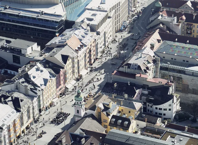
Innsbruck, Maria-Theresien-Straße

1 GOLDENES DACHL
Herzog-Friedrich-Straße 15
um 1420; um 1500; bis 1621; 1780; 1822; 1996
Architekt unbekannt; Niclas Türing der Ältere
Architekt unbekannt; Niclas Türing der Ältere
Als neue Residenz der Tiroler Habsburger ließ Herzog Friedrich IV. den Neuhof um 1420 auf den Grundmauern zweier älterer Bürgerhäuser errichten. Bis 1621 konnte der seit Ende des 15. Jahrhunderts als Sitz der Hofkammer genutzte Bau durch Ankauf benachbarter Häuser sowie Neubau des Turmes im Innenhof zu einem mehrflügeligen Komplex ausgebaut werden. Durch die Umnutzung zur Kaserne (1780) und zum Mietshaus (1822) wurde das Innere fast vollständig verändert und das Gebäude erhielt seine heutige Fassade. Zum ursprünglichen Bestand des Neuhofs zählt heute das um 150...
Inhaltsverzeichnis
- Cover
- Titel
- Inhaltsverzeichnis
- Vorbemerkung / Preliminary remarks
- Siedlungsgeschichtlicher Überblick / History of settlements
- Stadtbaugeschichte / History of urban development
- Kritische Bemerkungen zur baulichen Entwicklung Innsbrucks nach 1945 und dem Umgang mit dem architekturhistorischen Erbe /
- Critical remarks on the structural development of Innsbruck after 1945 and on dealing with the architecture-historical heritage
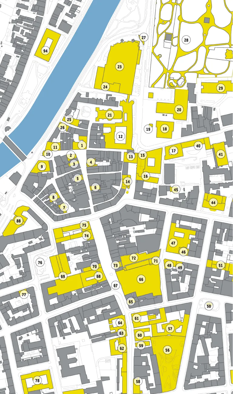
- Übersichts-Stadtplan / Map overview
- Führer durch die Stadt / Guide through the city
- Register / Indices
- Die AutorInnen
- Impressum
Häufig gestellte Fragen
Ja, du kannst dein Abo jederzeit über den Tab Abo in deinen Kontoeinstellungen auf der Perlego-Website kündigen. Dein Abo bleibt bis zum Ende deines aktuellen Abrechnungszeitraums aktiv. Erfahre, wie du dein Abo kündigen kannst
Nein, Bücher können nicht als externe Dateien, z. B. PDFs, zur Verwendung außerhalb von Perlego heruntergeladen werden. Du kannst jedoch Bücher in der Perlego-App herunterladen, um sie offline auf deinem Smartphone oder Tablet zu lesen. Erfahre, wie du Bücher herunterladen kannst, um sie offline zu lesen
Perlego bietet zwei Abopläne an: Elementar und Erweitert
- Elementar ist ideal für Lernende und Profis, die sich mit einer Vielzahl von Themen beschäftigen möchten. Erhalte Zugang zur Basic-Bibliothek mit über 800.000 vertrauenswürdigen Titeln und Bestsellern in den Bereichen Wirtschaft, persönliche Weiterentwicklung und Geisteswissenschaften. Enthält unbegrenzte Lesezeit und die Standardstimme für die Funktion „Vorlesen“.
- Pro: Perfekt für fortgeschrittene Lernende und Forscher, die einen vollständigen, uneingeschränkten Zugang benötigen. Schalte über 1,4 Millionen Bücher zu Hunderten von Themen frei, darunter akademische und hochspezialisierte Titel. Das Pro-Abo umfasst auch erweiterte Funktionen wie Premium-Vorlesen und den Recherche-Assistenten.
Wir sind ein Online-Lehrbuch-Abo, bei dem du für weniger als den Preis eines einzelnen Buches pro Monat Zugang zu einer ganzen Online-Bibliothek erhältst. Mit über 1 Million Büchern zu über 990 verschiedenen Themen haben wir bestimmt alles, was du brauchst! Erfahre mehr über unsere Mission
Achte auf das Symbol zum Vorlesen bei deinem nächsten Buch, um zu sehen, ob du es dir auch anhören kannst. Bei diesem Tool wird dir Text laut vorgelesen, wobei der Text beim Vorlesen auch grafisch hervorgehoben wird. Du kannst das Vorlesen jederzeit anhalten, beschleunigen und verlangsamen. Erfahre mehr über die Funktion „Vorlesen“
Ja! Du kannst die Perlego-App sowohl auf iOS- als auch auf Android-Geräten nutzen, damit du jederzeit und überall lesen kannst – sogar offline. Perfekt für den Weg zur Arbeit oder wenn du unterwegs bist.
Bitte beachte, dass wir Geräte, auf denen die Betriebssysteme iOS 13 und Android 7 oder noch ältere Versionen ausgeführt werden, nicht unterstützen können. Mehr über die Verwendung der App erfahren
Bitte beachte, dass wir Geräte, auf denen die Betriebssysteme iOS 13 und Android 7 oder noch ältere Versionen ausgeführt werden, nicht unterstützen können. Mehr über die Verwendung der App erfahren
Ja, du hast Zugang zu Architekturführer Innsbruck / Architectural guide Innsbruck von Christoph Hölz,Klaus Tragbar,Veronika Weiss im PDF- und/oder ePub-Format sowie zu anderen beliebten Büchern aus Architektur & Architektur Allgemein. Aus unserem Katalog stehen dir über 1 Million Bücher zur Verfügung.