![]()
Chapter 1
Threshold
The prize is the pleasure of finding the thing out.
—Physicist Richard Feynman, 1918–1988
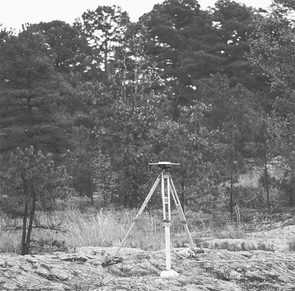
Stretched out on a sun-warmed rock, I admired the hawks circling lazily in the bright-blue sky. It was a perfect October day in 1997 in Petit Jean State Park, high in Arkansas’s Ozark Mountains. About 50 yards away, I could see a five-foot yellow-and-orange wooden tripod topped by a shiny metal disk that looked like a large Frisbee. The disk was an antenna receiving radio signals from Global Positioning System (GPS) satellites orbiting thousands of miles above the earth (fig. 1.1). An expensive, high-precision GPS receiver about the size of a personal computer recorded the signals and used them to find the antenna’s latitude and longitude to incredible accuracy.
In the early morning chill, I’d carefully set up the tripod over a metal marker drilled into solid rock. Doing this involved sighting through a lens to position the tripod over the marker and adjusting the tripod legs to make sure the antenna was level. This complicated sequence felt like an intelligence test that I’d slowly and only barely passed.
The GPS receiver was doing a very simple thing—measuring its location—using incredibly complicated space technology. Fellow geologists and I had installed 24 markers like this one over a large area in the central U.S. We’d measured their positions in 1991 and 1993 and were now doing it again.
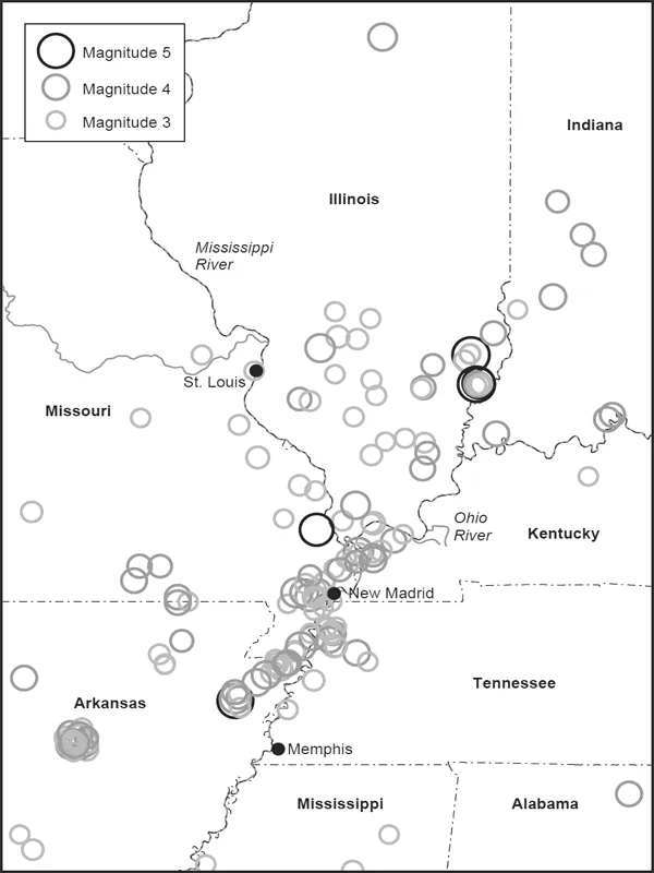
Our goal was to learn more about the mysterious zone of earthquakes called the New Madrid seismic zone. It’s named after the town of New Madrid, pronounced “MAD-red,” in the area of southeastern Missouri known as the “Bootheel.” The zone includes parts of Missouri, Arkansas, Tennessee, Kentucky, Illinois, and Indiana. In 1811 and 1812, large earthquakes here shook the central U.S., and small earthquakes continue in the zone today. A map of the recent small earthquakes shows some major patches, which we think are mostly aftershocks of the past large earthquakes, surrounded by a diffuse “cloud” (fig. 1.2).
FIGURE 1.1 GPS antenna at Petit Jean State Park.
These earthquakes are interesting because they’re in a strange place. Most big earthquakes happen at the boundaries between the great rock plates that slide around on the earth’s surface. For example, the San Andreas fault in California is part of the boundary between the Pacific and North American plates. In contrast, the New Madrid seismic zone is a less active earthquake zone in the middle of the continent, within the North American plate.
Geologists know surprisingly little about what’s going on here. We don’t know why the earthquakes occur; when they started; if, when, and where future large earthquakes will occur; how serious a danger they pose; or how society should confront them. A big part of the problem is that because large earthquakes here are much rarer than in many other seismic zones, we don’t yet have the data to answer these questions. This situation made New Madrid a perfect place to use the new GPS method that was quickly becoming a powerful tool for earthquake studies around the world.
FIGURE 1.2 Locations of earthquakes between 1975 and 2008 in and around the New Madrid seismic zone. (After University of Memphis)
Because we were recording GPS data at each site for 10 hours a day over three days, I had a lot of time in a beautiful place to think about what we were learning. Already, it looked like we were on the threshold of something big. Earthquakes happen when slow motions stored up in the earth over hundreds or thousands of years are suddenly released. We had expected to see the sites moving. Surprisingly, we weren’t seeing that, but our first two surveys weren’t enough to be sure. This survey would settle the question.
A few months later, graduate student Andy Newman, who was analyzing the survey data for his doctoral thesis, brought his findings to my office at Northwestern University. The result was clear. To the accuracy of the GPS measurements, the ground across the earthquake zone wasn’t moving.
To tell if a monument in the ground is moving, geologists measure its position at different times and see if it changes. Because every measurement has some uncertainty, we look to see whether the position has changed by more than that uncertainty. It’s like the way you tell if a diet is working. You know that there’s some uncertainty in the scale because weighing yourself several times gives slightly different answers. The question is whether over time your weight changes by more than that uncertainty.
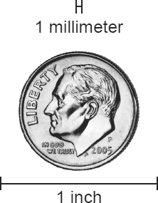
The GPS systems used in geology are so incredibly precise that we measure the motions of markers in the ground in millimeters—1/1000 of a meter—per year. Because a meter is 39.37 inches, a millimeter is about 1/25 of an inch. As figure 1.3 shows, that’s about the size of the bigger letters on a dime. If the ground moves that much in a year, GPS can detect it.
This precision lets geologists measure the slow movements of the earth. That makes GPS the most important new tool we’ve gotten in the past 20 years for earthquake studies. For example, GPS shows that the motion across California’s San Andreas fault is about 36 millimeters per year. Most of the time, the fault is “locked” by the friction between the rocks on either side, so the motion is stored up in the rock. Eventually, the stored motion overcomes the friction, and the fault moves in a big earthquake. This happens about every hundred years, so in seconds the fault moves about 3,600 millimeters, or about 12 feet!
FIGURE 1.3 GPS measurements can tell if a point on the earth moves by more than a millimeter—about 1/25 of an inch—in a year. That’s the height of a capital letter on a dime.
Our GPS data for New Madrid didn’t show any motion. Specifically, they showed that the ground was moving less than 2 millimeters per year. That’s at least 18 times more slowly than the San Andreas. We were also pretty sure that the number would get much smaller if we kept measuring for a longer time. Already it was a lot slower than we’d expect if a big earthquake were coming any time soon. I thought of the joke in which a tourist asks a Maine farmer “Does this road go to Bangor?” and is told “Nope, stays right where it is.”
During the next few months, all of us in the project talked at length about what the lack of motion might mean. Conventional wisdom was that the New Madrid area faced a major earthquake risk. The U.S. government claimed that this risk was as high as in California and was pressuring communities to make expensive preparations.
The GPS data showed that these common ideas about the New Madrid seismic zone needed serious rethinking. All of us in the project were excited. Although as scientists we’re trying to solve the earth’s mysteries, much of our effort actually goes into day-to-day chores like trying to fix computer programs. Most of the time we do routine studies and find answers that aren’t too surprising. The most exciting times are when a project gives an unexpected answer that leads to new insight. Sometimes that’s due to clever planning, but often, as in this case, it’s just unplanned dumb luck. We have only a few of these moments in our careers, so we treasure them.
Because a scientist’s most exciting moment of discovery is often his first, I was especially pleased for Andy. During many years of advising students, I’d learned that those who make major discoveries while in school generally go on to make others later. I think that’s because they learn to spot things that don’t fit into the accepted picture. Instead of forcing new data to fit into their preconceptions, they learn to think outside of conventional wisdom. We all try to do this but usually fail. Hence, most of our contributions come from the few “aha” moments when we break free. It feels like a door has just opened, and there’s so much new to explore.
To working scientists like me, real science is very different from the ideal “scientific method” taught in elementary school. That ideal scientist is like a lone explorer who examines the possible paths to a clearly visible mountain, chooses the best, and presses on. Real scientists are like a mob of hikers trying to find the way to an unseen lake through dense woods full of swamps, mosquitoes, and poison ivy. We argue about which routes look best, try different ones, follow them when they seem to be working, and try others when they aren’t. It’s exciting and fun but also confusing and frustrating. Eventually, mostly through luck, we reach the lake, often by different routes that get there about the same time. Once we’re at the lake, we argue about whether it’s the right lake.
The moral is that while searching for the lake, we were all confused and going in the wrong directions about half the time. We finally got there as a group by combining many people’s efforts. It’s hard to say who contributed what because we’re all sure that we played a key role. It’s also not that important, because after relaxing in satisfaction for a while, we realize that there’s a bigger lake somewhere higher up on the mountain, and it’s time to get to work looking for it.
Because scientists are human, science is a very human endeavor. Scientists choose problems to study and methods to study them that reflect their interests, skills, and sense of where their efforts will yield useful new knowledge. Typically, others are exploring different aspects of similar or related problems, using different methods, and sometimes finding different results and drawing different inferences. Even starting with the same set of observations, how individual scientists interpret them depends in large part on their preconceptions. Although we’d like to be totally objective, we can’t be. It’s like watching a sports event when it’s unclear what happened in a tricky play; fans see the result that’s good for their team. Sometimes instant replay convincingly settles the question, and sometimes it doesn’t.
Eventually, as scientific knowledge increases, a clear result emerges that combines many people’s work over many years. Until then, scientists grappling with a problem often have differing views. There’s spirited debate about the meaning of our incomplete results. This debate is crucial for progress, as described by the ancient Jewish sages’ adage “the rivalry of scholars increases wisdom.”
This messy process has been going on since the large earthquakes in 1811 and 1812 brought the New Madrid seismic zone to scientists’ attention. At the time, geology had just begun as a science, and seismology, the branch of geology that studies earthquakes, didn’t exist. As seismology evolved and knowledge about the New Madrid earthquakes increased, it became clear how unusual they are and how challenging it is to understand them. Hence, many researchers have been exploring scientific and policy issues for the area.
Many of the results I’ll be talking about come from work that graduate students, friends—mostly from other midwestern universities—and I have done in the past 20 years. This isn’t a formal, structured project. Geologists in general are individualists who like messy problems that don’t have simple, clean solutions. Most of us view ourselves—correctly or not—as generalists with broad ranges of skills rather than as narrow specialists. Thus, instead of working in large organizations with clear hierarchies and assigned tasks, we typically work as loose groups of friends with overlapping interests. We’re very informal, so faculty and graduate students work pretty much as equals. We share ideas, but all involved have their own take on what’s going on.
The results we’ll discuss also show how empirical geology is. The earth is too complicated to have fundamental laws that predict what’s going on, the way physics does. Instead, geologists observe what’s happening and try to make sense of it. What we find often surprises us and forces us to change our ideas. The earth regularly teaches us humility in the face of the complexities of nature. Thus, although we take our science seriously, we generally don’t take ourselves too seriously.
This geologists’ outlook makes it easier to communicate our science to the public. Many of us do a lot of education and outreach and enjoy it. Whether through class and public lectures, the media, or just talking to people, I find wide interest in how our planet works and how its workings affect humanity.
This book grew out of that interest. It’s an overview of studies of the science and hazards of the New Madrid earthquakes. These studies involve many people, each of whom views the subject differently. The book is written from my perspective, developed through 35 years of studying earthquakes around the world and 20 years of thinking about New Madrid.
I’ll show how scientists study the questions surrounding the New Madrid earthquakes, how far we’ve gotten, and what we still have to do. I’ll explain what we know and what we don’t, what we suspect, and which is which. Discussing these questions involves going into some concepts that can seem a little complicated, because the earth is complicated.
Understanding these concepts lets us look at issues that scientists, engineers, policy makers, and the public are struggling with. These issues are interesting scientifically and have practical significance because billions of dollars are involved. Moreover, if you live in the Midwest, understanding what we’re learning will reduce your fear of earthquakes.
We’ve learned a lot about the New Madrid earthquakes in the past 20 years, so the picture coming out is very different from older ideas. Still, there’s a lot we don’t yet know. That’s typical in studying the earth. A college student can take years of classes in many other sciences before encountering topics that the instructor admits aren’t understood. In the earth sciences, the first courses present many unsolved fundamental questions about our planet. An earth science instructor is like the apocryphal medical school dean who tells incoming students: “Half of what we will teach you in the next four years is wrong. The problem is that we don’t know which half.”
I hope readers—especially students considering possible careers—take away a sense of the excitement, fun, and opportunities in science. Earth science, in particular, offers the challenge of working on interesting and important problems like earthquakes in the middle of continents, where what we learn will help us live better with a complicated and active planet.
![]()
Chapter 2
The Day the Earth Stood Still
This is the silliest thing I’ve ever been to.
—TV cameraman
Media Circus
December 3, 1990, was a very strange day in the little town of New Madrid, Missouri. Dozens of television trucks filled the streets (fig. 2.1). Reporters and camera crews roamed around, filming and interviewing residents, tourists, and each other. Residents filmed the television crews. T-shirt and barbecue sales were brisk. Hap’s Bar and Grill did a booming business that proprietor Jack Hailey described as an all-day party. Dick Phillips, mayor of the town of about 3,200 people, described the day as a three-ring media circus.
Usually, New Madrid is a small, quiet community in Missouri’s southeast corn...