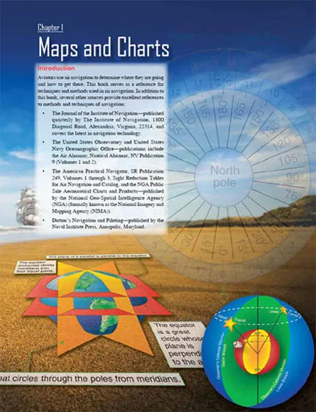
![]()
Basic Terms
Basic to the study of navigation is an understanding of certain terms that could be called the dimensions of navigation. The navigator uses these dimensions of position, direction, distance, altitude, and time as basic references. A clear understanding of these dimensions as they relate to navigation is necessary to provide the navigator with a means of expressing and accomplishing the practical aspects of air navigation. These terms are defined as follows:
• Position—a point defined by stated or implied coordinates. Though frequently qualified by such adjectives as estimated, dead reckoning (DR), no wind, and so forth, the word position always refers to some place that can be identified. It is obvious that a navigator must know the aircraft’s current position before being able to direct the aircraft to another position or in another direction.
• Direction—the position of one point in space relative to another without reference to the distance between them. Direction is not in itself an angle, but it is often measured in terms of its angular distance from a referenced direction.
• Distance—the spatial separation between two points, measured by the length of a line joining them. On a plane surface, this is a simple problem. However, consider distance on a sphere, where the separation between points may be expressed as a variety of curves. It is essential that the navigator decide exactly how the distance is to be measured. The length of the line can be expressed in various units (e.g., nautical miles (NM) or yards).
• Altitude—the height of an aircraft above a reference plane. Altitude can be measured as absolute or pressure. Absolute altitude is measured by a radar altimeter, and pressure altitude is measured from various datum planes. Compare with elevation, which is the height of a point or feature on the earth above a reference plane.
• Time—defined in many ways, but definitions used in navigation consist mainly of:
1. Hour of the day.
2. Elapsed interval.
• Methods of expression—the methods of expressing position, direction, distance, altitude, and time are covered fully in appropriate chapters. These terms, and others similar to them, represent definite quantities or conditions that may be measured in several different ways. For example, the position of an aircraft may be expressed in coordinates, such as a certain latitude and longitude. The position may also be expressed as 10 miles south of a certain city. The study of navigation demands the navigator learn how to measure quantities, such as those just defined and how to apply the units by which they are expressed.
The Earth
Shape and Size
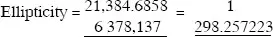
For most navigational purposes, the earth is assumed to be a perfect sphere, although in reality it is not. Inspection of the earth’s crust reveals there is a height variation of approximately 12 miles from the top of the tallest mountain to the bottom of the deepest point in the ocean. A more significant deviation from round is caused by a combination of the earth’s rotation and its structural flexibility. When taking the ellipsoidal shape of the planet into account, mountains seem rather insignificant. The peaks of the Andes are much farther from the center of the earth than Mount Everest.
Measured at the equator, the earth is approximately 6,378,137 meters in diameter, while the polar diameter is approximately 6,356,752.3142 meters. The difference in these diameters is 21,384.6858 meters, and this difference may be used to express the ellipticity of the earth. The ratio between this difference and the equatorial diameter is:
Since the equatorial diameter exceeds the polar diameter by only 1 part in 298, the earth is nearly spherical. A symmetrical body having the same dimensions as the earth, but with a smooth surface, is called an ellipsoid. The ellipsoid is sometimes described as a spheroid, or an oblate spheroid.
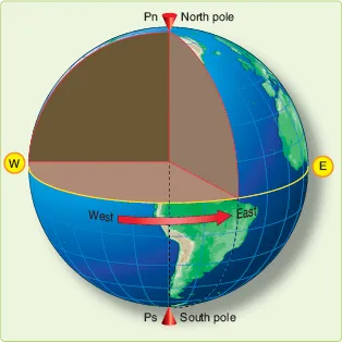
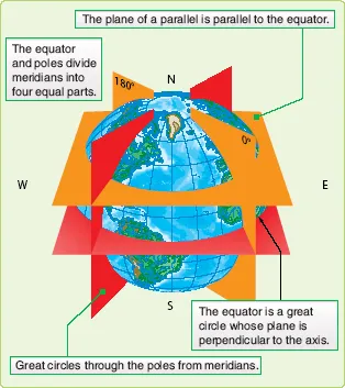
In Figure 1-1, polar north (Pn), east (E), polar south (Ps), and west (W) represent the surface of the earth. Pn and Ps represent the axis of rotation. The earth rotates from west to east. All points in the hemisphere Pn, W, Ps approach the reader, while those in the opposite hemisphere recede from the reader. The circumference W-E is called the equator, which is defined as that imaginary circle on the surface of the earth whose plane passes through the center of the earth and is perpendicular to the axis of rotation.
Great Circles and Small Circles
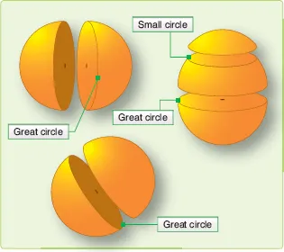
A great circle is defined as a circle on the surface of a sphere whose center and radius are those of the sphere itself. It is the largest circle that can be drawn on the sphere; it is the intersection with the surface of the earth of any plane passing through the earth’s center. The arc of a great circle is the shortest distance between two points on a sphere, just as a straight line is the shortest distance between two points on a plane. On any sphere, an indefinitely large number of great circles may be drawn through any point, though only one great circle may be drawn through any two points not diametrically opposite. Several great circles are shown in Figure 1-2.
Figure 1-1. Schematic representation of the earth showing its axis of rotation and equator.
Figure 1-2. A great circle is the largest circle in a sphere.
Circles on the surface of the sphere, other than great circles, may be defined as small circles. A small circle is a circle on the surface of the earth whose center and/or radius are not that of the sphere. A set of small circles, called latitude, is discussed later. In summary, the intersection of a sphere and a plane is a great circle if the plane passes through the center of the sphere and a small circle if it does not.
Latitude and Longitude
The nature of a sphere is such that any point on it is exactly like any other point. There is neither beginning nor ending as far as differentiation of points is concerned. In order that points may be located on the earth, some points or lines of reference are necessary so that other points may be located with regard to them. The location of New York City with reference to Washington, D.C. can be stated as a number of miles in a certain direction from Washington. Any point on the earth can be located in this manner.
Imaginary Reference Lines
Such a system, however, does not lend itself readily to navigation, because it would be difficult to locate a point precisely in mid-ocean without any nearby geographic features to use for reference. We use a system of coordinates to locate positions on the earth by means of imaginary reference lines. These lines are known as parallels of latitude and meridians of longitude.
Latitude
Once a day, the earth rotates on its north-south axis, which is terminated by the two poles. The equatorial plane is constructed at the midpoint of this axis at right angles to it. [Figure 1-3] A great circle drawn through the poles is called a meridian, and an infinite number of great circles may be constructed in this manner. Each meridian is divided into four quadrants by the equator and the poles. The circle is arbitrarily divided into 360°, and each of these quadrants contains 90°.
Figure 1-3. Planes of the earth.
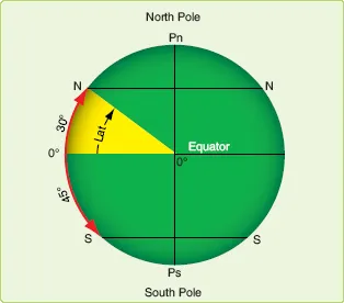
Take a point on one of these meridians 30° N of the equator. Through this point passes a plane perpendicular to the north-south axis of rotation. This plane is parallel to the plane of the equator as shown in Figure 1-3 and intersects the earth in a small circle called a parallel or parallel of latitude. The particular parallel of latitude chosen as 30° N, and every point on this parallel is at 30° N. In the same way, other parallels can be constructed at any desired latitude, such as 10°, 40°, etc.
Bear in mind that the equator is drawn as the great circle; midway between the poles and parallels of latitude are small circles constructed with reference to the equator. The angular distance measured on a meridian north or south of the equator is known as latitude [Figure 1-4] and forms one component of the coordinate system.
Figure 1-4. Latitude as an angular measurement.
Longitude
The latitude of a point can be shown as 20° N or 20° S of the equator, but there is no way of knowing whether one point is east or west of another. This difficulty is resolved by use of the other component of the coordinate system, longitude, which is the measurement of this east-west distance. Longitude, unlike latitude, has no natural starting point for numbering. The solution has been to select an arbitrary starting point. A great many places have been used, but when the English-speaking people began to make charts, they chose the meridian through their principal observatory in Greenwich, England, as the origin for counting longitude. This Greenwich meridian is sometimes called the prime meridian, though actually it is the zero meridian. Longitude is counted east and west from this meridian through 180°. [Figure 1-5] Thus, the Greenwich meridian is the 0° longitude on one side of the earth and, after crossing the poles, it becomes the 180th meridian (18...