The first local history of Napoleonic France to appear in the English language, Inside Napoleonic France: State and Society in Rouen, 1800-1815 redresses the traditional neglect of regional history during this period. Relying on extensive French archival sources, Gavin Daly sets out to investigate the nature of the Napoleonic state and its short and longer-term impact upon local society. Specifically, it examines the question of state power and its implementation and reception at a local level, the relationship between central government and the regions, the social and economic impact of war and how the Napoleonic regime addressed Rouen's revolutionary past. Having carefully studied these issues, Daly argues that despite an unprecedented degree of social control, the Napoleonic state was not all-powerful, and that the central government's power was tempered by local considerations. It is this interaction between the representatives of central government and the regional elites which provides the central focus of the book.
Preguntas frecuentes
¿Cómo cancelo mi suscripción?
Simplemente, dirígete a la sección ajustes de la cuenta y haz clic en «Cancelar suscripción». Así de sencillo. Después de cancelar tu suscripción, esta permanecerá activa el tiempo restante que hayas pagado. Obtén más información aquí.
¿Cómo descargo los libros?
Por el momento, todos nuestros libros ePub adaptables a dispositivos móviles se pueden descargar a través de la aplicación. La mayor parte de nuestros PDF también se puede descargar y ya estamos trabajando para que el resto también sea descargable. Obtén más información aquí.
¿En qué se diferencian los planes de precios?
Ambos planes te permiten acceder por completo a la biblioteca y a todas las funciones de Perlego. Las únicas diferencias son el precio y el período de suscripción: con el plan anual ahorrarás en torno a un 30 % en comparación con 12 meses de un plan mensual.
¿Qué es Perlego?
Somos un servicio de suscripción de libros de texto en línea que te permite acceder a toda una biblioteca en línea por menos de lo que cuesta un libro al mes. Con más de un millón de libros sobre más de 1000 categorías, ¡tenemos todo lo que necesitas! Obtén más información aquí.
¿Perlego ofrece la función de texto a voz?
Busca el símbolo de lectura en voz alta en tu próximo libro para ver si puedes escucharlo. La herramienta de lectura en voz alta lee el texto en voz alta por ti, resaltando el texto a medida que se lee. Puedes pausarla, acelerarla y ralentizarla. Obtén más información aquí.
¿Es Inside Napoleonic France un PDF/ePUB en línea?
Sí, puedes acceder a Inside Napoleonic France de Gavin Daly en formato PDF o ePUB, así como a otros libros populares de History y World History. Tenemos más de un millón de libros disponibles en nuestro catálogo para que explores.
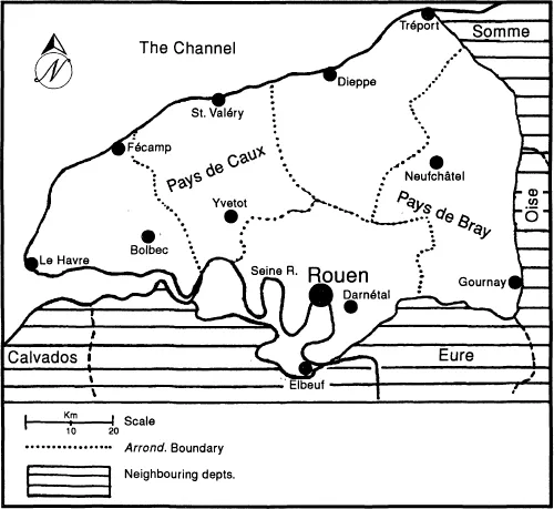
The department of the Seine-Inférieure was created in 1790 and so named because it was crossed by the downstream sections of the Seine as it flowed into the Channel. The department was bordered to the north and west by the Channel, to the north-east by the department of the Somme, to the east by the department of the Oise, and to the south by the department of the Eure. Together with the department of the Eure, it had constituted the généralité of Rouen under the ancien régime and formed the region of upper Normandy. From 1800, following the Napoleonic law of 28 Pluviôse VIII (17 February 1800), the department was subdivided into five administrative arrondissements, each named after its administrative centre: Rouen, Yvetot, Le Havre, Dieppe and Neufchâtel.
The Seine-Inférieure was geographically diverse. Its total surface area of 621,457 hectares comprised four principal regions: the plains of the west (Pays de Caux), the prairies and valleys of the east (Pays de Bray), the Seine valley (running westward from Elbeuf to the Channel) and the coastal hinterland.1 Unlike lower Normandy, the countryside of the Seine-Inférieure was free of bocage, and not extensively forested. Forests made up only one-fourteenth of the total surface area.2 The chief forests were along the Seine valley and the Forêt d’Eu (in the northern extremity of the department alongside the river Bresle) and the Forêt d’Eawy (west of Neufchâtel); the west and the coastline had long since been cleared of woodland. The Seine-Inférieure was both an agricultural and manufacturing department. Cereal crops, butter and cheese, mutton and cattle were the chief agricultural pursuits. Local industry was primarily concerned with textile manufacturing. The prefect, Jean-Claude Beugnot, had observed: ‘Most other departments of the Republic, by virtue of their soil, their location, their commercial links and even the character of their inhabitants are either manufacturing or agricultural. The department of the Seine-Inférieure is both agricultural and manufacturing at the same time.’3
Map 1.1The Department of the Seine-Inférieure
Industry and farming co-existed, especially in the Pays de Caux. The Caux was the most extensive geographical region of the Seine-Inférieure; being a plateau that covered the western half of the department, ending roughly between Dieppe and Rouen. It was the richest grain producing area of the department, indeed Guy Lemarchand has found that its harvest yields during the eighteenth century were comparable to the best grain producing regions of Western Europe.4 It provided most of the department’s wheat, barley, rye and oats. Prior to the Revolution, the farms of the Caux were favoured by the nobles – including Rouen parlementaires – and wealthy bourgeoisie from neighbouring towns and cities, especially Rouen.5 Land-holdings in the Caux were typically the largest in the department. At the end of the eighteenth century, 8 per cent of the farmers of the Caux owned farms of 40 hectares or more and collectively owned 53 per cent of the region’s total farming land.6
Many inhabitants of the Pays de Caux supplemented their agricultural incomes with cottage spinning and weaving.7 The putting-out system predominated: town and city merchants, chiefly from Rouen, supplied rural households with raw cotton and yarn which were spun and woven by hand on spinning wheels and looms. At first, rural workers and small tenant landholders used spinning and weaving to supplement their agricultural work. But as the eighteenth century progressed and the demand for cotton grew, merchants increasingly competed with farmers for rural labour. The Englishman, Arthur Young, travelling through the department in the final days of the ancien régime, claimed this trend had adversely affected the agricultural performance of the region.8
In the east, the Pays de Bray was the department’s second major agricultural region. It comprised rich prairie lands, and its dairy cows produced the region’s renowned butter and cheese, much of which was exported to Paris. The farms were smaller than those in the Caux and generally run by tenant farmers rather than rich landowners. Approximately 38 per cent of the farmers owned ten hectares or less, whilst only 4 per cent possessed properties greater than 40 hectares.9 Both the coastal region and the Seine valley, however, were considerably less fertile than the Pays de Caux and Bray. The poor quality soils of the Seine valley gave little incentive for forest clearance and encouraged instead the development of textile industries. The soil of the coastal hinterland was only marginally better, although it did allow for the cultivation of hemp and flax, especially around Fécamp.10
One of the defining characteristics of the Seine-Inférieure was its large population and high degree of urbanisation. It was among the most populous departments in France: a census of 1801 estimated the department’s population at 609,743 inhabitants,11 whilst prefectoral subsistence statistics for the following year give a slightly higher figure of 623,000.12 In 1794–1795, the department had 1003 communes,13 with 17 having populations greater than 2000 inhabitants.14 Based on a national inquiry of the Constituent Assembly in 1791, the Seine-Inférieure was the fourth most highly urbanised department in France, with 41 per cent of its population living in cities and towns.15 As Table 1.1 highlights, this population was concentrated in the Rouen region, whilst the western arrondissements were more populous than that of Neufchâtel in the east.
Table 1.1 Population of the Seine-Inférieure, 1801
Arrondissement
Population
Rouen
194,349
Yvetot
123,268
Le Havre
112,826
Dieppe
100,675
Neufchâtel
78,625
Total
609,743
Source: 1801 census figures cited in W. Pruitt, Opposition to the Bourbon Restoration in Rouen and the Seine-Inférieure, 1814-1830, unpublished Ph.D. dissertation, University of Virginia, 1981, p. 29.
After Rouen, the largest cities of the department were the important Channel ports of Le Havre and Dieppe. They each had approximately 20,000 inhabitants at the end of the eighteenth century.16 Le Havre was situated at the mouth of the Seine and was a major commercial and naval port. After Nantes, Le Havre was the most important French port for triangular trade in the late eighteenth century.17 Its industries included shipbuilding and tobacco processing. Dieppe, 90 km north of Le Havre, was the department’s premier fishing port. It was also a commercial port, a naval base (2800 sailors were stationed there in 1792)18 and a centre for shipbuilding and other ancillary maritime industries such as net, rope and sail-making. Other lesser Channel ports included Fécamp (population of 7623 in 1800), St Valéry (4858) and Tréport (1500).19
In the interior of the department, the chief urban centres were manufacturing and market towns. In the west, Yvetot (1790 population 8100)20 was a textile manufacturing and market town in the centre of the Pays de Caux. Between Yvetot and Le Havre was the wool and handkerchief manufacturing town of Bolbec (1790 population 4300). In the Seine valley to the south-east of the department were the dynamic wool centres of Elbeuf (population of 7500 during the Empire)21 and Darnétal (1790 population 7000). In the Pays de Bray were the market towns of Neufchâtel (1790 population 3600) and Gournay (1790 population 3600), the latter being a centre for butter production and distribution. Yet the city that dwarfed all others in terms of population, and economic, religious, administrative and political importance, was Rouen.
The City of Rouen: Urban and Human Geography
The city of Rouen was situated in a valley beneath hills on the right bank of a dramatic meander of the Seine as it swept through the southern extremity of the department of the Seine-Inférieure. The city’s favourable location on the Seine with access to the Channel had been instrumental in making it the economic capital of Normandy and one of the great commercial entrepôts of western Europe, distinguished by its extensive maritime commerce and the quality of its textile industry. The Seine was the only navigable river in the department and Rouen was in the privileged position of being 150 km upstream of...